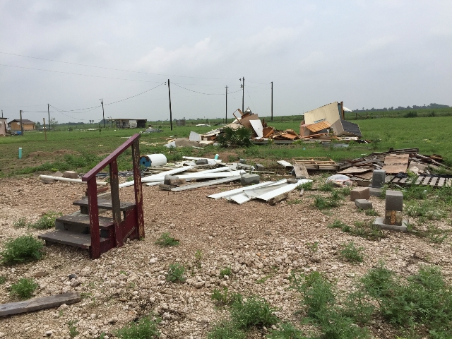
 Photos taken from a National Weather Service and Emergency Management Survey after widespread wind damage struck the Donna/Weslaco area. Credit: National Weather Service Brownsville/Rio Grande Valley, NWS Brownsville/Rio Grande Valley social media followers, and others. |
|
| Stormy Weather: Microburst Slams Mid–Valley; Scores of Poorly Built Homes Impacted April 24th Mayhem Rips Up Colonias, Removes Thousands of Ash Tree Limbs |
|
|
After a little more than two weeks of near–misses and being on edge for damaging thunderstorms (but plenty of rain and lightning), the atmosphere saved its "worst" for last. A small cluster of thunderstorms developed within a favorable zone for rapid updrafts over eastern Nuevo León State, Mexico, during the mid evening of April 24th. Unlike previous severe storms in April 2015, which produced similar wind damage and some hail across the Rio Grande Plains of Zapata and Jim Hogg County on April 12th and again on the 17th but weakened to mainly rain and lightning for the Valley, this small cluster moved at a steady clip – up to 40 mph at times –, into the easily lifted warmest and most humid low level air mass seen during the period. The result was an atmospheric bulldozer, crashing from the sky to the ground and racing to the northeast and east–northeast at speeds ranging from 65 to 80 mph. The initial cell likely produced large hail in Nuevo León before evolving into a straight–line wind event while crossing into Tamaulipas as it bent to the northeast just after 1030 PM local time. There was likely wind damage across the border from Pharr and Donna before the winds crashed across the river at the Lower Rio Grande Valley National Wildlife Refuge (Santa Ana). In only fifteen minutes, structural, tree, and powerline/power pole damage piled up from Alamo to Mercedes, extending north to pockets in Edinburg, Elsa, and Edcouch. The heaviest damage was noted in Donna and Weslaco, where a National Weather Service survey, joined by Emergency Management from Weslaco/Donna/Mercedes, Elsa/Edcouch, and Hidalgo County, determined peak winds ranged from 65 to 75 mph, with pockets of 80 mph speeds based on the type of damage, exposure, and construction. A second core of strong winds ripped through southwest Cameron County, with unknown tree damage in the Santa Maria/Los Indios area that continued northeast into the Harligen/Primera area before exiting near Rio Hondo. Rainfall was quick, but hard; locations on the core of the heaviest rain received between ½ and 1 inch. |
|
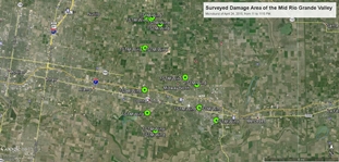 Click on this map to open a .kmz file to display survey data from more than 20 points/photos in the Weslaco/Donna area damaged by microburst on April 24, 2015. Need Google Earth? Download here. |
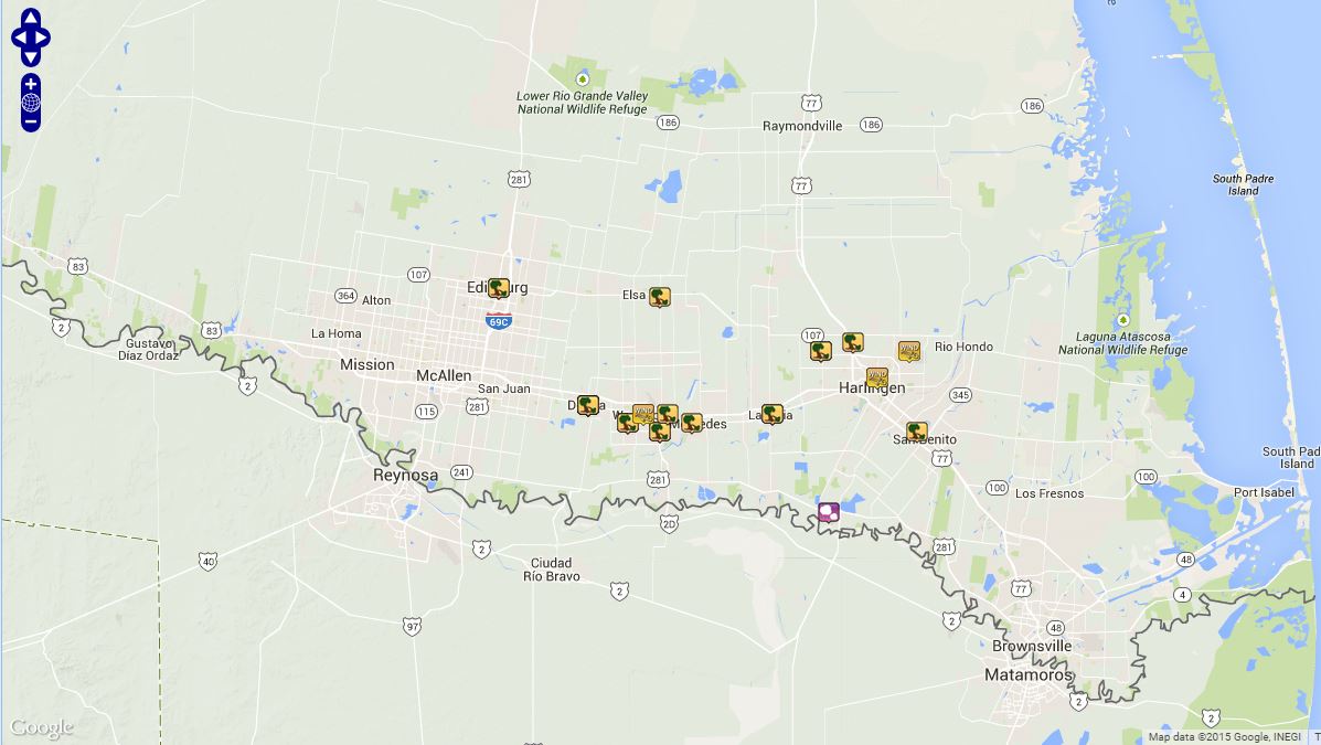 Preliminary local storm report map from Lower/Mid Valley microburst(s) of April 24, 2015. For full accessibility, including radar images, click here. |
|
The following is a preliminary list of talking points from the April 24th microbursts. Preliminary local storm report(s) follow the velocity image loop below this section.
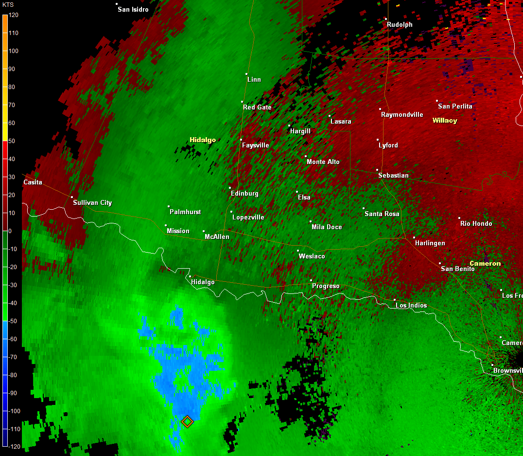 0.5° Base Velocity loop from 1045 through 1142 PM CDT, April 24th 2015. Note core of very strong winds (light to medium blue) that cross the mid Valley. The colors indicated generally 60 to 75 mph (radar indicated) at 4500 to 5000 feet above ground; much of the wind reached the ground, causing the damage. 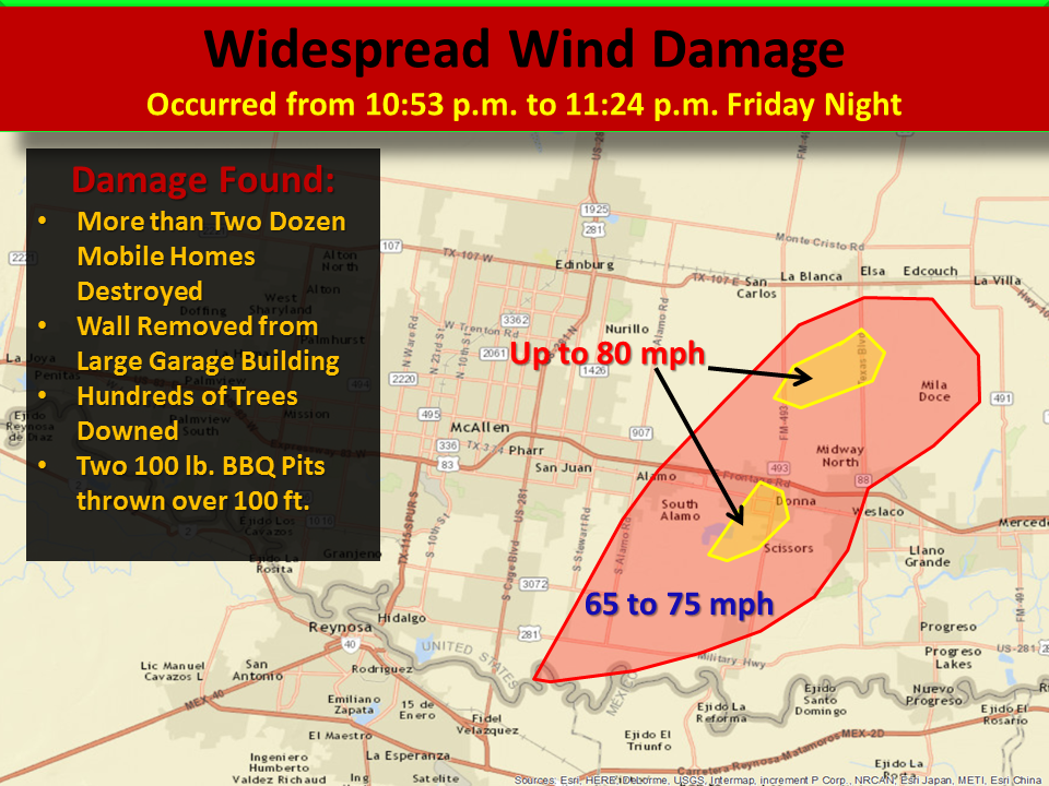 Preliminary wind speed and quick impact graphic from April 24, 2015 microburst in southern Hidalgo County, Texas Below is the preliminary text storm report summary from April 24th, 2015. Note: Some times were adjusted based on survey results and radar estimates.
PRELIMINARY LOCAL STORM REPORT...SUMMARY
NATIONAL WEATHER SERVICE BROWNSVILLE TX
415 AM CDT SAT APR 25 2015

..TIME...   ...EVENT...      ...CITY LOCATION...     ...LAT.LON...
..DATE...   ....MAG....      ..COUNTY LOCATION..ST.. ...SOURCE....
            ..REMARKS..

1100 PM     TSTM WND DMG     DONNA                   26.17N  98.05W
04/24/2015                   HIDALGO            TX   LAW ENFORCEMENT

            HIDALGO COUNTY SO REPORTS MOBILE HOME FLIPPED OVER ON
            NOEMI STREET IN DONNA.

1100 PM     TSTM WND DMG     DONNA                   26.17N  98.05W
04/24/2015                   HIDALGO            TX   LAW ENFORCEMENT

            HIDALGO COUNTY SO REPORTS UNOCCUPIED CAR FLIPPED OVER
            BY STRONG WINDS AT THE SIOUX ROAD AND HUTTO ROAD
            INTERSECTION IN DONNA.

1100 PM     TSTM WND DMG     EDINBURG                26.30N  98.16W
04/24/2015                   HIDALGO            TX   LAW ENFORCEMENT

            HIDALGO COUNTY SO REPORTS MOBILE HOME DAMAGE AT THE
            TOWER ROAD AND OWASSA ROAD INTERSECTION IN EDINBURG.

1100 PM     TSTM WND DMG     DONNA                   26.17N  98.05W
04/24/2015                   HIDALGO            TX   LAW ENFORCEMENT

            DONNA POLICE DEPARTMENT REPORTS MOBILE HOME FLIPPED
            OVER ON PONCIANO DRIVE JUST NORTH OF DONNA.

1100 PM     TSTM WND DMG     DONNA                   26.17N  98.05W
04/24/2015                   HIDALGO            TX   LAW ENFORCEMENT

            HIDALGO COUNTY SO REPORTS WIRE FENCE BLOWN DOWN ON
            MIRASOL ROAD IN DONNA.

1100 PM     TSTM WND DMG     DONNA                   26.17N  98.05W
04/24/2015                   HIDALGO            TX   LAW ENFORCEMENT

            DONNA POLICE DEPARTMENT REPORTS TREE AND UTILITY POLE
            DAMAGE ON NUMEROUS STREETS... INCLUDING SOUTH VICTORIA
            ROAD... MAIN STREET... HUTTO ROAD... AND VAL VERDE.

1100 PM     TSTM WND DMG     EDINBURG                26.30N  98.16W
04/24/2015                   HIDALGO            TX   LAW ENFORCEMENT

            HIDALGO COUNTY SO REPORTS ALUMINUM FENCE BLOWN OVER ON
            OWASSA ROAD IN EDINBURG.

1118 PM     TSTM WND GST     WESLACO                 26.16N  97.98W
04/24/2015  M72 MPH          HIDALGO            TX   TRAINED SPOTTER

            TRAINED SPOTTER REPORTED 63 KT WIND GUSTS AT
            INTERSECTION OF 88TX AND MILE 1 1/2 ROAD.**TIME ESTIMATED**

1120 PM     TSTM WND DMG     2 SE WESLACO            26.14N  97.96W
04/24/2015                   HIDALGO            TX   EMERGENCY MNGR

            EMERGENCY MANAGER OF WESLACO REPORTED SEVERAL TREES
            DOWN IN THE PLEASANTVIEW AREA NEAR WESLACO. TIME
            ESTIMATED FROM RADAR.

1120 PM     TSTM WND DMG     LA FERIA                26.16N  97.82W
04/24/2015                   CAMERON            TX   LAW ENFORCEMENT

            LA FERIA POLICE DEPARTMENT REPORTS TREE BLOWN DOWN ONTO
            PARKER ROAD IN LA FERIA.

1120 PM     TSTM WND DMG     1 SW WESLACO            26.15N  98.00W
04/24/2015                   HIDALGO            TX   PUBLIC

            PUBLIC REPORTED BACKYARD METAL PERGOLA DESTROYED ON THE
            SOUTHWEST SIDE OF WESLACO. TIME ESTIMATED FROM RADAR.

1125 PM     TSTM WND DMG     2 E WESLACO             26.16N  97.95W
04/24/2015                   HIDALGO            TX   BROADCAST MEDIA

            REPORT OF ROAD SIGNS BLOWN OUT OF THE GROUND ALONG US
            83 NEAR WESLACO.

1125 PM     TSTM WND DMG     EDCOUCH                 26.29N  97.96W
04/24/2015                   HIDALGO            TX   LAW ENFORCEMENT

            SEVERAL POWERLINES DOWN IN THE CITY OF EDCOUCH. TIME
            ESTIMATED FROM RADAR.

1130 PM     TSTM WND DMG     LA FERIA                26.16N  97.82W
04/24/2015                   CAMERON            TX   LAW ENFORCEMENT

            CAMERON COUNTY SO REPORTS 2 TREES DOWN ON FM 506 SOUTH
            OF CLARK ROAD IN LA FERIA.

1130 PM     TSTM WND DMG     PRIMERA                 26.23N  97.76W
04/24/2015                   CAMERON            TX   LAW ENFORCEMENT

            CAMERON COUNTY SO REPORTS UTILITY WIRES BLOWN DOWN INTO
            THE ROAD IN PRIMERA.

1130 PM     TSTM WND DMG     COMBES                  26.24N  97.72W
04/24/2015                   CAMERON            TX   LAW ENFORCEMENT

            CAMERON COUNTY SO REPORTS TREE BLOWN DOWN ONTO HAND
            ROAD IN COMBES.

1130 PM     TSTM WND DMG     HARLINGEN               26.20N  97.69W
04/24/2015                   CAMERON            TX   LAW ENFORCEMENT

            HARLINGEN POLICE DEPARTMENT REPORTS TWO MEDIUM-SIZED
            TREES BLOWN DOWN ONTO GARRETT ROAD IN HARLINGEN.

1130 PM     TSTM WND DMG     SAN BENITO              26.14N  97.64W
04/24/2015                   CAMERON            TX   LAW ENFORCEMENT

            SAN BENITO POLICE DEPARTMENT REPORTS 1 TREE BLOWN DOWN
            ONTO SOUTH SAM HOUSTON. ALSO TRAMPOLINE BLOWN INTO SIDE
            OF HOUSE THAT CAUSED WINDOWS TO BREAK ON SAN JACINTO
            DRIVE. ALSO DOWNED LIVE UTILITY WIRE AT INTERSECTION OF
            SOUTH DICK DOWLING AND ROWSEN AND ANOTHER LIVE WIRE DOWN
            ON ZILLOCK ROAD. ALL IN SAN BENITO.

1130 PM     TSTM WND DMG     MERCEDES                26.15N  97.92W
04/24/2015                   HIDALGO            TX   LAW ENFORCEMENT

            MERCEDES POLICE DEPARTMENT REPORTS 10 TO 12 POWER LINES
            AND 15 TO 20 TREES DOWN ACROSS THE CITY OF MERCEDES.

1135 PM     TSTM WND GST     HARLINGEN VALLEY AIRPOR 26.23N  97.65W
04/24/2015  M58 MPH          CAMERON            TX   ASOS

            HARLINGEN ASOS AT VALLEY INTERNATIONAL AIRPORT REPORTED
            A 58 MPH MEASURED WIND GUST.

1135 PM     TSTM WND GST     HARLINGEN               26.20N  97.69W
04/24/2015  M60 MPH          CAMERON            TX   PUBLIC

            PUBLIC REPORTED A MEASURED 60 MPH WIND GUST WITH A
            DAVIS INSTRUMENT IN HARLINGEN.

1135 PM     TSTM WND DMG     PRIMERA                 26.23N  97.76W
04/24/2015                   CAMERON            TX   PUBLIC

            PUBLIC REPORTED MEDIUM SIZE TREE DOWN ON A CAR IN
            PRIMERA VIA SOCIAL MEDIA.

1137 PM     HAIL             LOS INDIOS              26.05N  97.75W
04/24/2015  E1.00 INCH       CAMERON            TX   TRAINED SPOTTER

            TRAINED SKYWARN SPOTTER IN LOS INDIOS REPORTED
            QUARTER-SIZE HAIL.
|
|
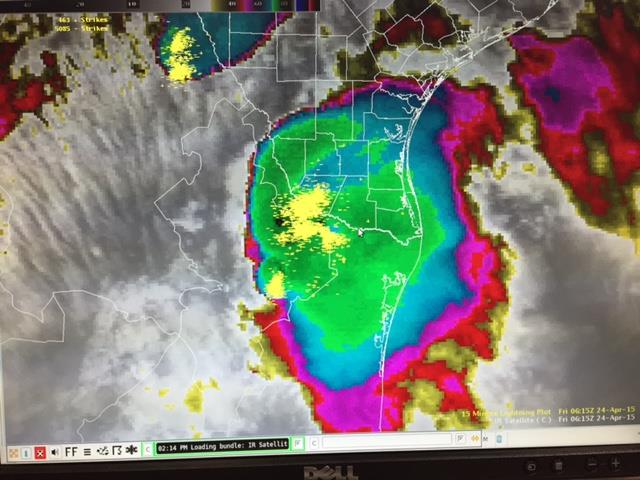 Satellite photo with lightning overlaid of Mesoscale Convective System that dropped heavy rain in Starr County. The heaviest rain fell generally from 1230 to 130 AM. Click image for a full loop of the storm across the Upper Rio Grande Valley. The Night Before: Thunderstorm Complex Soaks Starr County The Rio Grande Valley was close to being hit by back–to–back significant impact weather on successive nights. During the evening of April 23rd, thunderstorms, some likely with large hail and damaging wind, formed in Nuevo Leóon. By midnight, the storms had weakened below severe limits (58 mph wind and 1 inch diameter hail) but organized into a Mesoscale Convective System (What’s a Mesoscale Convective System?) (MCS), typically more conducive to flooding in the Rio Grande Valley. Between 1230 and 130 AM on the 24th, 2 to 3 inches (estimated) of rain fell over and near Rio Grande City, flooding dozens of roads with up to a foot of flowing water as the rains began to subside. As the system punched northesat toward the South Texas Brush Country and Coastal Bend, the flood threat waned. Accompanying the rain was frequent cloud–to–ground lightning with hundreds of strikes in Starr County in a short time; several thousand customers in Starr and western Hidalgo lost power from the strikes. Another threat developed after the rains ended. MCSs often produce a pressure couplet of small scale high pressure, where cold, dense air descended from the core of the rain and hail production area, and a "wake" low pressure area after the system passes. For the early April 24th MCS, the difference between high and low pressure increased across the Brooks and Kenedy County ranchlands, where southerly winds (with no rain) gusted to 35 to 40 mph, if not higher (Kingsville, in Kleberg County, briefly reached 50 mph). Strongest winds, including some damage, were reported across the South Texas Brush Country east to the Coastal Bend, including Corpus Christi. A report on these rare but notable impacts for South Texas north of the RGV is here. There were benefits of this particular round of rain; the last sliver of Starr County not in "Exceptional Wetness" from the Standardized Precipitation Index in 2015 was now bumped up to the wettest category of the index (below), joining all but the South Padre Island beaches. 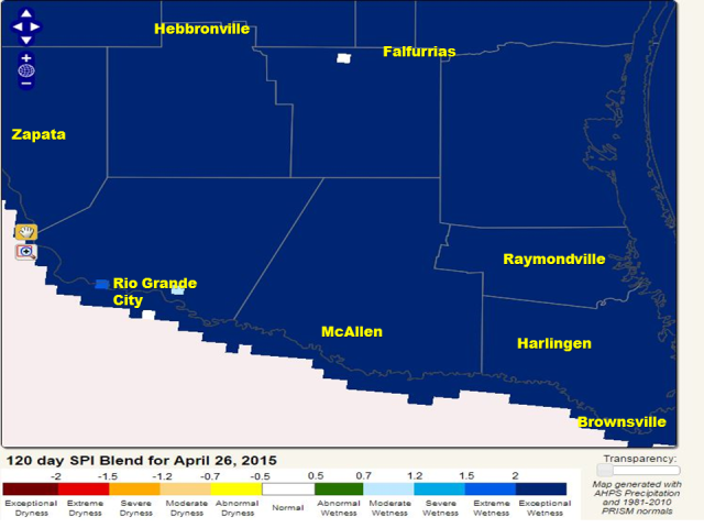 |

