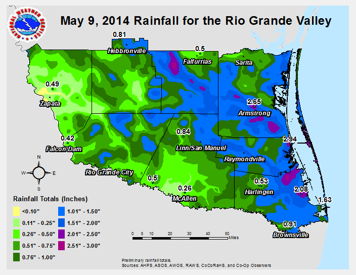
 Rainfall Across the Rio Grande Valley/Deep South Texas ranchlands during the evening of May 9, 2014. |
|||||||||||||||||||||||||||||||||||||||||||||||||||||||||||||||||||||||||
| Squall Roars Across Ranchlands, Portions of Lower Valley May 9th Wind, Rain, and Lightning Alters Evening Plans for Many |
|||||||||||||||||||||||||||||||||||||||||||||||||||||||||||||||||||||||||
|
Summary, in Brief Initial cells along the forming line produced wind gusts to near 70 mph in Laredo, along with notable damage. The continuation of strong winds produced pockets of damage in Jim Hogg, Zapata, and Starr County (below). 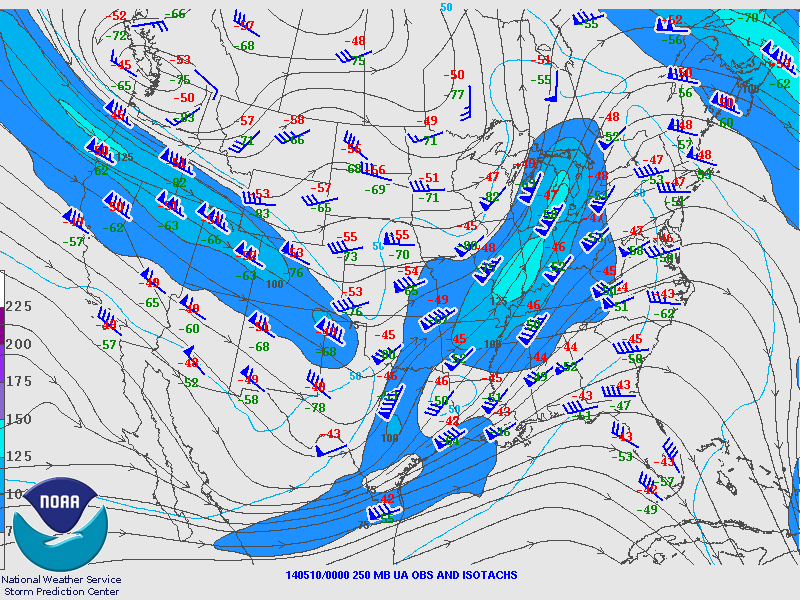 250 mb chart of streamlines (arrowed lines), isotachs (lines of equal wind), and observed wind and temperature, at around 7 PM May 9th. Note the small area of 100+ knot wind in south central Texas, with a pocket of less than 75 knot wind just north of the Rio Grande Valley. This difference was one factor in creating sufficient lift to help organize the line of strong to severe storms. |
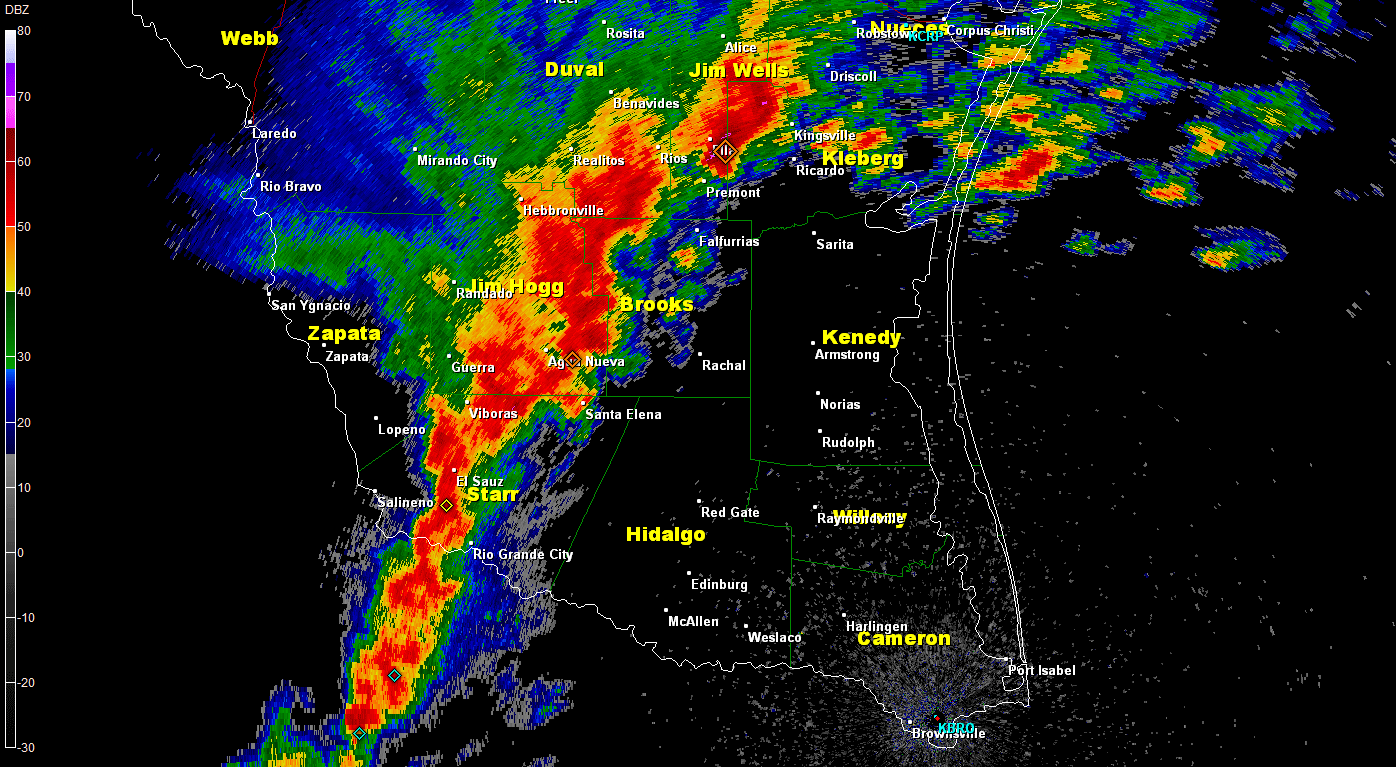
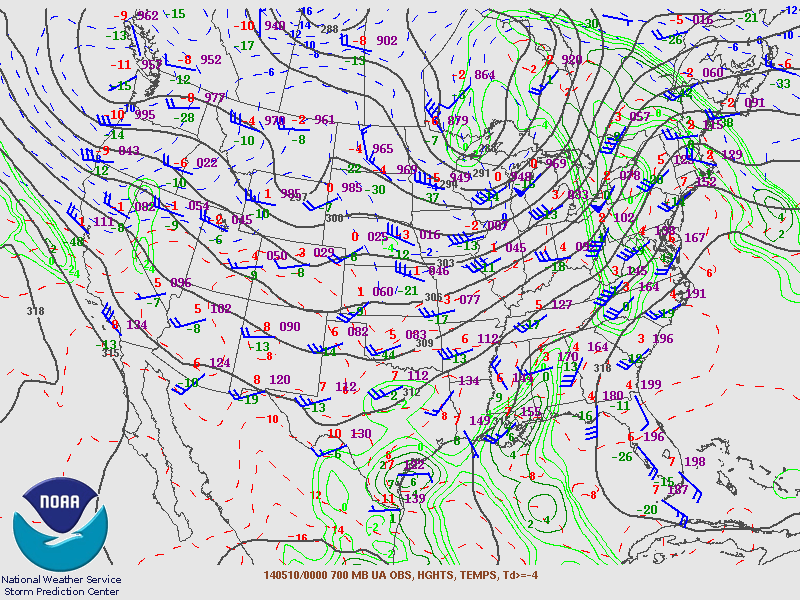 Chart showing the height (in meters) of the 700 mb surface, observed winds and temperatures, and areas where moisture had "pooled" (Dew point temperature ≥-4°C), at around 7 PM May 9th. Note the area of >4°C dewpoint across Deep South Texas. This moisture, combined with cooler and somewhat drier air sliding over top of it, was sufficient to maintain the squall line as it approached and moved off the coast. Two clusters of developing storms, one edging south from the South Texas Brush Country and a second sliding east from the Rio Grande Plains, merged into a northeast–to–southwest oriented line at around 7 PM, extending from western Starr County through western Brooks County. The line would plow eastward (below left), with a number of individual stronger cells embedded within the line. As the line neared Hidalgo County, the strongest cells were found north of the Rio Grande Valley, including one with several quick forming and dissipating circulations (below right). At one point, most locations in Deep South Texas and the Rio Grande Valley were under a warning for the potential for 60 to 70 mph damaging winds, and a smaller area of ranches and farms from southeastern Jim Hogg through northwestern Willacy were under tornado warnings. The action continued to press southeast during the mid evening. After a slight weakening, the squall reintensified as it moved east of U.S. 77 from southern Kenedy to the Rio Grande. The strongest measured wind gusts occurred between 10 and 1130 PM in these areas, with many locations recording gusts over 50 mph. Accompanying the gusts were sheets of rain which dropped more than 2 inches in some locations, including Bayview/Cameron County Airport (2.07"), Armstrong (Southern Kenedy County, 2.65"), and Port Mansfield (2.94", along the coast on the Willacy/Kenedy County line). The storms knocked out power to some communities, including parts of South Padre Island, and caused significant disruption to evening flights in and out of Harlingen and Brownsville. A preliminary damage report follows. |
||||||||||||||||||||||||||||||||||||||||||||||||||||||||||||||||||||||||
000
NWUS54 KBRO 101453
LSRBRO

PRELIMINARY LOCAL STORM REPORT...SUMMARY
NATIONAL WEATHER SERVICE BROWNSVILLE TX
952 AM CDT SAT MAY 10 2014

..TIME...   ...EVENT...      ...CITY LOCATION...     ...LAT.LON...
..DATE...   ....MAG....      ..COUNTY LOCATION..ST.. ...SOURCE....
            ..REMARKS..

0635 PM     TSTM WND DMG     1 N ZAPATA              26.91N  99.26W
05/09/2014                   ZAPATA             TX   LAW ENFORCEMENT

            ROOF OF A BAKERY PARTIALLY REMOVED AND BLOWN ONTO
            HIGHWAY 83.

0701 PM     TSTM WND DMG     HEBBRONVILLE            27.32N  98.69W
05/09/2014                   JIM HOGG           TX   EMERGENCY MNGR

            POWERLINES DOWN OVER THE ROADWAY IN HEBBRONVILLE.

0708 PM     TSTM WND DMG     SOUTH FORK ESTATES      27.27N  98.72W
05/09/2014                   JIM HOGG           TX   LAW ENFORCEMENT

            WIND DAMAGE TO TRAILERS AND TREES IN THE SOUTH FORK
            ESTATES AT THE INTERSECTION OF FARM TO MARKET 3073 AND
            HIGHWAY 16.

0742 PM     TSTM WND DMG     3 N RIO GRANDE CITY     26.42N  98.83W
05/09/2014                   STARR              TX   PUBLIC

            MULTIPLE LARGE TREE LIMBS DOWN ON FM 735.

0759 PM     TSTM WND DMG     HEBBRONVILLE            27.32N  98.69W
05/09/2014                   JIM HOGG           TX   LAW ENFORCEMENT

            SEVERAL POWER LINES DOWNED IN FALFURRIAS AND IN THE
            COUNTY ON HIGHWAY 223. TREES DOWN AT HIGHWAY 219 AND 206

0800 PM     TSTM WND DMG     MISSION                 26.21N  98.32W
05/09/2014                   HIDALGO            TX   PUBLIC

            LARGE LIMB OFF MESQUITE TREE...APPROXIMATELY 130
            POUNDS.

0810 PM     TSTM WND DMG     EDINBURG                26.30N  98.16W
05/09/2014                   HIDALGO            TX   FIRE DEPT/RESCUE

            SEVERAL POWER POLES DOWN AND POWER LINE TANGLED IN
            TREES THROUGHOUT THE CITY OF EDINBURG.

0826 PM     TSTM WND DMG     PALMVIEW                26.23N  98.37W
05/09/2014                   HIDALGO            TX   LAW ENFORCEMENT

            SIGNS BLOWN DOWN ON THE EXPRESSWAY...HIGHWAY
            83...INTERSTATE 2 IN PALMVIEW.

0834 PM     TSTM WND DMG     MISSION                 26.21N  98.32W
05/09/2014                   HIDALGO            TX   LAW ENFORCEMENT

            SEVERAL REPORTS OF TREES AND POWERLINES DOWNED IN
            MISSION AND SULLIVAN.

0859 PM     TSTM WND DMG     LYFORD                  26.41N  97.79W
05/09/2014                   WILLACY            TX   LAW ENFORCEMENT

            TREES DOWN IN LYFORD. SEMI TRUCK BLOWN OVER AT HIGHWAY
            1015 AND 186.

0913 PM     TSTM WND GST     EDCOUCH                 26.29N  97.96W
05/09/2014  E60 MPH          HIDALGO            TX   TRAINED SPOTTER

            SPOTTER ESTIMATES 55 TO 60 MPH WINDS IN EDCOUCH.

1130 PM     MARINE TSTM WIND 12 E SOUTH PADRE ISLAND 26.08N  96.99W
05/09/2014  M58 MPH          GMZ150             TX   COAST GUARD

            COAST GUARD RECEIVED A 50 KNOT WIND REPORT FROM A BOAT
            12 MILES EAST OF SOUTH PADRE ISLAND JETTY.
|
|||||||||||||||||||||||||||||||||||||||||||||||||||||||||||||||||||||||||
|
|||||||||||||||||||||||||||||||||||||||||||||||||||||||||||||||||||||||||
 0.5° reflectivity loop from 724 PM to 829 PM CDT across Deep South Texas and the Rio Grande Valley. Note the stronger cells across the ranchlands from Jim Hogg through northwest Willacy County. |
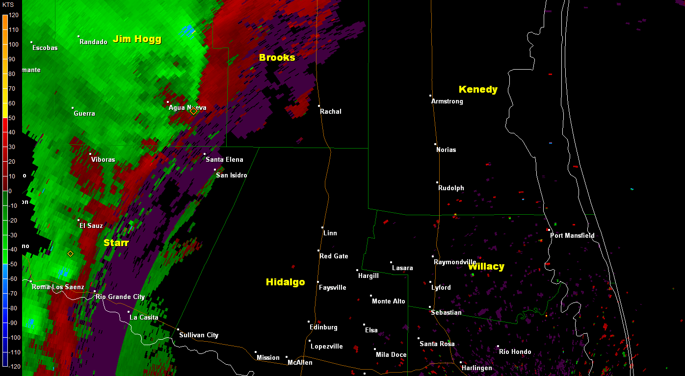 0.5° velocity loop from 724 PM to 829 PM, focused along the Deep South Texas ranchlands. Note the pockets where rotation appears (light green/blue against red) and the general "surge" of inbound (green and blue) winds racing toward the Lower RGV. |
||||||||||||||||||||||||||||||||||||||||||||||||||||||||||||||||||||||||
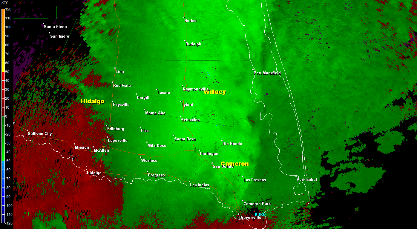 0.5° velocity loop from 946 and 1049 PM, focused along the Lower Texas coast, mainly east of Highway 77. Note the broad area of bright green and light blue, indicating radar estimated 45 to 60 mph winds - and the duration of such winds. Surface observations in the area recorded 45 to 55 mph wind gusts for up to an hour. |
|||||||||||||||||||||||||||||||||||||||||||||||||||||||||||||||||||||||||

