 Map of overall downburst area across south central Hidalgo County, with embedded damaging microbursts (bright red), that occurred between 354 and 440 PM August 13th 2014. |
 Photo of damage to porch overhang and siding at a mobile home near Edinburg. Winds were estimated between 60 and 65 mph. |
| August 13th 2014 Mid–Valley Microburst Surprise! Rare Pulse–Severe Downdraft in Late Summer Caused Sporadic Damage |
|
|
The combination of the Lower Texas coast sea breeze a weak upper level disturbance, leftover energy from an "old" surface boundary, and ample dry air mixed within an unstable atmosphere helped spark a small but potent thunderstorm in east–central Hidalgo County shortly before 4 PM August 13th, 2014. This storm would quickly produce damage just north of Mercedes and Weslaco (Hidalgo County) scoot to the west along a favorable outflow, reset, and drop another microburst between Alamo and the east side of Edinburg between 420 and 430 PM before weakening. Damage (list, below) included numerous downed tree limbs, some downed power lines (and outages), and structural damage to mobile homes. Peak measured airport gusts included 50 mph at Weslaco/Mid Valley, 45 mph at McAllen/Miller, and 33 mph at Edinburg/International(which was well north of the microburst core). Power outages were scattered but notable; a single transformer felled by snapped power poles put thousands of Edinburg residents in the dark after 430 PM. Other unknown outages likely occurred near Alamo. For a preliminary analysis of the vertical storm structure as indicated by Doppler Radar, click here. |
|
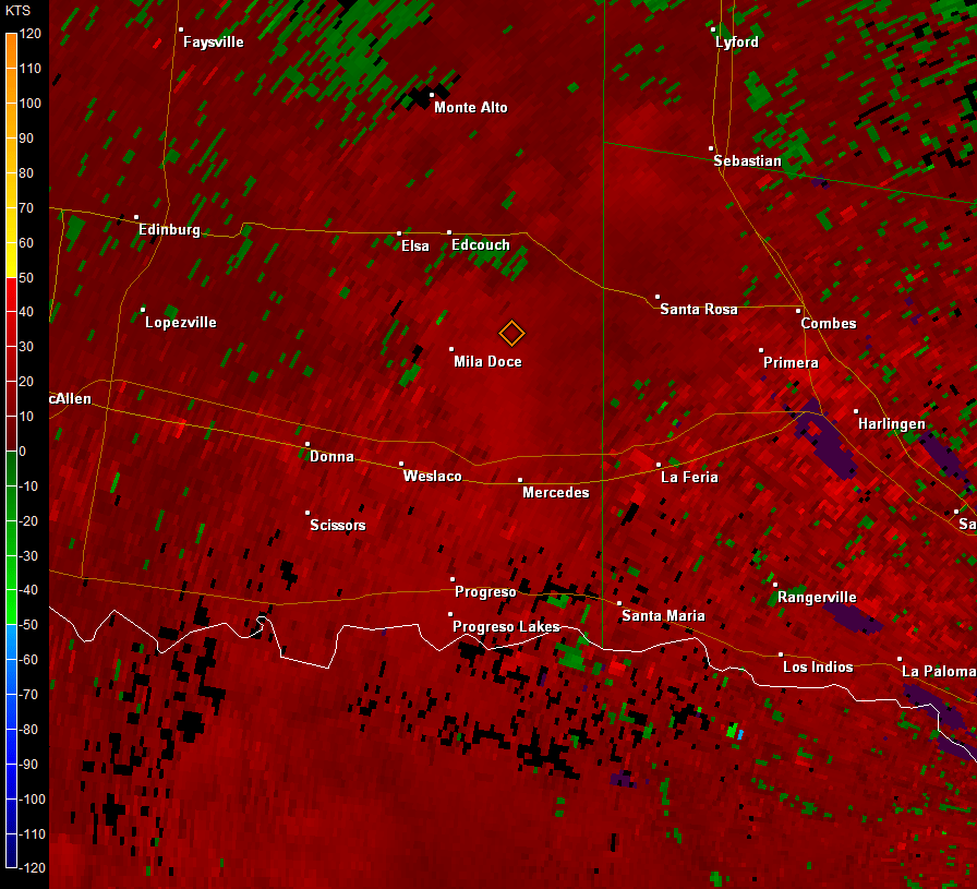 Animation of base velocity at 0.5° elevation (around 2500 to 3000 feet above ground) during period of damaging microburst and other downburst winds in Hidalgo County between 345 and 435 PM, August 13 2014. Note the brighter red cores; radar estimated 40 to 50 mph in these areas, but acceleration of wind by evaporative cooling likely brought speeds above 60 mph based on damage reports. |
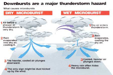 Anatomy of a Wet and Dry Microburst. For Hidalgo County on August 13, 2014, some combination of wet and dry microburst features were involved – namely, a bit more moisture to support rain at the ground, but limited amount of torrential rain which is more common in the Rio Grande Valley. |
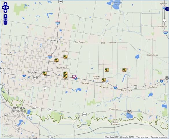 Map of damage location and single hail report across the Mid Valley on August 13, 2014. Click on the image to view an interactive map of the reports and their descriptions.
000
NWUS54 KBRO 140223
LSRBRO

PRELIMINARY LOCAL STORM REPORT...SUMMARY
NATIONAL WEATHER SERVICE BROWNSVILLE TX
922 PM CDT WED AUG 13 2014

..TIME...   ...EVENT...      ...CITY LOCATION...     ...LAT.LON...
..DATE...   ....MAG....      ..COUNTY LOCATION..ST.. ...SOURCE....
            ..REMARKS..

0354 PM     TSTM WND DMG     INDIAN HILLS            26.21N  97.92W
08/13/2014                   HIDALGO            TX   LAW ENFORCEMENT

            TWO MOBILE HOMES DEMOLISHED.

0400 PM     TSTM WND DMG     1 E MILA DOCE           26.21N  97.98W
08/13/2014                   HIDALGO            TX   EMERGENCY MGR

            TWO MOBILE HOMES WITH DAMAGE...ONE SLID OFF FOUNDATION
            AND SECOND WITH PART OF ROOF TORN OFF NEAR INTERSECTION
            OF MILE 4 WEST AND MILE 11 NORTH ROAD.  SEVERAL TREE
            LIMBS WERE KNOCKED DOWN ON POWER LINES NEARBY ALONG
            MILE 10 NORTH ROAD.

0417 PM     TSTM WND DMG     1 SE CANTU              26.20N  98.12W
08/13/2014                   HIDALGO            TX   PUBLIC

            TREES DOWN ON A FENCE.

0420 PM     TSTM WND DMG     1 ENE LOPEZVILLE        26.24N  98.15W
08/13/2014                   HIDALGO            TX   LAW ENFORCEMENT

            TREE DOWN ON A CHURCH.

0420 PM     TSTM WND DMG     1 NNW WESLACO           26.18N  97.99W
08/13/2014                   HIDALGO            TX   PUBLIC

            LARGE TREE UPROOTED.

0426 PM     TSTM WND DMG     ALAMO                   26.19N  98.12W
08/13/2014                   HIDALGO            TX   LAW ENFORCEMENT

            SEVERAL SPOTS OF TREES AND POWER LINES DOWN IN
            DONNA...ALAMO...AND SAN JUAN.

0428 PM     HAIL             2 E ALAMO               26.19N  98.09W
08/13/2014  E0.75 INCH       HIDALGO            TX   PUBLIC

0430 PM     TSTM WND DMG     EDINBURG           TX   26.30N  98.16W
                                                     LAW ENFORCEMENT

            SEVERAL POWER POLES SNAPPED; ONE WITH TRANSFORMER THAT
            FELL AND KNOCKED OUT POWER TO THOUSANDS OF RESIDENTS.
            WIND SPEED UNKNOWN.

0440 PM     TSTM WND DMG     4 SE EDINBURG           26.25N  98.12W
08/13/2014                   HIDALGO            TX   PUBLIC

            STRONG WINDS REMOVED PORCH OVERHANG FROM A MOBILE HOME
|
|

