|
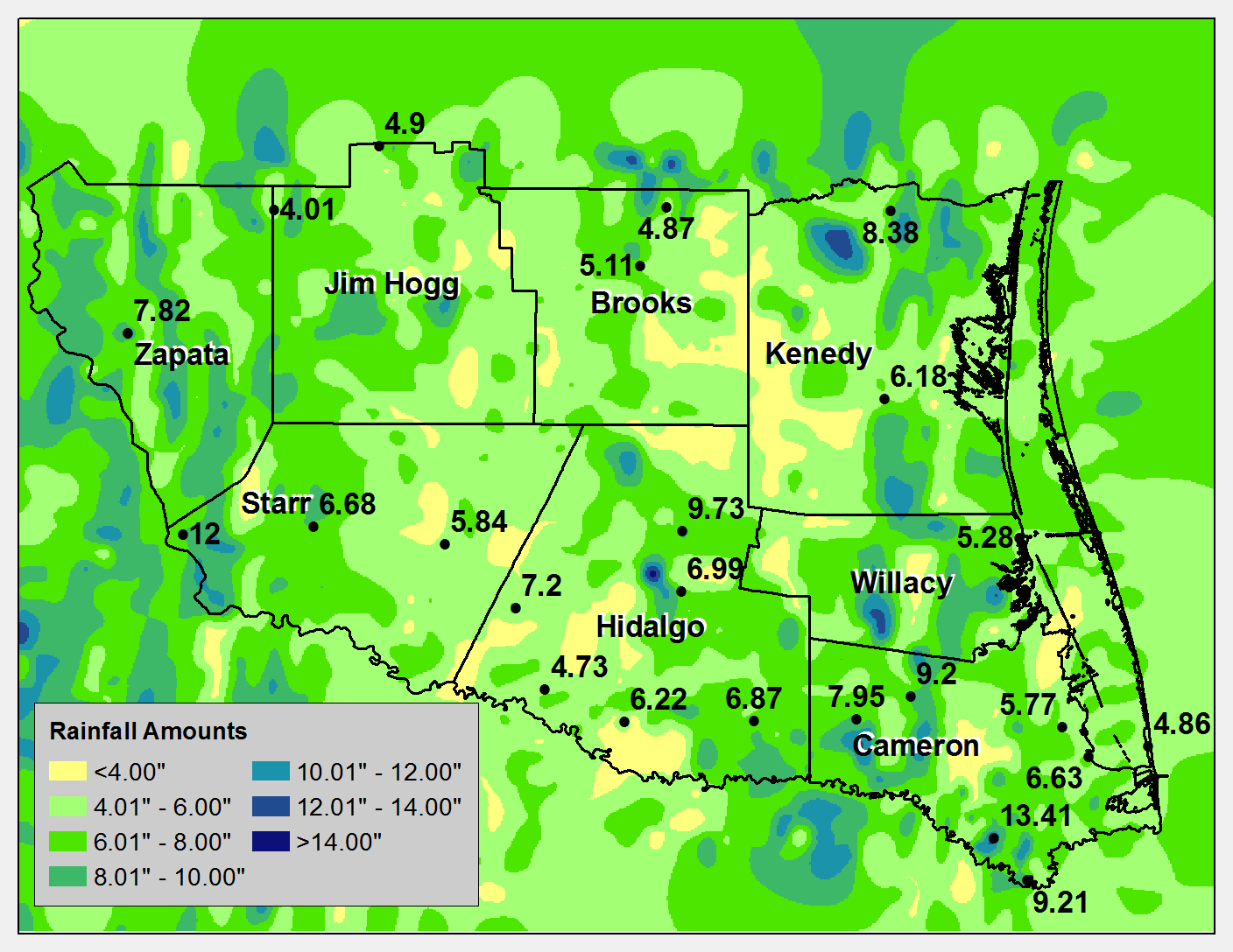
After another largely hot and dry summer, punctuated by occasional bursts of locally heavy rain, September 2013 finally brought a more typical atmospheric pattern to the Rio Grande Valley and Deep South Texas (bottom of page). The area wide totals, which generally ranged from 5 to 10, marked the wettest month since the record three year drought began after the similar soaking of September 2010. The rainy month was an appropriate "bookend" to the generally low rainfall 35 month period in between, but still well short of ending or relieving the long term drought condition. Lush, saturated green hues ruled a region where brown colors had dominated for so long.
Pattern of Hope
Persistent flow from the east and east–southeast high into the atmosphere tapped moisture from the southern Gulf and northern Caribbean region, which produced daily pockets of brief but locally heavy rainfall from the 2nd through the 12th. Tropical moisture which festered in the northwest Caribbean and Bay of Campeche region eventually organized into Hurricane Ingrid, whose feeder bands ultimately dropped between 2 and 4 inches across most of the Rio Grande Valley from the pre– dawn hours on September 16th through early September 17th. Additional scattered showers and storms continued through the 19th; on the 20th and early on the 21st, the remnants of eastern Pacific Tropical Storm Manuel, which moved along the west coast of Mexico and eventually made landfall in Sinaloa, were "picked up" by an upper level disturbance sliding from west to east across the southern Rockies. Torrential rains and flooding developed along the tail of tropical energy in Starr County, but the rain faded by daybreak on the 21st. The disturbance combined with non-tropical low pressure in the Gulf just east of the Valley to pull the autumn’s first cooler air into the region, and temporarily ended the rainy period. One last burst of heavy rains developed late on the 28th and early on the 29th across the Rio Grande Plains and Upper Valley, ensuring one of the wettest Septembers on record for locations along the Rio Grande from Roma (Starr) to San Ygnacio (Zapata).
Hurricane Ingrid: Welcome Assistance
On top of the welcome rainfall that dropped monthly averages for portions of Cameron (5 to 6 inches) County by the 13th, the developing wave in the Bay of Campeche became Tropical Storm Ingrid. Ingrid was a small–cored cyclone which never threatened the Rio Grande Valley with wind, but came from a larger envelope of circulation. Convergent outer bands kept isolated pockets of heavy rainfall, particularly near the coast, through the weekend of the 14th and 15th.
By daybreak on the 16th, persistent steadier rains arrived in the Lower Rio Grande Valley as Ingrid made landfall near La Pesca, Tamaulipas. A mid morning break would be followed by a return of rain coverage by mid to late afternoon as the convergent band reset, beginning in the Lower Valley and progressing to the mid and upper Valley by early evening. Intermittent torrential rains continued until a bit after midnight on the 17th from the Valley through the front range of the Sierra Madre Oriental. Rains tapered off as the remnant of Ingrid dissipated into the mountains southwest of Monterey early on the 17th. For the period from 7 AM on the 16th through 7 AM on the 17th, 1 to 3+ inches fell across the Rio Grande Valley into the Rio Grande Plains.
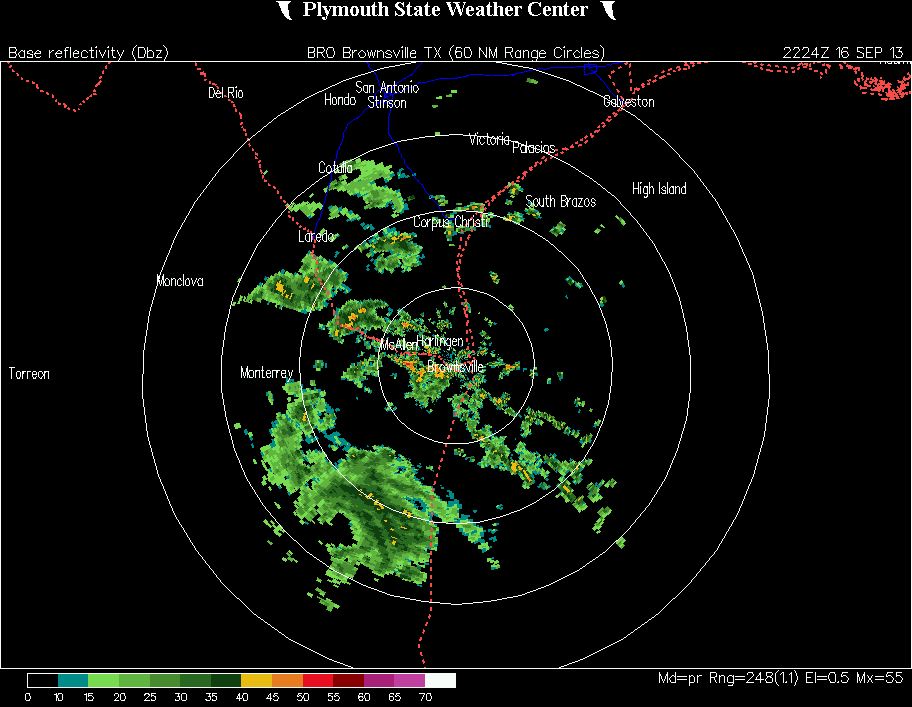
Loop of convergent band of locally heavy rainfall across the Rio Grande Valley associated with the remnant of Hurricane Ingrid. Ingrid’s leftover center is indicated by the black ‘hole’ among the green and yellow returns in central Tamaulipas (about 125 miles southwest of Brownsville). Click to enlarge. |
Hurricane Ingrid: Welcome Assistance(continued)
The National Weather Service Brownsville/Rio Grande Valley gives two thumbs up to our trusted local Emergency Management and Media partners, who participated and assisted communities in clearing debris and brush from drainage canals, ditches, sewers, and other infrastructure to ensure runoff flowed freely, in light of increasingly saturated soil and the lack of significant widespread rainfall throughout the summer. Anecdotal evidence suggested these efforts reduced heavy rainfall impacts to a mere nuisance. Pre positioning of pumps to known flood areas, such as Palmview (near Mission in Hidalgo County) kept the impacts in check. Despite the locally heavy rainfall, life threatening flooding was not observed in the Valley.
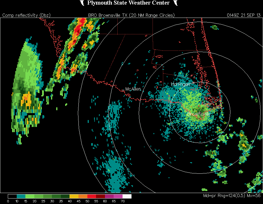
Loop of thin band of torrential rainfall across western Starr County during the evening of Friday, September 20th. Click to enlarge.
Tropical Storm Manuel: Arroyo Flooding in Starr
Remnant tropical moisture from Tropical Storm Manuel (eastern Pacific) and an upper level disturbance diving southeast from the southern Rockies met across west and central Texas and provided welcome rainfall to drought–starved portions of the state from the Big Bend Region through the Hill Country to southeast Texas. Much of this rainfall flowed into the Rio Grande between Presidio and Amistad Reservoir, as well as the Devils and Pecos Rivers which feed Amistad. As the combined system headed east, a thin band of torrential rain dumped an estimated 2 to more than 3 inches in a short period of time across northwestern Starr County at the headwaters of Arroyos Quiote and Los Morenos, among others. The rapid rain pushed water levels to or above bank full; flood waters temporarily overtopped U.S. 83 between Rio Grande City and Roma with up to 1 ½ feet of water forcing temporary road closures. Additional heavy rainfall in Rio Grande City reportedly reached into some properties, with other roads closed. This was the first significant individual flood event since the August 18–25 floods of 2008.
Last Licks: Thunderstorm System Socks Zapata, western Starr
The final week of September 2013 began with an October preview, featuring low humidity, light winds, and early morning temperatures in the upper 50s to mid 60s from the Ranchlands to the Lower Valley. By the weekend, the upper level high pressure ridge had edged into the central Gulf and Lower Mississippi Valley, and a brief return of atmospheric tropical moisture channeled from the Sierra Madre into central Texas. An upper level disturbance and fading cold front activated the moisture into numerous thunderstorms, some with small hail and gusty winds, from the Rio Grande Plains through the South Texas Brush Country and bending northeast through the Austin/San Antonio metropolitan region. Between 1 and 3 inches fell from southwest Starr County through western Zapata County; the rain would eliminate drought along the river by the start of October, and continue to increase water levels at Amistad and Falcon reservoir.
Surf’s Up!
For more than a week, swells generated by broad low pressure in the western and southwestern Gulf and enhanced by Hurricane Ingrid (14th through 16th) and a more concentrated Texas Gulf Low (21st through 23rd) kept surf high, with breakers estimated at 8 feet or higher at times, and pushed tides into the dunes on South Padre Island. Despite peak high tides for the month during each period, water never reached or breached the sea walls and caused no known flooding in Port Isabel or on the bay side of South Padre Island. A photo of the peak tide into the dune just before high tide on September 22nd is here.
|


