|
In Brief
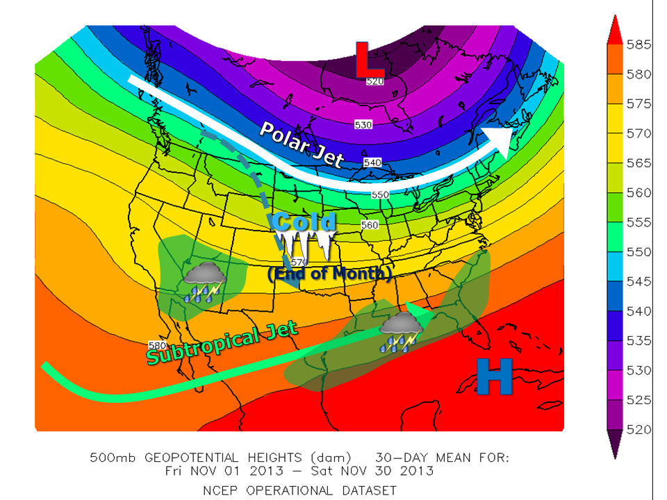
November 2013 was a weather roller–coaster for the Rio Grande Valley: A typical start was interrupted with locally heavy rainfall ahead of a cooling front on November 6th; some pockets in Cameron (Brownsville City) and Hidalgo (McCook Area northwest of McAllen) County received 3 to 4 times their monthly average rainfall in just a few hours! Another front chilled the region by mid–month, and temperatures seemed headed for a slightly below average trend before summer’s last gasp brought a week with temperatures 5 to 10°F above average from the 16th through 22nd. Then, the bottom dropped out, as the "winter’s" first modified arctic air mass descended on the Valley late on the 22nd. From late evening on the 22nd through Thanksgiving Day (28th), daily temperatures averaged 15 to 20°F below average, ensuring November 2013 would be the coolest month, compared to average, across the Valley since March 2010 – a 3 ½ year period where nearly every month was above the 1981–2010 long term average.
Stat Pack
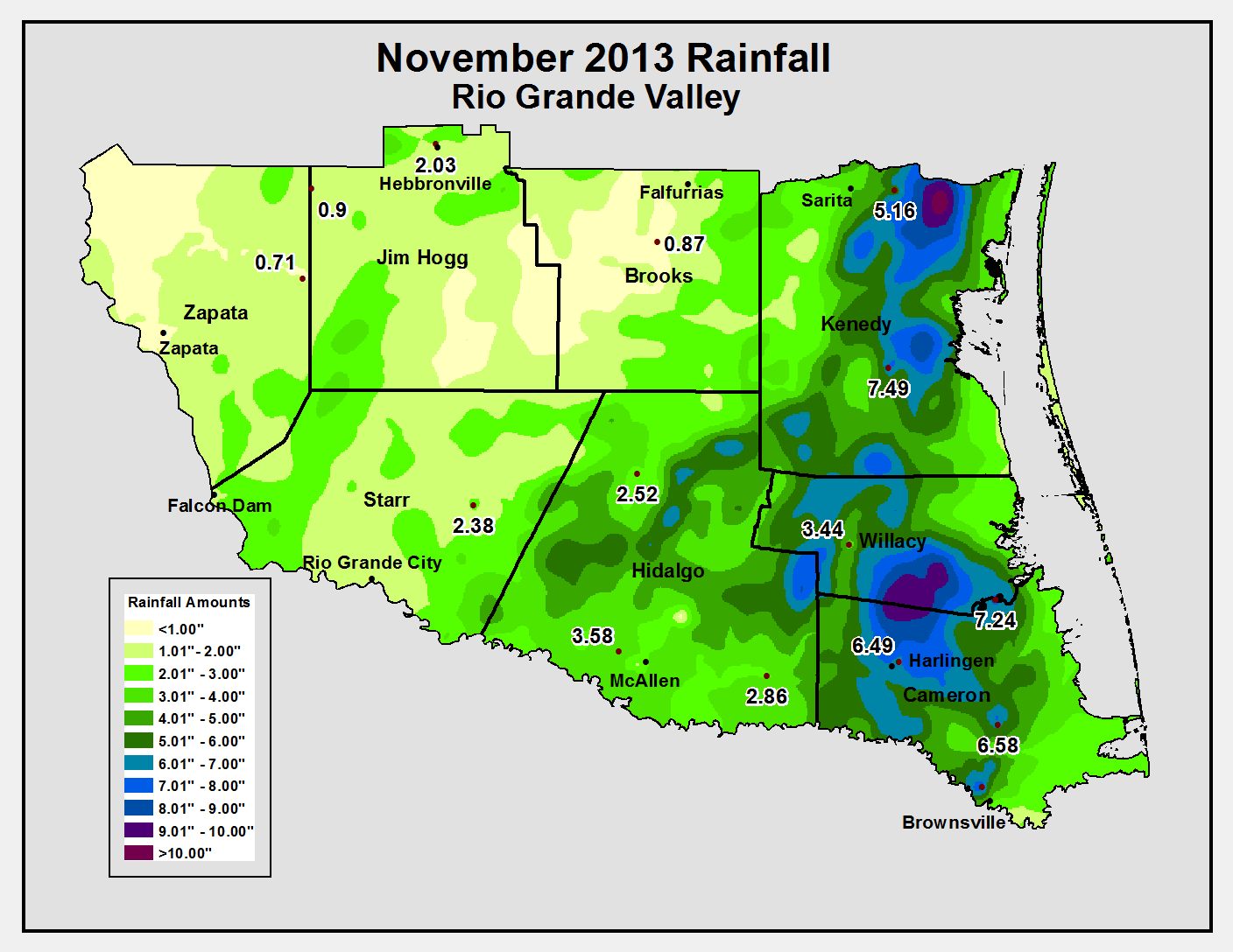
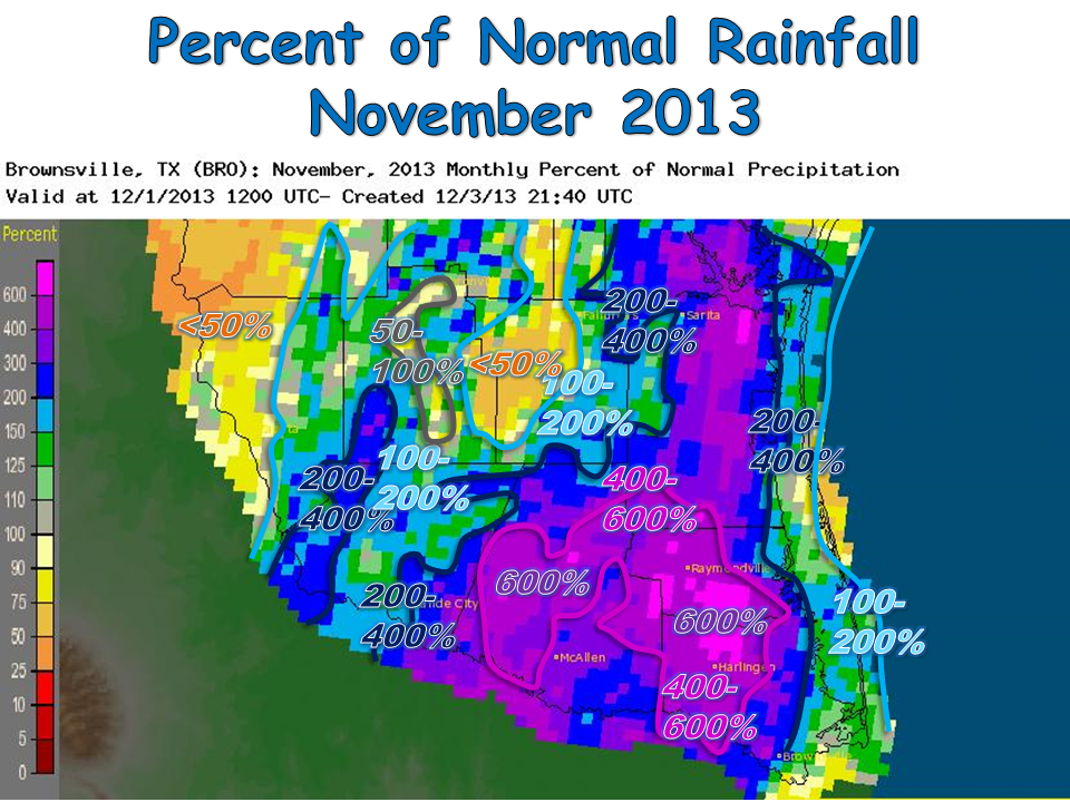
- Rainfall. Portions of Cameron and Willacy County ended up with more than 600% of average (below); nearly 8 inches fell near Harlingen and estimates above 8 inches were noted along the Cameron/Willacy County line near Sebastian.
- Drought Relief. The locally heavy rains combined with lower sun angle and plenty of clouds and lower temperatures after November 22nd allowed improvement by one or more categories by month’s end. Hidalgo County’s Severe (east) to Exceptional (southwest) condition moderated to Moderate (east) and Severe (west). Cameron County improved from Moderate/Severe to Abnormally Dry/Moderate. Some ranchland locations missed out on the action, including southern Jim Hogg/southwest Brooks County, as well as southeast Kenedy (King/Yturria Ranch area). Week to week drought archive data can be found here.
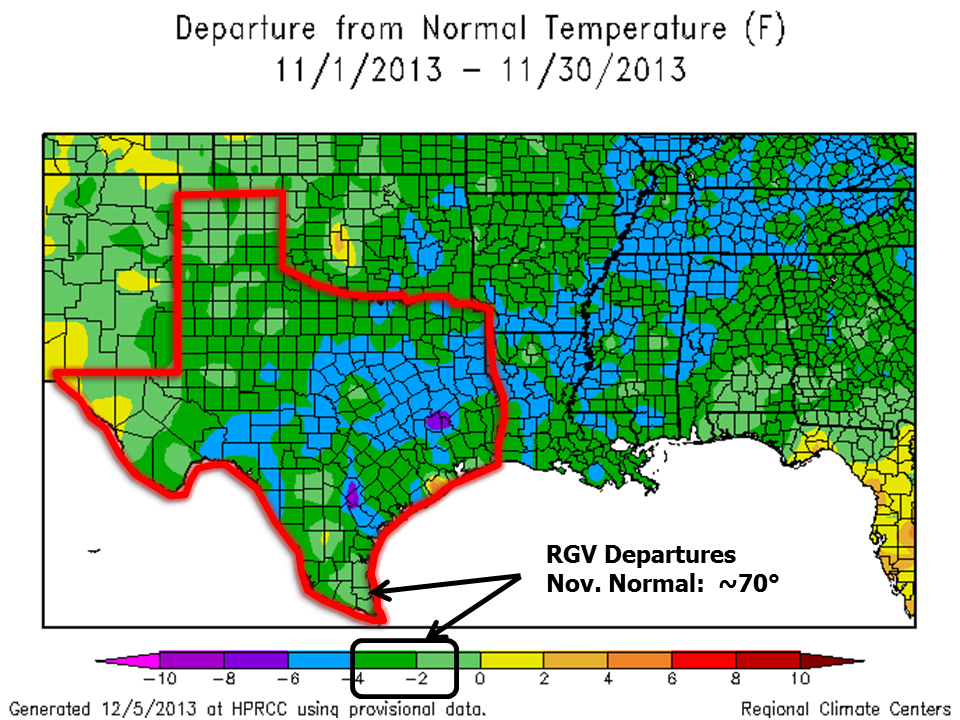
- Temperature. Monthly averages generally ranged from 1 to nearly 4 inches below the 1981–2010 benchmark (below, right). Harlingen/Valley Airport finished 3.9°F below its marker (64.5°F vs. 68.4°F); McAllen/Miller ended at 3.1° below average (66.3° vs. 69.4°F), and Brownsville/SPI International Airport was 2.5°F below (66.9°F vs. 69.4°F). The March 2010 departures were 3.7°,F 2.4°F and 2.6°F below their 1981–2010 benchmarks, respectively. As of this writing, December 2013 was headed toward similar, or lower, mid–month departures. The last time there were two substantial (2°F or more) below average months in a row? February and March, 2010.
November 22: Season Change, with a Bang
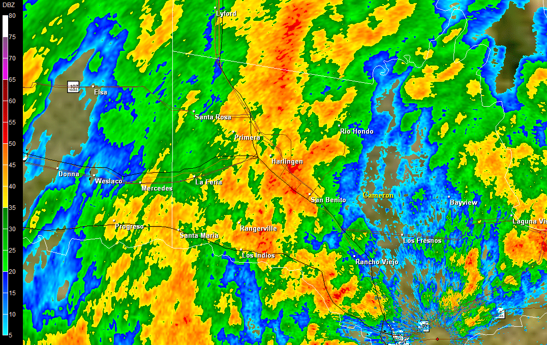
Modified polar air swept from western Canada through the eastern slopes of the Rockies on November 20th, and sliced through the northern half of Texas on the 21st, and slammed through the Rio Grande Valley on the 22nd. The shallow cold air mass provided the necessary “wedge” for sufficient mid and upper level atmospheric energy to override; as the air mass arrived into the heart of the last of summertime tropical heat and humidity, the added moisture aided initial thunderstorms just in time for the afternoon school bus and commute. As the front undercut the storms, temperatures crashed from the September-like upper 80s into the November-like upper 50s in little more than an hour. Enhanced convergence behind the initial burst of heavy rain produced prolonged moderate to heavy rainfall with embedded lightning well into the evening; by midnight, 3 to 6 inches had fallen across much of the Highway 77/Interstate 69E corridor.
|

Loop of 0.5° reflectivity across Cameron, Willacy, eastern Hidalgo County. Note the persistent heavy rain between San Benito and east Harlingen; more than 6 inches was reported in some areas.
November 22: Season Change, with a Bang (continued)
The heavy rains and modified polar chill slammed the door shut on the 2013 summer weather once and for all. Key impacts from the shift from summer to winter included the following:
- Active vertical motions just ahead of the front produced isolated thunderstorms with small hail, prior to the front’s arrival
- Gusty winds from the north in excess of 45 mph, combined with blinding rainfall, may have contributed to the following between 3 and 8 PM on November 22:
- An older live oak tree crashed on a home in Harlingen, and others fell on power lines on South Padre Island
- More than 3,000 local utility customers were without power
- A 16 foot pleasure craft took on water near the Brownsville ship channel a couple hours after the front arrived (6 PM Nov. 22). Three on board were rescued
- Several accidents on roads and highways in the Lower Valley
- The postponement of the big Sharyland/Harlingen football playoff game due to a foot or more of water on the field prior to scheduled kickoff
- Initial reports of possible localized flash flooding in Harlingen, including "trashcans floating down the street", where more than 6 inches fell within a 6 to 7 hour period between 3 and 10 PM
- Several inches of water washed into City Hall in Raymondville
- Temperatures were rooted to the 40s, with frequent wind chill temperatures between 35 and 40, for three days following the front. For the Valley, these three days (November 23–25) marked the first time since 1976 (November 28–30) that temperatures failed to reach 50 in November; in this case, from Harlingen to McAllen
- Surf temperatures at South Padre Island fell from 72° the morning of November 22 to 56° the morning of November 24, effectively ending the last of the summer "beach season"
Early notification of core partners in the media, emergency management, etc. may helped keep some safe. Despite the accidents, local newspapers followed NWS recommendations for people to be alert to nuisance urban flooding on the 22nd, more than a day earlier. Area shelters added additional beds a day in advance of the arrival of the cold front, which likely helped keep many from having to deal with the sharp temperature change and wet weather. We salute organizations who took proactive stances to help NWS Brownsville/Rio Grande Valley meet our core mission of protecting life and property.
|

