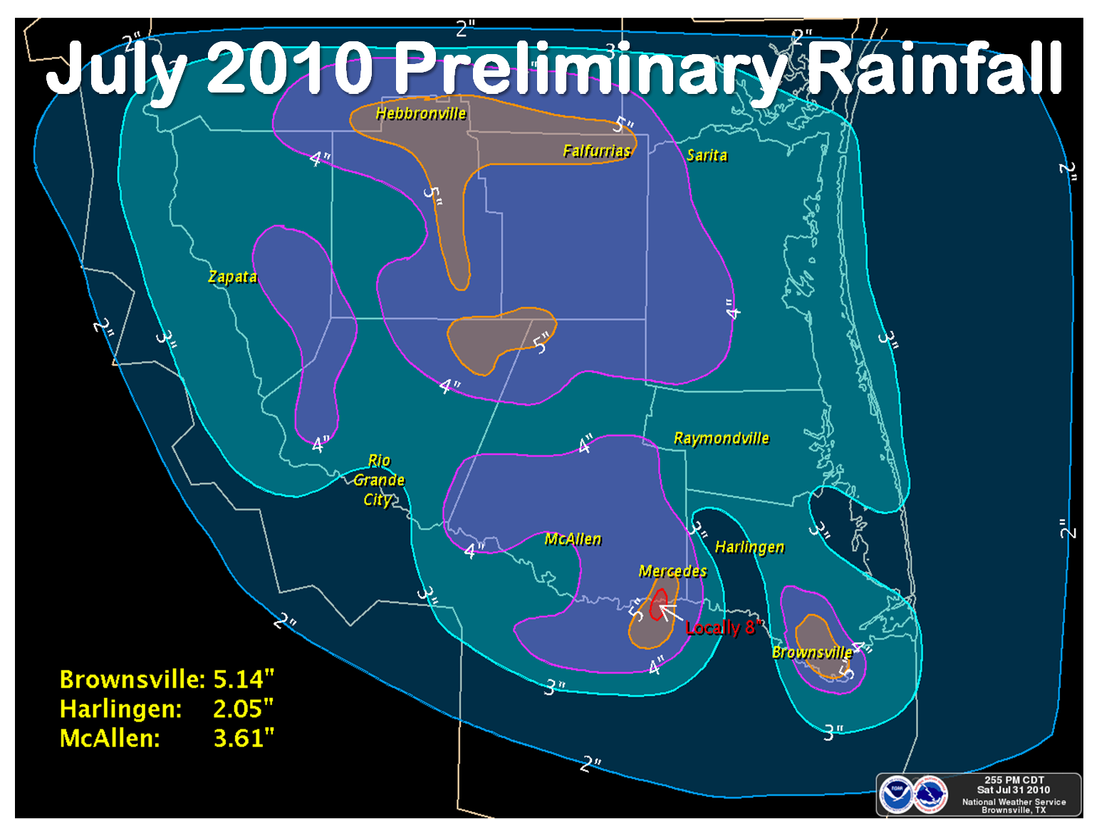
 Preliminary measured and estimated rainfall across Deep South Texas, July, 2010. From Famine to Feast? July 2010’s Normalcy in Stark Contrast to July 2009 Heat/Drought |
|
Overview A brief climate review for July 2010 follows. Additional rainfall information, links, and other data will be added before the end of the week
PUBLIC INFORMATION STATEMENT NATIONAL WEATHER SERVICE BROWNSVILLE TX 904 AM CDT SUN AUG 1 2010 ...JULY 2010 CLIMATE ROUNDUP FOR DEEP SOUTH TEXAS... RECORD DATES FOR EACH LOCATION ARE AS FOLLOWS: BROWNSVILLE RECORDS BEGAN 1878... HARLINGEN RECORDS BEGAN 1911... MCALLEN RECORDS BEGAN 1941... .BROWNSVILLE... THE AVERAGE TEMPERATURE IN BROWNSVILLE FOR JULY WAS 84.94 DEGREES...1.0 DEGREES ABOVE NORMAL. THIS IS TIED FOR THE 30TH WARMEST JULY ON RECORD FOR BROWNSVILLE. ONE RECORD HIGH MINIMUM TEMPERATURE WAS TIED ON THE 3RD. ONE RECORD LOW MAXIMUM TEMPERATURE WAS SET ON THE 28TH. BROWNSVILLE AIRPORT RECEIVED 5.14 INCHES OF RAIN IN JULY...3.37 INCHES ABOVE NORMAL. THIS IS THE 10TH WETTEST JULY IN BROWNSVILLE HISTORY. ONE RECORD DAILY RAINFALL WAS SET ON THE 8TH. .HARLINGEN... THE AVERAGE TEMPERATURE IN HARLINGEN FOR JULY WAS 83.79 DEGREES...0.6 DEGREES BELOW NORMAL. THIS IS THE 31ST COOLEST JULY ON RECORD. TWO RECORD HIGH MINIMUM TEMPERATURES WERE SET ON THE 3RD AND 14TH. ONE RECORD LOW MAXIMUM TEMPERATURE WAS SET ON THE 28TH. HARLINGEN AIRPORT RECEIVED 2.05 INCHES OF RAIN IN JULY...0.34 INCHES ABOVE NORMAL. THIS IS THE 35TH WETTEST JULY IN HARLINGEN. .MCALLEN... THE AVERAGE TEMPERATURE IN MCALLEN FOR JULY WAS 85.31 DEGREES...0.6 DEGREES BELOW NORMAL. THIS IS THE 34TH WARMEST AND 34TH COOLEST JULY ON RECORD FOR MCALLEN. THIS IS ALSO 7.5 DEGREES LOWER THAN THE RECORD SETTING AVERAGE TEMPERATURE RECORDED IN 2009. FOUR RECORD HIGH MINIMUM TEMPERATURES WERE SET ON THE 2ND...3RD...4TH AND 14TH. ONE RECORD LOW MAXIMUM TEMPERATURES WAS SET ON THE 28TH. MCALLEN AIRPORT RECEIVED 3.61 INCHES OF RAIN IN JULY...1.96 INCHES ABOVE NORMAL. THIS IS THE 8TH WETTEST JULY ON RECORD. ONE DAILY RECORD RAINFALL WAS RECORDED ON THE 28TH. RAINFALL WAS RECORDED IN MCALLEN ON 13 SEPARATE DAYS IN JULY. THIS SETS THE MONTHLY RECORD...BREAKING THE PREVIOUS RECORD OF 11 SET IN 1976...1999 AND 2007. FIVE OF THE 10 WETTEST MONTHS OF JULY IN MCALLEN HAVE OCCURRED SINCE 2005. MCALLEN HAS ALSO REACHED ITS YEARLY AVERAGE FOR PRECIPITATION.
|

