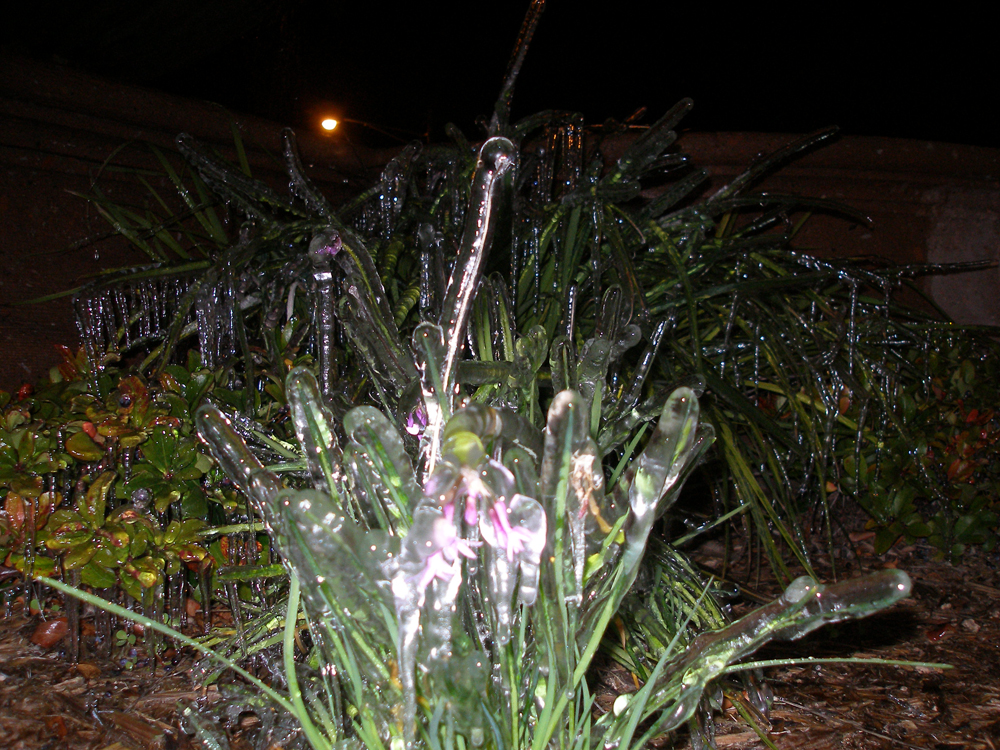
 Icicles form on grass and shrubs near a fountain in McAllen. Very dry air surrounding the fountain spray helped the ice form as ambient temperatures of the plants dropped below 32°F, even as air temperatures away from the fountain remained above 32°F. Photo courtesy of Alan Shoemaker. Hard Freeze(s) Cover Much of Valley Record Cold for Some Jan. 9th; Heavy Frost for Some Jan. 10th |
|
|
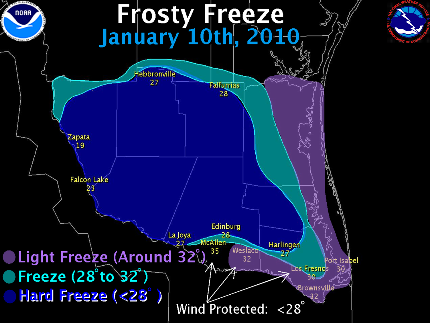
A blast of very cold Canadian air came sweeping down the Great Plains, migrating from the Yukon and Northwest Territories through Saskatchewan and Alberta Provinces, starting on January 6th. The high pressure cell, sourced near the Arctic Circle, brought sharply falling temperatures on January 7th, which would fall to near freezing by mid to late morning on January 8th before struggling to rise into the mid 30s to near 40 toward evening. The 8th would become one of the coldest "feeling" days in recent memory, as the combination of low temperatures and gusty north winds of 15 to 20 mph near the coast brought apparent temperature to 20 to 25°F for many. Patchy light sleet combined with the slate gray sky to make it look more like Canada than the Rio Grande Valley Evening clouds on the 8th allowed a gradual temperature fall, but conditions did not begin a steady drop until the clouds cleared from northwest to southeast through just after midnight. By daybreak, all of Deep South Texas, save for the immediate coast and urban/developed locations, sustained hard freeze conditions (above). Clear, Canadian–blue skies allowed some recovery in temperatures by afternoon, with highs reaching the upper 40s to around 50 under a continuing light to moderate north wind. By the night of the 9th, clear skies and lighter winds allowed temperatures to fall rapidly back into the 30s. After midnight, sheltered or wind protected locations plummeted into the upper teens to lower 20s, while locations with a continuing 4 to 8 mph northerly wind fell to or just below freezing for several hours. Higher relatively humidity allowed widespread frost to form, thickest in hollows and other low lying areas. 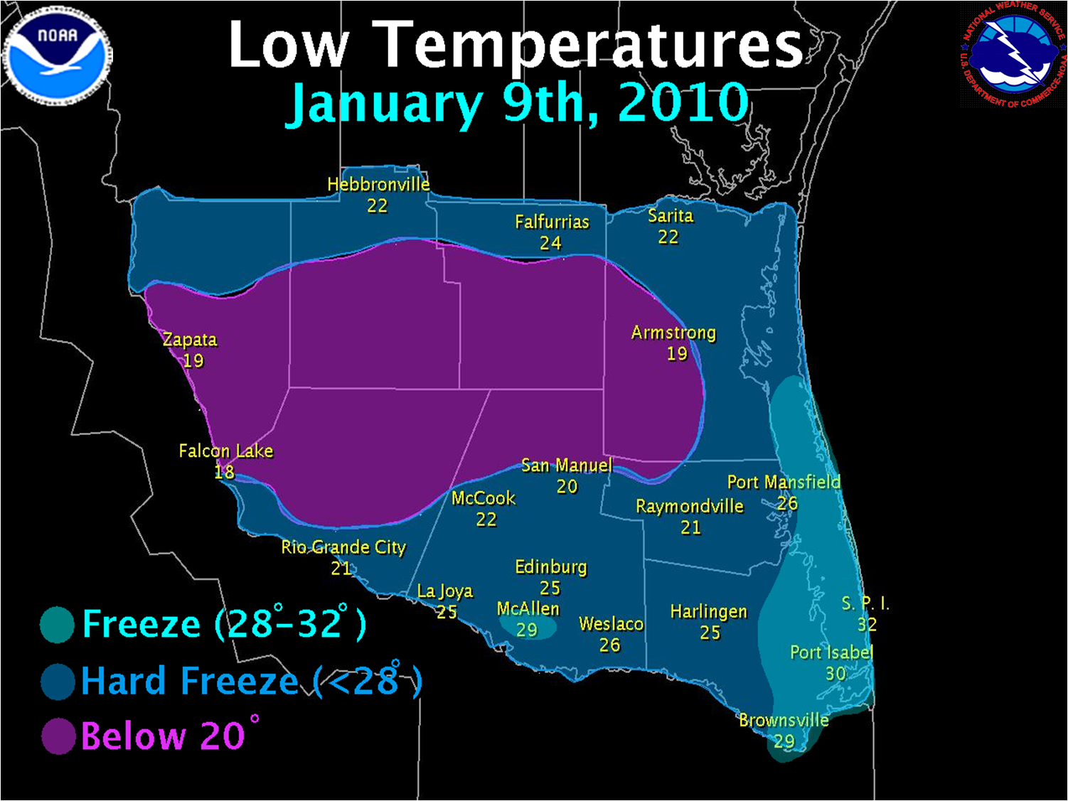
A table of low temperatures, duration of temperatures at or below freezing, and duration of a hard freeze follows: PUBLIC INFORMATION STATEMENT...UPDATED NATIONAL WEATHER SERVICE BROWNSVILLE TX 1259 PM CST MON JAN 11 2010 ...SUMMARY OF FREEZING TEMPERATURES ACROSS DEEP SOUTH TEXAS... THE RECENT INTRUSION OF COLD ARCTIC AIR AFFECTED DEEP SOUTH TEXAS FRIDAY AND SATURDAY NIGHTS. NUMEROUS LOCATIONS RECORDED LOW TEMPERATURES WELL INTO THE 20S AND EVEN UPPER TEENS FOR SEVERAL HOURS BOTH NIGHTS. THE FOLLOWING ARE LOW TEMPERATURES FOR FRIDAY AND SATURDAY NIGHTS. NOTE THAT ASOS AND AWOS TEMPERATURE SENSORS ARE GENERALLY LOCATED 10 METERS OR 33 FEET ABOVE THE SURFACE, RAWS AND CO-OP SITE TEMPERATURE SENSORS ARE GENERALLY 1 1/2 TO 2 METERS OR 5 TO 6 FEET ABOVE THE SURFACE AND CWOP SITE SENSORS GENERALLY VARY FROM 5 TO 15 FEET. FRIDAY NIGHT AIRPORTS/ASOS/RAWS LOW TEMPERATURE|DURATION 32 OR LESS|DURATION <28 ==================================================================== FALCON LAKE 18 10 1/2 HRS 9 1/2 HRS SANTA ANA NWR 19 8 HRS 6 HRS ZAPATA 19 13 HRS 9 1/2 HRS LINN-SAN MANUEL 20 10 1/2 HRS 7 1/2 HRS HEBBRONVILLE 22 13 1/2 HRS 9 HRS FALFURRIAS 24 9 HRS 5 HRS EDINBURG 25 9 HRS 5 HRS HARLINGEN 25** 8 1/2 HRS 6 HRS WESLACO 26 8 HRS 5 HRS BROWNSVILLE 29* 6 HRS* 0 HRS LAGUNA ATASCOSA 28 5 1/2 HRS 0 HRS MCALLEN 29 4 1/2 HRS 0 HRS PORT ISABEL-CAMERON COUNTY 30 7 1/2 HRS 0 HRS NWS COOPERATIVE OBSERVERS ==================================================================== ARMSTRONG 19 FALFURRIAS 20 SAN MANUEL 20 RAYMONDVILLE 21 RIO GRANDE CITY 21 FALCON DAM 22 MCCOOK 22 SARITA 22 HEBBRONVILLE 24 LA JOYA 25 HARLINGEN 26 PORT MANSFIELD 26 EDINBURG 28 MCALLEN 28 MERCEDES 28 ISLA BLANCA/S. PADRE ISLAND 32 APRS/WXNET/CWOP/OTHER ==================================================================== DW0663 ZAPATA 22 13 1/2 HRS 9 1/2 HRS CW3172 MISSION 23 9 1/2 HRS 6 1/2 HRS DW1157 LA JOYA 25 8 1/2 HRS* 4 1/2 HRS* CW3617 MCALLEN 27 7 1/2 HRS* 3 HRS* KC5WBG WESLACO 27 7 HRS 1 HRS CW8690 LOS FRESNOS 28 7 HRS 0 HRS KB40B MISSION 29 8 HRS* N/A HRS DW1996 LAGUNA VISTA 31 6 HRS 0 HRS SATURDAY NIGHT AIRPORTS/ASOS/RAWS LOW TEMPERATURE|DURATION 32 OR LESS|DURATION <28 ==================================================================== ZAPATA 19 10 1/2 HRS 7 1/2 HRS SANTA ANA NWR 20 11 1/2 HRS 11 HRS LINN-SAN MANUEL 23 10 1/2 HRS 8 1/2 HRS FALCON LAKE 24 10 1/2 HRS 6 1/2 HRS HARLINGEN 27 10 HRS N/A HRS HEBBRONVILLE 27 11 1/2 HRS 2 1/2 HRS EDINBURG 28 7 1/2 HRS 0 HRS FALFURRIAS 28 9 1/2 HRS 0 HRS PORT ISABEL-CAMERON CO 30 1/2 HRS 0 HRS LAGUNA ATASCOSA 31 3 1/2 HRS 0 HRS BROWNSVILLE 32 1/2 HRS 0 HRS WESLACO 32 1/2 HRS 0 HRS MCALLEN 35 0 HRS 0 HRS APRS/WXNET/CWOP/OTHER ==================================================================== DW0663 ZAPATA 25 9 1/2 HRS 4 HRS DW1157 LA JOYA 27 6 1/2 HRS 1/2 HRS CW3172 MISSION 28 8 1/2 HRS 0 HRS CW8690 LOS FRESNOS 30 3 1/2 HRS 0 HRS CW3617 MCALLEN 32 3 HRS 0 HRS KB40B MISSION 32 3 1/2 HRS 0 HRS KC5WBG WESLACO 32 <1/2 HRS 0 HRS DW1996 LAGUNA VISTA 34 0 HRS 0 HRS *DENOTES ESTIMATED DATA **DENOTES NEW RECORD LOW TEMPERATURE
|
|
 |
|

