|
Overview
As the 2010 Atlantic Hurricane Season winds to a close, most everyone in North America is breathing a sigh of relief. While the number of cyclones, hurricanes, and major hurricanes was enough to put fear into coastal residents from the Virgin Islands to the Canadian Maritimes, steering patterns and other fortunate ocean/atmosphere interactions, not to mention dumb luck, kept some of the potentially devastating storms at sea, literally and figuratively. Media coverage will likely focus on a busy season that was missing in action; indeed, major population centers around the United States Gulf and Eastern Seaboard saw virtually no impact, save for a scraping along the Mid Atlantic and Northeast U.S. coastline by Hurricane Earl in late August.
While these areas were spared, the same cannot be said for the coast of eastern Mexico through the Yucatan Peninsula, including our own border region of the Rio Grande Valley. Five cyclones, starting with Alex at the end of June and ending with Richard (Belize into extreme northeast Honduras), affected this region, leaving more than $7 billion (USD) in damage and dozens of lives lost. Karl (September) was likely the most damaging wind storm, a tightly wrapped Category 3 hurricane which rolled through Veracruz, México. Rainfall from Alex and Tropical Depression Number 2 likely added up to more than 50 inches in the northern Sierra Madre and foothills which drain into the Rio Grande, causing massive flooding along unprotected portions of the river from Laredo to Rio Grande City and Los Ebanos, and requiring full use of the Lower Rio Grande Flood Control Project for the first time since 1988.
In addition to Alex and Tropical Depression Number 2, fast developing and fast moving Tropical Storm Hermine made a direct hit on Cameron and Willacy Counties, leaving millions of dollars in wind damage behind.
Fast Facts
- NOAA’s May 2010 Hurricane Outlook forecast 14 to 23 named storms, 8 to 14 hurricanes, 3 to 7 major hurricanes, and an Accumulated Cyclone Energy (ACE) Index Range of 155 percent to 275 percent of average. The preliminary results so far:
- 19 named storms.
- 12 hurricanes.
- 5 major hurricanes.
- ACE range: 190 percent of average
- The combination of high upper oceanic heat content across much of the basin, and a rapidly developing La Niña in the eastern tropical Pacific – known to sharply reduce upper level wind shear, were key reasons for the large number of cyclones.
- The strength of Alex so early (late June) notwithstanding, the season got off to the typical "slow" start; Danielle, the season’s second named hurricane did not reach status until August 23rd. From then until October 31st, however, 10 more cyclones would achieve hurricane status in the next 70 days!
- Teleconnections, or atmospheric "puzzle pieces" which help dictate intraseasonal weather patterns, played a role in storm formation and movement. The following situations were apparant during the peak of the season:
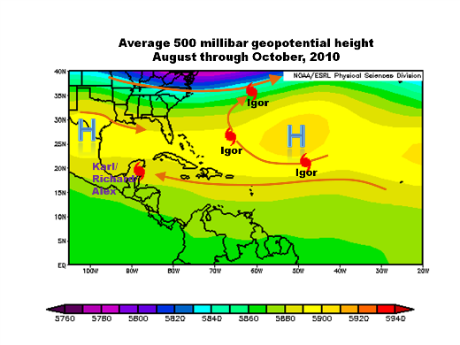
- Gap between the broad central Atlantic subtropical high pressure ridge and another ridge across the southern Great Plains during the peak of the season (below) allowed the following: Southerly flow around the core of the Atlantic ridge ("H") began recurvature (Igor, Danielle, Earl)
- Westerly flow north of 35°N latitude allowed storms to recurve and accelerate away from U.S. East Coast
- Cyclones forming deep in the western Caribbean able to move to the west or northwest and recurve little, held by location of weaker, secondary ridge in southern Plains (Alex, Karl, Richard)
- The North Atlantic and Arctic Oscillation remained in a weak negative phase, which may have help maintain the atmospheric pattern described above.
- The 2010 season is proof positive why we don’t "do" seasonal landfall predictions. As stated on the NOAA Hurricane Season Outlook: "NOAA does not make seasonal hurricane landfall predictions. Hurricane landfalls are largely determined by the weather patterns in place as the hurricane approaches, which are only predictable when the storm is within several days of making landfall."

Above: General steering patterns for the peak of the 2010 Hurricane Season.
The following table summarizes the 2010 Atlantic Hurricane Season.
Preliminary 2010 Hurricane Season Statistics
| Name |
Peak Category |
Dates |
Peak Wind (mph) |
MInimum Pressure (mb) |
ACE |
| Hurricane Alex |
2 |
June 25 - July 2 |
109 |
946 |
6.78 |
| Tropical Depression 2 |
|
July 8 - 9 |
35 |
1005 |
|
| Topical Storm Bonnie |
|
July 22 - 24 |
40 |
1007 |
0.368 |
| Tropical Storm Colin |
|
August 2 - 8 |
60 |
1005 |
1.87 |
| Tropical Depression 5 |
|
August 10 - 11 |
35 |
1007 |
|
| Hurricane Danielle |
4 |
August 21 - 30 |
135 |
942 |
21.8 |
| Hurricane Earl |
4 |
August 25 - September 4 |
145 |
928 |
27.8 |
| Tropical Storm Fiona |
|
August 30 - September 4 |
65 |
998 |
3.08 |
| Tropical Storm Gaston |
|
September 1 - 2 |
40 |
1005 |
0.245 |
| Tropical Storm Hermine |
|
September 5 - 9 |
70 |
989 |
1.27 |
| Hurricane Igor |
4 |
September 8 - 21 |
155 |
925 |
42.4 |
| Hurricane Julia |
4 |
September 12 - 20 |
140 |
948 |
14.2 |
| Hurricane Karl |
3 |
September 14 - 18 |
120 |
956 |
5.8 |
| Hurricane Lisa |
1 |
September 20 - 26 |
85 |
982 |
4.05 |
| Tropical Storm Matthew |
|
September 23 - 26 |
60 |
998 |
1.38 |
| Tropical Storm Nicole |
|
September 28 - 29 |
40 |
996 |
0.123 |
| Hurricane Otto |
1 |
October 6 - 10 |
85 |
976 |
4.43 |
| Hurricane Paula |
2 |
October 11 - 15 |
100 |
981 |
6.59 |
| Hurricane Richard |
1 |
October 20 - 26 |
90 |
981 |
4.56 |
| Hurricane Shary |
1 |
October 28 - 30 |
75 |
989 |
1.88 |
| Hurricane Tomas |
2 |
October 29 - November 7 |
100 |
982 |
10.9 |
Orange and bold rows indicate cyclones that directly impacted the Rio Grande Valley. Dates listed indicate the time the cyclone was deemed tropical, including initial depression stage. Total preliminary ACE was 159.6, which is 66.1 points above the 1951 to 2010 average of 93.5.
For final details on the 2010 Atlantic Hurricane Season, check the National Hurricane Center’s Atlantic Season Archive.
|

