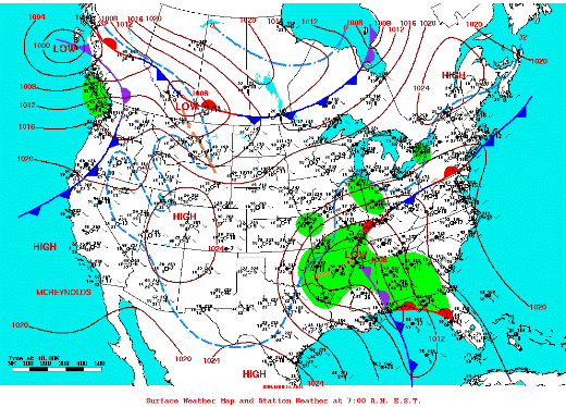
Daily Weather Map, March 21st 2010. Canadian High pressure system extended from Colorado and Utah southeast into Deep South Texas, with cold air flowing in between departing storm in Arkansas.
The Calendar Said Spring...
But it Sure Felt Like Winter!
Canadian High Pressure Brings Wind, Chill, Record Cold on March 21, 2010 |
|
Overview
Yet another vigorous storm system riding a still–active subtropical jet brought near blizzard conditions to Oklahoma and the Texas Panhandle on Saturday, March 20th, and sent a strong cold front barrelling through the RGV and Deep into northern Mexico, abruptly ending a nice spell of March weather for Spring Breakers and other outdoor enthusiasts by early afternoon. Temperatures tumbled from the 70s into the upper 50s and lower 60s, as north winds surged over 30 mph with gusts as high as 50 mph immediately behind the front near the Lower Texas Coast. Low clouds behind the front moved away just before sunset on the 20th, setting the stage for locally record cold by sunrise on the 21st. During the evening and well into the overnight of the 20th, wind chill values, normally not a consideration for residents and visitors this late into the season, dropped into the 30s. By daybreak on the 21st, nearly all of Deep South Texas had plunged into the 30s, setting near records (Table 1, below) at many stations.
An azure blue afternoon on the 21st combined with the warming late March sunshine to return temperatures back into the 70s. Very low humidity made for a comfortable day despite a fresh northwest breeze, but that same dry air allowed overnight temperatures to tumble quickly into the 40s and 50s by around midnight, bottoming out in the 30s and 40s by daybreak on the 22nd.
Table 1: Unofficial Minimum Temperatures, March 21, 2010
| Location (since year) |
County |
Low |
Pvs. Record |
Year |
|
Brownsville/SPI Int'l Arpt (1878)
|
Cameron
|
37
|
40
|
1915
|
|
Harlingen/Cooperative† (1911)
|
Cameron
|
40 (36 arpt*)
|
37
|
1965
|
|
McAllen/Miller Arpt (1961)
|
Hidalgo
|
40
|
45
|
1961
|
|
McAllen/Cooperative (1941)
|
Hidalgo
|
N/A
|
37
|
1965
|
|
Falcon Dam (1962)
|
Zapata
|
36
|
36
|
1965
|
|
Falfurrias (1907)
|
Brooks
|
34
|
33
|
1965
|
|
Hebbronville (1905)
|
Jim Hogg
|
35
|
30
|
1965
|
|
Mercedes (1914)
|
Hidalgo
|
39
|
39
|
1915
|
|
Port Mansfield (1958)
|
Willacy
|
37
|
40
|
1965
|
|
Raymondville (1913)
|
Cameron
|
36
|
34
|
1965
|
|
Rio Grande City (1897)
|
Starr
|
39
|
35
|
1986
|
|
Sarita 7 E‡ (1910)
|
Kenedy
|
32
|
37
|
unkn
|
|
Armstrong
|
Kenedy
|
31
|
|
|
Table 2: Unofficial Minimum Temperatures, March 22, 2010
| Location (since year) |
County |
Low |
Pvs. Record |
Year |
|
Brownsville/SPI Int'l Arpt (1878)
|
Cameron
|
43
|
38
|
1989
|
|
Harlingen/Cooperative† (1911)
|
Cameron
|
41 (37 arpt*)
|
39
|
1989
|
|
McAllen/Miller Arpt (1961)
|
Hidalgo
|
44
|
39
|
1989
|
|
McAllen/Cooperative (1941)
|
Hidalgo
|
47
|
39
|
1989
|
|
Falcon Dam (1962)
|
Zapata
|
37
|
34
|
1968
|
|
Falfurrias (1907)
|
Brooks
|
32
|
31
|
1915
|
|
Hebbronville (1905)
|
Jim Hogg
|
35
|
32
|
1989
|
|
Mercedes (1914)
|
Hidalgo
|
38
|
42
|
1943
|
|
Port Mansfield (1958)
|
Willacy
|
36
|
37
|
1989
|
|
Raymondville (1913)
|
Cameron
|
36
|
37
|
1989
|
|
Rio Grande City (1897)
|
Starr
|
36
|
36
|
1970
|
|
Sarita 7 E‡ (1910)
|
Kenedy
|
32
|
39
|
unkn
|
|
Armstrong
|
Kenedy
|
33
|
|
|
*Minimum of Record Taken at Airport
†Cooperative location period of record: 1911 through present.
‡Year of Record Not Available.
Record low table cells in cyan.
Tied records in green.
Please note that cooperative locations record daily low temperatures early in the morning, normally between 7 and 8 AM Local Time. Thus, it is possible that some values for March 22nd occurred on March 21st, immediately after the minimum was recorded.
|


