Brownsville/Rio Grande Valley, TX
Weather Forecast Office
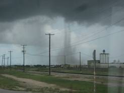 Photograph of Landspout several miles east of the Brownsville Shrimp Basin, a little after noon on August 12, 2010. Landspout, Ho! Weak Convergence along Sea Breeze Aids Formation |
|
The development of the late morning and early afternoon Lower Texas Gulf Coast sea breeze helped percolate showers just after noon on August 12th 2010 near the Cameron County coast toward Port Isabel. Sometime between noon and 1215 pm CST, a landspout developed approximately 5 miles southwest of Port Isabel, across open sand flats. No damage was reported; however, there were numerous eyewitnesses, since the event occurred along well traveled State Highway 48 between Port Isabel and the Brownsville Shrimp Basin during the middle of a summer day. More information will be provided on this site, including local radar and other observational data, pending a quick case study investigation during the next week or so. Check back here for details! |
CURRENT HAZARDS
Daily Briefing (National)
Outlooks
Severe Weather Text
Local Storm Report
Submit a Storm Report
CURRENT CONDITIONS
Surface Observations (map)
Text Observations
Satellite
Rivers and Lakes
Observed Precip - RGV
Tides and Currents
CoCoRaHS Texas
FORECASTS
Forecaster's Discussion
Graphical
Hourly View
Activity Planner
Marine
South Padre Tides
Wave Prediction
Beach
Surf
Fire Weather
Aviation
Tropical
Winter Storm Severity Index
Model Guidance
US Dept of Commerce
National Oceanic and Atmospheric Administration
National Weather Service
Brownsville/Rio Grande Valley, TX
20 S. Vermillion Avenue
Brownsville, TX 78521
956-504-1432 (8 AM to 430 PM Mon-Fri)
Comments? Questions? Please Contact Us.

