Preliminary Rainfall, August 28 through September 2 2009
| Location |
County |
Rainfall |
|
2.2 SW Palm Valley
|
Cameron
|
3.10
|
|
Rancho Viejo
|
Cameron
|
3.08
|
|
Harlingen 4.7 WSW
|
Cameron
|
3.03
|
|
Santa Ana/Lower Rio Grande Valley
|
Hidalgo
|
3.00
|
|
Harlingen 4.3 WSW
|
Cameron
|
2.73
|
|
Hebbronville
|
Jim Hogg
|
2.64
|
|
Bayview/Cameron County Airport
|
Cameron
|
2.41
|
|
Harlingen/Cooperative
|
Cameron
|
2.22
|
|
Harlingen 2.6 ESE
|
Cameron
|
2.12
|
|
Harlingen/Valley Airport
|
Cameron
|
1.61
|
|
Falfurrias
|
Brooks
|
1.56*
|
|
South Padre Island
|
Cameron
|
1.55
|
|
Los Fresnos
|
Cameron
|
1.33
|
|
McAllen/Miller
|
Hidalgo
|
1.19
|
|
Brownsville 2.2 W
|
Cameron
|
1.18
|
|
McAllen/Cooperative
|
Hidalgo
|
1.14
|
|
Brownsville SPI International Airport
|
Cameron
|
1.14
|
|
Falcon Lake
|
Starr
|
1.04
|
|
Rio Grande City
|
Starr
|
1.04
|
|
Rio Hondo 9.4 NE
|
Cameron
|
1.04
|
|
Armstrong
|
Kenedy
|
0.81
|
|
Brownsville 4.5 NNW
|
Cameron
|
0.71
|
|
Falcon Lake
|
Starr
|
0.61
|
|
Port Mansfield
|
Willacy
|
0.46
|
|
Sarita
|
Kenedy
|
0.45
|
Overview
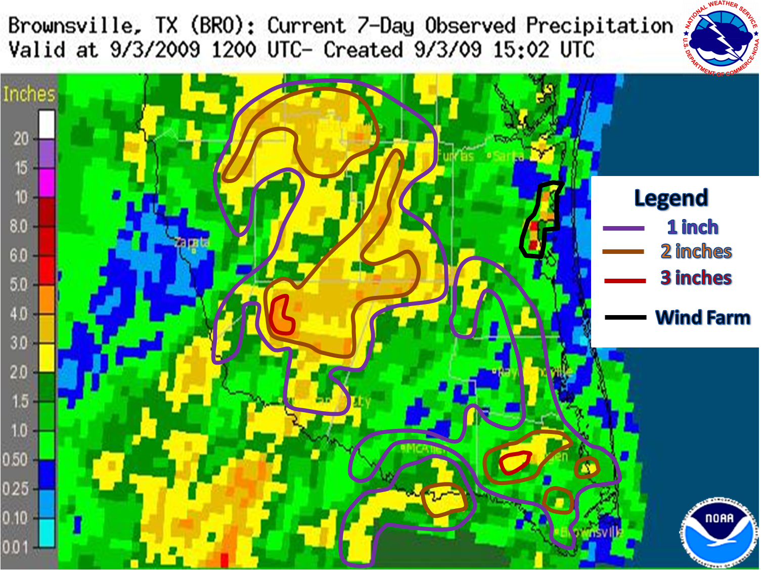
Those liquid drops from the sky are no lie. Indeed, like manna from heaven, some quenching and drenching rains have finally developed across Deep South Texas and the Lower Rio Grande Valley to end a record setting hot and dry summer (June through August) and ease the region into September. Between August 28th and September 2nd, 2009, thunderstorms dropped measured and estimated 1 to 3 inches across portions of the lower RGV, and a large pocket of 2 to 3 inches of rain in parts of Starr, Brooks, and Jim Hogg County. The rain, accomapanied by abundant cloudiness, has not only crushed the triple–digit heat wave, but held daytime temperatures in the 80s in many spots on August 31st. Temperatures rebounded to between 90 and 95 degrees on September 1st and 2nd, but were cut down by scattered to numerous afternoon thunderstorms or associated outflows. These lower temperatures brought an end to the prolonged period of above average readings, which in many cases lasted more than 65 days!
Sunshine and warmer temperatures returned to close the week before Labor Day. However, the combination of the earlier rains, light winds, and lenghtening nights helped return morning dew to the region, and kept afternoon temperatures fairly close to seasonal averages.
Pattern Matters
Subtle changes to the general summer pattern created large difference in the weather on the ground. The most significant difference was the development of a subtropical jet, located underneath an upper ridge that continued across the Four Corners region of the U.S. A weak longwave upper level trough, or disturbance, settled in near the Baja peninsula during the weekend of August 29th and 30th, with energy from the disturbance propagating eastward, across northern Mexico and eventually Deep South Texas. This energy combined with a weak low level trough to add tropical moisture from the lower levels to the higher level moisture supplied by the subtropical jet, seeding the atmosphere and setting the stage for increased rain potential. Smaller disturbances ejecting east from the larger system continued to produce abundant multi layered clouds, as well as times of showers and thunderstorms, through September 2nd. The strengthening four corners ridge eventually brought enough north to northwest flow into South Texas to push the deeper moisture southward into north central Mexico, bringing the aforementioned drier air back to Deep South Texas and the Rio Grande Valley.
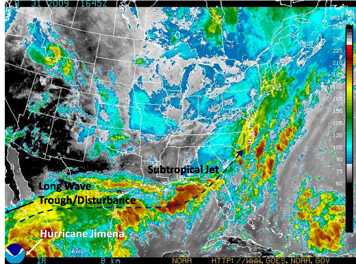
Infrared satellite image showing deep moisture flowing along the subtropical jet (dark blue arrow). Some moisture from eastern Pacific Hurricane Jimena was feeding into the system. |

