 From Blizzard to Blowtorch Texas’ Freaky Friday, March 27, 2009 |
|||||||||||||||||||||||||||||||||||||||||||||||||||||||||||||||||||||||||||||||||||||||||||
|
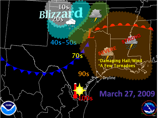
Early Spring in Texas often features weather extremes, a factor of the state’s location between the semi tropical Gulf of America, the mountains of northeast Mexico, the Great Plains, and the Mississippi Valley. A variety of weather conditions can result, ranging from Panhandle snows to southeast Texas hailstorms. March 27th, 2009, truly defined Texas weather extremes. In the Panhandle, not only did it snow, but a bona fide blizzard occurred, with a combination of frigid temperatures hovering near 20°F, sustained winds between 25 and 35 mph gusting near 50 mph, and heavy falling snow creating near whiteout conditions. When all was said and done, measured and estimated snowfall ranged to a foot or more, with drifts in some areas exceeding 12 feet! For a summary of the March 27th Panhandle Blizzard, click here. While a blizzard raged in the panhandle, severe thunderstorms, producing hail in excess of 2 inches, a few tornadoes, and damaging wind gusts, plowed across southeast Texas toward the upper Texas coast, in very unstable air ahead of a dryline and southeast of developing low pressure moving across northeast Texas. Farther west, behind the dryline and ahead of the front, northwest winds gusted in excess of 40 mph in spots as humidity fell to critical values, increasing the threat for explosive wildfire growth and spread. For the Rio Grande Valley, temperatures soared above 100°F as gusty northwest winds compressed the air flowing from higher terrain toward the coast, heating the surface toward daily records. Meteorology |
RGV High temperatures (column 2), previous record/year (columns 3 and 4), and new record (yes or no, column 5).
* Record recalulated for calendar day.
** Data incomplete. Effect on the Rio Grande Valley A warm and slightly breezy evening was followed by an hour or so of windy weather, generally between 10 PM and 1 AM, when the actual cool front slammed through. North winds 25 to near 30 mph with gusts of 40 mph or higher in some spots accompanied the front, along with a band of clouds and some sprinkles. Marine conditions deteriorated immediately, with frequent gale force gusts and seas briefly building over 12 feet very early on the 28th. Conditions gradually improved after sunrise, and by afternoon on the 28th, chamber of commerce weather had returned. |
||||||||||||||||||||||||||||||||||||||||||||||||||||||||||||||||||||||||||||||||||||||||||
 |
|||||||||||||||||||||||||||||||||||||||||||||||||||||||||||||||||||||||||||||||||||||||||||

