|
Quick Review
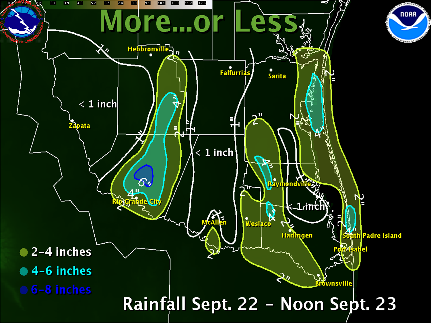
An approaching surface front plowing into continued near–record heat and humidity, triggered numerous thunderstorms across Deep South Texas and the Rio Grande Valley during the afternoon and early evening of September 22nd, 2009. Following the surface front, enhanced atmspheric in the lower and mid levels of the atmosphere, aided by air spreading out high in the atmosphere, produced other bands of locally heavy rains very early on the 23rd, one in Starr County and another toward the coast from Brownsville to San Benito, which jumped to the coast over South Padre Island. Rainfall, both prior to and after the front, favored three areas: Starr and Jim Hogg County, eastern Hidalgo, and western Cameron through western Kenedy County, and along the immediate coast from the Laguna Madre to Padre and South Padre Islands.
Thunderstorm Impacts
Ahead of the front, a few storms become strong. Outflows breaking free from the convection pulled initial cool air to the surface, dropping temperatures more than 15 degrees in an hour. Winds gusting in excess of 40 mph when the gust front was closer each storm core, dropping to 30 mph when boundaries raced out dozens of miles ahead of the cores. The strongest storm of the day formed along the interaction of Gulf sea breeze enhancements and southward moving boundaries near the Laguna Madre just south of Baffin Bay. Gale force wind gusts were recorded At Baffin Bay and Rincon del San Jose prior to 3 PM CDT on the 22nd; the initial storm waxed and waned into a bowing segment which pulsed into the western Gulf east of Kenedy County, and what may have been a mini–supercell that developed in southeast Kenedy County and persisted into northeastern Willacy. A funnel cloud and small tornado reportedly touched down near Willamar (11 miles southeast of Raymondville, Willacy County) at around 430 PM CDT, stirring up dirt and small trees but not causing significant damage.
Rain Impacts
Updated 9/24: Mainly minor flooding developed in some locations where heavy rains fell, particularly in urban and low lying areas. Local emergency management officials and media video feeds showed parts of the cities of Weslaco and Mercedes (eastern Hidalgo County) flooded to varying levels during the late afternoon and evening of the 22nd. In Weslaco, floodwaters 2 to 3 feet high along Texas Boulevard breached the curb line and inundated several businesses. Similar water levels along Airport Drive limited access to a medical center and a nursing home during and just after the heaviest rains. Other locations reported up to a foot of high water, which closed some lanes and caused a headache for early evening commuters. In nearby Mercedes, north end neighborhoods that received torrential rains just a few days earlier were swamped with additional downpours, aggravating flooding in poor drainage locations.
The torrential rains in Brownsville between 230 and 330 AM on the 23rd likely created nuisance flooding in the usual prone areas. Several inches of water flooded parts of Padre Boulevard and other roads in the Town of South Padre Island from just before daybreak through late morning on the 23rd. Otherwise, the rain, followed by cool and damp conditions on the 23rd, continued the recovery of soil moisture. Since September began, locations Falcon and Rio Grande City in Starr County, the Lower Rio Grande Valley Wildlife Refuge east to Brownsville, San Benito, and Olmito, and portions of the King Ranch have accumulated more than 10 inches of rain.
Preliminary rainfall totals from September 22 and 23 for selected locations in Deep South Texas are shown below. Additional rainfall that was occurring from South Padre Island to Port Isabel as of this writing was not included.
|

