|
Overview
The first significant thunderstorms of 2009 developed on Friday night, April 17th, across the upper Rio Grande Valley in Zapata County, with scattered strong to severe storms forming again on Saturday, April 18th, from late y morning through the afternoon farther east, from Starr County into Hidalgo County before activity shifted south into Tamaulipas, Mexico, toward evening. Setting the stage for the activity were a series of weak upper level disturbance moving in southwesterly flow well above the surface, combined with the slow approach of a frontal zone from the Texas Panhandle. The big storm in Zapata County was likely aided by outflow from early evening activity across northern Jim Hogg County, which collided with outflows from activity across the Sierra Madre Oriental. The April 18th activity likely began along and near old boundaries which had spread east from the Zapata cells into Starr County; further development in warm, humid, unstable air propogated east into Hidalgo County, before shifting south into northern Tamaulipas by early evening.
Zapata County, April 17
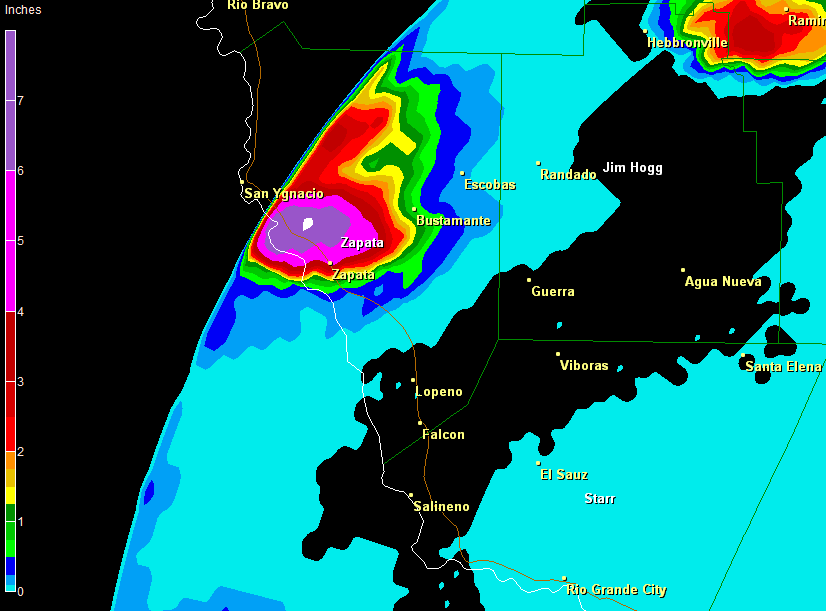
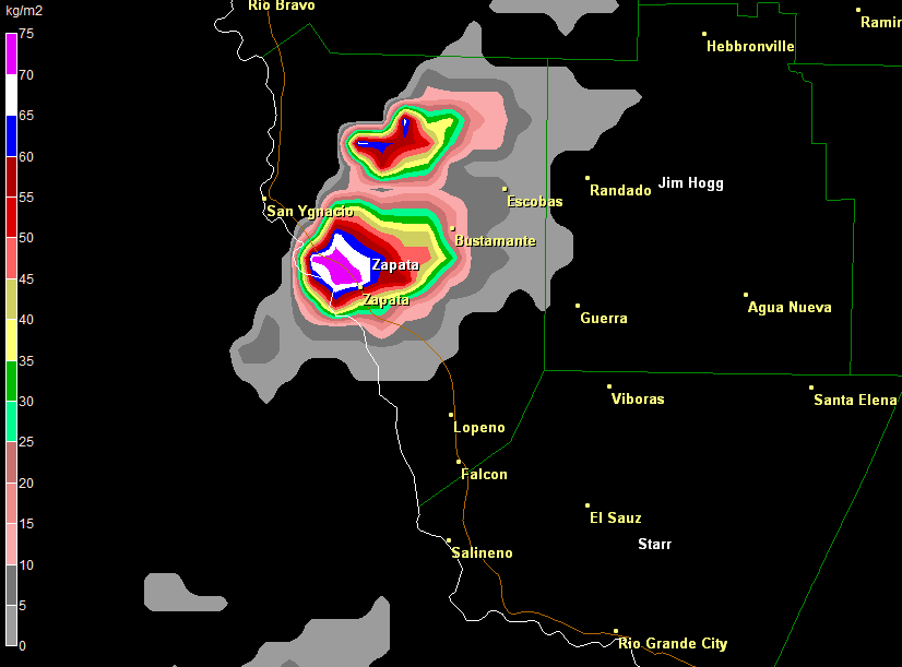
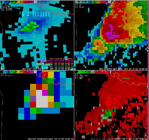
A thunderstorm rapidly developed along the Rio Grande and spread into northwestern and western Zapata County soon after sunset, and soon developed into a mesoscale convective system, likely fed by a tongue of relatively humid air from the southeast. Cold air aloft and a unstable atmospheric profile (at right, below article subtitle), allowed for the system to develop several hail cores through its life cycle. Eventually, hail up to quarter size and perhaps larger fell from the storm, beginning sometime around or shortly after 9 PM and continuing until just before 10 PM when the system finally fell apart. Heavy rains and frequent to locally continuous lightning were also present, eventually producing spotty flash flooding generally north of Zapata and Medina. Radar data (above article title) showed impressive rainfall accumulation (left) and vertically integrated liquid (a measure of potential hail production, right). While the radar estimated value of 9 inches of rain (white dot, upper left) was likely contaminated by ice within the storm, it is quite possible that 6 inches, or two thirds the estimate, fell. 3.75 inches was measured at the Zapata Airport near Medina. Click on this map for specific reports and locations.
|
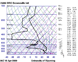
Sounding taken at NWS Brownsville, 7 PM, April 17th 2009. Notice the dry air between 800 and 600mb, along with the sharp lapse rate (diagonal section from lower right to upper left) on the temperature profile in the same layer (right hand line). Image courtesy of University of Wyoming.
Starr and Hidalgo County, April 18
Boundaries from the previous evening’s storms, combined with a final upper level disturbance, continued warm, humid air, and generally light southerly winds sufficient for improved focus allowed scattered thunderstorms to develop once again, beginning during the late morning in the western half of Starr and into Zapata County, slowly spreading across mainly northern Starr County while intensifying. The sounding remained supportive of hail producing storms. Soon after noontime, nickel to quarter size hail developed once again, along with heavy rains, in the slow moving but intense cells. The storms edged into western Hidalgo County during the early afternoon, and continued producing pea to nickel size hail, locally heavy rains, and frequent cloud to ground lightning. Outflows from these storms, perhaps enhanced by southeasterly flow closer to the coast, generated the largest storms of the day, along the Rio Grande from near Hidalgo to Pharr, where pea to half inch hail and considerable lightning was noted.
The cell in southern Hidalgo County gained considerable energy after crossing the river. Radar and satellite data (not shown) indicated heavy precipitation supercell characteristics as the storm moved into Tamaulipas east of Reynosa. Eventually, winds estimated at hurricane force felled numerous trees, and heavy rains caused significant flooding, in the city of Rio Bravo, just 5 miles or so south of the border. An account (in Spanish) can be found here.
|

