| Pair of "Aces" Sets Records Heat spike pushes temperatures past 100°F March 14–15 2008 |
||||||||||||||||||||||||||||||||||||||||||||||||||||||||||||||||||||||||||||||||||||||||||||||||||||||||||||||||||||||||||||||||||||||||||||||||||||||||||||||||||||||
|
As expected, a spike of unseasonably hot and dry air covered much of the Rio Grande Valley and Deep South Texas on March 14th and 15th, courtesy of initially dry west to southwest winds flowing downwind of the higher terrain of northern Mexico and southwest Texas, all courtesy of a developing upper level ridge of high pressure in the central and western Gulf of America. The mixing of dry air from higher levels of the atmosphere to lower levels almost always results in significant warming as the air descends. Meteorologically, we call this process "compression", since direct transfer of heat does not occur; rather, the "heat" is generated by the acceleration of gravity as the air mixes toward the surface. On March 14th and 15th, it was estimated that 15 to 17°C (roughly 30 to 33°F) of warming occurred between 5000 feet and the surface. Given measured and estimated 5000 foot temperatures between 23 to 25°C (roughly 73 to 77°F), resulting in afternoon high temperatures between 100 and 105°F generally from Hidalgo and western Brooks County west to Zapata, Starr, and Jim Hogg Counties. On the 14th, southerly flow in the lower levels helped set up a dry line of much lower humidity from much higher humidity, and heat index, toward the Gulf (Figure 1, right). Temperatures within about 15 miles of the coast were much lower than those farther west; for example, Brownsville only reached 89°F while Harlingen rose to 95°F, and Raymondville even higher, to 101°F. |
On the 15th, weak high pressure built into the region from the northwest, leaving surface winds light westerly to northerly through early afternoon, before turning northeast as the high scooted toward the lower Mississippi Valley. At the same time, measured temperatures at around 5000 feet at 7 AM CDT indicated 25°C. Without the hindrance of Gulf-influenced southeast flow to begin the day, even coastal locations were able to soar to near 100 degrees, before northeast winds took values down a bit by late afternoon. Tables 1 and 2 below show high temperatures and and new, standing, or former records, for March 14th and 15th. As of this writing, virtually every observing location in the lower Rio Grande Valley broke a high temperature record on March 15th! 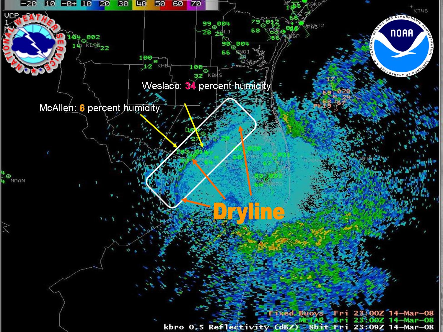 Figure 1. Doppler radar depicted dryline (boxed area) just after 6 PM CDT Friday, 3/14/2008. |
|||||||||||||||||||||||||||||||||||||||||||||||||||||||||||||||||||||||||||||||||||||||||||||||||||||||||||||||||||||||||||||||||||||||||||||||||||||||||||||||||||||
|
|
||||||||||||||||||||||||||||||||||||||||||||||||||||||||||||||||||||||||||||||||||||||||||||||||||||||||||||||||||||||||||||||||||||||||||||||||||||||||||||||||||||||
Table 1. High temperatures (column 2), previous record/year (columns 3 and 4), and new record (yes or no, column 5), 3/14/2008.
|
**Table 2. High temperatures (column 2), previous record/year (columns 3 and 4), and new record (yes or no, column 5), 3/15/2008.
** Preliminary Data as of 530 PM CDT March 15th, 2008
|
|||||||||||||||||||||||||||||||||||||||||||||||||||||||||||||||||||||||||||||||||||||||||||||||||||||||||||||||||||||||||||||||||||||||||||||||||||||||||||||||||||||

