National Weather Service United States Department of Commerce


May 16th 2008: Damaging Winds Roll through Valley
NWS Ridge Radar, base reflectivity, 302 AM CT (click to enlarge) photo of photo of the Harlingen/Valley International Airport control tower with windows knocked out (click to enlarge)
Pre-Dawn Microburst Sweeps Hidalgo to Harlingen
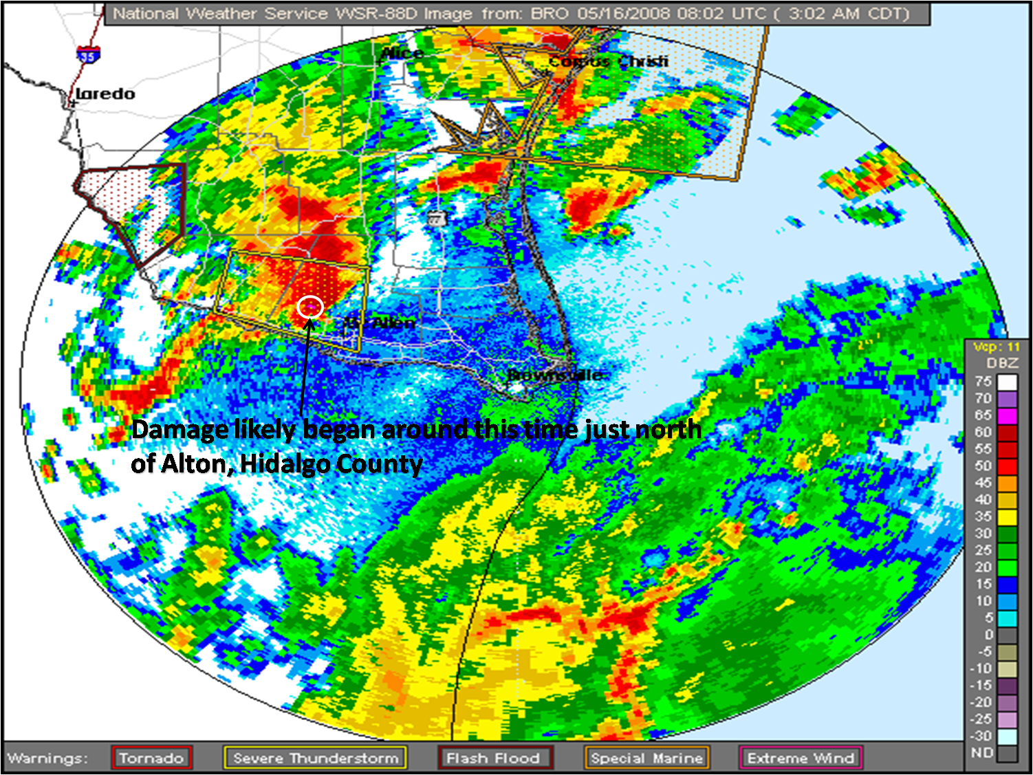
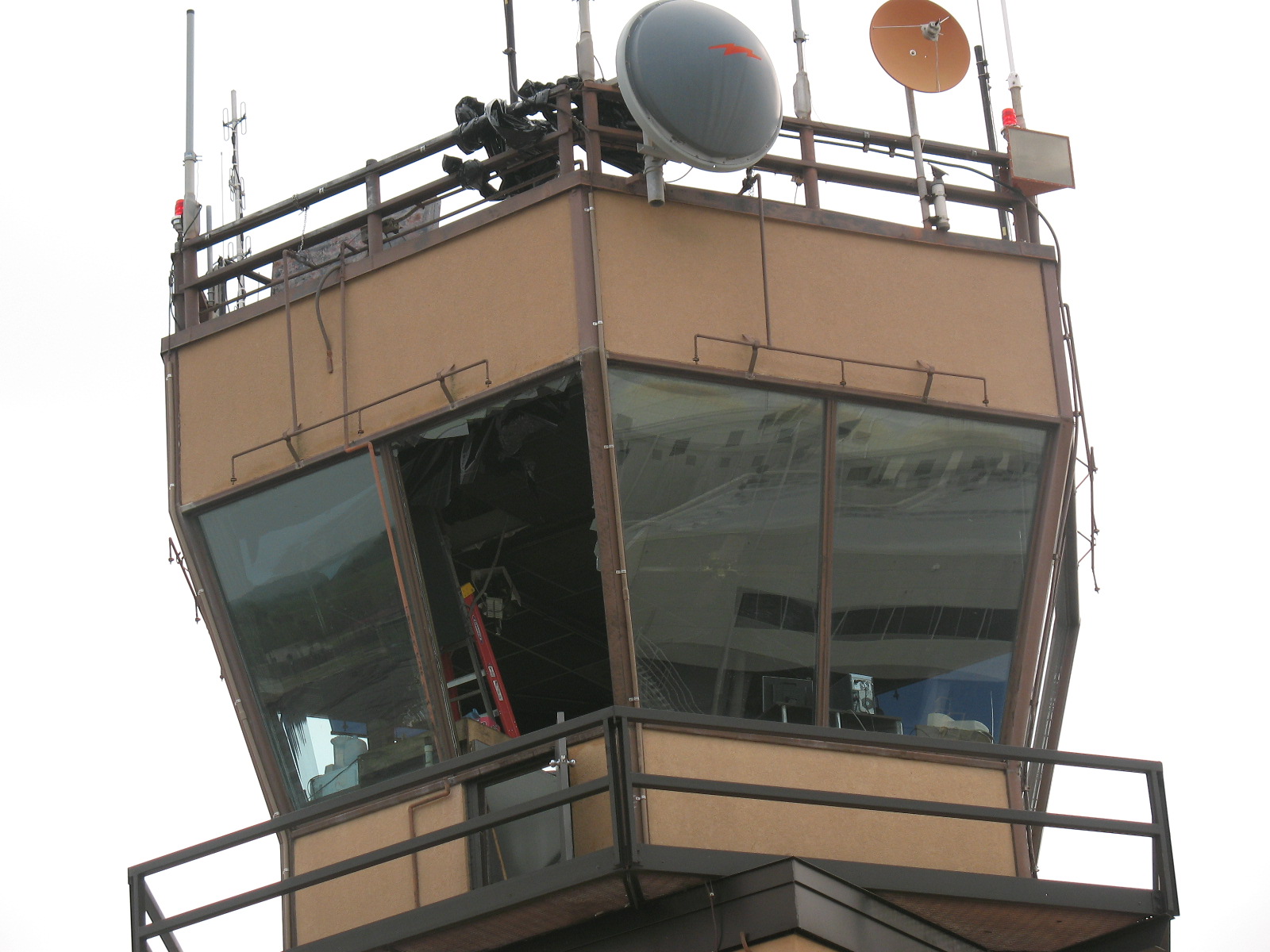
Event:
Severe weather returned to the Valley on a second successive night, this time in the form of a small but potent line of thunderstorms which steadily moved from east to west just north of Federal Highway 83. As the storms moved out of Starr and into Hidalgo County, they rapidly intensified; soon after, estimated wind gusts of 65 to 70 mph caused substantial damage just north of Alton. After a brief lull in eastern Hidalgo County, the storm cranked up again and produced additional damage in western and central Cameron County, where measured wind gusts over 85 mph were reported. Significant damage was noted at the following locations:

Las Cañas Neighborhood/Moorefield Road. The combination of a pulse microburst striking a number of very poorly constructed homes led to the destruction of 20 mainly trailer-type residences, near the intersection of Monte Cristo (Farm to Market Road 1925) and Farm to Market (FM) 681. In a number of cases, the residences were completely demolished; a total of 13 persons required transport to local hospitals. Thankfully, by mid afternoon on the 16th, all were releases. While the majority of injuries were minor, in one instance, a 3 year old girl had to be rescued from a pile of rubble that was once an unanchored trailer home. In addition to the building damage, at least eight wooden telephone poles were pulled down.

The damage track continued to the east southeast, generally along an north of FM 1925, at least to the intersection of FM 1925 and Federal Highway 281, twelve miles away. The vast majority of damage beyond the Las Cañas neighborhood was hundreds of downed limbs from mesquite trees. Based on assessment from an NWS survey team, peak winds were between 65 and 70 mph, with the highest values likely where the telephone poles were pulled down, and again in the mesquite stand about two miles east. A map shows the track and path. Red dots are neighborhoods; green dots are areas of tree damage.

Santa Rosa to Harlingen. Across the County Line in Cameron, known damage began again in Santa Rosa, where a pickup truck was flipped over on a driveway near the intersection of Orphanage and Louisiana; a number of power lines were also down in the area. As the radar indicated velocity further increased, so did notable damage, this time in northeast Harlingen, culminating with an 86 mph wind gust which blew portions of three hangar roofs off. Pieces from one of these roofs, made of heavier asphalt underlines, knocked out at least two large windows in the control tower! In a nearby neighborhood, generally well constructed buildings fared well; however, dozens of large tree limbs were snapped.

The table below shows preliminary statistics from the surveys conducted on May 16th. A host of Photographs were taken by NWS and local emergency management officials. Check back here for updates.

Meteorology in Brief:
Thursday was hazy, hot, and humid. Surface dew point temperatures were in the upper 70s to near 80°F; more than sufficient for thunderstorms to feed off. An analysis of the atmosphere at Brownsville at 7 PM CDT on Thursday showed that precipitable water values were 2.09 inches. That is 158% above normal for this time of year! Thus, an abundance of moisture, combined with instability, and a cold front to our north as the trigger, made for the perfect set up for thunderstorms to occur. Early in the evening on Thursday, thunderstorms formed on the Mexican Plateau near Del Rio. These storms progressed eastward through the evening and into the overnight hours towards Deep South Texas. When the storms arrived in our area they tapped into the highly unstable and moist airmass and intensified greatly as they reached Starr County. The storms trekked from west to east across the Lower Rio Grande Valley, and did not weaken in intensity until they approached the coast.

Hidalgo Survey Recap
Event
Microburst; 65 to 70 mph wind
Time
Estimated began at 3:02 AM CT just north of Alton, continued until at least 3:20 AM CT just east of the intersection of Federal Highway 281 and FM 1925. From Emergency Management Official accounts reconciled with NWS Doppler radar data.
Path
Length: At least 12 miles of sporadic damage. Width: Estimated up to 1 mile wide in the Las Cañas community.
Casualties
13 minor injuries; all released from hospital by afternoon
Preliminary Damage Estimate
Not available due to age of infrastructure damaged.
Cameron Survey Recap
Event
Microburst; 86 mph measured wind gust at Valley International Airport; 70 mph estimated near the ground.
Time
4:00 AM to 4:05 AM CT from Santa Rosa to Harlingen; Valley International Airport observation at 405 AM.
Path
Length: Not totally surveyed. Approximately 1 mile from northeast Harlingen to Valley International Airport. Width: Not determined.
Preliminary Damage Estimate
Estimates not available at time of writing.