National Weather Service United States Department of Commerce


First Hailstorms of Spring 2008
Rake Coastal Counties

Composite reflectivity image, 501 PM CST February 12 2008, Kenedy and Willacy County (click to enlarge)

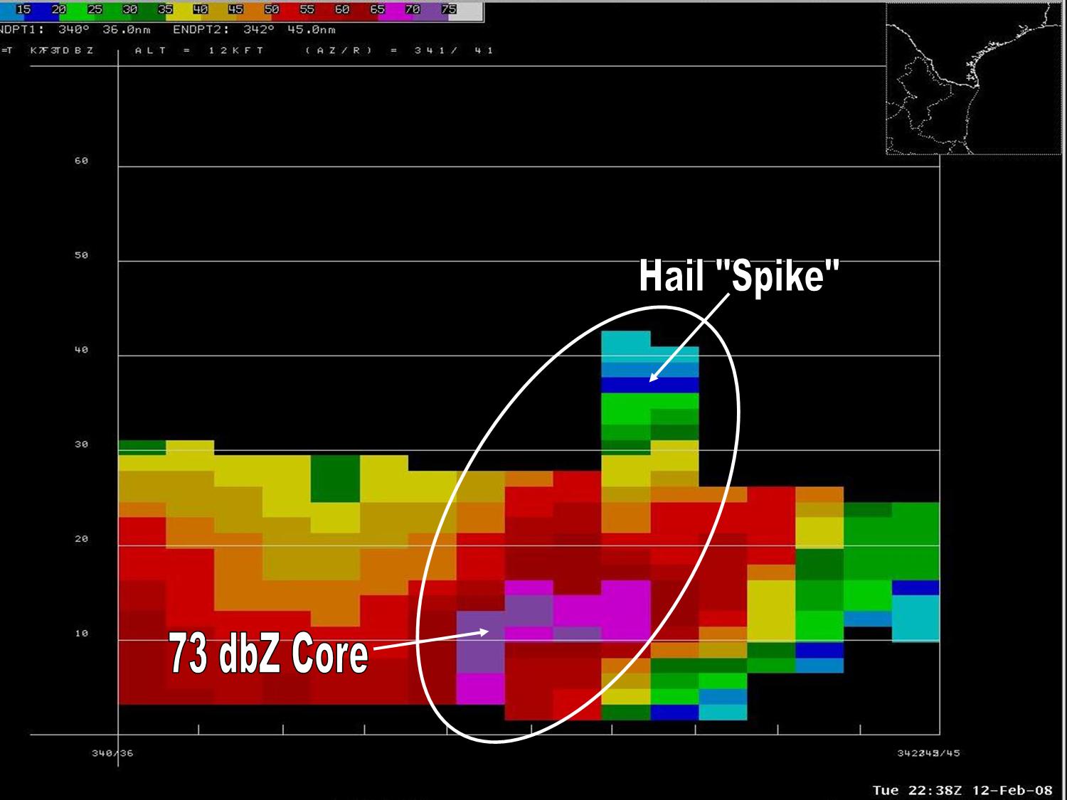
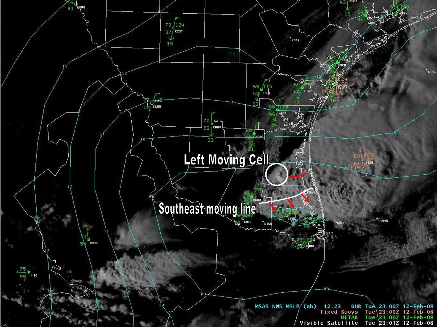
Big thunderstorms developed in a pocket of very unstable air near the coast of Deep South Texas during the mid and late afternoon of February 12th, assisted by lift provided by an advancing cool front moving into the area. Nearly all of the stronger cells were assumed to contain hail; preliminary storm reports (below) indicated several occurrences of hail ranging from pea to as large as golf ball size. Above, circled storm 1, nearing peak intensity over southern Kenedy county just after 5 PM CST, developed as the left-moving entity of a storm split. While no ground truth was received at this point, it is quite possible that large hail was falling across portions of the King Ranch near the Willacy/Kenedy County line east of Rudolph. Circled storm 2, in central Willacy County, would continue to cycle, and eventually produce nickel to quarter size hail in northeast Cameron County near Arroyo City (northeast of Rio Hondo). Circled storm 3, east of Port Mansfield, produced dime to golf ball size hail as it raced through town about 15 minutes earlier.

Below the storm reports, the image at left shows a fairly typical cross section of the strongest cells, in this case northern Willacy County east of Yturria, or about 5 to 7 miles east northeast of Raymondville. This particular cell was part of an earlier line that produced up to half dollar size hail just east of Highway 77 in southern Kenedy County a little more than 10 minutes earlier. At right, note the overshooting "bubble" like tops of the secondary single-cell in southern Kenedy County, and other cycling cells moving southeast through Willacy County, at about the same time as the radar composite at the top of the page.

PRELIMINARY LOCAL STORM REPORT
NATIONAL WEATHER SERVICE BROWNSVILLE TX

..TIME...   ...EVENT...      ...CITY LOCATION...     ...LAT.LON...
..DATE...   ....MAG....      ..COUNTY LOCATION..ST.. ...SOURCE....
            ..REMARKS..

0408 PM     HAIL             13 N RAYMONDVILLE       26.67N 97.78W
02/12/2008  E0.50 INCH       KENEDY             TX   EMERGENCY MNGR

            REPORT OF MARBLE SIZE HAIL APPROXIMATELY 10 MILES NORTH
            OF THE KENEDY WILLACY COUNTY LINE. HAIL COVERING THE
            GROUND LASTING FOR AT LEAST 10 MINUTES.

0430 PM     HAIL             9 NNE RAYMONDVILLE      26.61N 97.74W
02/12/2008  E1.25 INCH       KENEDY             TX   TRAINED SPOTTER

0430 PM     HAIL             9 N RAYMONDVILLE        26.60N 97.79W
02/12/2008  E0.50 INCH       KENEDY             TX   TRAINED SPOTTER

0445 PM     HAIL             9 N RAYMONDVILLE        26.60N 97.79W
02/12/2008  E0.50 INCH       KENEDY             TX   TRAINED SPOTTER

            SECOND STORM IN 15 MINUTES...EACH PRODUCED NEAR DIME SIZE
            HAIL ON THE WILLACY KENEDY COUNTY LINE.
			
0445 PM     HAIL             PORT MANSFIELD          26.55N 97.43W
02/12/2008  E1.75 INCH       WILLACY            TX   CO-OP OBSERVER

            REPORTED BY HUSBAND OF OBSERVER AT RESIDENCE NEAR CENTER
            OF TOWN ON COPANO ROAD.

0450 PM     TSTM WND GST     PORT MANSFIELD          26.55N 97.43W
02/12/2008  M41.00 MPH       WILLACY            TX   CO-OP OBSERVER

            ALSO REPORTED MARBLE SIZE HAIL...0.50 INCH IN
            DIAMETER...AT HARBORMASTER OFFICE LOCATION			
			

0545 PM     HAIL             11 NE RIO HONDO         26.33N 97.44W
02/12/2008  E1.00 INCH       CAMERON            TX   TRAINED SPOTTER

            NICKEL TO QUARTER SIZE HAIL IN ARROYO CITY.


Cross section, northern Willacy County, at 438 PM CST (click to enlarge) Visible satellite combined with surface pressure and surface observations, 501 PM CST (click to enlarge)