National Weather Service United States Department of Commerce


February 16th: The Valley's Blustery Day
6 AM CST February 16th CST upper air sounding, Brownsville, Texas (click to enlarge)
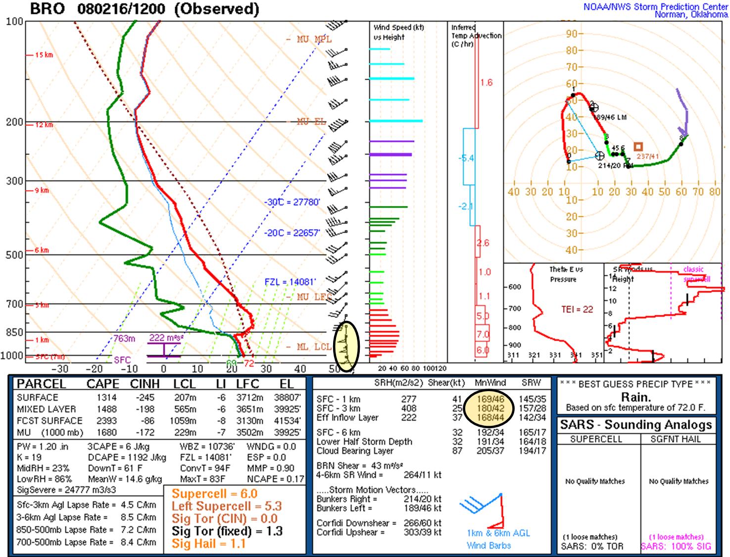
Figure 1. Atmospheric sounding, 6 AM CST February 16th, Brownsville, TX. Note the very strong winds (circled areas). Wind values are in knots; "flags" represent 50 knots.
6 PM CST February 16th 500 mb analysis (click to enlarge)
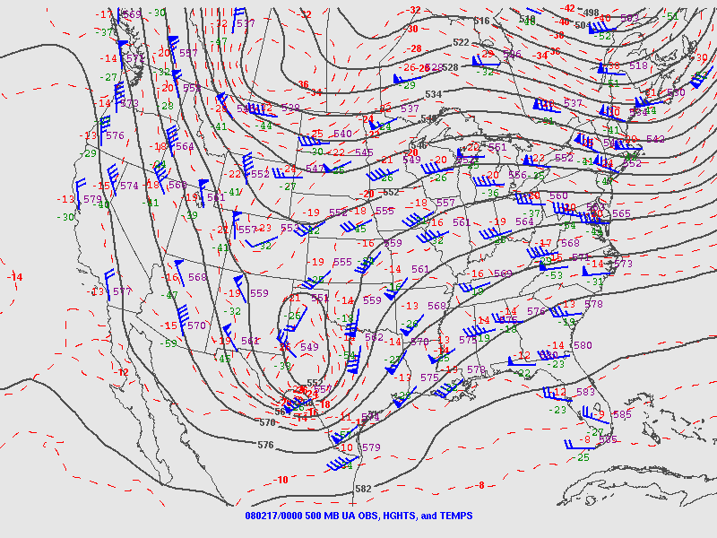
Figure 2. 500 mb analysis, 00z 17 February, 2008. Note the strong cyclone (circular contour) moving across west central Texas.
 

A vigorous upper level disturbance, moving across west Texas during the afternoon on February 16th, enhanced surface low pressure development in northeast Mexico, which in turn tightened the typical Winter and Spring pressure gradient that is created between hot inland areas and the cooler, more stable air over the Gulf waters. As a result, low level winds between the surface and around 5000 feet, averaging nearly 50 mph, translated to the surface by mid to late morning, resulting in a prolonged period of 30 to 40 mph sustained winds with frequent gusts above 45 mph, particularly in Cameron, Willacy, eastern Hidalgo, and Kenedy County. Minor damage was reported to some structures (report, below), especially from Harlingen to Mercedes. A table of peak wind speed, and gusts, is shown below.

Table 1. Selected peak sustained and peak wind gusts, February 16, 2008.
City/Town
County
Sust(mph)
Time
Gust(mph)
Time
Harlingen/VIA
Cameron
44
253 PM
52
253 PM
Brownsville
Cameron
41
226 PM
49
357 PM
Port Isabel
Cameron
36
1230 PM
48
1246 PM
Weslaco
Hidalgo
36
120 PM
44
120 PM
McAllen/Miller
Hidalgo
33
127 PM
43
1103 AM
Edinburg
Hidalgo
26
105 PM
36
125 PM
PRELIMINARY LOCAL STORM REPORT
NATIONAL WEATHER SERVICE BROWNSVILLE TX
1142 PM CST SAT FEB 16 2008

..TIME...   ...EVENT...      ...CITY LOCATION...     ...LAT.LON...
..DATE...   ....MAG....      ..COUNTY LOCATION..ST.. ...SOURCE....
            ..REMARKS..

1200 PM     NON-TSTM WND DMG HARLINGEN               26.20N 97.69W
02/16/2008                   CAMERON            TX   NEWSPAPER

            VALLEY MORNING STAR NEWSPAPER REPORTED ELECTRICAL LINES
            DOWNED BY STRONG WINDS ON WEST MORAN COURT AND ON 23RD
            STREET.

1200 PM     NON-TSTM WND DMG HARLINGEN               26.20N 97.69W
02/16/2008                   CAMERON            TX   NEWSPAPER

            VALLEY MORNING STAR NEWSPAPER REPORTED TREE DOWNED BY
            STRONG WINDS. LOCATION UNKNOWN.

1200 PM     NON-TSTM WND DMG MERCEDES                26.15N 97.92W
02/16/2008                   HIDALGO            TX   BROADCAST MEDIA

            KRGV CHANNEL 5 REPORTED ROOF OF MOBILE HOME BLOWN OFF IN
            MERCEDES BY STRONG WINDS.

0330 PM     NON-TSTM WND DMG LA FERIA                26.16N 97.82W
02/16/2008                   CAMERON            TX   NEWSPAPER

            VALLEY MORNING STAR NEWSPAPER REPORTED TREE DOWNED BY
            STRONG WINDS IN LA FERIA AT INTERSECTION OF PARKER ROAD
            AND EBONY ROAD.