Overview
|
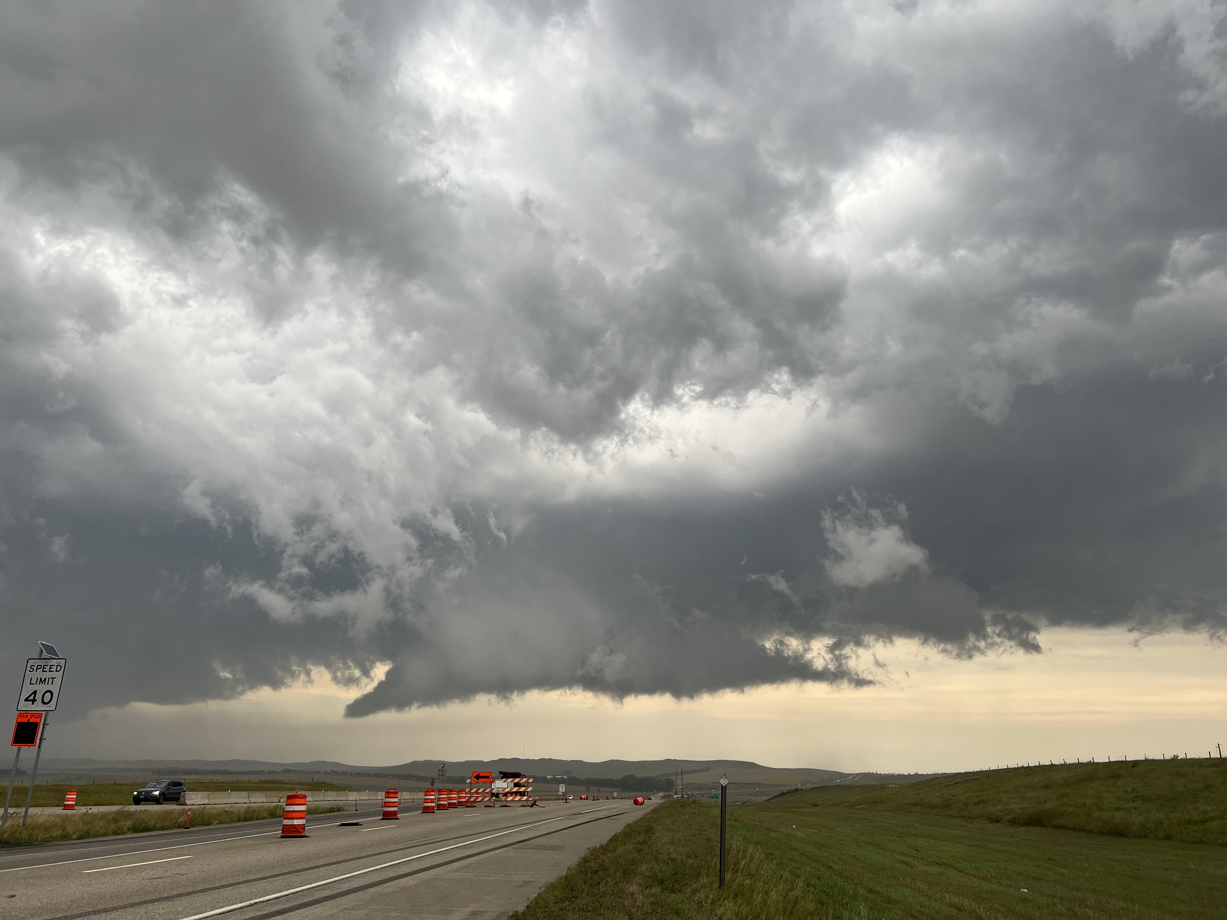
A damaging wind event occurred on Labor Day 2023 across much of southwest and south central North Dakota. A line of thunderstorms moved into southern North Dakota from South Dakota, consolidating into a bowing segment and creating a damaging wind threat across parts of southwest and south central North Dakota. The highest observed wind gust from this event was in Sioux County, with the Tatanka Prairie RAWS station reporting a wind gust of 88 mph at 7:50 PM. Storms then moved into the Bismarck/Mandan area in the 8:00-9:00 PM timeframe, with the Bismarck Airport reporting a wind gust of 64 mph. Many trees were downed across the area, with brief power outages reported in town. The line of storms progressed northeast across the northern James River Valley, eventually reaching the Devil's Lake area and then Grand Forks, where a 77 mph wind gust was reported at the Grand Forks Airport. |
 Tree damage in South Bismarck (photo courtesy Samantha Osmundson) |
Photos & Video
 |
 |
 |
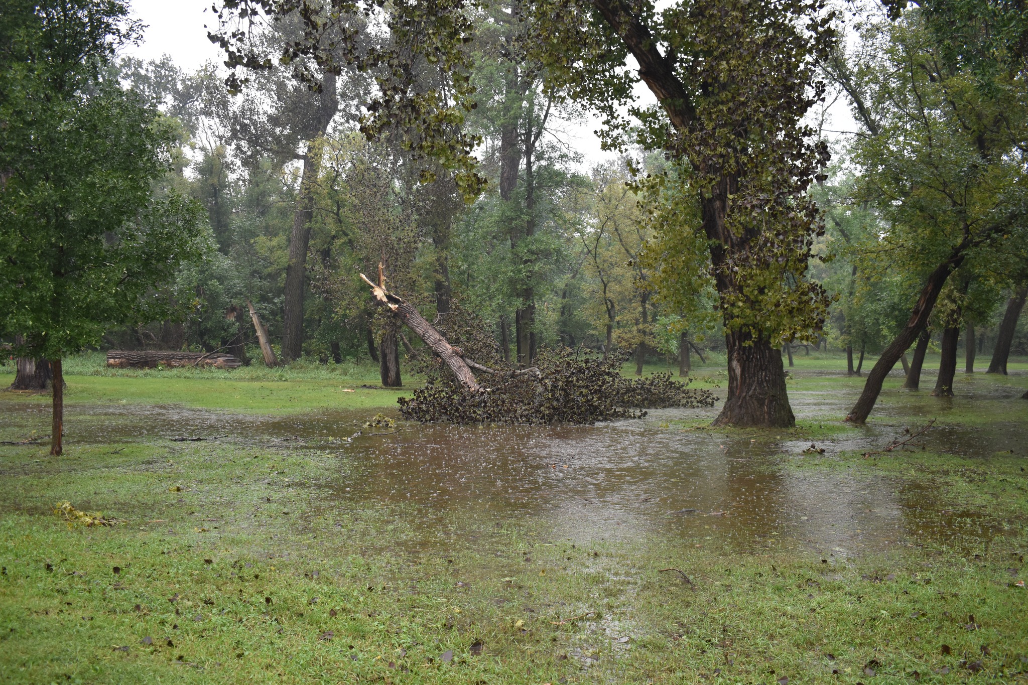 |
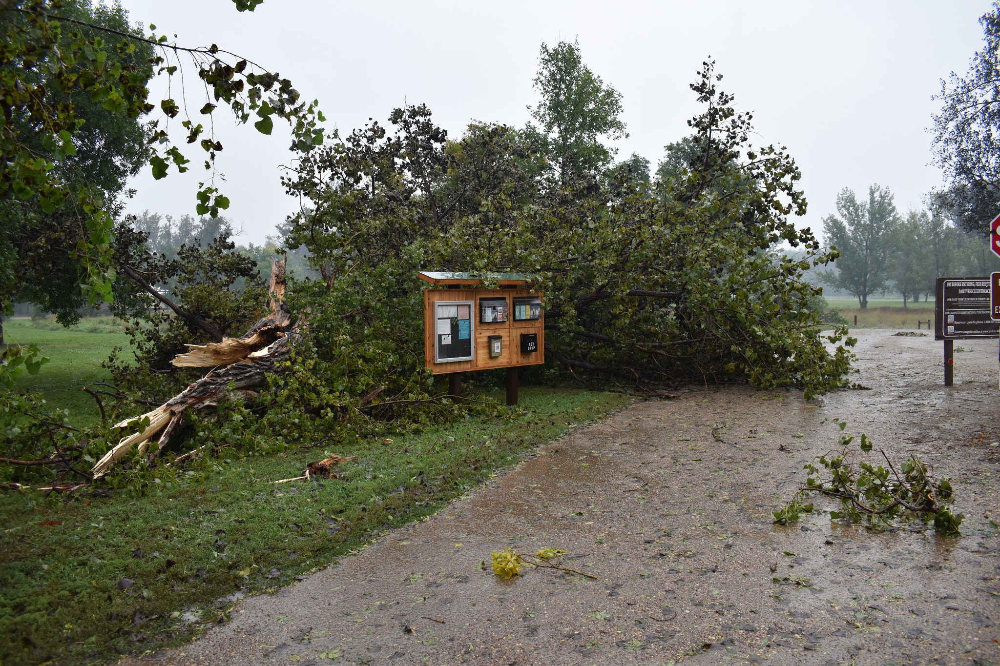
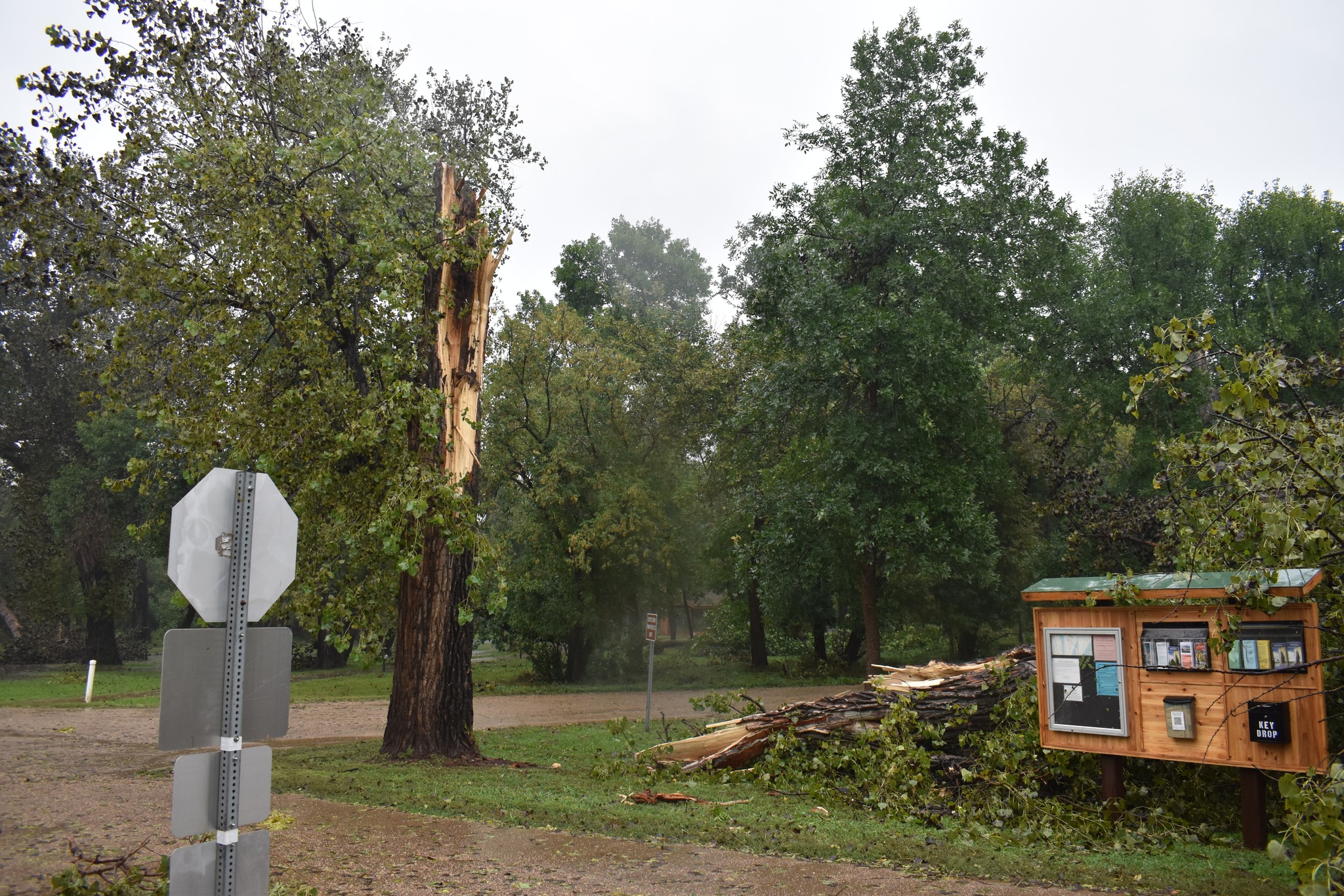
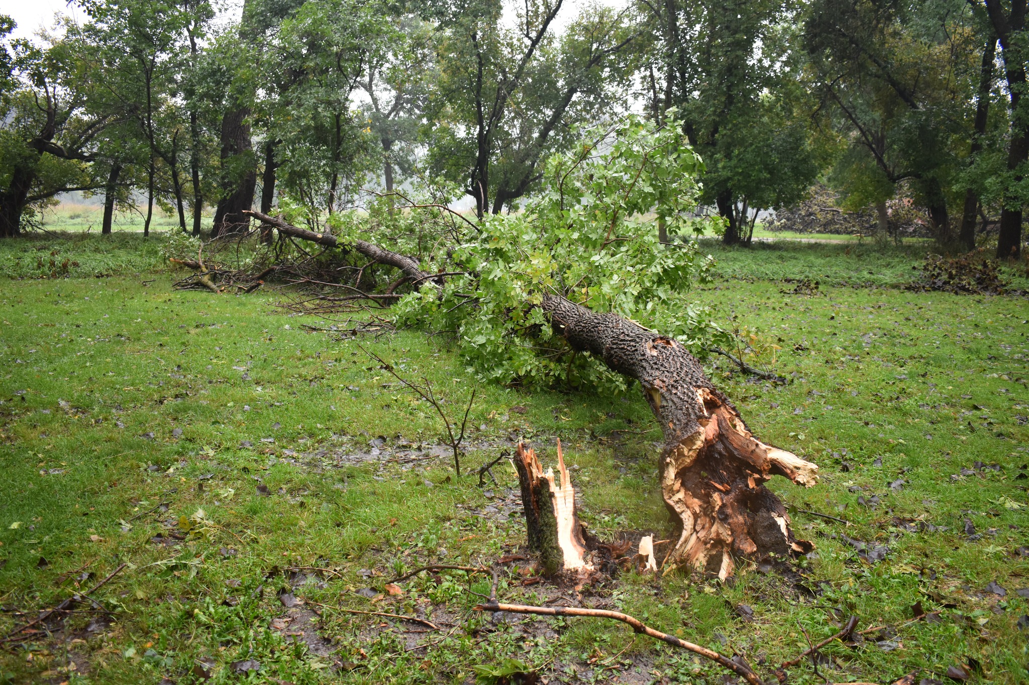
| Cross Ranch State Park (Cross Ranch State Park Facebook) |
Cross Ranch State Park (Cross Ranch State Park Facebook) |
Cross Ranch State Park (Cross Ranch State Park Facebook) |
Cross Ranch State Park (Cross Ranch State Park Facebook) |
 |
 |
 |
 |
| North of New Salem (Shane Ornelas) |
Hebron (Shane Ornelas) |
Bismarck (Elan Azriel) |
South Bismarck (Brittney Sanderson) |
Radar
This radar loop shows the progression of thunderstorms from 5 PM on Monday, September 5th, to 5 AM on September 6th. Thunderstorms moved northeast into southern North Dakota on the evening of the 4th, with a few initial storms developing ahead of the main line. Another round of storms moved in late Monday night and continued into the morning of the 5th, although these storms were not severe.
.gif)
Storm Reports
..TIME... ...EVENT... ...CITY LOCATION... ...LAT.LON...
..DATE... ....MAG.... ..COUNTY LOCATION..ST.. ...SOURCE....
..REMARKS..
0750 PM Tstm Wnd Gst 8 N Selfridge 46.16N 100.90W
09/04/2023 M88 MPH Sioux ND Mesonet
Tatanka Prairie RAWS observation. Timing
based on radar.
0655 PM Tstm Wnd Gst 10 N North Lemmon 46.09N 102.16W
09/04/2023 E70 MPH Adams ND Trained Spotter
0700 PM Tstm Wnd Gst 7 N Glen Ullin 46.92N 101.86W
09/04/2023 E70 MPH Morton ND Public
Also had quarter size hail. Event ongoing at
time of call.
0840 PM Tstm Wnd Gst 3 NE Cross Ranch State 47.24N 100.96W
09/04/2023 E70 MPH McLean ND Trained Spotter
At least quarter size hail. Ongoing at the
time of call.
0640 PM Tstm Wnd Gst 3 NNE Hebron 46.94N 102.02W
09/04/2023 E65 MPH Morton ND Trained Spotter
Pea size hail.
0706 PM Tstm Wnd Gst 15 S Beulah 47.04N 101.80W
09/04/2023 E65 MPH Mercer ND Trained Spotter
2.00 inches of rain and very small soft
hail.
0915 PM Tstm Wnd Gst 2 W Lincoln 46.77N 100.75W
09/04/2023 M64 MPH Burleigh ND ASOS
ASOS station KBIS Bismarck Airport. Winds
gusted between 58 and 64 mph from 915-923 pm
CDT.
1009 PM Tstm Wnd Gst 4 W Barlow 47.58N 99.23W
09/04/2023 M62 MPH Foster ND Public
Private weather station report. Winds lasted
from 1009-1014 pm CDT.
0800 PM Tstm Wnd Gst 1 ESE Lark 46.45N 101.37W
09/04/2023 M61 MPH Grant ND Mesonet
NDAWN Station Carson 9ENE.
0828 PM Tstm Wnd Gst 1 N Lincoln 46.77N 100.70W
09/04/2023 M61 MPH Burleigh ND Public
Private weather station observation near
Lincoln.
0734 PM Tstm Wnd Gst 3 S Heil 46.35N 101.70W
09/04/2023 M60 MPH Grant ND Public
Private weather station observation.
0900 PM Tstm Wnd Gst 5 NW Steele 46.89N 99.99W
09/04/2023 M60 MPH Kidder ND Mesonet
Reported by NDAWN station Steele 5NW.
0940 PM Tstm Wnd Gst 7 NNE Lake Williams 47.22N 99.56W
09/04/2023 E60 MPH Kidder ND Trained Spotter
Strongest winds lasted around 10 minutes.
0807 PM Tstm Wnd Gst Flasher 46.45N 101.23W
09/04/2023 M59 MPH Morton ND Public
Davis site observation, private weather
site.
0956 PM Tstm Wnd Gst 2 W Sykeston 47.46N 99.45W
09/04/2023 M59 MPH Wells ND Public
Davis weather observation report.
0840 PM Hail 3 NE Cross Ranch State 47.25N 100.96W
09/04/2023 E1.25 inch McLean ND Trained Spotter
Ongoing at time of call.
0700 PM Hail 7 N Glen Ullin 46.92N 101.86W
09/04/2023 M1.00 inch Morton ND Public
Also estimated 60-70 mph winds with the
hail.
0717 PM Hail 8 NNE Glen Ullin 46.93N 101.77W
09/04/2023 M1.00 inch Morton ND Trained Spotter
Wind Gusts Estimated at 60 mph.
0800 PM Tstm Wnd Dmg Carson 46.42N 101.56W
09/04/2023 Grant ND Public
Power line downed around 8pm CDT, rain
moving sideways estimated to be a minimum of
50 mph. Relayed through social media.
0838 PM Tstm Wnd Dmg Cross Ranch State Park 47.21N 101.00W
09/04/2023 Oliver ND Park/Forest Srvc
Cross Ranch State Park Facebook Post reports
with photos of several big trees down, a lot
of branches down, and standing water in
park. Time estimated based on radar.
0915 PM Tstm Wnd Dmg Bismarck 46.81N 100.78W
09/04/2023 Burleigh ND Public
Mature tree and several tree branches were
knocked down from strong thunderstorm winds
(64 mph measured at Bismarck Airport),
reported on social media.
&&
$$
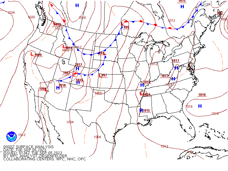
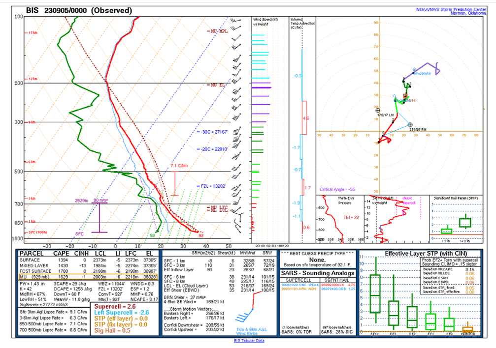
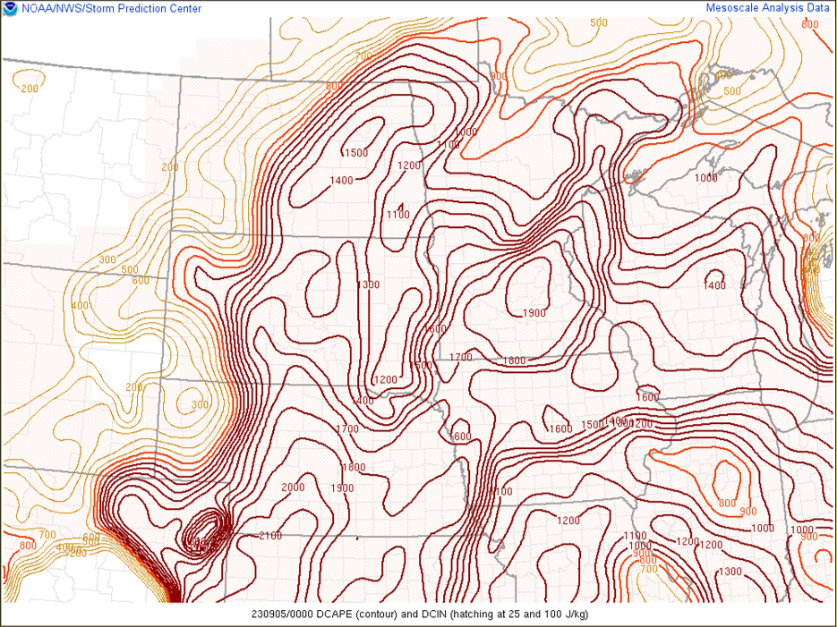
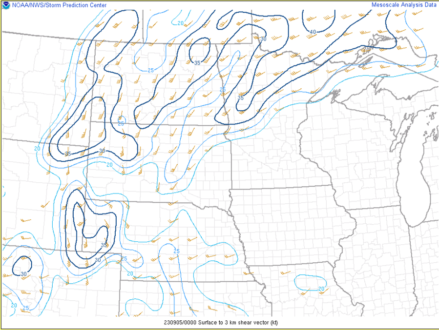
Environment
A strong upper level wave and sharp cold front provided the lift for thunderstorm initiation. Strong shear, especially in the 0 to 3 KM layer, combined with high DCAPE had all the makings for a strong wind event. Instability was sufficient for stronger storms, although lacked a little bit in the hail growth zone. Thus hail was mainly limited to initial isolated supercells.
 |
 |
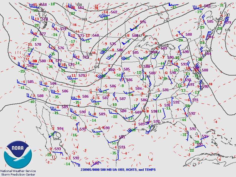 |
| Figure 1: Analyzed surface fronts from the Weather Prediction Center | Figure 2: 00z September 5th Balloon Launch at Bismarck | Figure 3: 500 MB Analysis showing the sharp upper level wave |
 |
 |
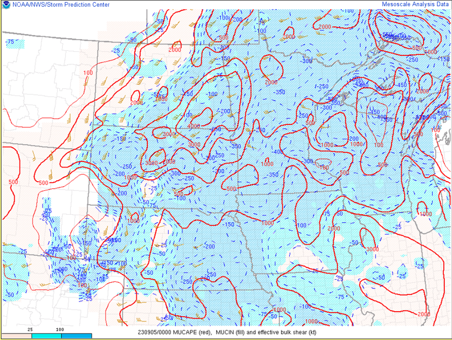 |
| Figure 4: Strong DCAPE was found over much of central and eastern ND | Figure 5: 0 to 3 KM Shear was also quite sufficient for strong winds | Figure 6: MUCAPE was elevated, yet capped until the evening hours. This capping showed up during the 19z Special Balloon Launch at Bismarck (not shown) |
 |
Media use of NWS Web News Stories is encouraged! Please acknowledge the NWS as the source of any news information accessed from this site. |
|

