
Photo courtesy of Phil Whitlock
This year marks the 23rd anniversary of the November 1, 2000 tornadoes that touched down in the greater Bismarck/Mandan area. These are the latest tornadoes in the calendar year on record for the state of North Dakota. In total, 5 tornadoes touched down the afternoon of Wednesday, November 1st, with 2 injuries and 42 homes that sustained mild to moderate damage. This was a very busy weather day across the state, with winter weather headlines in western North Dakota, where snow was beginning to fall at the same time the tornadoes occurred in the central part of the state.
The day's weather was caused by a strong surface low moving through the Dakotas. These surface analysis maps from the Weather Prediction Center show the northeastward progression of the low, marked by the "L", beginning at 12Z on Wednesday (6 AM CST) and ending at 06Z (12 AM Thursday morning). The lines surrounding the "L" on these maps are called isobars, which connect points of equal pressure. Extending from the center of the low are frontal boundaries, such as a cold front (line with triangles), warm front (line with half circles), and stationary front (line with alternating triangles and half circles). Find more information on how to read surface weather maps here.
.gif)
Before this day, the latest tornado on record for the state was on October 11th, 1979, in Sargent County. On November 1st, 2000, the new record latest, there were 5 tornadoes that touched down in the greater Bismarck/Mandan area in south central North Dakota. The map below, from the Midwest Regional Climate Center, shows the path length and location of each tornado. F-0 tornadoes (light damage) are indicated in blue, and F-1 tornadoes (moderate damage) are in green. These were rated using the original Fujita scale, as the Enhanced-Fujita (EF) scale was not introduced until 2007.
.png)
Map of tornado tracks from the Midwest Regional Climate Center
.bmp)
Picture from Todd Hamilton, one of WFO Bismarck's Lead Forecasters


Photos from the Bismarck Tribune. Left - debris accumulating along the curb on Edmonton Drive in North Bismarck. Right - tornado seen from north Mandan shortly after 3 pm.
The first tornado warning of the day was issued at 2:33 PM CST, for the tornado 7 miles north of Bismarck that was reported by SKYWARN spotters. Warnings were then issued at 2:50 PM, 3:05 PM, 3:29 PM, and 3:43 PM, and a Tornado Watch was issued by the Storm Prediction Center for southeastern North Dakota.
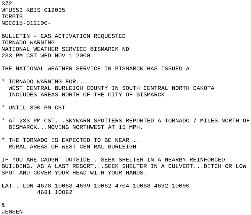
Text of the first tornado warning issued on November 1
The radar loop from Bismarck's radar KBIS, from 1:52 PM to 5:57 PM, shows the broad counterclockwise rotation caused by the low pressure centered overhead. This led to the unusual east to west movement of the storms and tornadoes.
.gif)
At the same time the tornadoes were occurring, snow was beginning in western North Dakota on the cold side of the strong surface low. Snow continued through the night and ended on November 2nd. This storm system brought heavy snow accumulations and wind gusts up to 50 mph in western North Dakota. As a result, many roads were closed, and a tour bus accident in Bowman County seriously injured a number of passengers. Power outages were widespread across the northwest part of the state.
.png)
For more data from this day, including the specific location and timing of each tornado, check out our full storm data report.

