Binghamton, NY
Weather Forecast Office
Flood control dam doing its job!
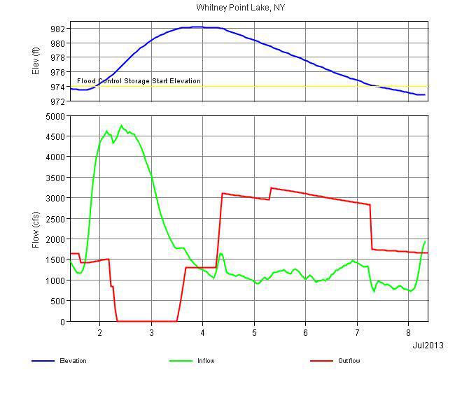
This is a graph of Whitney Point reservoir being controlled by the Army Corps of Engineers. The dam is at the end of the Otselic River just before it empties into the Tioughnioga River. Heavy rain fell into the Otselic River and across Chenango and Madison Counties at the beginning of the month. On the left side of the graph the dam started holding water (red line at bottom) raising the lake level (blue line at top) on July 2nd and 3rd. This prevented downstream locations on the Chenango River from Chenango Forks to Binghamton from flooding. It also lowered river levels on the Susquehanna River from Binghamton downstream. On July 3rd the dam starting releasing water. On the 7th the lake elevation was back to normal after holding back 8 feet of water. The lake can hold back over 30 feet of water which it did in 2011 and 2006.

Current Hazards
Briefing
Drought
Fire Weather
Graphical Hazardous Weather Outlook
Hurricanes
Local Outlook
River Flooding
Space Weather
Thunderstorms
Winter
Current Conditions
Air Quality
Local Storm Reports
Observation (list)
Observations (Map)
More Surface Observations
Rainfall
Satellite
More Satellite
Upper Air
Radar
Local Enhanced Radar
Local Standard Radar (low bandwidth)
Regional/National Standard Radar (low bandwidth)
More Radar
Forecasts
Activity Planner
Aviation
Fire Weather
Forecaster's Discussion
HeatRisk
Hourly View
Map View
Model Data
NWS GIS Viewer
Space Weather
Text Products
Rivers and Lakes
River Observation/Forecasts (Map)
River Forecast Centers
County Flash Flood Guidance
Current Streamflow
Ensemble River Guidance
Flood Inundation Maps
US Dept of Commerce
National Oceanic and Atmospheric Administration
National Weather Service
Binghamton, NY
32 Dawes Drive
Johnson City, NY 13790
(607) 729-1597
Comments? Questions? Please Contact Us.

