Binghamton, NY
Weather Forecast Office
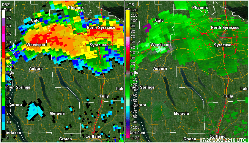
A severe thunderstorm moved southeast across central New York during the early evening on July 28, 2002. The storm produced scattered tree damage along its entire path from western Onondaga county southeast across Cortland county. Along most of that patch, the damage was indicative of straight-line winds, with gusts of 50 to 70 mph from the northwest. However, a brief tornado touchdown occurred with the storm in the small town of Mottville, where the most severe damage occurred. The tornado touchdown occurred at approximately 6:40 pm in the center of town, where a trailer house was completely destroyed and several large trees were sheared off 10 to 20 feet off of the ground. The trees fell in a swirling pattern, indicating that the cause of the damage was most likely a small tornado. Based on the damage, the tornado was estimated as an F1, with top winds of 73 to 112 mph. The tornado’s path length was 100 yards, and its path width was approximately 50 yards.
Radar loop is from the National Weather Service radar in Binghamton, NY. Elevation 0.5 degrees with base reflective to the left and storm relative motion to the right. Loop is from 6:12 PM to 7:12 PM EDT.
                        
                            Current Hazards
                        
                                                    Briefing
                                                    Drought
                                                    Fire Weather
                                                    Graphical Hazardous Weather Outlook
                                                    Hurricanes
                                                    Local Outlook
                                                    River Flooding
                                                    Space Weather
                                                    Thunderstorms
                                                    Winter
                                            
                        
                            Current Conditions
                        
                                                    Air Quality
                                                    Local Storm Reports
                                                    Observation (list)
                                                    Observations (Map)
                                                    More Surface Observations
                                                    Rainfall
                                                    Satellite
                                                    More Satellite 
                                                    Upper Air
                                            
                        
                            Radar
                        
                                                    Local Enhanced Radar
                                                    Local Standard Radar (low bandwidth)
                                                    Regional/National Standard Radar (low bandwidth)
                                                    More Radar
                                            
                        
                            Forecasts
                        
                                                    Activity Planner 
                                                    Aviation 
                                                    Fire Weather 
                                                    Forecaster's Discussion
                                                    HeatRisk
                                                    Hourly View
                                                    Map View
                                                    Model Data
                                                    NWS GIS Viewer
                                                    Space Weather 
                                                    Text Products
                                            
                        
                            Rivers and Lakes
                        
                                                    River Observation/Forecasts (Map)
                                                    River Forecast Centers
                                                    County Flash Flood Guidance
                                                    Current Streamflow
                                                    Ensemble River Guidance
                                                    Flood Inundation Maps
                                            
                US Dept of Commerce
                National Oceanic and Atmospheric Administration
                National Weather Service
                Binghamton, NY
                32 Dawes Drive
                                Johnson City, NY 13790
                
(607) 729-1597
                
Comments? Questions? Please Contact Us.


