Binghamton, NY
Weather Forecast Office
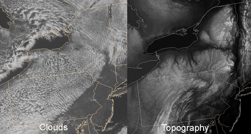
The image below shows a field of springtime stratocumulus clouds that developed across New York and Pennsylvania with a northwest wind flow.

Why were there no clouds over New Jersey or southeastern portions of New York and Pennsylvania? Take a look at the topography (below) of the region and compare it to the field of stratocumulus.

As the northwest wind crossed the Appalachian Mountains and began descending toward the east coast, the air underwent a basic meteorological process called adiabatic compression.
As a parcel of air rises, there is less and less air above it so the air parcel expands due to the decreasing surrounding air pressure. Likewise, as an air parcel descends there is more and more air above it so the parcel becomes compressed. The Ideal Gas Law (PV=nRT) tells us that if the pressure of an air parcel changes but all other aspects of the parcel remain the same, there must be a corresponding change in temperature to keep the equation balanced. Thus, rising air expands and cools while descending air compresses and warms. Since the amount of moisture in the parcel does not change but the temperature increases, the humidity of the parcel decreases. As the humidity decreases, the clouds evaporate.
Current Hazards
Briefing
Drought
Fire Weather
Graphical Hazardous Weather Outlook
Hurricanes
Local Outlook
River Flooding
Space Weather
Thunderstorms
Winter
Current Conditions
Air Quality
Local Storm Reports
Observation (list)
Observations (Map)
More Surface Observations
Rainfall
Satellite
More Satellite
Upper Air
Radar
Local Enhanced Radar
Local Standard Radar (low bandwidth)
Regional/National Standard Radar (low bandwidth)
More Radar
Forecasts
Activity Planner
Aviation
Fire Weather
Forecaster's Discussion
HeatRisk
Hourly View
Map View
Model Data
NWS GIS Viewer
Space Weather
Text Products
Rivers and Lakes
River Observation/Forecasts (Map)
River Forecast Centers
County Flash Flood Guidance
Current Streamflow
Ensemble River Guidance
Flood Inundation Maps
US Dept of Commerce
National Oceanic and Atmospheric Administration
National Weather Service
Binghamton, NY
32 Dawes Drive
Johnson City, NY 13790
(607) 729-1597
Comments? Questions? Please Contact Us.

