A hourly weather graph forecast can be generated by going to the Hourly Graph website.
Guide to decoding the forecast below.
767
FNUS81 KBGM 261932
FWMBGM
FCST,301011,250427,13,1,56,44,,,NNW,17,,62,39,82,42,0,0,N
FCST,301011,250428,13,0,68,30,,,SSW,02,,70,38,76,29,0,0,N
FCST,301011,250429,13,2,79,47,,,SW,11,,80,49,64,27,0,0,N
FCST,301011,250430,13,1,61,39,,,NW,08,,82,46,83,38,0,0,N
FCST,301011,250501,13,2,66,46,,,S,05,,68,41,82,33,0,0,N
FCST,301011,250502,13,2,69,58,,,SW,10,,71,56,90,45,0,0,N
FCST,301011,250503,13,1,56,47,,,WNW,10,,71,44,89,45,0,0,N
FCST,300171,250427,13,2,45,73,,,NW,18,,60,36,96,70,0,0,N
FCST,300171,250428,13,1,64,35,,,WNW,04,,66,37,82,34,0,0,N
FCST,300171,250429,13,2,73,51,,,SSW,11,,75,47,65,31,0,0,N
FCST,300171,250430,13,1,54,46,,,NW,10,,77,44,89,45,6,0,N
FCST,300171,250501,13,2,63,43,,,S,05,,65,36,82,41,0,0,N
FCST,300171,250502,13,2,67,62,,,SW,10,,68,52,90,40,0,6,N
FCST,300171,250503,13,2,53,54,,,WNW,11,,69,43,93,53,0,0,N
FCST,361802,250427,13,2,51,55,,,NW,19,,71,41,79,52,3,0,N
FCST,361802,250428,13,0,71,26,,,NW,02,,72,43,68,26,0,0,N
FCST,361802,250429,13,1,76,40,,,SSW,06,,77,48,68,24,0,0,N
FCST,361802,250430,13,1,69,32,,,NW,06,,79,55,78,30,0,0,N
FCST,361802,250501,13,2,68,36,,,S,03,,72,44,68,28,0,0,N
FCST,361802,250502,13,2,72,55,,,SW,05,,73,52,93,35,0,0,N
FCST,361802,250503,13,1,64,41,,,W,06,,74,49,89,41,0,0,N
FCST,360791,250427,13,2,46,64,,,NW,21,,65,39,86,63,0,0,N
FCST,360791,250428,13,0,65,31,,,WNW,03,,66,38,76,30,0,0,N
FCST,360791,250429,13,1,72,48,,,SSW,11,,73,48,63,29,0,0,N
FCST,360791,250430,13,1,62,41,,,NW,11,,74,50,86,41,0,0,N
FCST,360791,250501,13,2,63,46,,,S,05,,65,43,70,35,0,0,N
FCST,360791,250502,13,2,68,62,,,SW,11,,69,52,93,44,0,0,N
FCST,360791,250503,13,1,56,49,,,WNW,12,,69,46,93,47,0,0,N
FCST,360792,250427,13,2,52,54,,,NW,18,,70,39,86,50,0,0,N
FCST,360792,250428,13,0,68,31,,,NW,02,,71,39,76,29,0,0,N
FCST,360792,250429,13,1,75,46,,,SSW,09,,78,48,61,27,0,0,N
FCST,360792,250430,13,1,66,38,,,NW,08,,80,51,86,36,0,0,N
FCST,360792,250501,13,2,67,45,,,S,04,,71,44,70,31,0,0,N
FCST,360792,250502,13,2,71,58,,,SW,08,,74,53,90,42,0,0,N
FCST,360792,250503,13,1,60,46,,,WNW,09,,75,47,89,43,0,0,N
FCST,360151,250427,13,2,54,52,,,NNW,16,,67,41,79,50,0,0,N
FCST,360151,250428,13,0,68,32,,,W,02,,69,40,76,31,0,0,N
FCST,360151,250429,13,2,76,48,,,SSW,09,,77,49,63,29,0,0,N
FCST,360151,250430,13,1,64,39,,,NW,06,,79,50,84,38,0,0,N
FCST,360151,250501,13,2,67,47,,,S,05,,68,43,82,34,0,0,N
FCST,360151,250502,13,2,72,58,,,SW,08,,72,56,90,45,0,0,N
FCST,360151,250503,13,1,59,48,,,WNW,08,,72,46,93,47,0,0,N
FCST,361031,250427,13,2,51,57,,,NW,19,,69,40,79,54,3,0,N
FCST,361031,250428,13,0,69,27,,,NW,02,,70,42,70,26,0,0,N
FCST,361031,250429,13,1,75,43,,,SSW,09,,75,46,68,25,0,0,N
FCST,361031,250430,13,1,67,34,,,NW,09,,77,53,83,33,0,0,N
FCST,361031,250501,13,2,67,39,,,S,04,,70,44,70,29,0,0,N
FCST,361031,250502,13,2,71,58,,,SW,08,,71,51,96,37,0,0,N
FCST,361031,250503,13,1,62,44,,,W,09,,72,47,93,43,0,0,N
FCST,300971,250427,13,1,51,54,,,NNW,23,,57,38,89,52,0,0,N
FCST,300971,250428,13,0,64,36,,,SSW,05,,65,38,82,35,0,0,N
FCST,300971,250429,13,2,76,54,,,SSW,17,,77,50,62,33,0,0,N
FCST,300971,250430,13,1,55,50,,,NNW,12,,78,45,86,48,0,0,N
FCST,300971,250501,13,2,63,50,,,S,09,,63,39,82,45,0,0,N
FCST,300971,250502,13,2,66,64,,,SW,14,,67,56,90,48,9,0,N
FCST,300971,250503,13,2,52,58,,,WNW,14,,67,43,89,56,0,0,N
301
FNUS51 KBGM 261931
FWFBGM
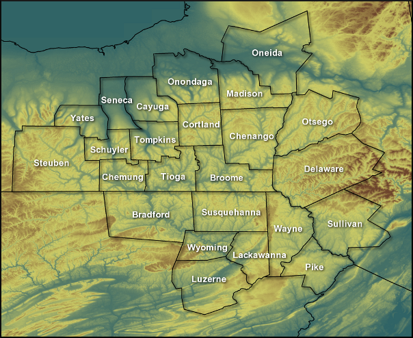
Fire Weather Planning Forecast for Central NY/Northeast PA
National Weather Service Binghamton NY
330 PM EDT Sat Apr 26 2025
.SYNOPSIS... A strong cold front pushes through this afternoon
and evening, with scattered rain and even a few wet snow showers
over the higher elevations tonight into Sunday morning. High
pressure then builds over the area Sunday into Monday with dry
conditions and seasonable temperatures.
NYZ210-270800-
Leatherstocking-
330 PM EDT Sat Apr 26 2025
Tonight Sun Sun Night Mon
Cloud Cover Mcldy Mcldy Clear Mclear
Precip Type Showers Showers None None
Chance Precip (%) 50 50 0 0
Chance of Thunder (%) 0 0 0 0
Temp (24h trend) 36 (-20) 55 (-10) 35 68
RH % (24h trend) 100 (0) 40 (+13) 92 26
Wind 20ft/early(mph) W 13-17 G25 NW 15-19 G27 NW 7-11 G22 Lgt/Var
Wind 20ft/late(mph) W 13-17 G27 NW 16-20 G27 Lgt/Var Lgt/Var
Precip Amount 0.06 0.03 0.00 0.00
Precip Duration 2 1
Precip Begin 6 PM Continuing
Precip End Continuing 2 PM
Mixing Hgt(ft-agl/msl) 4660 4780
Transport Wnd (mph) NW 33 W 8
Vent Rate (kt-ft) 157260 54490
DSI 4 2 1 2
Sunshine Hours 5 13
ADI early 46 Gen Good 68 Good 82 Good 42 Gen Good
ADI late 29 Fair 111 Very Good6 Very Poor 47 Gen Good
Max LVORI early 3 4 3 4
Max LVORI late 4 3 5 1
Remarks: ADI is Atmospheric Dispersion Index by Lavdas.
LVORI is Low Visibility Occurrence Risk Index.
.FORECAST FOR DAYS 3 THROUGH 7...
.TUESDAY...Partly cloudy. A 50 percent chance of showers and
thunderstorms. Lows in the upper 40s. Highs in the mid 70s. South
winds 5 to 10 mph.
.WEDNESDAY...Mostly cloudy. Showers likely and a chance of
thunderstorms. Cooler. Lows in the mid 40s. Highs in the upper
50s. Chance of precipitation 70 percent. West winds around
10 mph.
.THURSDAY...Partly cloudy. A 40 percent chance of rain showers.
Lows in the upper 30s. Highs in the mid 60s. North winds around
5 mph.
.FRIDAY...Mostly cloudy with showers likely. Lows around 50.
Highs in the upper 60s. Chance of showers 70 percent. Southeast
winds 5 to 10 mph.
.SATURDAY...Mostly cloudy. A chance of showers and a slight
chance of thunderstorms. Cooler. Lows in the mid 40s. Highs in
the mid 50s. Chance of precipitation 50 percent. Southwest winds
around 10 mph.
$$
PAZ038-039-043-270800-
Bradford-Susquehanna-Wyoming-
Including the cities of Sayre, Towanda, Hallstead, Montrose,
and Tunkhannock
330 PM EDT Sat Apr 26 2025
Tonight Sun Sun Night Mon
Cloud Cover Mcldy Mcldy Clear Mclear
Precip Type Showers Showers None None
Chance Precip (%) 20 20 0 0
Chance of Thunder (%) 0 0 0 0
Temp (24h trend) 37 (-21) 58 (-10) 36 70
RH % (24h trend) 92 (-8) 37 (-1) 85 27
Wind 20ft/early(mph) NW 14-18 G27 NW 15-19 G32 NW 7-11 G25 Lgt/Var
Wind 20ft/late(mph) NW 13-17 G31 NW 16-20 G31 NW 3-7 Lgt/Var
Precip Amount 0.01 0.00 0.00 0.00
Precip Duration 1 1
Precip Begin 1 AM Continuing
Precip End Continuing 11 AM
Mixing Hgt(ft-agl/msl) 5140 5310
Transport Wnd (mph) NW 36 SW 7
Vent Rate (kt-ft) 173300 39440
DSI 4 3 2 2
Sunshine Hours 6 13
ADI early 55 Gen Good 80 Good 99 Good 33 Fair
ADI late 30 Fair 138 Very Good6 Very Poor 41 Gen Good
Max LVORI early 3 4 3 4
Max LVORI late 3 2 4 1
Remarks: ADI is Atmospheric Dispersion Index by Lavdas.
LVORI is Low Visibility Occurrence Risk Index.
.FORECAST FOR DAYS 3 THROUGH 7...
.TUESDAY...Partly cloudy. A 40 percent chance of showers and
thunderstorms. Lows in the upper 40s. Highs in the upper 70s.
South winds 5 to 10 mph.
.WEDNESDAY...Mostly cloudy. A 50 percent chance of showers and
thunderstorms. Cooler. Lows in the upper 40s. Highs in the mid
60s. Northwest winds around 10 mph.
.THURSDAY...Mostly cloudy. A 40 percent chance of showers. Lows
in the lower 40s. Highs in the upper 60s. Northeast winds around
5 mph.
.FRIDAY...Mostly cloudy with showers likely. Lows in the lower
50s. Highs around 70. Chance of showers 70 percent. Southeast
winds 5 to 10 mph.
.SATURDAY...Mostly cloudy. A chance of showers and a slight
chance of thunderstorms. Cooler. Lows in the mid 40s. Highs in
the upper 50s. Chance of precipitation 40 percent. Southwest
winds around 10 mph.
$$
PAZ044-047-270800-
Lackawanna-Luzerne-
Including the cities of Scranton, Hazleton, and Wilkes-Barre
330 PM EDT Sat Apr 26 2025
Tonight Sun Sun Night Mon
Cloud Cover Pcldy Pcldy Clear Mclear
Precip Type None None None None
Chance Precip (%) 0 0 0 0
Chance of Thunder (%) 0 0 0 0
Temp (24h trend) 39 (-19) 59 (-10) 38 70
RH % (24h trend) 85 (-15) 38 (+7) 82 26
Wind 20ft/early(mph) NW 13-17 G28 NW 15-19 G33 NW 8-12 G26 Lgt/Var
Wind 20ft/late(mph) NW 13-17 G33 NW 16-20 G33 NW 3-7 G17 Lgt/Var
Precip Amount 0.00 0.00 0.00 0.00
Precip Duration
Precip Begin
Precip End
Mixing Hgt(ft-agl/msl) 5250 5280
Transport Wnd (mph) N 36 W 7
Vent Rate (kt-ft) 173630 33530
DSI 4 3 2 2
Sunshine Hours 7 13
ADI early 48 Gen Good 84 Good 99 Good 33 Fair
ADI late 31 Fair 136 Very Good6 Very Poor 40 Fair
Max LVORI early 3 3 2 3
Max LVORI late 3 2 3 1
Remarks: ADI is Atmospheric Dispersion Index by Lavdas.
LVORI is Low Visibility Occurrence Risk Index.
.FORECAST FOR DAYS 3 THROUGH 7...
.TUESDAY...Partly cloudy. A slight chance of showers. Lows in the
upper 40s. Highs in the upper 70s. South winds around 5 mph.
.WEDNESDAY...Mostly cloudy. A chance of showers and a slight
chance of thunderstorms. Cooler. Lows in the lower 50s. Highs in
the upper 60s. Chance of precipitation 50 percent. Northwest
winds around 10 mph.
.THURSDAY...Mostly cloudy. A 30 percent chance of showers. Lows
in the mid 40s. Highs in the upper 60s. North winds around 5 mph.
.FRIDAY...Mostly cloudy. Showers likely. Lows in the lower 50s.
Highs in the lower 70s. Chance of showers 70 percent. South winds
5 to 10 mph.
.SATURDAY...Mostly cloudy. A chance of showers and a slight
chance of thunderstorms. Cooler. Lows in the upper 40s. Highs in
the lower 60s. Chance of precipitation 40 percent. Southwest
winds around 5 mph.
$$
PAZ040-048-072-270800-
Northern Wayne-Pike-Southern Wayne-
Including the cities of Damascus, Equinunk, Milford,
and Honesdale
330 PM EDT Sat Apr 26 2025
Tonight Sun Sun Night Mon
Cloud Cover Pcldy Mcldy Mclear Mclear
Precip Type Showers Showers None None
Chance Precip (%) 20 20 0 0
Chance of Thunder (%) 0 0 0 0
Temp (24h trend) 38 (-18) 54 (-15) 38 70
RH % (24h trend) 92 (-8) 45 (+12) 85 24
Wind 20ft/early(mph) NW 12-16 G27 NW 14-18 G31 NW 8-12 G26 Lgt/Var
Wind 20ft/late(mph) NW 13-17 G33 NW 16-20 G31 NW 3-7 G17 Lgt/Var
Precip Amount 0.03 0.00 0.00 0.00
Precip Duration 1 1
Precip Begin 6 PM Continuing
Precip End Continuing 1 PM
Mixing Hgt(ft-agl/msl) 4390 5710
Transport Wnd (mph) NW 38 W 7
Vent Rate (kt-ft) 174240 46140
DSI 4 2 1 2
Sunshine Hours 6 13
ADI early 42 Gen Good 80 Good 100 Good 55 Gen Good
ADI late 36 Fair 132 Very Good10 Poor 56 Gen Good
Max LVORI early 3 3 3 3
Max LVORI late 3 3 4 1
Remarks: ADI is Atmospheric Dispersion Index by Lavdas.
LVORI is Low Visibility Occurrence Risk Index.
.FORECAST FOR DAYS 3 THROUGH 7...
.TUESDAY...Partly cloudy. A slight chance of showers. Lows in the
mid 40s. Highs in the mid 70s. South winds up to 10 mph.
.WEDNESDAY...Mostly cloudy. A 50 percent chance of showers.
Cooler. Lows in the lower 50s. Highs in the mid 60s. Northwest
winds around 10 mph.
.THURSDAY...Mostly cloudy. A slight chance of showers. Lows in
the lower 40s. Highs in the upper 60s. North winds around 5 mph.
.FRIDAY...Mostly cloudy with showers likely. Lows around 50.
Highs around 70. Chance of showers 70 percent. Southeast winds
around 5 mph.
.SATURDAY...Mostly cloudy. A chance of showers and a slight
chance of thunderstorms. Lows in the mid 40s. Highs in the lower
60s. Chance of precipitation 40 percent. Southwest winds around
5 mph.
$$