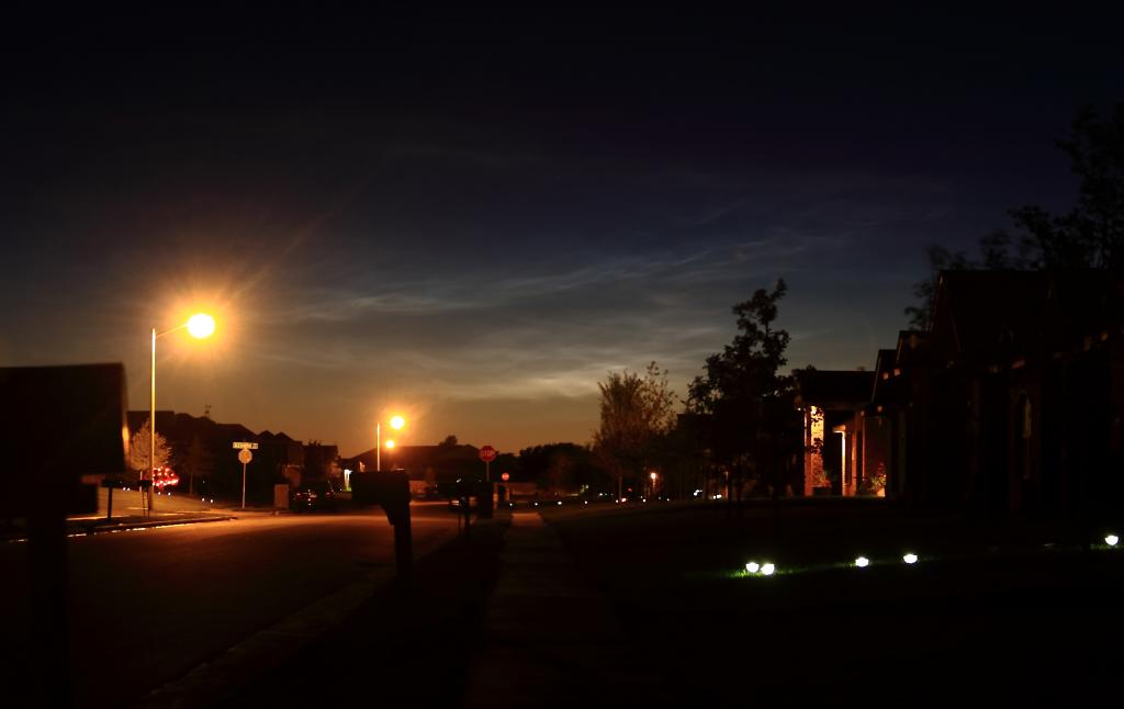
| Photographs taken from Amarillo between 8:15 and 8:20 PM CDT Sunday evening, September 29, provide a rare glimpse of the highest clouds to grace Earth's atmosphere.
 |
| Noctilucent clouds visible in Amarillo (Courtesy Todd Lindley) |
At a height of 50 miles above the earth, noctilucent or “night-shining” mesospheric clouds, occur at much higher altitudes than typical clouds which generally reach heights of only 10 miles or less. The atmosphere at the altitude of mesospheric clouds is very cold, with temperatures colder than -180 degrees Fahrenheit. The irony is that noctilucent clouds occur most frequently in summer, when global circulations in the middle parts of the atmosphere transport water vapor and methane toward Earth’s polar regions.
So why and how did rare summertime polar clouds form in the autumn skies above Amarillo? The answer may be found in the launch of the SpaceX Falcon 9 rocket carrying the Canadian Space Agency’s Cassiope satellite which took off from Vandenberg Air Force Base, California at 11 AM CDT Sunday morning. NWS meteorologists and researchers from Hampton University in the United Kingdom who analyzed the photographs theorize that by some nine hours later, exhaust emissions from the spaceship had spread eastward and introduced enough water vapor into the upper edge of the atmosphere to illuminate the fine ice particles of noctilucent clouds above the west Texas sunset. Although there were not a sufficient number of photographs from varying locations submitted to triangulate the location of the clouds, a rough analysis using the expected height of noctilucent clouds and their elevation above the Amarillo horizon, it is estimated that the clouds may have been physically located over Arizona.
 |
| Approximate location of noctilucent clouds |
First observed in 1885 following the eruption of Krakatoa, noctilucent clouds are thought to be increasing in frequency, brightness, and becoming visible at lower latitudes as a result of human activity and climate change. In recent years noctilucent cloud sightings have migrated south of their typical 50 degree to 70 degree latitude range to as far south as Golden, Colorado (39.8 degrees N in 1999) and the Carla Alto Observatory in Spain (37.2 degrees N in 2012). Similar to Sunday’s sighting at Amarillo (35.1 degrees N), unusual mesospheric clouds were seen near Tucson, Arizona (32 degrees N) in 1963 following a series of rocket launches from the Pacific Missile Range in California. Although much about noctilucent clouds remains a mystery, they are believed to form when water vapor and methane introduced into the upper atmosphere, by either natural events such as volcanic eruptions or manmade sources such as spacecraft, develop tiny ice nuclei within the extremely cold and dry environment at the edge of space. Invisible during daylight, these mesospheric clouds emit a tenuous white or blue coloration as they bask in the final rays of sunlight high above the darkened Earth well after sunset. The clouds only became visible in the skies above Amarillo some 40 to 45 minutes past sunset. In 2007, the Aeronomy of Ice in the Mesosphere satellite was launched specifically to investigate noctilucent clouds and their potential link to changes in atmospheric composition and climate.
 |
 |
| Comparison of mesospheric noctilucent clouds at 8:20 PM CDT on September 29 (left) and typical tropospheric cirrus clouds at 8:20 PM CDT on October 3 (right). The mesospheric clouds continue to reflect light well after dark, while tropospheric clouds darken when overcome by the Earth's shadow. (Courtesy Todd Lindley) |
|
