A slow moving front will bring rounds of strong to severe thunderstorms and heavy rainfall to the central Plains eastward to the east-central U.S.. The first widespread significant heat wave of summer for the Intermountain West and Plains is expected to develop today and expand through next week. Dangerous heat will continue to impact portions of the Southwest and Southeast. Read More >
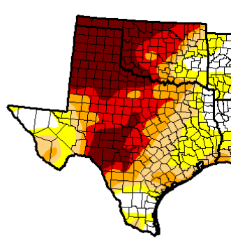
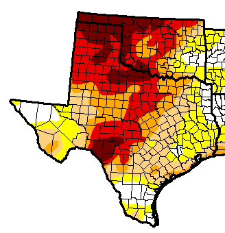
| May 21-26, 2014 Drought Relief | ||||||||||||
|
||||||||||||
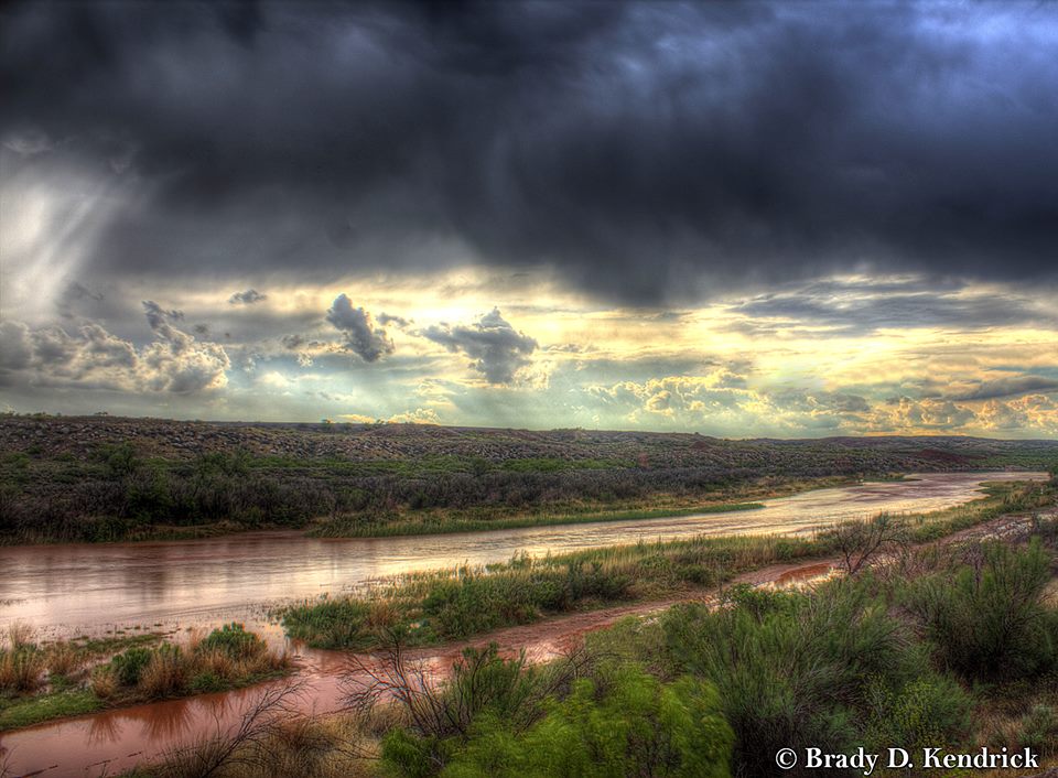
| A very slow moving upper-level storm system over the Desert Southwest allowed abundant moisture to be drawn into the southern High Plains. With sufficient lift and moisture in place, multiple rounds of showers and thunderstorms impacted the Texas and Oklahoma Panhandles for six conescutive days. Before the onset of the event, much of the region was experiencing its driest 43 months on record, but rainfall amounts up to six inches provided some drought relief, especially across the southern half of the Texas Panhandle. Even better news was that very little severe weather accompanied the storm system, which is fairly uncommon for late May. | ||||||||||||
|
||||||||||||
|
||||||||||||
| Thanks to the rainfall, 2014 precipitation totals after the rain event actually increased by as much as 400% compared to the precipitation totals before the start of the event. Before this rain event, most places were actually drier than 2011. However, 2014 precipitation totals are now not even close to the historically dry year of 2011 through May 27. | ||||||||||||
|
||||||||||||
| Not only did heavy rain occur across the Panhandles, but much of West Texas saw beneficial rains, particularly for many locations west of Interstate 35. This also reduced the areal extent of exceptional, or D4, drought conditions across Texas and Oklahoma. In fact, the May 27 Drought Monitor indicated 10.76% of Texas was in D4 drought conditions compared to just over 25% of the state on May 20. The areal extent of D2-D4 and D3-D4 drought conditions was reduced, too. | ||||||||||||
|
||||||||||||
| Heavy rains also caused some localized flooding issues, but overall, the flooding was minor. The rain also produced some slight rises in rivers and lakes, including Lake Meredith that saw levels increase by almost two feet. The Canadian River north of Amarillo rose to just above five feet, allowing kayakers to paddle down the river! | ||||||||||||
|