
A very active spring pattern with tropical concerns across the Pacific. Heavy rainfall will continue to impact Hawaii this weekend. Meanwhile we continue to monitor a developing typhoon that may affect Guam into early next week. For the Lower 48, heavy snow for mountains of California this weekend, increase threat for severe thunderstorms next week for the Plains and record warmth spreads east. Read More >
May 15, 2009 Tornado and Severe Thunderstorm Information |
||
|
On May 15, 2009, severe thunderstorms developed across the eastern Texas Panhandle producing large hail, intense winds, and 5 tornadoes. The National Weather Service in Amarillo conducted damage surveys and determined that 3 of these tornadoes were EF0 on the Enhanced Fujita scale, while 1 tornado was an EF1, and the strongest tornado was rated as an EF2. |
 |
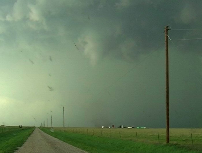
The image above is courtesy of Markus Pfister and Mark Vornhusen who are two stormchasers and professional meteorologists from Switzerland. They were on a vacation chasing storms in the United States. |
| The storms formed along a cold front that was moving south from Kansas. As the front passed from the Oklahoma Panhandle into the Texas Panhandle, storms rapidly developed in an area of deep moisture. Although limited wind shear (strong winds turning with height) was present on May 15, one storm was able to begin rotating and eventually spawned the tornadoes. This storm first became severe over central Roberts county, but as it moved south, the storm began to rotate and the first tornado developed in southern Roberts county about 13 miles west of Miami. The second tornado formed a short while later also in Roberts county about 14 miles west southwest of Miami. The third tornado developed after the storm crossed into Gray county. This tornado lasted for about 4 minutes and occurred roughly 5 miles northeast of Pampa. The fourth tornado was the strongest of the day. This tornado touched down 4 miles east northeast of Pampa and caused the most damage. Finally, the last tornado developed 2 miles northwest of Lefors in Gray county and was rated as an EF1. A more complete summary of the tornado ratings along with path length and tornado width can be found by reading our Public Information Statement: HERE | |||||||||
|
Pampa Area: The following images will show damage from the Pampa Area. |
|||||||||
|
Along with the tornadoes that developed, strong downburst winds combined with large hail up to the size of Grapefruits causing significant damage to homes. The following images show damge from downburst (or straight line) winds. Even though these winds were non-tornadic, notice how much damage they can cause. |
 |
|
|||||||
 |
 |
 |
 |
||||||
 |
 |
||||||||
| As mentioned above, this storm also produce an EF2 tornado just to the northeast of Pampa. The following images show the funnel cloud and eventual tornado that developed from this storm. These next three images are again courtesy of Markus Pfister and Mark Vornhusen. The first image shows the funnel cloud, while the next two show the tornado. Notice the dust being kicked up at the ground which indicates the tornado. |  |
 |
 |
||||||
Finally, these last few images show some of the damage that occurred due to the tornado east of Pampa. |
 |
 |
 |
||||||
|
 |
 |
 |
||||||
 |
|||||||||
Lefors damage and photo from I-40 near Alanreed. |
 |
 |
 |
||||||
 |
 |
||||||||
Storm Photos courtesy of Markus Pfister and Mark Vornhusen. |
 |
 |
 |
||||||
 |
A lightning strike triggered a small grass fire near Pampa. | ||||||||


