Severe thunderstorms which can bring large hail, damaging winds, and isolated tornadoes will be possible over parts of the central U.S. through this weekend. Thunderstorms with heavy to excessive rainfall moving from Texas into the mid-Mississippi Valley through this weekend may produce areas of flooding. Read More >
| Wildfires in the Texas and Oklahoma Panhandles |
|
On Thursday March 30, a fire broke out in northeast Amarillo. Although there was no word of injuries, preliminary estimates of 400 to 700 acres were burned with more than 10 homes destroyed. Strong westerly winds of 30 to 40 mph behind a dryline combined with very low relative humidity values to produce very dangerous fire conditions. The peak wind gust at Rick Husband International Airport was recorded at 54 mph. |
|
|
|
|
 |
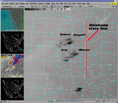
This is a screen capture of an enhanced satellite image of the wildfires burning in the Texas Panhandle. The fires are the bright purple images mainly in Gray and Roberts counties. A rough estimate of the lenght of the fires appears to be between 30 and 40 miles. This image was taken at about 6:00 pm CST on Sunday the 12th of March. |
|
You may also notice a few other smaller fires burning across the area. There is one small fire |
|
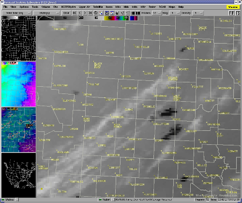 |
This is another enhanced satellite image of the fires burning in the Texas Panhandle. The fires are shown here as dark black spots. This image was take at 6:30 pm CST. The white streaks are clouds moving into the panhandles from the south west and are not associated with the fires. Between 5:30 pm and 6:30 pm the surface winds shifted from the southwest to a more westerly direction (blowing from the west to the east). This caused the fires to start moving more to the east and now endager the town of Miami. |
|
|
This image shows the progression of the fires as of 9:30 pm CST. Notice the fires are still creeping to the east due to the strong west winds. Officials noted that the fire in Roberts county had burned 211,000 acres by 9:30 pm. There have been no reports to the size of the fire in Gray and Wheeler counties, but you may notice that the fire sizes are very similar based on these satellite images. You may notice another slightly smaller fire in southern Childress county. No information is known for this fire at this time. |