|
The picture above was taken around 8:30 pm on Monday August 21st, 2006 in the neighborhood of Meteorologist in Charge, Jose Garcia. He noted the water level to be about 2 feet deep along these streets. This forced a number of residents to walk home as their cars were stalled in the rising waters. At least one home in this area had 2 inches of water inside the house with numerous homes around the west side of Amarillo reporting water flowing into basements. Businesses were also affected by the flash flood. The Target department store on Soncy and West Gate Mall Parkway had water rush into the store when one of the back doors broke due to the weight of the water. Baptist Saint Anthonys Hospital on Coulter St. north of Interstate 40 had a muddy water mixture drift into their basement. The Fire and Police Departments were kept busy rescuing stalled motorists through the evening. And of course the most tragic result of the flash flood was the 17 year old male drowning victim.
So what is the difference between a flash flood and a regular flood, and what caused this event in Amarillo? Well, a flash flood is almost self defining. Flash floods aremainly caused by torrential rains, a dam break, or an ice jam break. The key factor is that the water is flowing quickly and occurs within 6 hours of the event causing the flooding. Whereas a regular flood is most commonly associated with large rivers or ocean waters breaching their banks. This may also be caused by torrential rains or a dam failure, but the key would be the slower movement of the water and longer time between the rain and the flood.
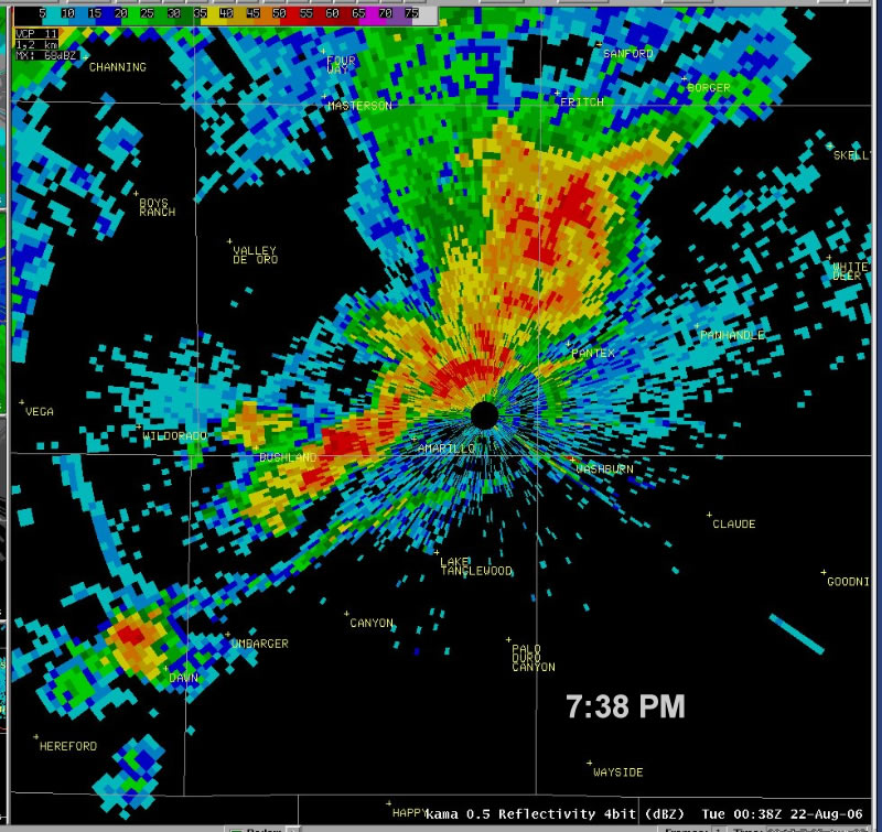
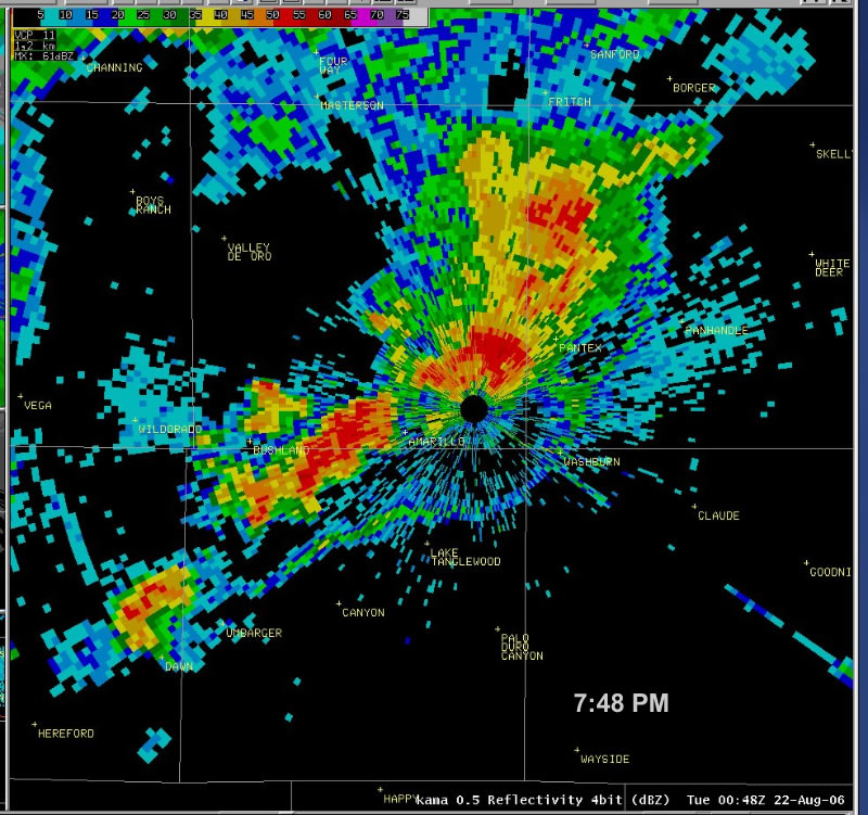
Torrential rains from a thunderstorm was the factor that lead to the flash flooding in Amarillo on the 21st. The thunderstorms over Amarillo were generated by two outflow boundaries that merged just north of the city. Below is a series of radar images taken between 7:24 PM and 7:48 PM on Monday shortly after the thunderstorms developed along the merging outflow boundaries. (An outflow boundary is a line of strong winds that are pushed out away from a thunderstorm. They can be a good area for future storm development but often indicate that the source storm will soon dissipate.)
 |
 |
 |
 |
 |
The radar images show about a half hour worth of data, but notice how little the storms, or the boundary, moved. The black hole in the center of the image is the location of the WSR 88D Radar at the National Weather Service. Very little rain fell on the east and southeast parts of town. Here at the Weather Service office, only 0.09" of rain fell compared to the 4"+ that accumulated on the west side of town! The storms lingered around Amarillo until nearly 9:00 PM that evening. (Click on an image to enlarge) |
The following images are courtesy of the Amarillo Globe News.
 |
Amarillo Fire Department rescues a man from a Toyota 4Runner on Monday night along Amarillo Boulevard near Mississippi Street. |
|
|
A man places a "Slow" caution sign out to warn southbound drivers on Carolina St. that the road was impassable Monday, August 21, 2006. |
|
|
A vehicle with "Road Runner Driving School" sticker drives eastbound down Wolfin Ave. Monday, August 21, 2006. |
 |
Motorists and residents push a car after flood waters caused several cars to stall on Wolflin Avenue east of Coulter Street on Monday, Aug. 21, 2006. |
 |
The debris on a walkway Tuesday at Medical Park Lake shows the level of the water running over from Monday's rain. |
 |
David Sougstad with Harrington Regional Medical Center looks over the damage to the eastbound lanes of Southwest Ninth Avenue on Tuesday after the street collapsed from the runoff from Monday's rains. That section of road is just west of Wallace Boulevard near Medical Center Park. |
Most of the flash flooding and associated damage took place between the
Interstate 40/Interstate 27 interchange and Soncy road, and from 45th Avenue
to just north of the Interstate 40.
|

