Overview
After cooler than normal days due to cloud cover across the Panhandles after a cold front pushed through, sunshine broke through the clouds and allowed for adequate instability and shear to develop and support severe thunderstorms. Thunderstorms developed in a moisture-rich upslope regime in southeast Colorado and then moved south into the western OK panhandle. A thunderstorm moved south out of Colorado and dropped a couple brief tornadoes in Cimarron County, OK and then proceeded to move south across the Texas Panhandle. As the storm moved south, it dropped baseball size hail in Dalhart, TX. Other thunderstorms developed nearby and started to congeal with the original storm into a line of storms before moving through Amarillo and the southern TX Panhandle. Before leaving the TX Panhandle, some of the stronger segments dropped 70 to 80 mph winds.Tornadoes:
|
Tornado - LOCATION
Tornado 6 miles North of Keyes 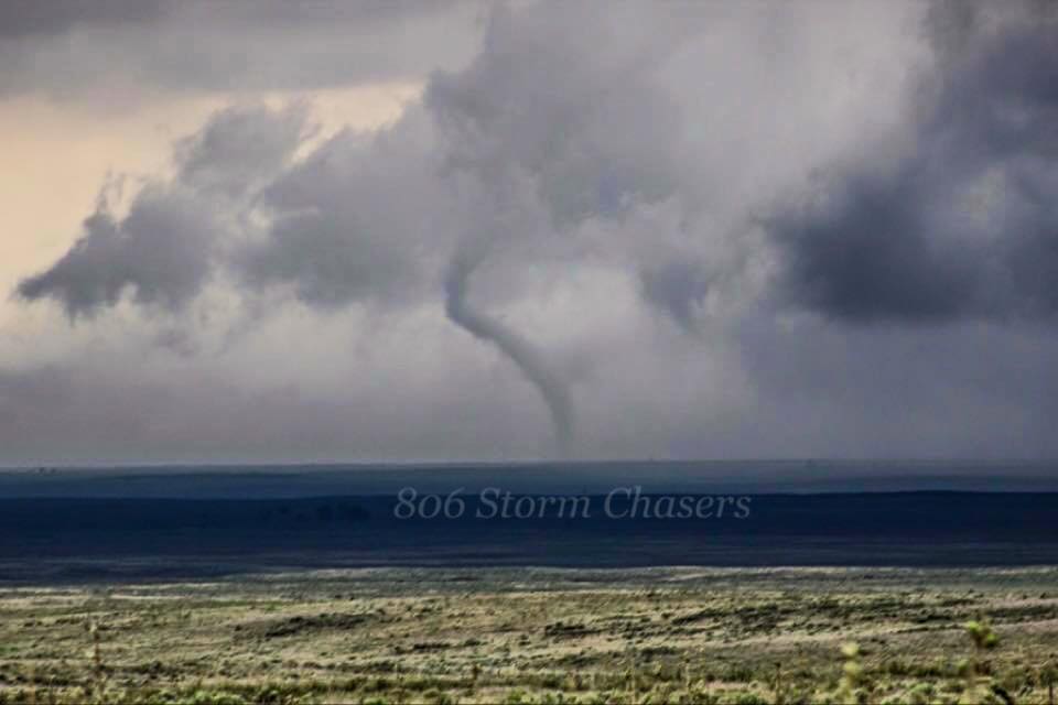
|
||||||||||||||||
|
||||||||||||||||
The Enhanced Fujita (EF) Scale classifies tornadoes into the following categories:
| EF0 Weak 65-85 mph |
EF1 Moderate 86-110 mph |
EF2 Significant 111-135 mph |
EF3 Severe 136-165 mph |
EF4 Extreme 166-200 mph |
EF5 Catastrophic 200+ mph |
 |
|||||
Photos & Video:
 |
 |
 |
 |
| Barn in Deaf Smith County (Courtesy of Emergency Management) |
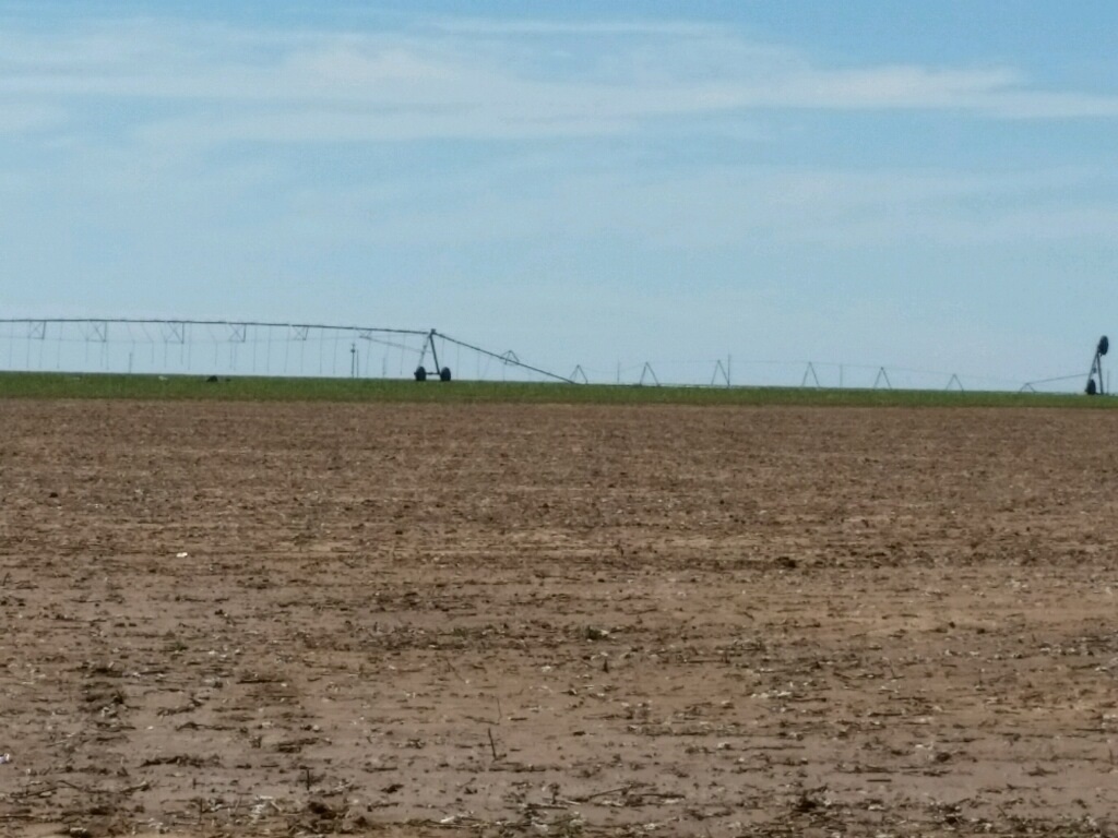
Pivot in Deaf Smith County (Courtesy of Emergency Management) |
Golf Ball Hail in Dalhart (Courtesy of @lathemfarms) |
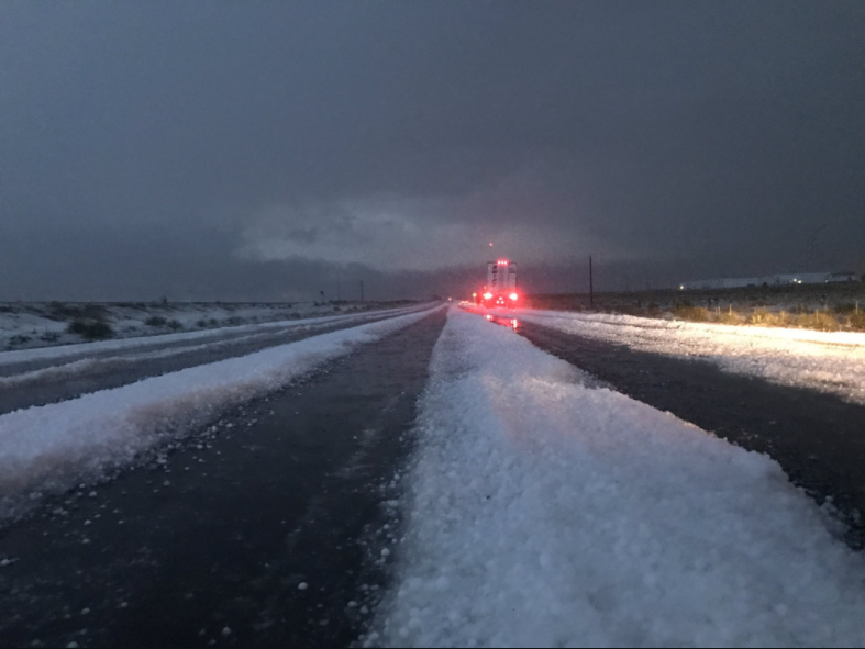
Hail Drift on US-54 S of Dalhart (Courtesy of Quincy Vagell) |
Storm Reports
Interactive Map
Pan, zoom, or click on icons for more information.
PRELIMINARY LOCAL STORM REPORT...SUMMARY
NATIONAL WEATHER SERVICE AMARILLO TX
248 PM CDT MON JUN 26 2017

..TIME...   ...EVENT...      ...CITY LOCATION...     ...LAT.LON...
..DATE...   ....MAG....      ..COUNTY LOCATION..ST.. ...SOURCE....
            ..REMARKS..

0612 PM     TORNADO          6 N KEYES               36.89N 102.24W
06/25/2017                   CIMARRON           OK   STORM CHASER

            LATE REPORT...WEAK AND BRIEF TORNADO OBSERVED. PICTURE
            RECEIVED FROM STORM CHASERS THAT FOLLOWED STORM.

0615 PM     HAIL             KEYES                   36.81N 102.25W
06/25/2017  E2.75 INCH       CIMARRON           OK   EMERGENCY MNGR

            LATE REPORT FROM CIMMARON CTY EM...BASEBALL SIZE HAIL
            REPORTED. STRUCTURAL AND TREE DAMAGE SUSTAINED
            THROUGHOUT KEYES DUE TO WIND AND LARGE HAIL.

0615 PM     TSTM WND DMG     KEYES                   36.81N 102.25W
06/25/2017                   CIMARRON           OK   EMERGENCY MNGR

            LATE REPORT FROM CIMMARON CTY EM...BASEBALL SIZE HAIL
            REPORTED. STRUCTURAL AND TREE DAMAGE SUSTAINED
            THROUGHOUT KEYES DUE TO WIND AND LARGE HAIL.

0624 PM     HAIL             2 N KEYES               36.83N 102.25W
06/25/2017  E2.75 INCH       CIMARRON           OK   STORM CHASER

            BASEBALL SIZE HAIL REPORTED ON NORTH ROAD 430 NORTH OF
            KEYES.

0633 PM     TORNADO          7 ENE BOISE CITY        36.76N 102.38W
06/25/2017                   CIMARRON           OK   LAW ENFORCEMENT

            SHERRIFFS OFFICE REPORTED TORNADO ON THE GROUND AT
            INTERSECTION HWY 64 AMD 56 FROM A LAW ENFORCEMENT
            OFFICER IN THE FIELD.

0644 PM     HAIL             7 SSW KEYES             36.71N 102.29W
06/25/2017  E2.75 INCH       CIMARRON           OK   EMERGENCY MNGR

            LATE REPORT...TENNIS BALL TO BASEBALL SIZED HAIL
            REPORTED THROUGHOUT FARM SOUTH TO SOUTHWEST OF KEYES.
            ALL CROPS ON FARM SUSTAINED HAIL DAMAGE RESULTING IN A
            TOTAL LOSS. LOCATION RELAYED BY CIMMARON CTY EM WITH
            TIME ESTIMATED FROM RADAR.

0805 PM     TSTM WND DMG     5 SE WARE               36.14N 102.63W
06/25/2017                   DALLAM             TX   EMERGENCY MNGR

            CENTER PIVOT IRRIGATION SYSTEM FLIPPED AT THE
            INTERSECTION OF HWY 87 AND 102.

0829 PM     HAIL             3 WSW DALHART           36.04N 102.57W
06/25/2017  M1.75 INCH       HARTLEY            TX   PUBLIC

            SOCIAL MEDIA PICTURE CONFIRMED GOLFBALL SIZED HAIL.

0830 PM     HAIL             4 SW DALHART            36.02N 102.56W
06/25/2017  M2.75 INCH       HARTLEY            TX   STORM CHASER

            LIVE FEED FROM STORM CHASERS SHOWED BASEBALL SIZED HAIL
            .

0830 PM     HAIL             2 NW DALHART            36.08N 102.54W
06/25/2017  E0.88 INCH       DALLAM             TX   FIRE DEPT/RESCUE

            HAIL COVERING THE ROADWAYS AT THE INTERSECTION OF
            FM1727 AND HWY 87 NORTH.

0830 PM     HAIL             DALHART                 36.06N 102.52W
06/25/2017  U0.00 INCH       HARTLEY            TX   EMERGENCY MNGR

            MANY WINDOWS AND CAR WINDOWS BROKEN IN DALHART. TIME
            ESTIMATED.

0833 PM     HAIL             6 SW DALHART            36.00N 102.59W
06/25/2017  M2.75 INCH       HARTLEY            TX   PUBLIC

            HAIL RAINGING FROM GOLFBALL TO BASEBALL SIZE REPORTED
            BY THE PUBLIC SOUTHWEST OF DALHART. PROPERTY DAMAGE FROM
            THE HAIL AND WIND WAS REPORTED AS WELL.

0838 PM     TSTM WND GST     3 SW DALHART            36.03N 102.55W
06/25/2017  M67 MPH          HARTLEY            TX   ASOS

0850 PM     TSTM WND GST     14 SW DALHART           35.91N 102.69W
06/25/2017  M81 MPH          HARTLEY            TX   BROADCAST MEDIA

            FROM THE KVII SCHOOLNET SITE AT OLSON RANCH.

0952 PM     HAIL             SIMMS                   35.03N 102.66W
06/25/2017  E2.50 INCH       DEAF SMITH         TX   EMERGENCY MNGR

1004 PM     TSTM WND GST     1 SE VEGA               35.24N 102.42W
06/25/2017  M72 MPH          OLDHAM             TX   BROADCAST MEDIA

1005 PM     TSTM WND DMG     VEGA                    35.25N 102.43W
06/25/2017                   OLDHAM             TX   EMERGENCY MNGR

            LATE REPORT FROM OLDHAM COUNTY EMERGENCY MANAGER WITH
            DAMAGE TO RVS...CARPORT...AND ABOUT 20 DOWNED POWERLINES
            IN VEGA.

1015 PM     TSTM WND DMG     2 S WILDORADO           35.19N 102.24W
06/25/2017                   OLDHAM             TX   EMERGENCY MNGR

            LATE REPORT FROM OLDHAM COUNTY EMERGENCY OF DOWNED
            POWERLINES ALONG TX ROUTE 809 JUST SOUTH OF WILDORADO.
            TIME ESTIMATED FROM RADAR.

1025 PM     TSTM WND GST     2 ESE WILDORADO         35.21N 102.21W
06/25/2017  M81 MPH          OLDHAM             TX   BROADCAST MEDIA

1040 PM     TSTM WND DMG     8 NW UMBARGER           35.04N 102.20W
06/25/2017                   DEAF SMITH         TX   EMERGENCY MNGR

            LATE REPORT BY EMERGENCY MNGR OF POWER POLE DOWN...
            PART OF ROOF OFF BARN NEAR HWY 809 AND CR 21.

1055 PM     TSTM WND GST     5 ENE HEREFORD          34.86N 102.33W
06/25/2017  M67 MPH          DEAF SMITH         TX   AWOS

1113 PM     FLASH FLOOD      AMARILLO                35.20N 101.82W
06/25/2017                   POTTER             TX   BROADCAST MEDIA

            INTERSTATE 40 AT WASHINGTON CLOSED FOR EAST BOUND AND
            WEST BOUND TRAFFIC.

1114 PM     TSTM WND GST     GOODNIGHT               35.03N 101.19W
06/25/2017  M62 MPH          ARMSTRONG          TX   MESONET
Rain Report
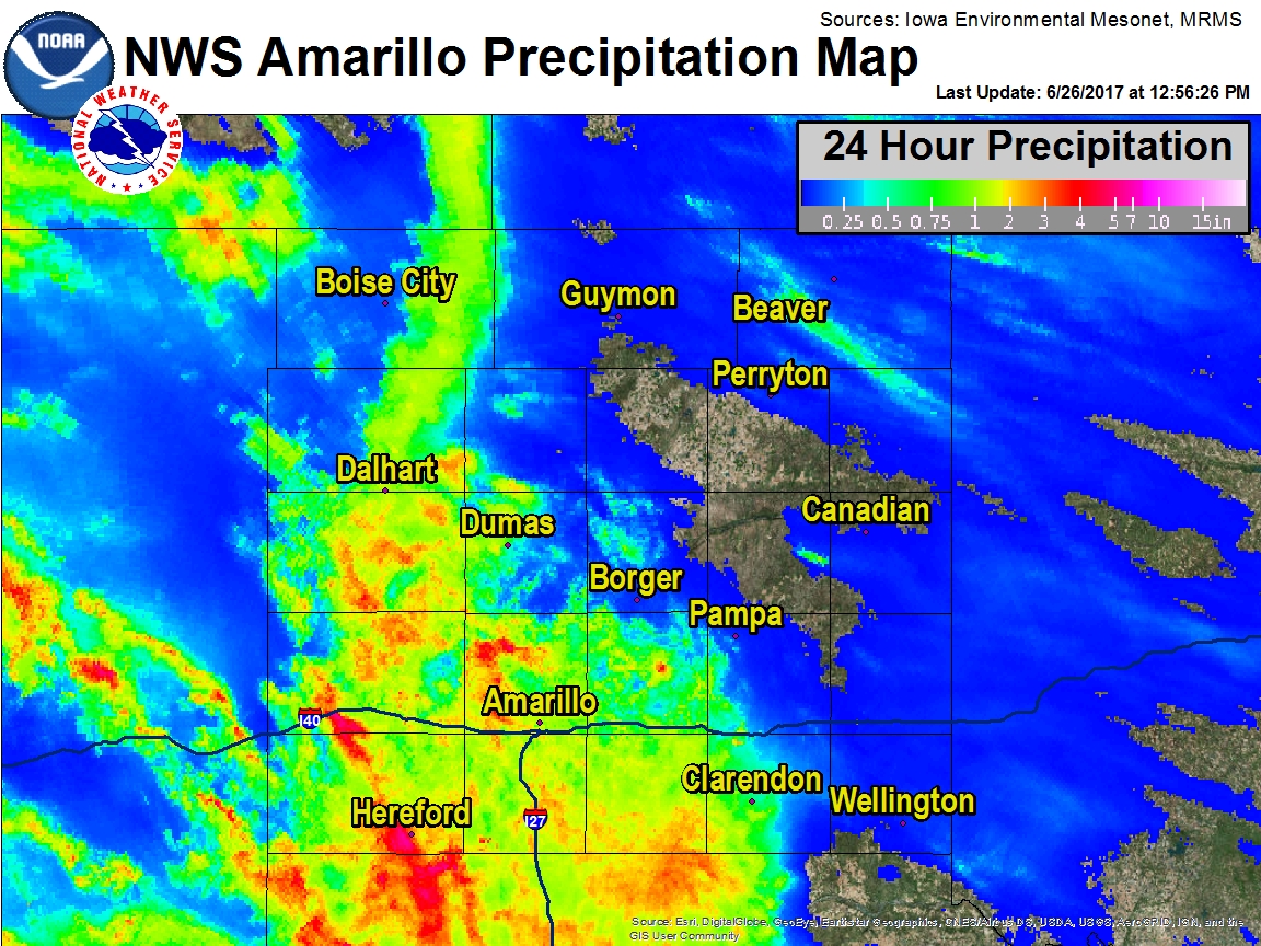 |
| Estimated 24 Hour Rainfall ending at approximately 1:00 pm June 26th |
 |
Media use of NWS Web News Stories is encouraged! Please acknowledge the NWS as the source of any news information accessed from this site. |
|

