
Severe thunderstorms which can bring large hail, damaging winds, and isolated tornadoes will be possible over parts of the central U.S. through this weekend. Thunderstorms with heavy to excessive rainfall moving from Texas into the mid-Mississippi Valley through this weekend may produce areas of flooding. Read More >
Overview
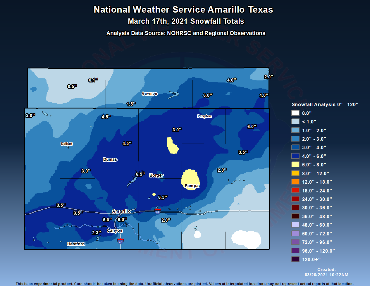
A narrow, but tightly closed low pressure system moved across the Panhandles late on the 16th and into the 17th. Air that was just cold enough to provide snow was on the wrap around (back side) of the storm system. Strong sustained winds ranged in the 25 - 45 mph, gusting into the mid 60 mph range occurred with this storm. These winds in conjunction with moderate to heavy snowfall would create very hazardous winter conditions across the majority of the Panhandles. Widespread areas struggled to stay above 1/2 mile visibility during the event (mainly between 5AM and 2PM), with several areas dropping to a quarter of a mile (near white out conditions) for to 2 to 4 hours. While several reports of white out conditions came in from trained weather spotters, and/or first responders, observations of less than 1/4 mile came in at only a couple sites for a limited amount of time. Some of the snow drifts caused highways to be impassible, as drifts were 2 to 3 feet over the roads, in addition to the already noted very low visibility. Several reports were logged by county officials of jack-knifed semi-trucks, and stranded motorists that needed to be tended to by emergency vehicles and/or wreckers. Snowfall in the northwest Panhandles were anywhere from 1 to 3 inches in the northwest TX Panhandle, to less than an inch in the OK Panhandle. As far as the southwest TX Panhandle in a line up to Beaver County, 2-7 inches of snow fell. And the southeast was spared any snow, but not spared from any wind as Donley, Wheeler, & Collingsworth Counties had high winds.Snow
Highest amounts ranged from the southwest to northeast Panhandles. Little to now snow in the extreme northwest and southeast.
County Incidents/Responses
Reports that have come in from Emergency Managers or County Sheriffs regarding the responses that were needed. (Still awaiting other counties and we'll add them as they report)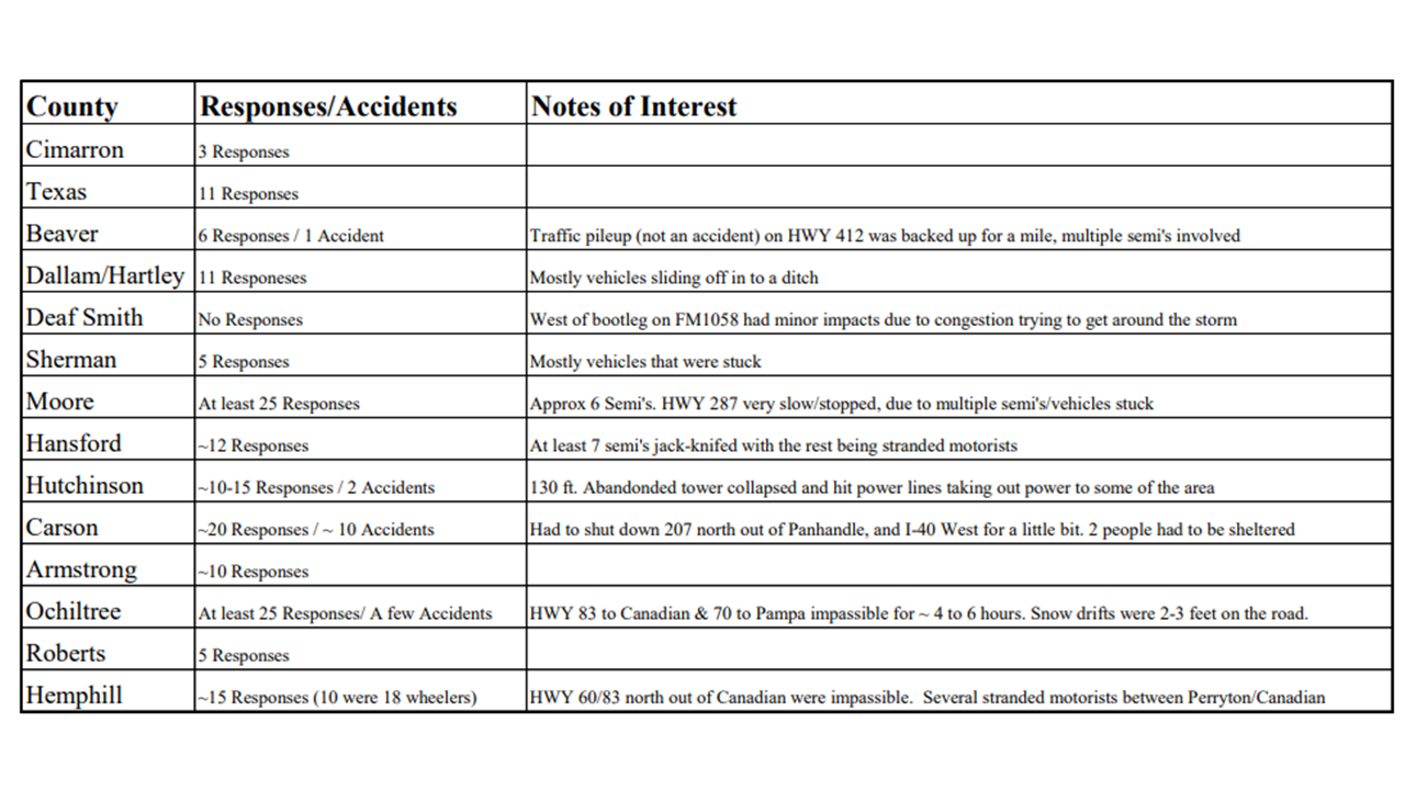
Photos & Video
Header
.jpg) |
.jpg) |
.jpg) |
.jpg) |
| Amarillo, TX (Edith Di Tommaso) |
Amarillo, TX (Sue Bryan Jenkins) |
Bushland, TX (Jamie Loder Hitt) |
Channing, TX (Sandra Richmond) |
.jpg) |
.jpg) |
.jpg) |
.jpg) |
| Dumas, TX (June Fitzgerald Scott) |
Elmwood, OK (Mike Baker) |
Gruver, TX (Kimberly Boyd) |
Guymon, OK (Justin Carnagey) |
.jpg) |
.jpg) |
.jpg) |
.jpg) |
| Miami, TX (Nikki Joann) |
Pampa, TX (Kyng James Hernandez) |
Panhandle, TX (Nikki Biggs) |
Stinnett, TX (Michelle Ann) |
Radar
Loop time from 4 AM through 5 PM.
LT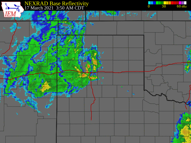
Storm Reports
PRELIMINARY LOCAL STORM REPORT...SUMMARY
NATIONAL WEATHER SERVICE AMARILLO TX
546 AM CDT FRI MAR 19 2021

..TIME...   ...EVENT...      ...CITY LOCATION...     ...LAT.LON...
..DATE...   ....MAG....      ..COUNTY LOCATION..ST.. ...SOURCE....
            ..REMARKS..

1215 AM     NON-TSTM WND GST 3 ENE PERRYTON          36.42N 100.75W
03/17/2021  M51 MPH          OCHILTREE          TX   AWOS

            AWOS STATION KPYX PERRYTON (AWOS).

0141 AM     NON-TSTM WND GST 1 WSW GUYMON            36.68N 101.50W
03/17/2021  M52 MPH          TEXAS              OK   ASOS

            ASOS STATION KGUY GUYMON (ASOS).

0352 AM     HIGH SUST WINDS  4 WNW STRATFORD         36.36N 102.14W
03/17/2021  M44 MPH          SHERMAN            TX   MESONET


0420 AM     HIGH SUST WINDS  3 SSE BOISE CITY        36.69N 102.49W
03/17/2021  M45 MPH          CIMARRON           OK   MESONET


0524 AM     SNOW             DALHART                 36.06N 102.51W
03/17/2021  E1.3 INCH        DALLAM             TX   LAW ENFORCEMENT

            1 TO 1.5 INCHES OF SNOW ON THE GROUND. STILL
            SNOWING.

0603 AM     NON-TSTM WND GST 11 SSW ROMERO           35.58N 103.01W
03/17/2021  M58 MPH          OLDHAM             TX   MESONET


0631 AM     NON-TSTM WND GST 6 ENE AMARILLO          35.22N 101.72W
03/17/2021  M58 MPH          POTTER             TX   ASOS


0702 AM     NON-TSTM WND GST 3 NNW PALO DURO CANYON  34.99N 101.69W
03/17/2021  M59 MPH          RANDALL            TX   MESONET

            MESONET STATION 68 PALO DURO CANYON SP RIM.

0719 AM     NON-TSTM WND GST 10 ENE PALO DURO CANYON 34.98N 101.50W
03/17/2021  M58 MPH          ARMSTRONG          TX   MESONET

            MESONET STATION 74 CLAUDE 12SW.

0735 AM     HIGH SUST WINDS  5 ENE HEREFORD          34.86N 102.33W
03/17/2021  M43 MPH          DEAF SMITH         TX   AWOS


0800 AM     SNOW             TEXLINE                 36.37N 103.02W
03/17/2021  E2.0 INCH        DALLAM             TX   PUBLIC


0800 AM     SNOW             SPEARMAN                36.19N 101.20W
03/17/2021  E3.0 INCH        HANSFORD           TX   TRAINED SPOTTER


0815 AM     SNOW             1 NNW STRATFORD         36.35N 102.08W
03/17/2021  E4.5 INCH        SHERMAN            TX   TRAINED SPOTTER


0830 AM     SNOW             1 ENE TEXHOMA           36.51N 101.77W
03/17/2021  E1.5 INCH        TEXAS              OK   PUBLIC


0857 AM     HIGH SUST WINDS  1 NNW STINNETT          35.84N 101.45W
03/17/2021  M52 MPH          HUTCHINSON         TX   MESONET


0859 AM     NON-TSTM WND GST 2 N STINNETT            35.84N 101.45W
03/17/2021  M61 MPH          HUTCHINSON         TX   MESONET

            MESONET STATION 104 STINNETT 1NNW.

0915 AM     HIGH SUST WINDS  GOODNIGHT               35.03N 101.19W
03/17/2021  M46 MPH          ARMSTRONG          TX   MESONET


0935 AM     NON-TSTM WND GST 6 SE WELLINGTON         34.80N 100.14W
03/17/2021  M60 MPH          COLLINGSWORTH      TX   MESONET


0951 AM     SNOW             4 SSW AMARILLO          35.15N 101.86W
03/17/2021  M4.5 INCH        RANDALL            TX   NWS EMPLOYEE

            HEAVY SNOW WAS STILL FALLING AT TIME OF
            REPORT WITH VISIBILITY AS LOW AS 100 FEET.

0955 AM     NON-TSTM WND GST 2 WNW LAKE MCCLELLAN    35.23N 100.90W
03/17/2021  M58 MPH          GRAY               TX   MESONET

            MESONET STATION 121 LAKE MCCLELLAN 2NW.

1022 AM     NON-TSTM WND DMG 6 SSW AMARILLO          35.13N 101.88W
03/17/2021                   RANDALL            TX   EMERGENCY MNGR

            DOWNED POWER LINES REPORTED.

1028 AM     HIGH SUST WINDS  6 SE WELLINGTON         34.79N 100.14W
03/17/2021  M48 MPH          COLLINGSWORTH      TX   MESONET


1038 AM     NON-TSTM WND GST 3 W DOZIER              35.08N 100.40W
03/17/2021  M58 MPH          COLLINGSWORTH      TX   MESONET


1043 AM     NON-TSTM WND DMG 1 S BORGER              35.65N 101.40W
03/17/2021                   HUTCHINSON         TX   EMERGENCY MNGR

            A 130 FOOT RADIO TOWER COLLAPSED IN SOUTH
            BORGER.

1047 AM     HIGH SUST WINDS  11 SSW ROMERO           35.58N 103.01W
03/17/2021  M44 MPH          OLDHAM             TX   MESONET


1054 AM     SNOW             5 WSW AMARILLO          35.17N 101.91W
03/17/2021  M5.0 INCH        RANDALL            TX   PUBLIC

            REPORT RECEIVED VIA FACEBOOK WITH PICTURE.

1101 AM     HIGH SUST WINDS  3 NNE UMBARGER          34.99N 102.08W
03/17/2021  M47 MPH          RANDALL            TX   MESONET


1113 AM     HEAVY SNOW       4 SSW AMARILLO          35.15N 101.86W
03/17/2021  M7.5 INCH        RANDALL            TX   NWS EMPLOYEE

            CORRECTS PREVIOUS SNOW REPORT FROM 4 SSW
            AMARILLO. MODERATE SNOW WAS STILL FALLING AT
            TIME OF REPORT.

1123 AM     HEAVY SNOW       FRITCH                  35.64N 101.60W
03/17/2021  M6.5 INCH        HUTCHINSON         TX   PUBLIC

            SNOW DRIFTS UP TO 1.5 FEET DEEP, LIGHT SNOW
            WAS FALLING AT TIME OF REPORT.

1127 AM     HIGH SUST WINDS  2 NW LAKE MCCLELLAN     35.24N 100.90W
03/17/2021  M48 MPH          GRAY               TX   MESONET


1127 AM     SNOW             PAMPA                   35.55N 100.96W
03/17/2021  M4.0 INCH        GRAY               TX   TRAINED SPOTTER

            .

1142 AM     HIGH SUST WINDS  4 E VEGA                35.25N 102.36W
03/17/2021  M47 MPH          OLDHAM             TX   MESONET


1151 AM     SNOW             5 SW AMARILLO           35.16N 101.88W
03/17/2021  M5.5 INCH        RANDALL            TX   BROADCAST MEDIA

            LOCAL NEWS STATION CHIEF METEOROLOGIST
            MEASURED 5.5 INCHES OF SNOW NEAR 45TH AVE
            AND WESTERN ST IN AMARILLO.

1156 AM     SNOW             2 S AMARILLO            35.17N 101.82W
03/17/2021  M4.0 INCH        RANDALL            TX   NWS EMPLOYEE

            DRIFTS UP TO 9 INCHES DEEP.

1202 PM     SNOW             1 S PAMPA               35.54N 100.97W
03/17/2021  M4.0 INCH        GRAY               TX   TRAINED SPOTTER

            .

1202 PM     SNOW             CANADIAN                35.91N 100.38W
03/17/2021  M3.5 INCH        HEMPHILL           TX   TRAINED SPOTTER


1202 PM     SNOW             PERRYTON                36.39N 100.80W
03/17/2021  M3.0 INCH        OCHILTREE          TX   TRAINED SPOTTER


1203 PM     HEAVY SNOW       1 W AMARILLO            35.20N 101.83W
03/17/2021  M7.0 INCH        POTTER             TX   BROADCAST MEDIA

            BROADCAST METEOROLOGIST MEASURED 7 INCHES AT
            LOCAL NEWS STATION.

1206 PM     SNOW             VEGA                    35.24N 102.43W
03/17/2021  M3.5 INCH        OLDHAM             TX   TRAINED SPOTTER


1209 PM     SNOW             8 ESE BUSHLAND          35.13N 101.94W
03/17/2021  M5.0 INCH        RANDALL            TX   NWS EMPLOYEE

            AVERAGE MEASUREMENT WITH DRIFTS UP TO 2 TO 3
            FEET DEEP.

1210 PM     HIGH SUST WINDS  7 E BORGER              35.66N 101.28W
03/17/2021  M43 MPH          HUTCHINSON         TX   MESONET


1211 PM     HIGH SUST WINDS  6 E CANADIAN            35.91N 100.28W
03/17/2021  M48 MPH          HEMPHILL           TX   MESONET


1218 PM     HEAVY SNOW       4 SSW AMARILLO          35.15N 101.86W
03/17/2021  M8.5 INCH        RANDALL            TX   NWS EMPLOYEE

            SNOW WAS STILL FALLING AT TIME OF REPORT.

1218 PM     SNOW             7 WSW AMARILLO          35.17N 101.93W
03/17/2021  M5.0 INCH        RANDALL            TX   BROADCAST MEDIA

            LOCAL BROADCAST CHIEF METEOROLOGIST MEASURED
            5 INCHES OF SNOW WITH PICTURE.

1218 PM     HEAVY SNOW       7 WSW AMARILLO          35.17N 101.93W
03/17/2021  M5.0 INCH        RANDALL            TX   BROADCAST MEDIA

            LOCAL BROADCAST CHIEF METEOROLOGIST MEASURED
            5 INCHES OF SNOW WITH PICTURE.

1224 PM     HIGH SUST WINDS  6 WSW ADRIAN            35.24N 102.76W
03/17/2021  M43 MPH          OLDHAM             TX   MESONET


1231 PM     HIGH SUST WINDS  3 W DOZIER              35.08N 100.40W
03/17/2021  M45 MPH          COLLINGSWORTH      TX   MESONET


1241 PM     HIGH SUST WINDS  12 SW CLAUDE            34.98N 101.51W
03/17/2021  M47 MPH          ARMSTRONG          TX   MESONET


1241 PM     HIGH SUST WINDS  2 WSW CLARENDON         34.93N 100.92W
03/17/2021  M43 MPH          DONLEY             TX   MESONET


1244 PM     HIGH SUST WINDS  11 WNW BOOTLEG          34.89N 102.99W
03/17/2021  M42 MPH          DEAF SMITH         TX   MESONET


1244 PM     HEAVY SNOW       1 W AMARILLO            35.20N 101.83W
03/17/2021  M8.0 INCH        POTTER             TX   BROADCAST MEDIA

            UPDATED TO 8 INCHES WITH SNOW ENDING.

1259 PM     HIGH SUST WINDS  7 SSE AMARILLO          35.11N 101.77W
03/17/2021  M45 MPH          RANDALL            TX   MESONET


0100 PM     SNOW             7 ENE AMARILLO          35.23N 101.71W
03/17/2021  M5.7 INCH        POTTER             TX   OFFICIAL NWS OBS


0100 PM     HEAVY SNOW       4 SW AMARILLO           35.16N 101.88W
03/17/2021  M6.0 INCH        RANDALL            TX   BROADCAST MEDIA

            LOCAL BROADCAST METEOROLOGIST MEASURED 6
            INCHES OF SNOW.

0100 PM     HEAVY SNOW       4 SSW AMARILLO          35.15N 101.86W
03/17/2021  M8.5 INCH        RANDALL            TX   NWS EMPLOYEE

            TWO TO THREE FOOT DRIFTS AND SNOW HAS ENDED.
            FINAL UPDATE.

0102 PM     HIGH SUST WINDS  15 NNW AMARILLO         35.40N 101.92W
03/17/2021  M44 MPH          POTTER             TX   MESONET


0105 PM     HIGH SUST WINDS  4 NNW PALO DURO CANYON  35.01N 101.71W
03/17/2021  M41 MPH          RANDALL            TX   MESONET


0106 PM     HIGH SUST WINDS  9 NNE AMARILLO          35.32N 101.76W
03/17/2021  M40 MPH          POTTER             TX   MESONET


0119 PM     SNOW             3 E CANYON              34.98N 101.87W
03/17/2021  M3.8 INCH        RANDALL            TX   NWS EMPLOYEE

            TOTAL SNOWFALL. 0.74 OF A INCH OF LIQUID FOR
            THE EVENT.

0128 PM     HIGH SUST WINDS  9 NW WAKA               36.37N 101.17W
03/17/2021  M44 MPH          HANSFORD           TX   MESONET


0130 PM     HIGH SUST WINDS  1 E MCLEAN              35.23N 100.58W
03/17/2021  M40 MPH          GRAY               TX   MESONET


0134 PM     HIGH SUST WINDS  1 WSW BOYS RANCH        35.51N 102.27W
03/17/2021  M41 MPH          OLDHAM             TX   MESONET


0138 PM     HIGH SUST WINDS  9 ENE PALO DURO CANYON  34.99N 101.53W
03/17/2021  M49 MPH          ARMSTRONG          TX   MESONET


0152 PM     BLIZZARD         CANYON                  34.98N 101.92W
03/17/2021                   RANDALL            TX   PUBLIC

            3.5 SNOW AND 0.68 LIQUID.

0222 PM     HEAVY SNOW       PAMPA                   35.55N 100.96W
03/17/2021  M7.2 INCH        GRAY               TX   TRAINED SPOTTER

            SPOTTER SENT VIA TWITTER THAT 7.2 INCHES OF
            SNOW HAD FALLEN WITH 19 INCH DRIFTS IN YARD.

0231 PM     SNOW             BEAVER                  36.81N 100.52W
03/17/2021  M4.0 INCH        BEAVER             OK   EMERGENCY MNGR


0231 PM     SNOW             SLAPOUT                 36.62N 100.12W
03/17/2021  M4.0 INCH        BEAVER             OK   EMERGENCY MNGR


0231 PM     SNOW             GATE                    36.85N 100.06W
03/17/2021  M2.0 INCH        BEAVER             OK   EMERGENCY MNGR


0231 PM     HEAVY SNOW       BRYANS CORNER           36.62N 100.82W
03/17/2021  M6.0 INCH        BEAVER             OK   EMERGENCY MNGR


0625 PM     SNOW             HEREFORD                34.82N 102.40W
03/17/2021  E2.0 INCH        DEAF SMITH         TX   EMERGENCY MNGR

            FINAL SNOW AMOUNT.

0630 PM     SNOW             CLAUDE                  35.11N 101.36W
03/17/2021  E2.0 INCH        ARMSTRONG          TX   LAW ENFORCEMENT

            FINAL SNOW AMOUNT.

0630 PM     SNOW             DAWN                    34.91N 102.20W
03/17/2021  E2.3 INCH        DEAF SMITH         TX   FIRE DEPT/RESCUE

            FINAL SNOW AMOUNT.

0645 PM     SNOW             DUMAS                   35.86N 101.96W
03/17/2021  E4.0 INCH        MOORE              TX   DEPT OF HIGHWAYS

            FINAL SNOW AMOUNT.

0650 PM     SNOW             SUNRAY                  36.02N 101.82W
03/17/2021  E4.5 INCH        MOORE              TX   FIRE DEPT/RESCUE

            FINAL SNOW AMOUNT.

0700 PM     SNOW             ADRIAN                  35.28N 102.66W
03/17/2021  E3.5 INCH        OLDHAM             TX   PUBLIC

            FINAL SNOW AMOUNT.

0710 PM     SNOW             PANHANDLE               35.35N 101.38W
03/17/2021  E6.5 INCH        CARSON             TX   COUNTY OFFICIAL

            FINAL SNOW AMOUNT.

0800 PM     SNOW             CHANNING                35.68N 102.33W
03/17/2021  M3.0 INCH        HARTLEY            TX   FIRE DEPT/RESCUE

            FINAL SNOW AMOUNT.

0900 PM     SNOW             LIPSCOMB                36.23N 100.27W
03/17/2021  E6.0 INCH        LIPSCOMB           TX   LAW ENFORCEMENT

            FINAL SNOW AMOUNT.

0910 PM     SNOW             MIAMI                   35.69N 100.64W
03/17/2021  E2.0 INCH        ROBERTS            TX   LAW ENFORCEMENT

            FINAL SNOW AMOUNT.


&&
|
|
||
| US Dept of Commerce National Oceanic and Atmospheric Administration National Weather Service 1325 East West Highway Silver Spring, MD 20910 Page Author: NWSChat Administration Team |
Disclaimer Information Quality Credits Glossary |
Privacy Policy Freedom of Information Act (FOIA) About Us Career Opportunities |
 |
Media use of NWS Web News Stories is encouraged! Please acknowledge the NWS as the source of any news information accessed from this site. |
|

