
Severe weather and flooding threats will continue for portions of the central U.S. through Thursday, focused from the central High Plains to the Mid-Mississippi Valley. Hot and dry conditions will fuel fire weather concerns for the Intermountain West, and dry thunderstorms may spark additional wildfires. Dangerous heat will build across the southern U.S. Friday into the weekend. Read More >
Overview
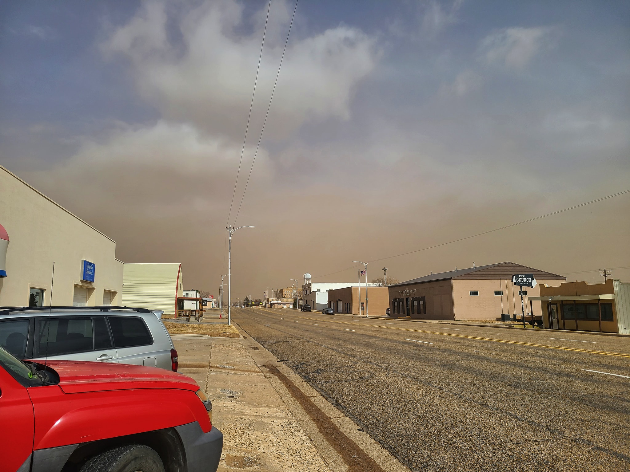
The first in what became a series of strong upper level systems passed northeast over the Panhandles on February 14th. The upper level system rapidly strengthened as it passed to the northeast, leading to the development of a corridor of very intense winds out of the north on the back side of the system. These damaging wind gusts, as high as 84 mph at the Guymon airport, led to a dust storm the northeastern Panhandles. Farther south, strong gusts to around 60 to 70 mph out of the southwest occurred.
Photos & Video
| Video of visible satellite during the February 14, 2023 dust storm event. Try slowing it down using the settings gear inside the player. (NOAA GOES) |
 |
 |
 |
 |
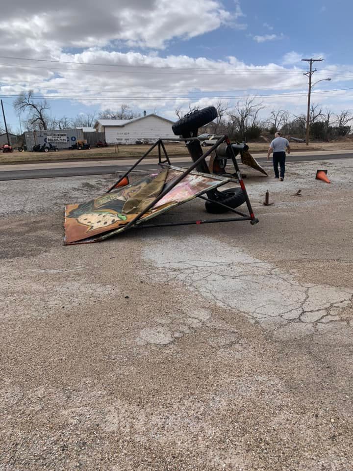
| Sign blown over in Clarendon, Texas (Amanda Ann-Street Hope) |
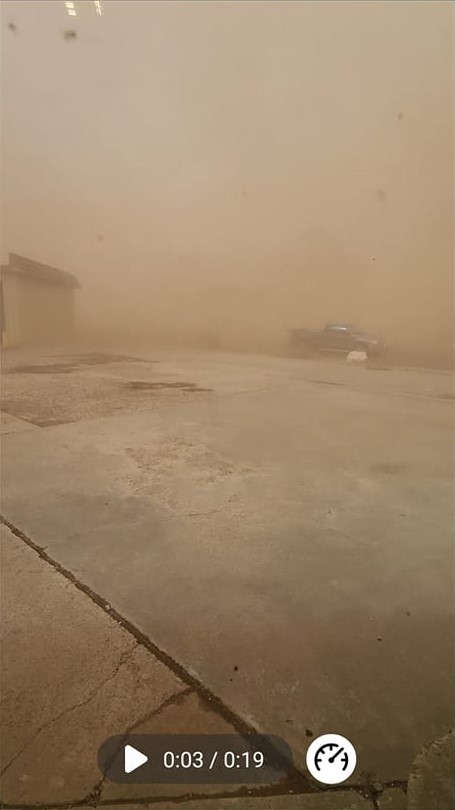
Blowing dust in Hooker, Oklahoma (Chelsey Snook) |
Blowing dust in Spearman, Texas (Cherise Magdaleno) |
Blowing dust in Tyrone, Oklahoma (Dallas Smith) |
 |
 |
 |
 |
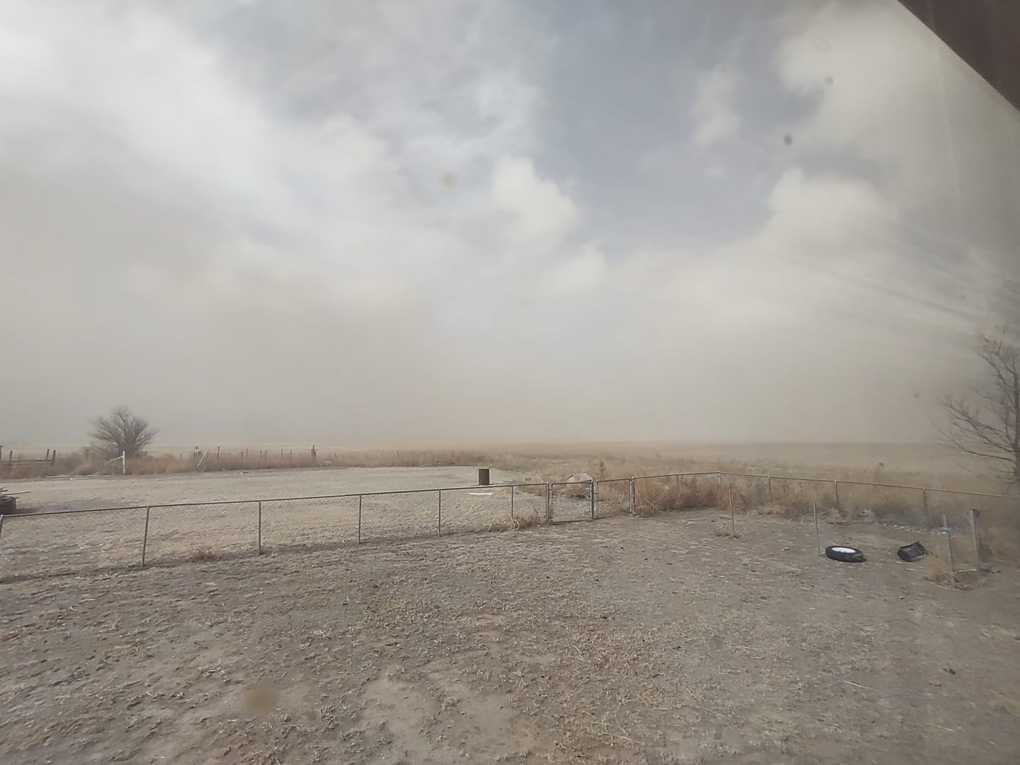
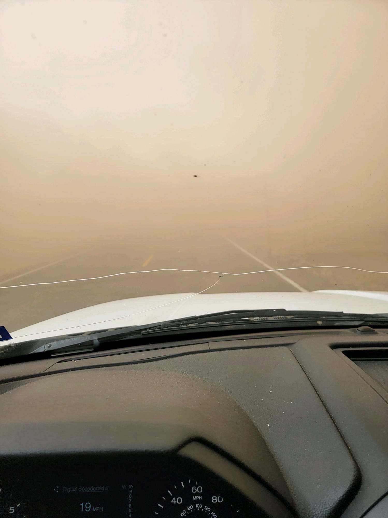
| Blowing dust in Stinnett, Texas (Dawn Davis) |
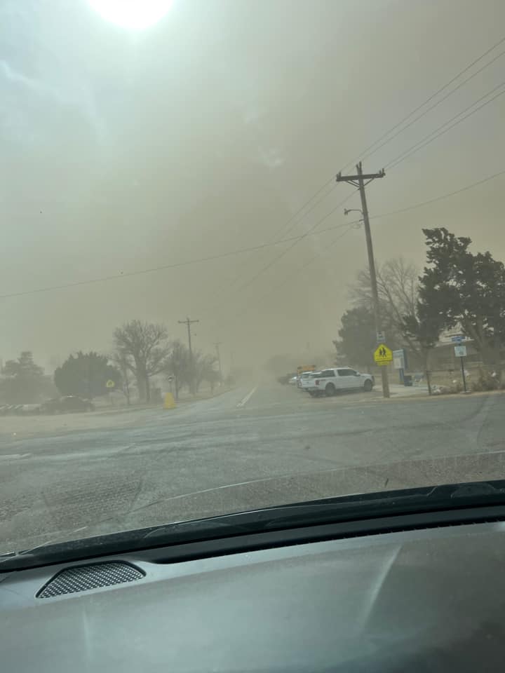
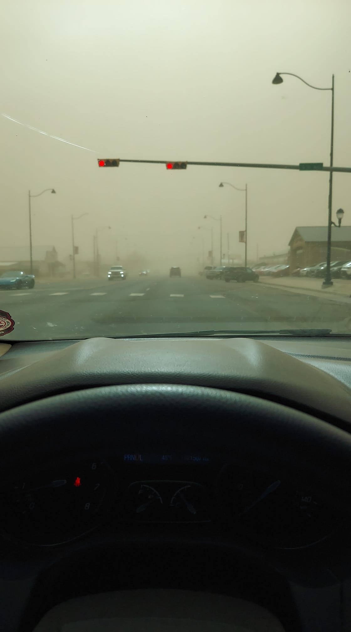
Very low visibility in Guymon, Oklahoma due to blowing dust (Dustin Sides Valdez) |
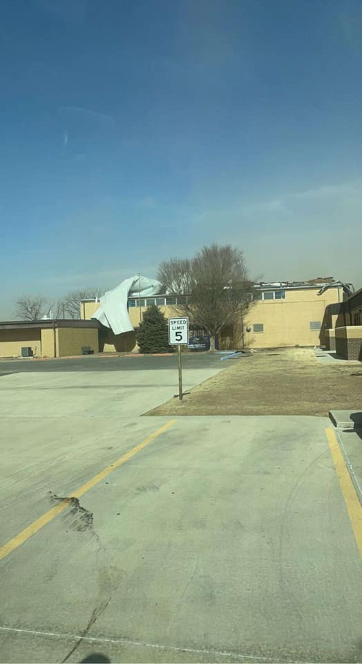
Roof peeled back on the Goodwell, Oklahoma gym due to high winds (Jaci Lujan Quintana) |
Blowing dust in Perryton, Texas (Stephanie Boston) |
Storm Reports
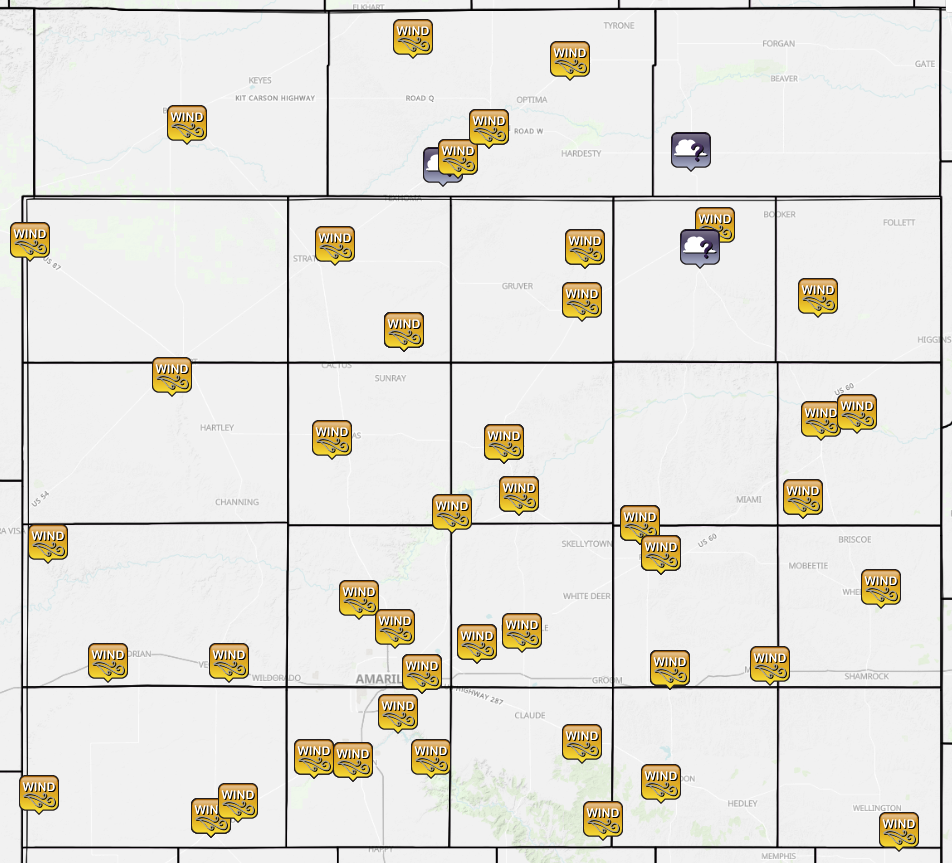 |
| High winds were reported across the Panhandles with dust storms occurring in the north central and northeastern Panhandles. (Reports collected by NWS Amarillo; map by Iowa Environmental Mesonet) |
| Report Time (CST) | County | Location | State | Event Type | Magnitude | Source | Lat | Lon | Remark |
|---|---|---|---|---|---|---|---|---|---|
| 2023/02/14 11:49 | TEXAS | 1 WSW GUYMON | OK | NON-TSTM WND GST | 84 | ASOS | 36.68 | -101.5 | FIRST WIND GUST EXCEEDING 58 MPH STARTED BEGAN ART 1045CST. MAX WIND GUST OF 84 MPH OCCURRED AT 1149CST. STRONG WIND GUSTS STILL OCCURRING AT THIS TIME. |
| 2023/02/14 11:40 | TEXAS | 2 ENE GOODWELL | OK | NON-TSTM WND GST | 78 | MESONET | 36.6 | -101.6 | WIND GUSTS STARTED TO EXCEED 58 MPH AT 1110CST WITH A PEAK GUST OF 78 MPH OCCURRING AT 1140CST. STRONG WIND GUSTS STILL OCCURRING AT THIS TIME. |
| 2023/02/14 11:18 | SHERMAN | 9 NNE SUNRAY | TX | NON-TSTM WND GST | 77 | MESONET | 36.14 | -101.78 | GUSTS REACHED 58 MPH AT 1005 AM CST AND PEAK GUST OR 77 MPH OCCURRED AT 1118 AM CST. SUSTAINED WINDS OF 40 MPH STARTED AT 938 AM AND PEAKED AT 64 MPH AT 1118 AM CST. |
| 2023/02/14 13:16 | HEMPHILL | 6 ESE LORA | TX | NON-TSTM WND GST | 76 | MESONET | 35.69 | -100.46 | PEAK GUST OCCURRED AT 116 PM CST. FIRST WIND GUST OCCURRED AT 1137 AM AND GUSTS ENDED AT 141 PM CST. FIRST SUSTAINED 40 MPH WAS AT 1111 AM, PEAKING AT 63 MPH AT 106 PM, AND ENDING BY 205 PM CST. |
| 2023/02/14 12:00 | TEXAS | 1 WSW HOOKER | OK | NON-TSTM WND GST | 75 | MESONET | 36.86 | -101.23 | PEAK GUST AT 1210 PM CST. |
| 2023/02/14 11:20 | TEXAS | 12 NE EVA | OK | NON-TSTM WND GST | 72 | MESONET | 36.92 | -101.75 | |
| 2023/02/14 10:46 | GRAY | 2 ESE PAMPA | TX | NON-TSTM WND GST | 72 | MESONET | 35.54 | -100.93 | PEAK GUST OCCURRED AT 1154 AM CST. |
| 2023/02/14 12:16 | HANSFORD | 9 NW WAKA | TX | NON-TSTM WND GST | 72 | MESONET | 36.36 | -101.18 | PEAK GUST OCCURRED AT 1216 PM CST. FIRST GUST WAS AT 1124 AM; LAST GUST AT 1231 PM CST. FIRST SUSTAINED WAS AT 1039 AM, PEAKING AT 60 MPH AT 1207 PM, AND ENDING AT 102 PM CST. |
| 2023/02/14 12:15 | HANSFORD | 2 N SPEARMAN | TX | NON-TSTM WND GST | 70 | MESONET | 36.22 | -101.19 | MAJOR SAMUEL B CORNELIUS FIELD |
| 2023/02/14 13:43 | HEMPHILL | 6 E CANADIAN | TX | NON-TSTM WND GST | 68 | MESONET | 35.92 | -100.28 | FIRST GUSTS STARTED AT 121 PM CST AND PEAKED AT 68 MPH AT 143 PM, AND ENDED AT 159 PM CST. FIRST SUSTAINED STARTED AT 1215 PM, PEAKED AT 53 MPH AT 137 PM, AND ENDED AT 220 PM CST. |
| 2023/02/14 11:10 | HUTCHINSON | 3 N BORGER | TX | NON-TSTM WND GST | 67 | ASOS | 35.7 | -101.4 | PEAK GUST OCCURRED AT 1140 AM CST. |
| 2023/02/14 12:14 | GRAY | 2 WNW LAKE MCCLELLAN | TX | NON-TSTM WND GST | 66 | MESONET | 35.23 | -100.9 | PEAK GUST AT 12:14 PM CST. GUSTS STARTED AT 1035 AM AND ENDED AT 1232 PM CST. SUSTAINED WINDS STARTED AT 959 AM, PEAKED AT 55 MPH AT 1220 PM, AND ENDED AT 122 PM CST. |
| 2023/02/14 09:55 | RANDALL | 1 W CANYON | TX | NON-TSTM WND GST | 64 | MESONET | 34.98 | -101.95 | FIRST GUST, 60 MPH AT 0945CST. HIGHEST GUST, 64 MPH AT 0955CST. |
| 2023/02/14 11:44 | HUTCHINSON | 2 N STINNETT | TX | NON-TSTM WND GST | 64 | MESONET | 35.84 | -101.45 | PEAK GUST OCCURRED AT 11:45 AM CST. |
| 2023/02/14 12:20 | DONLEY | 2 WSW CLARENDON | TX | NON-TSTM WND GST | 64 | MESONET | 34.92 | -100.93 | |
| 2023/02/14 13:15 | OCHILTREE | 3 ENE PERRYTON | TX | NON-TSTM WND GST | 64 | AWOS | 36.42 | -100.75 | |
| 2023/02/14 11:42 | POTTER | 6 E AMARILLO | TX | NON-TSTM WND GST | 64 | ASOS | 35.22 | -101.72 | PEAK WIND GUST OCCURRED AT 1142 AM CST. |
| 2023/02/14 12:49 | COLLINGSWORTH | 6 SE WELLINGTON | TX | NON-TSTM WND GST | 64 | MESONET | 34.79 | -100.14 | |
| 2023/02/14 12:30 | GRAY | 1 ENE MCLEAN | TX | NON-TSTM WND GST | 63 | MESONET | 35.24 | -100.57 | |
| 2023/02/14 13:52 | WHEELER | 4 E WHEELER | TX | NON-TSTM WND GST | 63 | MESONET | 35.45 | -100.2 | |
| 2023/02/14 12:00 | ARMSTRONG | GOODNIGHT | TX | NON-TSTM WND GST | 62 | MESONET | 35.03 | -101.19 | PEAK GUST OCCURRED AT 1203 PM CST. |
| 2023/02/14 11:55 | GRAY | 5 NNW PAMPA | TX | NON-TSTM WND GST | 61 | AWOS | 35.62 | -101 | PEAK GUST AT 1155 AM CST. |
| 2023/02/14 13:34 | LIPSCOMB | 8 W LIPSCOMB | TX | NON-TSTM WND GST | 61 | MESONET | 36.23 | -100.41 | |
| 2023/02/14 11:29 | OLDHAM | 11 S ROMERO | TX | NON-TSTM WND GST | 60 | MESONET | 35.57 | -102.96 | |
| 2023/02/14 10:45 | DEAF SMITH | 2 WNW HEREFORD | TX | NON-TSTM WND GST | 60 | MESONET | 34.83 | -102.42 | PEAK GUST OCCURRED AT 1045 AM CST. |
| 2023/02/14 11:29 | CARSON | 3 SE PANTEX | TX | NON-TSTM WND GST | 60 | MESONET | 35.3 | -101.54 | FIRST WIND GUST OF 58 MPH PLUS, 1033CST. |
| 2023/02/14 10:45 | DEAF SMITH | 5 NE HEREFORD | TX | NON-TSTM WND GST | 60 | AWOS | 34.87 | -102.33 | |
| 2023/02/14 12:28 | ARMSTRONG | 15 WSW CLARENDON | TX | NON-TSTM WND GST | 59 | MESONET | 34.82 | -101.12 | |
| 2023/02/14 10:20 | RANDALL | 3 NNE UMBARGER | TX | NON-TSTM WND GST | 59 | MESONET | 34.99 | -102.08 | FIRST WIND GUST OF 58 MPH PLUS AT 1020CST. |
| 2023/02/14 11:06 | SHERMAN | 4 ENE STRATFORD | TX | NON-TSTM WND GST | 59 | MESONET | 36.37 | -102.01 | |
| 2023/02/14 11:28 | CARSON | 1 SSW PANHANDLE | TX | NON-TSTM WND GST | 58 | MESONET | 35.33 | -101.39 | |
| 2023/02/14 11:59 | RANDALL | 3 NNW PALO DURO CANYON | TX | NON-TSTM WND GST | 58 | MESONET | 34.99 | -101.69 | |
| 2023/02/14 11:37 | MOORE | 3 WSW DUMAS | TX | NON-TSTM WND GST | 58 | AWOS | 35.85 | -102.02 | |
| 2023/02/14 10:41 | HARTLEY | 4 SSW DALHART | TX | NON-TSTM WND GST | 58 | ASOS | 36.02 | -102.55 | |
| 2023/02/14 13:15 | HEMPHILL | 1 SW CANADIAN | TX | HIGH SUST WINDS | 47 | AWOS | 35.9 | -100.4 | |
| 2023/02/14 10:01 | RANDALL | 4 NNW LAKE TANGLEWOOD | TX | HIGH SUST WINDS | 47 | MESONET | 35.11 | -101.8 | |
| 2023/02/14 11:34 | POTTER | 10 ESE VALLEY DE ORO | TX | HIGH SUST WINDS | 43 | MESONET | 35.42 | -101.93 | |
| 2023/02/14 12:34 | MOORE | 2 WNW FRITCH | TX | HIGH SUST WINDS | 43 | MESONET | 35.65 | -101.62 | |
| 2023/02/14 09:14 | DEAF SMITH | 11 WNW BOOTLEG | TX | HIGH SUST WINDS | 42 | MESONET | 34.89 | -102.99 | |
| 2023/02/14 09:33 | OLDHAM | 4 E VEGA | TX | HIGH SUST WINDS | 42 | MESONET | 35.25 | -102.36 | |
| 2023/02/14 07:49 | OLDHAM | 6 WSW ADRIAN | TX | HIGH SUST WINDS | 41 | MESONET | 35.25 | -102.76 | |
| 2023/02/14 10:01 | DALLAM | TEXLINE 2 N | TX | HIGH SUST WINDS | 41 | MESONET | 36.38 | -103.02 | |
| 2023/02/14 10:05 | CIMARRON | 3 SSE BOISE CITY | OK | HIGH SUST WINDS | 40 | MESONET | 36.69 | -102.5 | |
| 2023/02/14 11:51 | POTTER | 9 N AMARILLO | TX | HIGH SUST WINDS | 40 | MESONET | 35.34 | -101.81 | |
| 2023/02/14 11:34 | TEXAS | 1 SW GOODWELL | OK | DUST STORM | EMERGENCY MNGR | 36.58 | -101.65 | NEAR ZERO VISIBILITY FROM TEXOMA TO OPTIMA ON HIGHWAY 54. MAJOR VEHICLE ACCIDENT REPORTED JUST WEST OF GOODWELL. HIGHWAY CLOSED. | |
| 2023/02/14 14:30 | BEAVER | 1 WSW BRYANS CORNER | OK | DUST STORM | FIRE DEPT/RESCUE | 36.62 | -100.83 | MULTIPLE ACCIDENTS BEING REPORTED ACROSS BEAVER COUNTY INCLUDING BRYANS CORNER DUE TO VERY LOW VISIBILITY ASSOCIATED WITH HGH WINDS AND DUST. | |
| 2023/02/14 13:30 | OCHILTREE | 2 S PERRYTON | TX | DUST STORM | FIRE DEPT/RESCUE | 36.36 | -100.8 | 5-6 VEHICLES IN ACCIDENT DUE TO ZERO VISIBILITY DUE TO HIGH WINDS AND BLOWING DUST. HIGHWAY SHUT DOWN. |
 |
Media use of NWS Web News Stories is encouraged! Please acknowledge the NWS as the source of any news information accessed from this site. |
|

