Severe thunderstorms are forecast through this weekend along a slow moving cold front and secondary storm system that will impact areas from the southern Plains to the Great Lakes. Large hail and isolated damaging wind gusts are the main threats with these storms along with a risk for heavy to excessive rainfall which could bring flooding. Read More >
Overview
A large low pressure system projected to track south and undercut the Panhandles stalled over the four corners region early on Tuesday. While the track did eventually take the system south of the Panhandles, the stalled out period provided a shortwave that tracked along the southwest flow right across the Panhandles. The area was primed with moisture from the south for a good day or two prior to the arrival of the shortwave. The strong surface cold front was already ahead of the moisture, and our temperatures were well into the low 20s to upper teens as the air became more saturated. The increased depth of moisture allowed for more snow, and at times larger snowflakes. The shortwave just added more lift to enhance the convective nature of the precipitation. This allowed for convective banding to set up over the southwest Panhandles.
This is very hard to forecast when it comes down to the local scale, as convective bands are typically only 30 to 60 miles wide. That distance separates the areas that get hit hard versus the areas that see nearly nothing. It's very much like trying to forecast a line of thunderstorms and where they will set up. Only in this case we're forecasting where a line of heavy snow will set up, and the impacts that go with them. The path of the system was projected to drive right through the southwest Panhandles and hit the Amarillo and Canyon area directly. Adding insult to injury, the system was timed to hit right at the late afternoon work/school release, and through the evening rush hour. This resulted in high impacts to the evening commute that included multiple accidents, some of which were jack-knifed semi trucks, extensive traffic delays, and very icy roads as they began to refreeze after the sun went down. Areas to the northwest were impacted with about an inch of snow earlier in the day as there was a round of moisture with the initial cold front, it just wasn't as abundant and lacked the additional dynamic support that the second round had. All in all, we had to pivot very quickly around 9 AM on the 4th when we noticed in real time that the potential for impacts to the southwest Panhandles could be quite significant. The images on the snow amounts tab will tell the story.
Snow Amounts
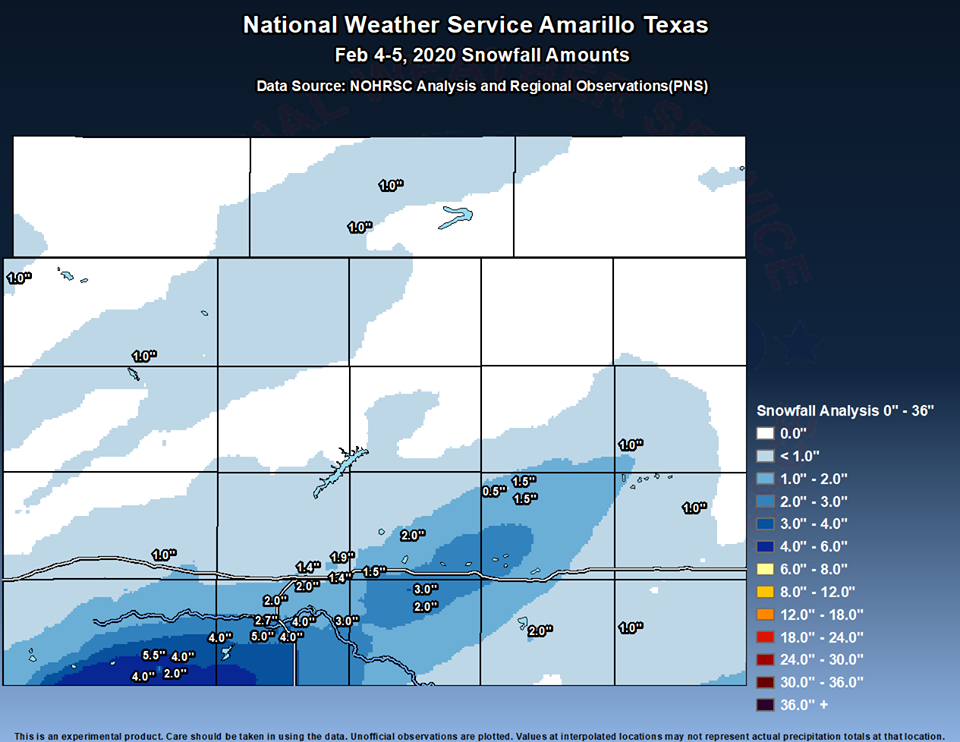
Here's a look at the snowfall totals for the winter event yesterday. Note: These totals are based on observations and satellite blends, with areas that may have received above or below what is shown.
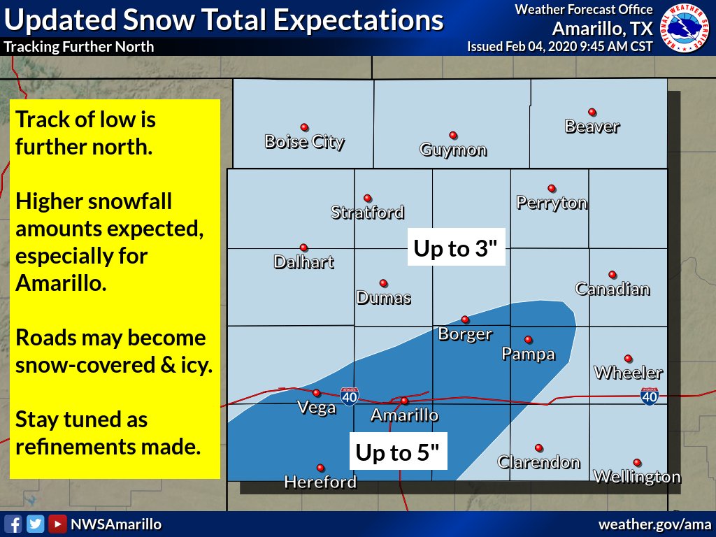
Now here is the update that we came out with at 10 AM on Tuesday as we could see things were setting up to be potentially bad.
Photos
Images.jpg) |
.jpg) |
.jpg) |
.jpg) |
| Claude (Tessa Foster Waddell) |
Canyon heading to Amarillo (Keryn Sippy) |
Shawna Durham Hanks (Lake Tanglewood) |
Hereford (Stefany Powell) |
.jpg) |
.jpg) |
.jpg) |
.jpg) |
| 1:45PM Amarillo (Seán Callahan) |
3:45PM Amarillo (Seán Callahan) |
Canyon (Dulce Flores) |
Clarendon (Brandy Keen) |
.jpg) |
.jpg) |
.jpg) |
.jpg) |
| Canyon (Carolyn Baum) |
Groom & I-40 Westbound (Stephanie Jaquess) |
Amarillo Parking Lot 25 min wait (Angela Hartfelder) |
Palo Duro Canyon (Luigi Meccariello) |
Radar & Satellite
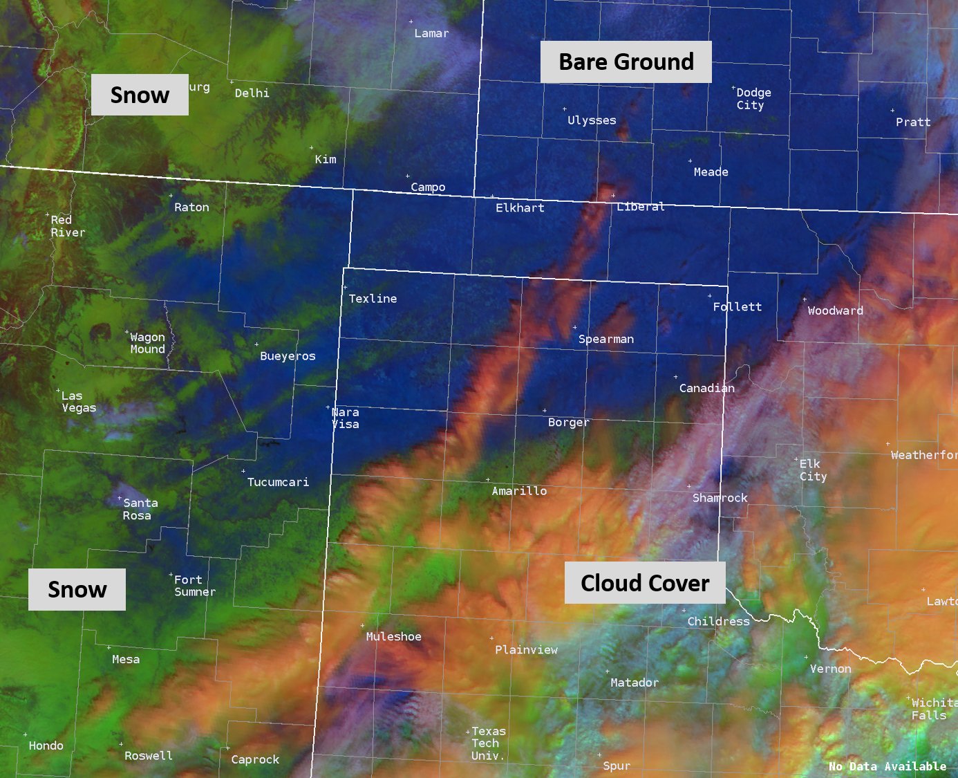 |
| GOES-16 RGB distinguishing between fresh snow on the ground, cloud cover, and bare ground |
| Video of visible satellite showing 60 mile wide snow band from February 4th |
| Video of composite radar during the February 4th, 2020 snow event. Radar data from NWS; image from Iowa Environmental Mesonet |
Storm Reports
..TIME...   ...EVENT...      ...CITY LOCATION...     ...LAT.LON...
..DATE...   ....MAG....      ..COUNTY LOCATION..ST.. ...SOURCE....
            ..REMARKS..

0924 AM     SNOW             DALHART                 36.06N 102.51W
02/04/2020  E1.0 INCH        DALLAM             TX   STORM CHASER

            AN INCH OF GRAINY SNOW REPORTED IN DALHART.

1147 AM     SNOW             TEXLINE                 36.38N 103.02W
02/04/2020  M1.0 INCH        DALLAM             TX   TRAINED SPOTTER

            SNOWED FOR AN HOUR, DROPPED ONE INCH AS SNOWBAND MOVED
            THROUGH.

1149 AM     SNOW             GOODWELL                36.59N 101.63W
02/04/2020  E1.0 INCH        TEXAS              OK   TRAINED SPOTTER

            FAST MOVING SNOWBAND DROPPED AN INCH OF SNOW WITH
            REDUCED VISIBILITY.

1157 AM     SNOW             5 NNW GUYMON            36.76N 101.50W
02/04/2020  E1.0 INCH        TEXAS              OK   PUBLIC

            INCH OF SNOW HAS FALLEN, WITH SNOW ALONG SIDE OF U.S.
            HIGHWAY 64 AND 412. NO ROAD IMPACTS WERE NOTED.

0245 PM     SNOW             HEREFORD                34.82N 102.40W
02/04/2020  M2.0 INCH        DEAF SMITH         TX   TRAINED SPOTTER

            MEASURED AT TIME OF CALL. MODERATE SNOW ONGOING.

0322 PM     SNOW             3 E CANYON              34.98N 101.87W
02/04/2020  M2.0 INCH        RANDALL            TX   NWS EMPLOYEE

            MODERATE SNOW ONGOING AT TIME OF REPORT.

0338 PM     SNOW             VEGA                    35.25N 102.43W
02/04/2020  M1.0 INCH        OLDHAM             TX   TRAINED SPOTTER

            BLOWING SNOW AT TIME OF REPORT WITH 1/2 MILE
            VISIBILITY.

0355 PM     SNOW             HEREFORD                34.82N 102.40W
02/04/2020  M4.0 INCH        DEAF SMITH         TX   TRAINED SPOTTER

            LIGHT SNOW ONGOING, BUT HAS BEEN DECREASING RAPIDLY IN
            PREVIOUS 15 MINUTES.

0400 PM     SNOW             MIAMI                   35.69N 100.64W
02/04/2020  U0.0 INCH        ROBERTS            TX   DEPT OF HIGHWAYS

            LATE REPORT: TEXT DOT REPORTED LOW VISIBILITY DUE TO
            BLOWING SNOW AND DISCOURAGED TRAVEL DUE TO BLACK ICE
            ALONG HWY 60 IN ROBERTS COUNTY.

0406 PM     SNOW             2 N CANYON              35.01N 101.92W
02/04/2020  M2.7 INCH        RANDALL            TX   SOCIAL MEDIA

            MODERATE SNOW ONGOING AT TIME OF REPORT.

0422 PM     SNOW             CLAUDE                  35.11N 101.36W
02/04/2020  E2.0 INCH        ARMSTRONG          TX   TRAINED SPOTTER

            HEAVY SNOW AT TIME OF REPORT. TRUCK JACKKNIFED ON 287
            JUST WEST OF CLAUDE.

0430 PM     SNOW             7 ENE AMARILLO          35.23N 101.71W
02/04/2020  M1.4 INCH        POTTER             TX   OFFICIAL NWS OBS

            MODERATE SNOW AT TIME OF OBSERVATION.

0448 PM     SNOW             1 W AMARILLO            35.20N 101.84W
02/04/2020  M1.4 INCH        POTTER             TX   BROADCAST MEDIA

            KAMR REPORT. LIGHT SNOW ONGOING.

0500 PM     SNOW             6 SSW AMARILLO          35.13N 101.87W
02/04/2020  E2.0 INCH        RANDALL            TX   PUBLIC

            NEAR FARMERS AVE & GEORGIA ST.

0515 PM     SNOW             5 SW AMARILLO           35.15N 101.87W
02/04/2020  M1.5 INCH        RANDALL            TX   NWS EMPLOYEE

0531 PM     SNOW             2 N PALO DURO CANYON    34.98N 101.68W
02/04/2020  M3.0 INCH        RANDALL            TX   BROADCAST MEDIA

            THREE INCHES OF SNOW AT THE RIM OF PALO DURO CANYON.

0533 PM     SNOW             WASHBURN                35.18N 101.57W
02/04/2020  E1.5 INCH        ARMSTRONG          TX   TRAINED SPOTTER

            LIGHT FLURRIES WERE STILL FALLING.

0533 PM     SNOW             CANYON                  34.98N 101.92W
02/04/2020  M5.0 INCH        RANDALL            TX   TRAINED SPOTTER

            SNOW HAD ENDED AT TIME OF REPORT.

0535 PM     SNOW             PAMPA                   35.55N 100.96W
02/04/2020  E1.5 INCH        GRAY               TX   FIRE DEPT/RESCUE

            MODERATE SNOW WAS STILL FALLING AT TIME OF REPORT.

0538 PM     SNOW             2 SW PANHANDLE          35.33N 101.41W
02/04/2020  E2.0 INCH        CARSON             TX   EMERGENCY MNGR

            SNOW WAS STILL FALLING AT TIME OF REPORT.

0541 PM     SNOW             CLARENDON               34.94N 100.89W
02/04/2020  E2.0 INCH        DONLEY             TX   LOCAL OFFICIAL

            SNOW WAS STILL FALLING AT TIME OF REPORT.

0549 PM     SNOW             1 E WHEELER             35.44N 100.26W
02/04/2020  E1.0 INCH        WHEELER            TX   TRAINED SPOTTER

            BLOWING SNOW OCCURING AT TIME OF REPORT.

0557 PM     SNOW             5 WNW TIMBERCREEK CANYO 35.07N 101.90W
02/04/2020  E2.0 INCH        RANDALL            TX   TRAINED SPOTTER

0600 PM     SNOW             7 ENE AMARILLO          35.24N 101.70W
02/04/2020  M1.9 INCH        POTTER             TX   OFFICIAL NWS OBS

0604 PM     SNOW             3 E CANYON              34.98N 101.87W
02/04/2020  M4.0 INCH        RANDALL            TX   NWS EMPLOYEE

0614 PM     SNOW             CANYON                  34.98N 101.92W
02/04/2020  E4.0 INCH        RANDALL            TX   PUBLIC

            NEAR REEVES-HINGER SCHOOL.

0627 PM     SNOW             2 N CANYON              35.01N 101.92W
02/04/2020  M3.3 INCH        RANDALL            TX   TRAINED SPOTTER

            STORM TOTAL SNOW.

0636 PM     SNOW             CLAUDE                  35.11N 101.36W
02/04/2020  E3.0 INCH        ARMSTRONG          TX   TRAINED SPOTTER

            STORM TOTAL SNOW.

0718 PM     SNOW             4 SSW AMARILLO          35.14N 101.86W
02/04/2020  M2.0 INCH        RANDALL            TX   NWS EMPLOYEE

0944 PM     SNOW             4 SE LORA               35.70N 100.52W
02/04/2020  E1.0 INCH        HEMPHILL           TX   TRAINED SPOTTER

0255 AM     SNOW             7 WNW QUAIL             34.95N 100.52W
02/05/2020  E1.0 INCH        COLLINGSWORTH      TX   DEPT OF HIGHWAYS

            SNOW PLOWING IN COLLINGSWORTH COUNTY. NORTHWEST AND
            WEST PART OF THE COUNTY RECEIVED ABOUT AN INCH WHILE THE
            REMAINDER OF THER COUNTY RECEIVED A LIGHT DUSTING OR UP
            TO AN INCH. ROADS ARE PASSABLE AND NOT BAD

0559 AM     SNOW             DAWN                    34.91N 102.20W
02/05/2020  M4.0 INCH        DEAF SMITH         TX   PUBLIC

0630 AM     SNOW             1 N HEREFORD            34.84N 102.40W
02/05/2020  M5.5 INCH        DEAF SMITH         TX   COCORAHS

            COCORAHS STATION TX-DS-5
 |
Media use of NWS Web News Stories is encouraged! Please acknowledge the NWS as the source of any news information accessed from this site. |
|