Overview
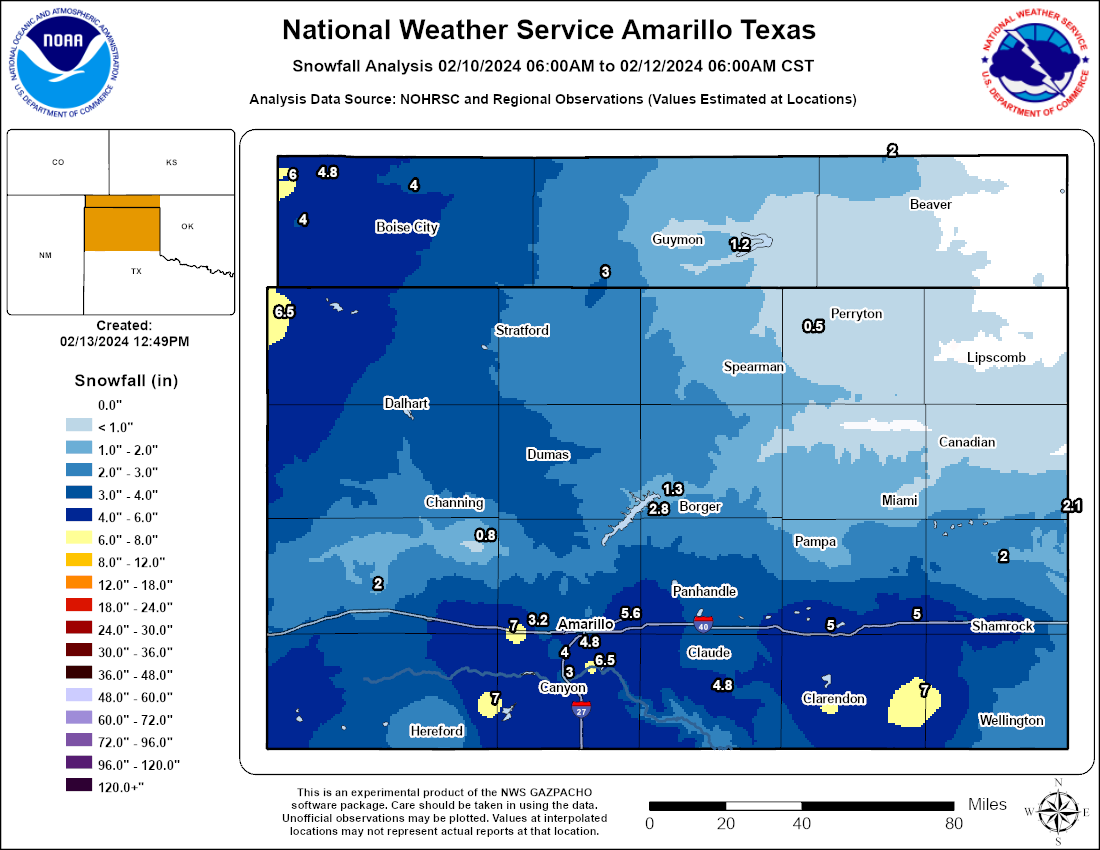
A strong upper level low pressure system moved across the western United States and eventually across southern New Mexico and west Texas during the weekend of February 10-11. Out ahead of this feature, moisture was able to move in across the region which allowed rain and snow showers to develop across the Panhandles by late morning on Saturday. Temperatures for most areas were above freezing, other than the northwest where temperatures were below freezing which allowed for snowfall to begin to accumulate across this area. On Saturday, between 1-3 inches of snow fell across the far northwest in areas like Texline, TX and Cimarron County in Oklahoma. A cold front pushed down late Saturday night into early Sunday morning and cooled temperatures down below freezing for the entire area. Early on Sunday, better lift provided by the low pressure system started to move across the Panhandles and allowed numerous bands of widespread snowfall to develop over the region. Snowfall rates up to a half inch to an inch per hour occurred in the heaviest snow bands. The system exited to the east during the evening on Sunday. Snowfall totals ranged anywhere from a Trace up to 7 inches across the Panhandles. The highest totals were located across the northwest, where 4-6 inches of snowfall was measured from Saturday into Sunday. The other area of higher totals was across the southern Texas Panhandle on Sunday, where snowfall accumulations ranged from 3.5 to 6.5 inches.
Snowfall
Photos & Video
Header
.jpg) |
.jpg) |
.jpg) |
.jpg) |
| Snowy driveway in Amarillo (Beto Castaneda) |
About 1.5 inches of snow measured in Borger (Charles Gillingham) |
Snowy backyard in Shamrock (Dana Kidd) |
Plenty of snow in Shamrock (Glenda Rodgers) |
.jpg) |
.jpg) |
.jpg) |
.jpg) |
| We don't exactly recommend riding a back on a snowy road in Amarillo (Jim Brisket) |
A snow covered Palo Duro Canyon (Matthew Regehr) |
Light drifting in Amarillo (Ronda Smelker) |
4 inches measured in Amarillo (Tricia Kennedy) |
Radar
Header
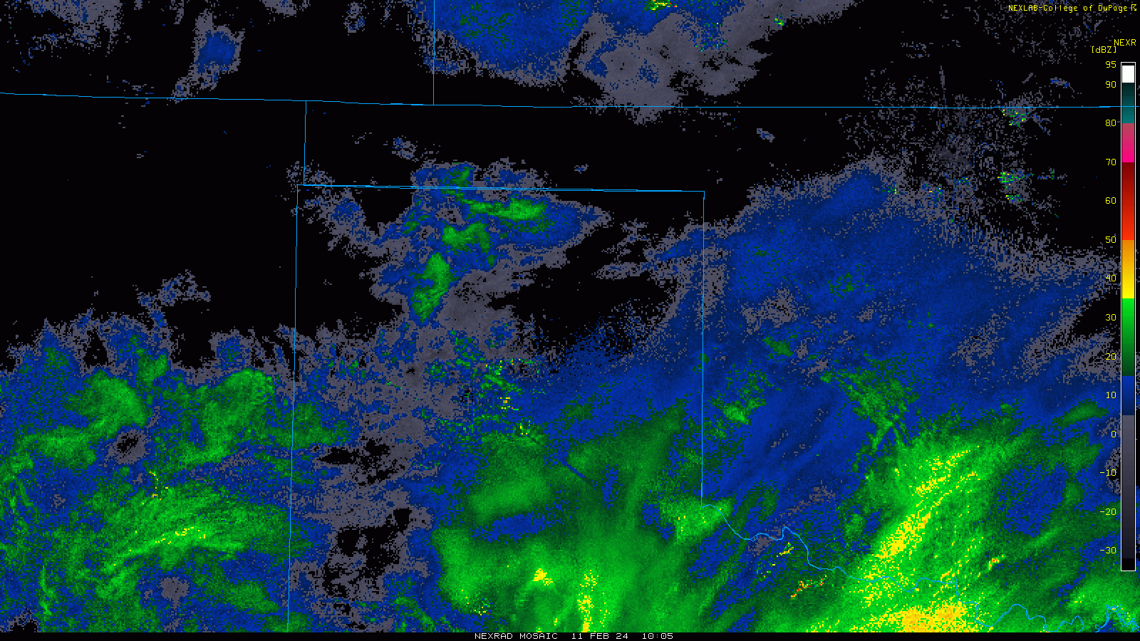 |
| Radar loop showing composite reflectivity through the event. The radar beam mostly overshot what occurred in the northwestern Panhandles, thus the lack of radar returns there. |
Storm Reports
Preliminary Local Storm Report...Summary
National Weather Service Amarillo TX
948 PM CST Sun Feb 11 2024

..TIME...   ...EVENT...      ...CITY LOCATION...     ...LAT.LON...
..DATE...   ....MAG....      ..COUNTY LOCATION..ST.. ...SOURCE....
            ..REMARKS..

0530 AM     Snow             Texline                 36.38N 103.02W
02/11/2024  M6.0 inch        Dallam             TX   Cocorahs


0600 AM     Snow             7 ENE Amarillo          35.23N 101.71W
02/11/2024  M1.3 inch        Potter             TX   Official NWS Obs


0640 AM     Snow             4 W Wheeless            36.72N 102.97W
02/11/2024  M4.0 inch        Cimarron           OK   Cocorahs


0650 AM     Snow             Borger                  35.66N 101.40W
02/11/2024  M0.5 inch        Hutchinson         TX   Emergency Mngr


0651 AM     Snow             3 SE Dalhart            36.03N 102.48W
02/11/2024  M4.0 inch        Hartley            TX   Public


0700 AM     Snow             10.4 WSW Perryton       36.33N 100.98W
02/11/2024  M0.5 inch        Ochiltree          TX   Cocorahs


0700 AM     Snow             2 N Texhoma             36.53N 101.79W
02/11/2024  M3.0 inch        Texas              OK   Public


0700 AM     Snow             Stratford               36.33N 102.07W
02/11/2024  M2.8 inch        Sherman            TX   Public


0745 AM     Snow             4 ENE Bushland          35.20N 102.00W
02/11/2024  M2.1 inch        Potter             TX   Public


0800 AM     Snow             1 NNE Black Mesa Park   36.87N 102.87W
02/11/2024  M4.5 inch        Cimarron           OK   Cocorahs


1055 AM     Snow             5 W Amarillo            35.19N 101.90W
02/11/2024  M3.0 inch        Potter             TX   Trained Spotter

            3 inches of snow measured at I-40 and Bell,
            with drifts of 8-10 inches.

1115 AM     Snow             3 SSW Amarillo          35.16N 101.84W
02/11/2024  M3.5 inch        Randall            TX   Public


1120 AM     Snow             9 N Boise City          36.86N 102.51W
02/11/2024  E4.0 inch        Cimarron           OK   Emergency Mngr

            HWY 287 will be closed from Boise City, OK
            to Campo, CO due to ice, snow cover, and
            several accidents. Many other roads/highways
            in Cimarron county are slick as well. Light
            snow still falling at time of report.

1200 PM     Snow             2 S Greenbelt Lake      34.98N 100.92W
02/11/2024  E3.5 inch        Donley             TX   Public

            Social Media report noted 3.5 inches of snow
            southwest of Greenbelt Lake.

1200 PM     Snow             7 ENE Amarillo          35.23N 101.71W
02/11/2024  M3.6 inch        Potter             TX   Official NWS Obs

            Still snowing.

1230 PM     Snow             6 NNW Amarillo          35.29N 101.85W
02/11/2024  M2.5 inch        Potter             TX   Broadcast Media


0200 PM     Snow             Guymon                  36.68N 101.48W
02/11/2024  E1.0 inch        Texas              OK   Law Enforcement

            Storm total. Snow has almost all melted.

0200 PM     Snow             5 SW Amarillo           35.15N 101.87W
02/11/2024  M3.7 inch        Randall            TX   Trained Spotter


0218 PM     Snow             5 WSW Amarillo          35.17N 101.90W
02/11/2024  M4.0 inch        Randall            TX   Public

            Picture from social media indicated 4 inches
            of snow had fallen.

0230 PM     Snow             7 SW Amarillo           35.13N 101.91W
02/11/2024  M3.0 inch        Randall            TX   Trained Spotter

            Still snowing.

0236 PM     Snow             Kenton                  36.90N 102.97W
02/11/2024  M6.0 inch        Cimarron           OK   Public

            Social media had two comments from two
            different people reporting 6 inches of snow
            in Kenton.

0246 PM     Snow             Timbercreek Canyon      35.06N 101.81W
02/11/2024  M6.5 inch        Randall            TX   Public

            6.5 inches measured near Timbercreek Canyon
            and Palisades.

0325 PM     Snow             Mclean                  35.23N 100.60W
02/11/2024  M5.0 inch        Gray               TX   Public

            Public report of 5.0 inches in McLean via
            social media. Snow still ongoing at time of
            report.

0339 PM     Snow             3 N Timbercreek Canyon  35.09N 101.81W
02/11/2024  M6.0 inch        Randall            TX   Public

            Still snowing.

0343 PM     Snow             4 SSW Amarillo          35.15N 101.84W
02/11/2024  M5.4 inch        Randall            TX   Trained Spotter

            Still snowing.

0345 PM     Snow             4 SW Amarillo           35.16N 101.87W
02/11/2024  M4.8 inch        Randall            TX   Public

            Social media post with a tape measure.

0400 PM     Snow             Clarendon               34.94N 100.89W
02/11/2024  E4.0 inch        Donley             TX   Law Enforcement

            Still snowing.

0402 PM     Snow             7 WSW Amarillo          35.15N 101.92W
02/11/2024  M4.0 inch        Randall            TX   Trained Spotter


0459 PM     Snow             2 WSW Amarillo          35.19N 101.86W
02/11/2024  M3.9 inch        Potter             TX   Public

            Storm total.

0529 PM     Snow             6 WSW Amarillo          35.17N 101.93W
02/11/2024  M4.0 inch        Randall            TX   Trained Spotter

            Storm total.

0540 PM     Snow             1 SSW Canadian          35.90N 100.39W
02/11/2024  E0.6 inch        Hemphill           TX   Trained Spotter

            Storm total snow. Snow has melted.

0544 PM     Snow             Wheeler                 35.45N 100.27W
02/11/2024  E2.0 inch        Wheeler            TX   Law Enforcement

            Storm total snow.

0550 PM     Snow             1 SSE Shamrock          35.21N 100.24W
02/11/2024  M4.6 inch        Wheeler            TX   Trained Spotter

            Still snowing.

0557 PM     Snow             1 SSE Wellington        34.85N 100.21W
02/11/2024  E2.5 inch        Collingsworth      TX   Trained Spotter

            Still snowing lightly.

0602 PM     Snow             1 WNW Claude            35.11N 101.37W
02/11/2024  E3.5 inch        Armstrong          TX   Public

            3 to 4 inches of snow. Storm total. Light
            snow off and on now.

0637 PM     Snow             7 ENE Amarillo          35.23N 101.71W
02/11/2024  M5.6 inch        Potter             TX   Official NWS Obs

            Storm total snow.

0639 PM     Snow             Canyon                  34.98N 101.93W
02/11/2024  M6.0 inch        Randall            TX   Trained Spotter

            Storm total snow.

0640 PM     Snow             Clarendon               34.93N 100.89W
02/11/2024  E6.0 inch        Donley             TX   Public


0642 PM     Snow             2 N Canyon              35.01N 101.92W
02/11/2024  M3.0 inch        Randall            TX   Trained Spotter

            Storm total snow.

0654 PM     Snow             8 ESE Bushland          35.13N 101.94W
02/11/2024  M3.5 inch        Randall            TX   Trained Spotter

            Storm total snow.

0703 PM     Snow/Ice Dmg     Groom                   35.20N 101.11W
02/11/2024                   Carson             TX   Law Enforcement

            Several accidents reported along Interstate
            40 in southern Gray County.

0703 PM     Snow             1 S Pampa               35.54N 100.96W
02/11/2024  E1.5 inch        Gray               TX   Law Enforcement

            1 to maybe 2 inches. Storm total snow.

0736 PM     Snow             Hereford                34.82N 102.41W
02/11/2024  E1.5 inch        Deaf Smith         TX   Law Enforcement

            1 to 2 inches of snow. Storm total snow.

0758 PM     Snow             10 S Claude             34.96N 101.36W
02/11/2024  M4.8 inch        Armstrong          TX   Trained Spotter

            Storm total snow. 20 inch drifts.

0918 PM     Snow             Miami                   35.69N 100.64W
02/11/2024  M0.5 inch        Roberts            TX   Broadcast Media

            Storm total snow.


&&

$$
Environment
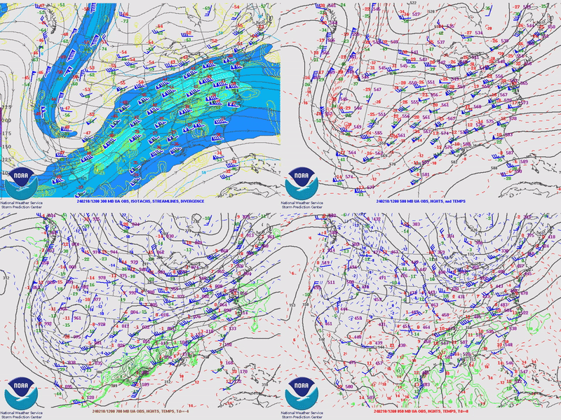 |
| Four panel look at 300/500/700/850mb analyses during the February 10th and 11th snow event. A deep large scale trough advanced eastward over the Panhandles, providing sufficient lift for snow to occur. |
 |
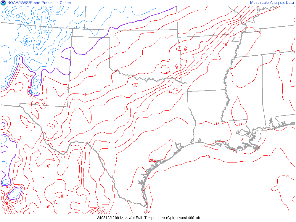 |
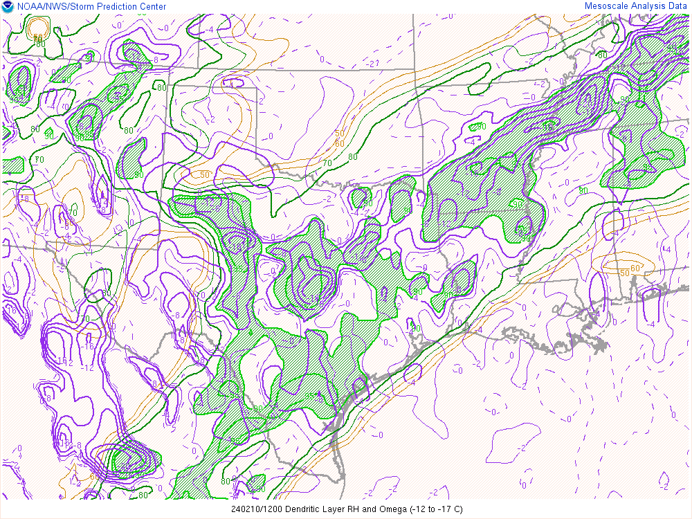
| Lift and moisture within the dendritic growth zone, the most favorable temperatures aloft for snow generation. When the dendritic growth zone is both saturated and experiencing strong lift, large snowflakes known as dendrites are generated and then fall to the ground. Both the northwestern Panhandles and southern Texas Panhandle had an extended period with favorable conditions for large snowflake development. | After those large flakes are generated higher up in the atmosphere, they have to fall to the ground without melting. This shows the warmest wet bulb temperature in the lower part of the atmosphere. When this is below zero, snowflakes will usually survive the fall without melting. This was below zero through the vast majority of the event. |
 |
Media use of NWS Web News Stories is encouraged! Please acknowledge the NWS as the source of any news information accessed from this site. |
|

