
Widespread life-threatening flash and urban flooding continues in south-central Texas, with considerable flooding impacts possible across central Texas. Wildfire smoke is impacting air quality across much of the Great Lakes region into southern New England and the Mid-Atlantic. Monsoonal thunderstorms may produce isolated to scattered flash flooding across the Southwest into the Great Basin. Read More >
Overview
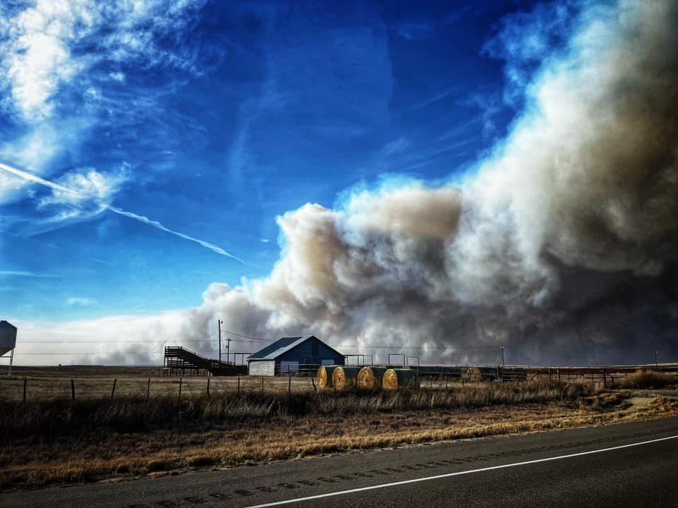
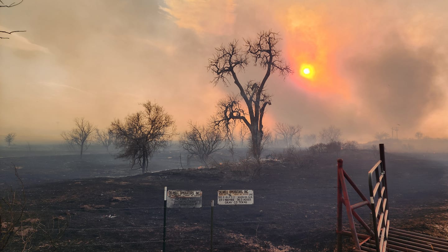
A good growing season through spring and summer of 2023 led to decent grass fuel loading compared to the previous couple of years before vegetation went into winter dormancy. Dormant fuels and two weeks without precipitation leading into February 26th provided a very combustible environment when combined with abnormally warm temperatures (record breaking) and high winds on Monday, February 26th. An upper level system first brought strong winds on Monday with sustained winds peaking between 25 and 39 mph out of the west. Wind gusts peaked around 55 mph with some locations briefly gusting up to 58 to 62 mph. Not only were the winds strong but relative humidity values also dropped to 12 to 18 percent. These conditions, combined with the dormant and dry state of vegetation, contributed to the development of large wildfires on the 26th. In addition to the weather conditions, rough terrain and limited accessibility contributed to challenges in firefighting efforts. The wildfires continued through the night aided by minimal recovery in relative humidity and only a short lived reduction in winds.
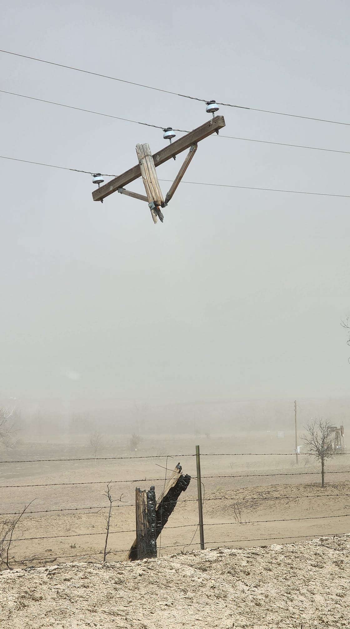
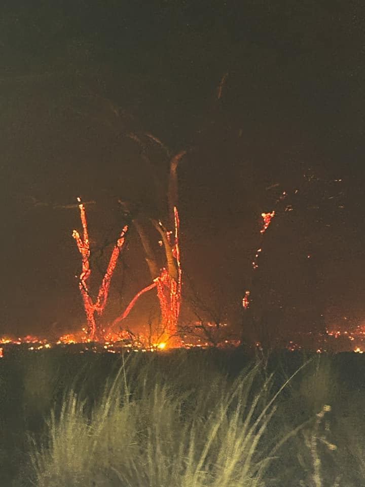
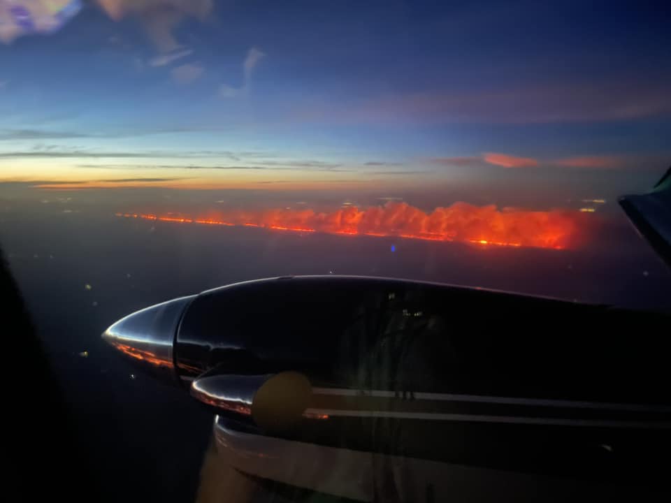
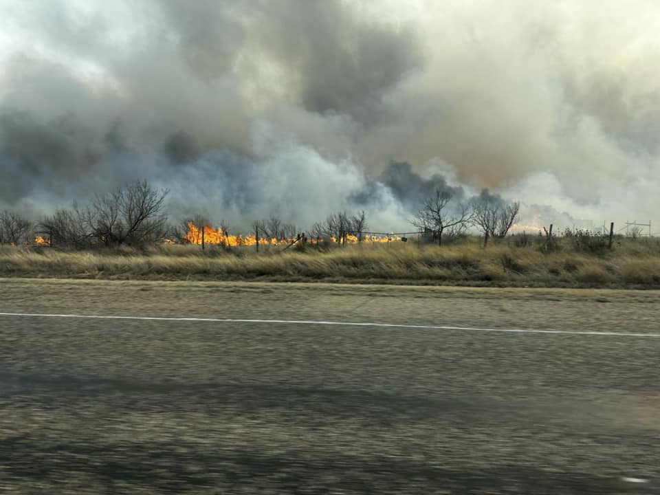
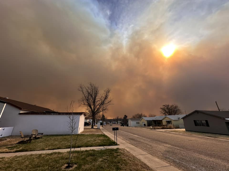
On the morning of the 27th, west to southwest winds quickly picked back up into the 25 to 35 mph range and gusts quickly exceeded 58 mph by the late morning hours. Frequent gusts increased to 65 to 70 mph during the afternoon hours and some areas experienced sustained winds in the 40 to 45 mph range for a few hours as well. With overnight low temperatures only in the 50s, afternoon temperatures rebounded rapidly into the 70s. Despite afternoon temperatures a few degrees cooler than the previous day (the 26th), relative humidity values fell into the 12 to 15 percent range. This prompted rapid growth of ongoing fires and contributed to initiation and growth of a few new fires across the combined Panhandles, some of which merged leading to megafires. The same system contributing to the high winds also pushed a cold front into the area from the north. Fires that once were moving from west to east soon started to move from north to south behind the front. Winds behind the front continued to blow in the 25 to 35 mph range and gusting 40 to 50 mph. Communities that were initially on the right flank of the fire, out of harm's way, soon found themselves on the forward flank that was around 100 miles long.
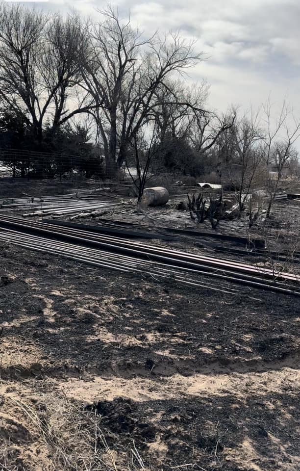
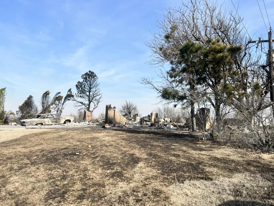
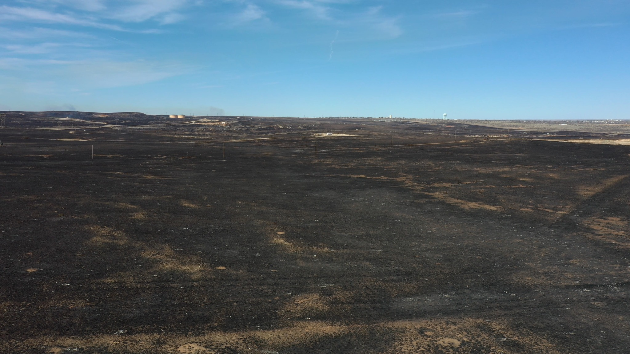
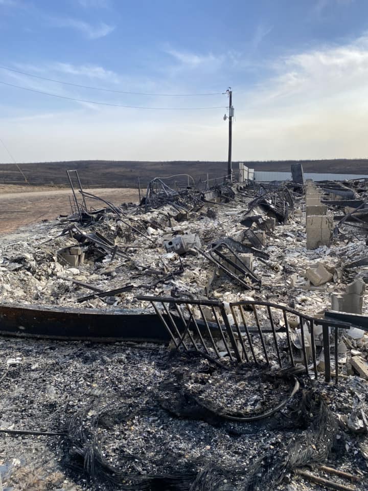
There were roughly 9 named wildfires with some of these merging into one. The 687 Reamer Fire which started on the 27th, the day after the Smokehouse Creek Fire started but it eventually burned into and merged with the Smokehouse Creek Fire. The two largest fires, the Windy Deuce Fire (~144,045 acres burned) and the Smokehouse Creek Fire (~1,058,482 acres burned), were finally 100% contained on March 16, 2024. It is estimated that 2,075 homes were directly impacted by the fire and within the fire perimeter. How many of these housing units are a complete loss is unknown at this time. The fires also left residents without electricity or gas for several days after the 27th of February. Many cattle and livestock were also lost. It is estimated that just over 4,000 lives will forever be changed by these fires. Also, there were two souls lost in the fires on the 27th.
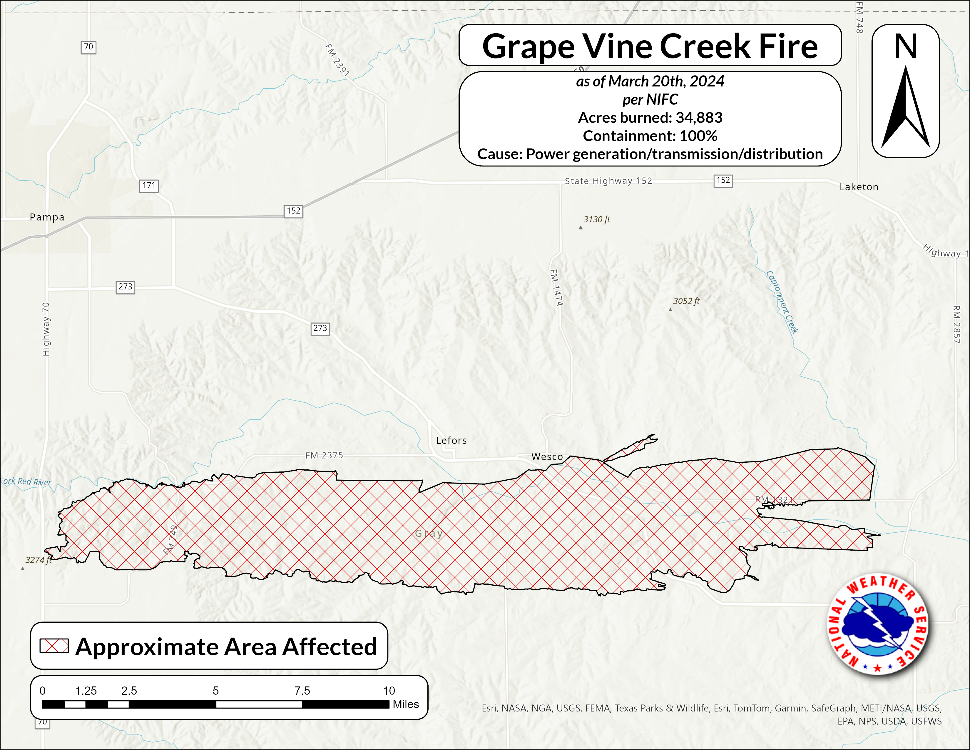 |
| Map of the Grape Vine Creek Fire as of March 20th, 2024 |
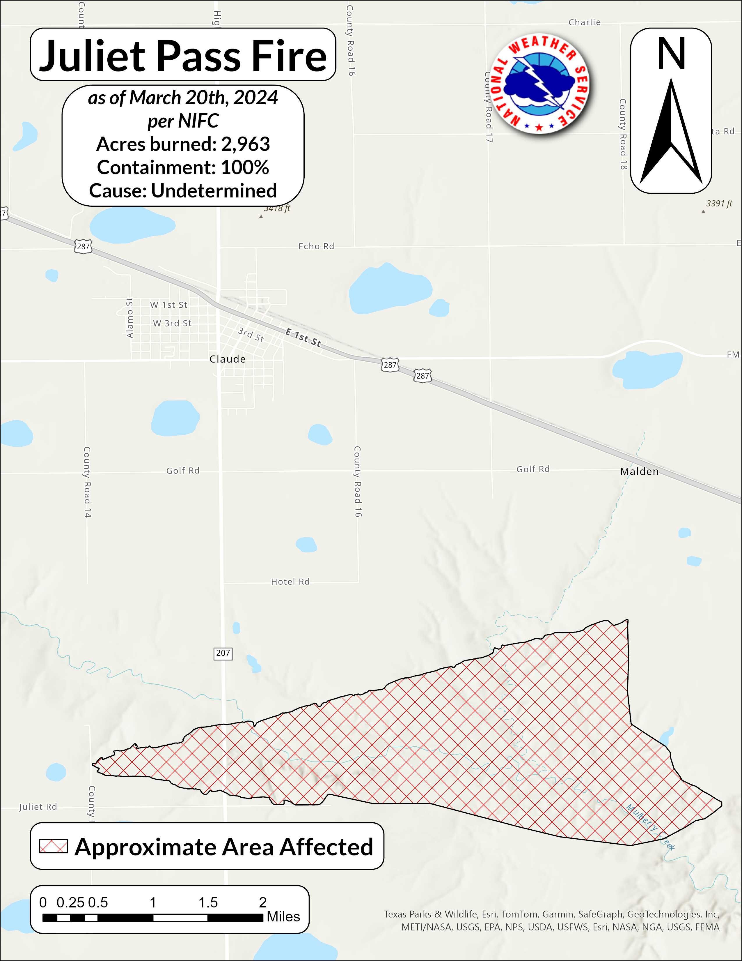 |
| Map of the Juliet Pass Fire as of March 20th, 2024 |
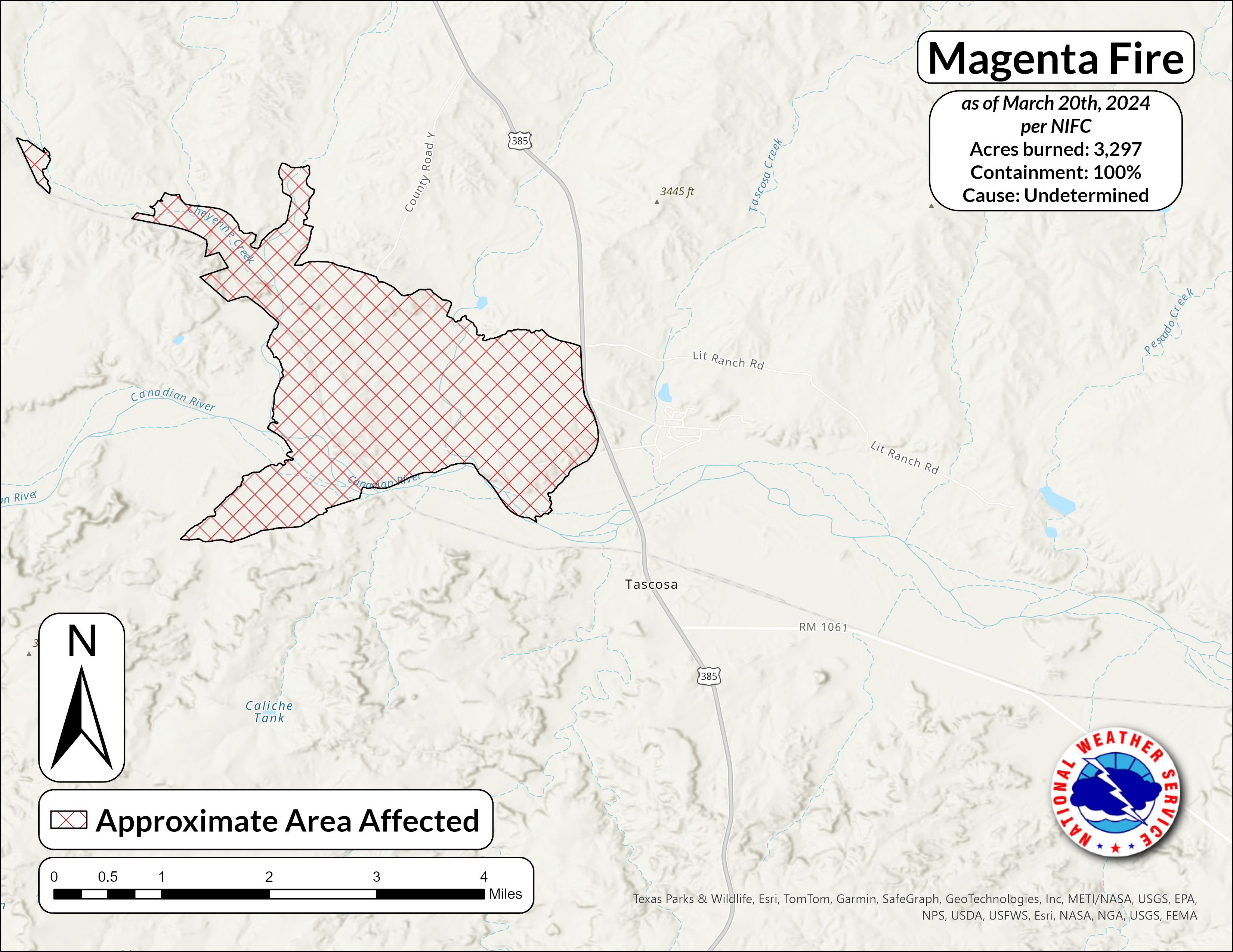 |
| Map of the Magenta Fire as of March 20th, 2024 |
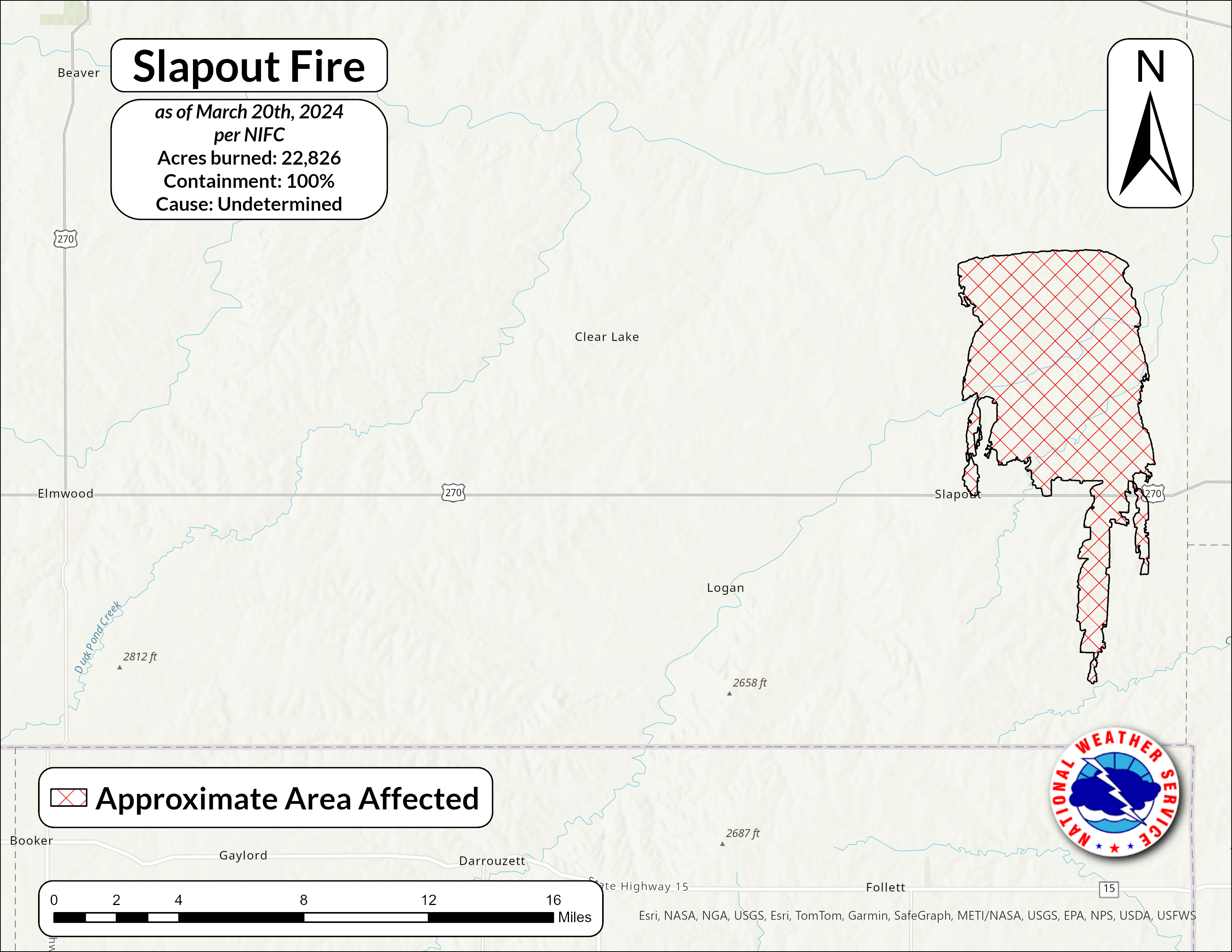 |
| Map of the Slapout Fire as of March 20th, 2024 |
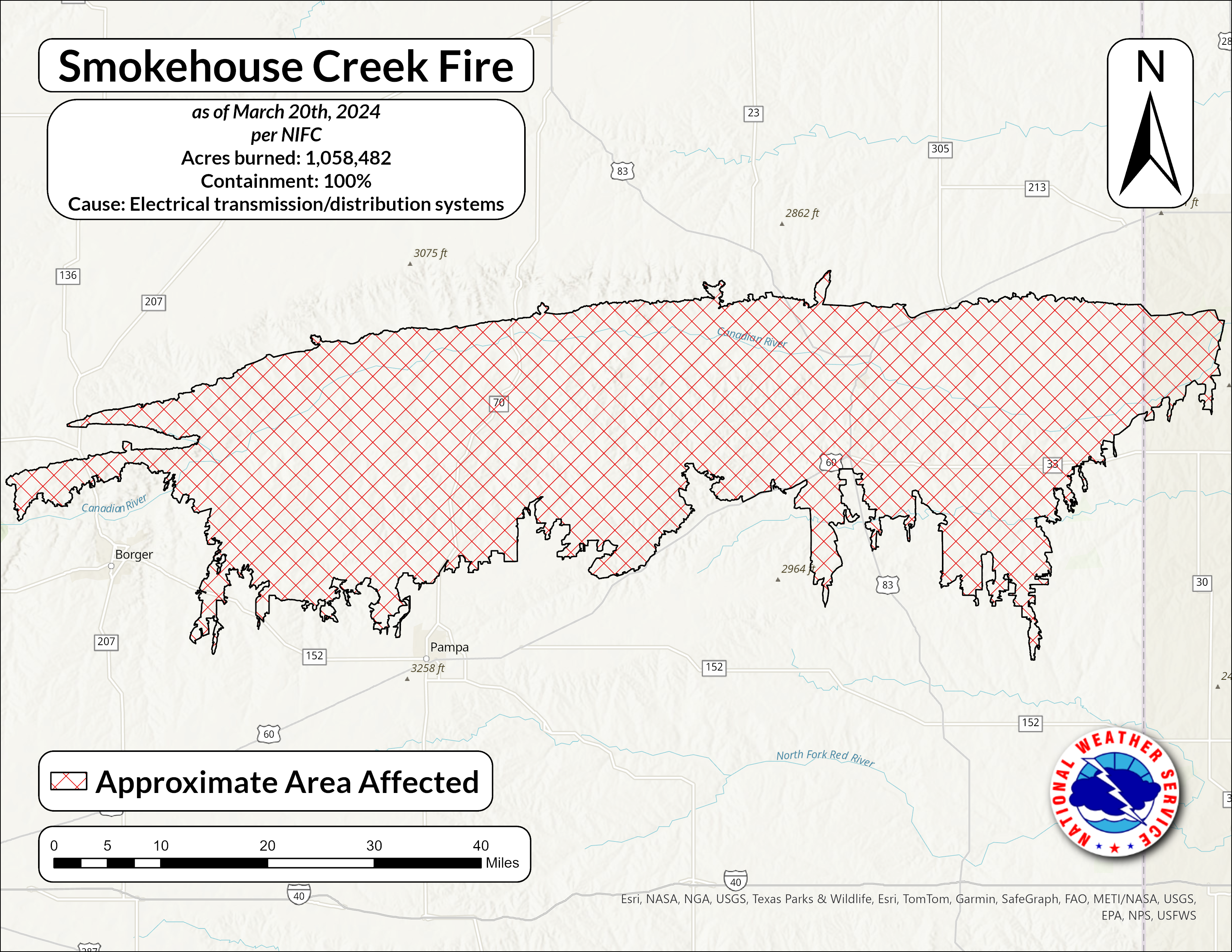 |
| Map of the Smokehouse Creek Fire as of March 20th, 2024 |
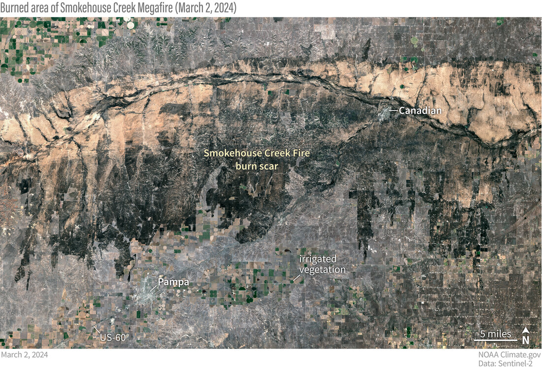 |
| Satellite image of the Smokehouse Creek Fire burn scar as seen by the Sentinel satellite |
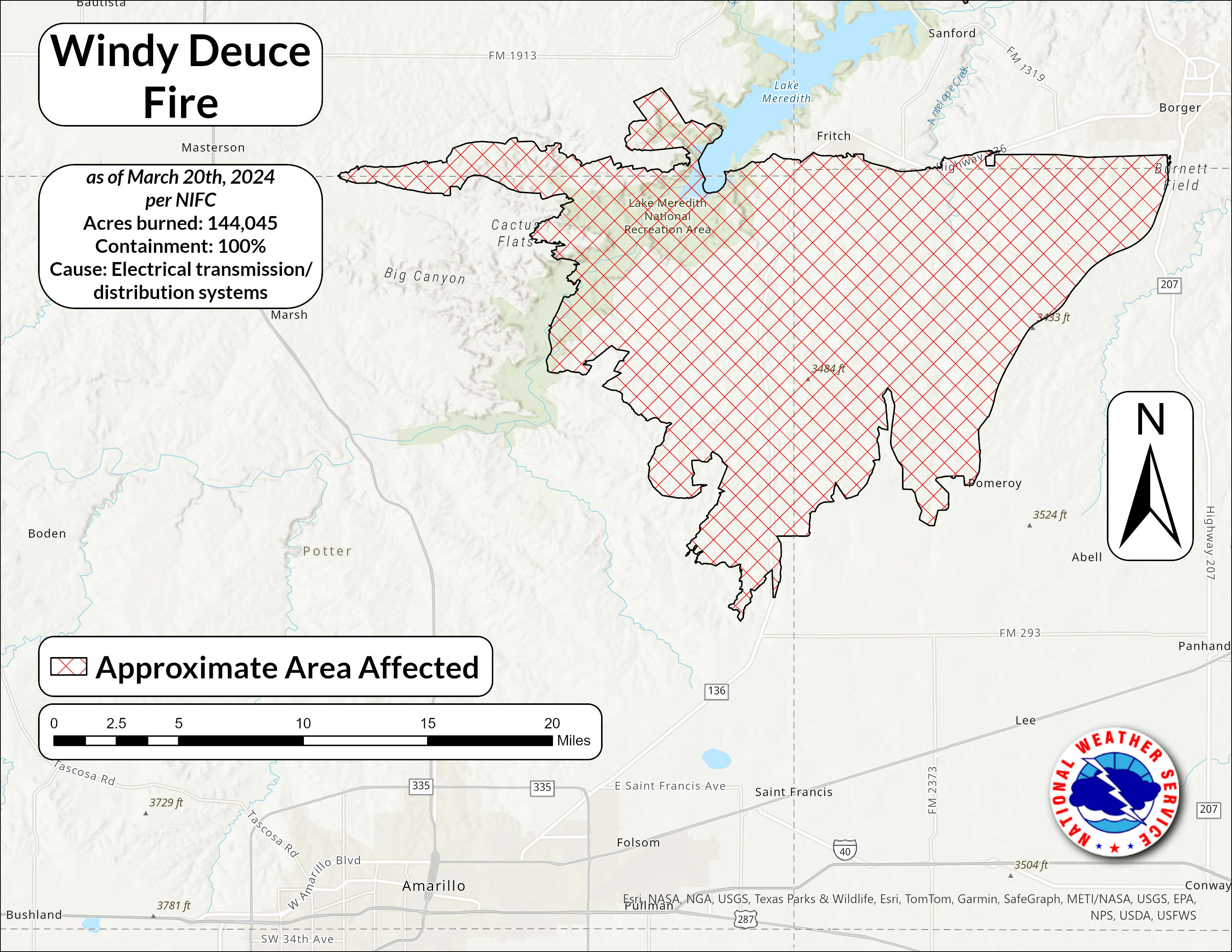 |
| Map of the Windy Deuce Fire as of March 20th, 2024 |
Photos & Video
 |
 |
 |
 |
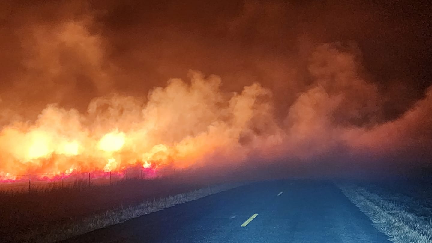
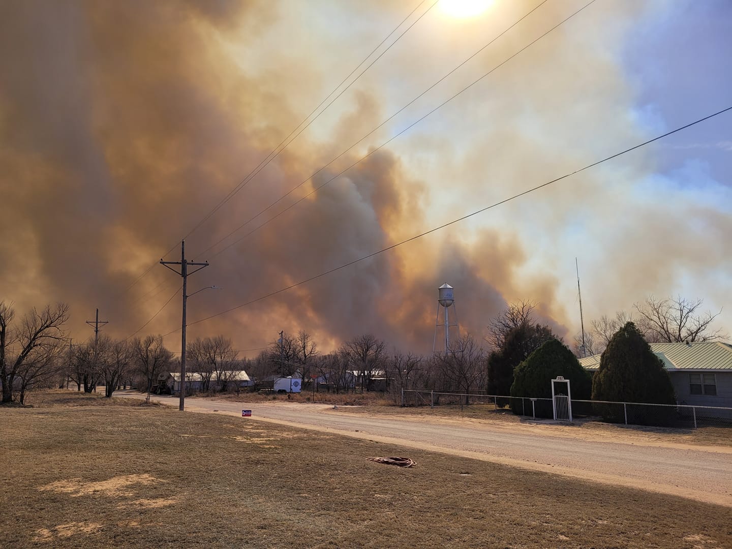
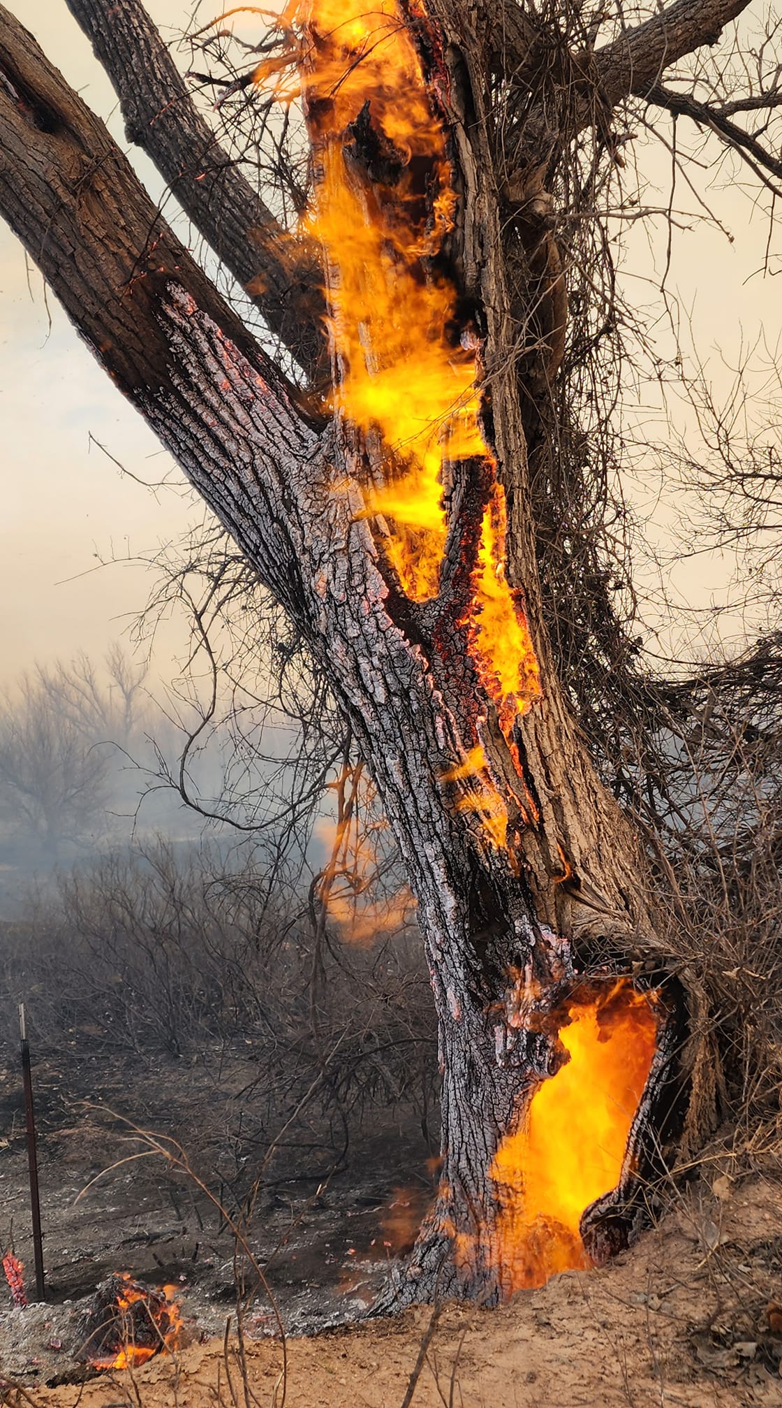
| NE of Pampa, TX (Jason Boggs) |
Lefors, TX (Emily Sprouse) |
Hemphill County Airport (Anna Scholl) |
SSW of Lefors, TX (Jason Boggs) |
 |
 |
 |
 |
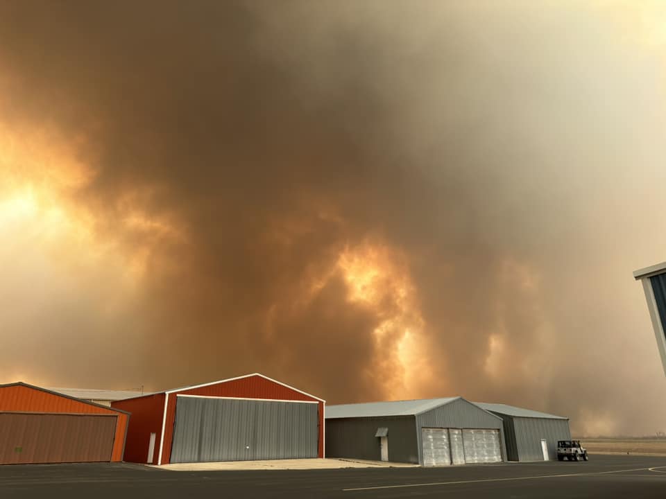
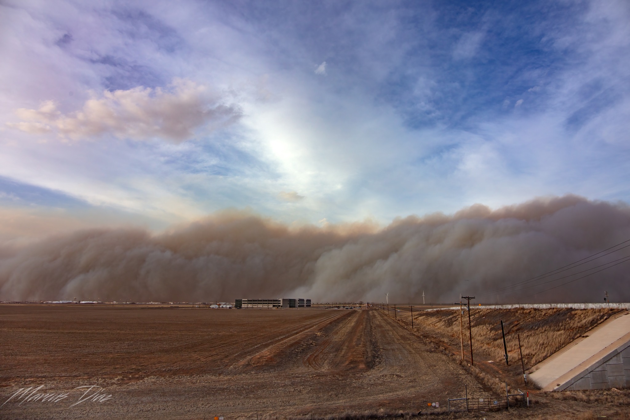
| Pantex (Marcus Diaz) |
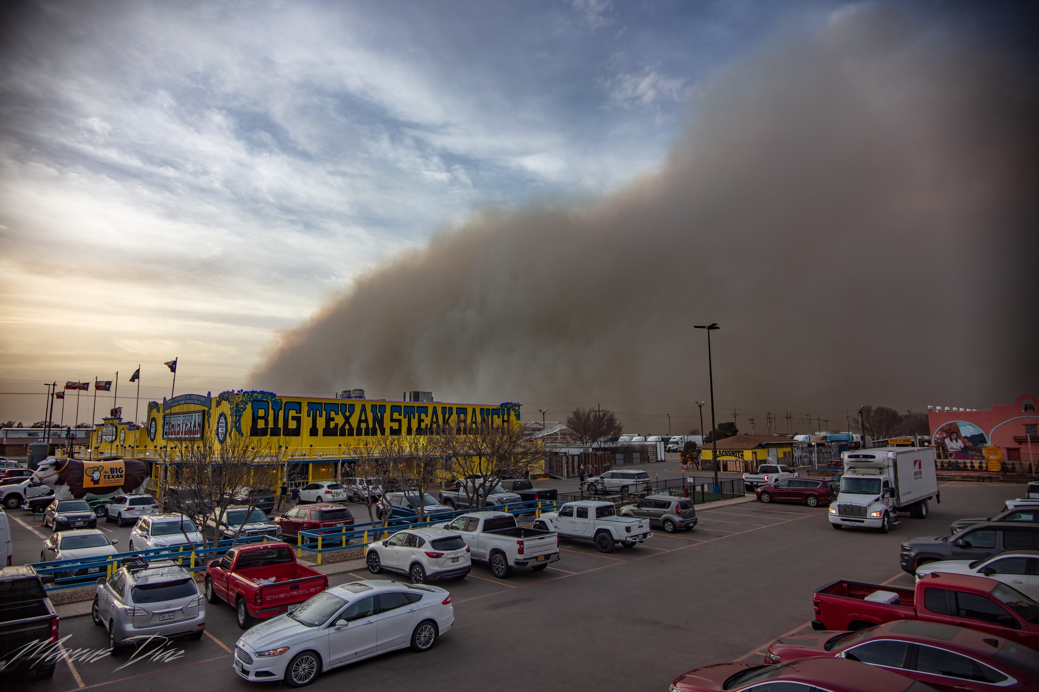
Big Texan (Marcus Diaz) |
Skellytown, TX (Armando Ortiz) |
S of Skellytown, TX (Kala Griffith) |
 |
 |
 |
 |
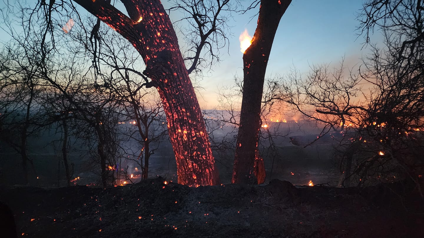
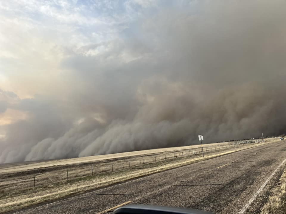
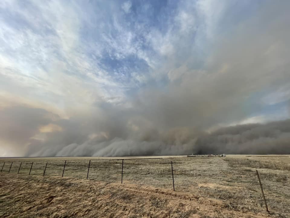
| SSW of Lefors, TX (Jason Boggs) |
S of Lefors, TX (Jason Boggs) |
Mansfield Ranch (Ross Montgomery) |
Stinnett, TX (Zenith Heddins) |
 |
 |
 |
 |
| E of Pampa, TX (TIm Schlabs) |
N of Pampa, TX (Laura Brandt) |
Canadian, TX (Cherakee Wilson) |
W of Borger, TX (Mary Hodges) |
 |
 |
 |
 |
| S of Borger, TX (Andrew Wilhelm) |
SSW of Lefors, TX (Jason Boggs) |
Canadian, TX (Kelsey Banuelos) |
Borger, TX (Jennifer Barnett) |
Radar
|
Shortwave infrared satellite imagery from February 26th and 27th. Black indicates very hot temperatures - over 100 degrees celsius! - and are thus inferred to be the wildfires. Initial spread of the fires is west to east with the strong winds allowing a long axis of fire to develop. When the cold front arrives on the evening of the 27th, these long axes become a fire front 100 miles long, leading to large scale fire spread. Imagery collected by NOAA/NASA GOES-16. Visualization by College of DuPage NEXLAB. |
|
Two different radar products we can use together to identify smoke plumes as seen on February 27th, 2024 when the cold front reached the fires. Left panel is radar reflectivity - how much power is being bounced back to the radar. Right panel is correlation coefficient - how much velocity measurements vary between the horizontally and vertically polarized pulses the radar sends out. The left panel shows us that something is indeed in the air; in most cases these returns occur due to raindrops, ice crystals, or hail. But, correlation coefficient is usually closer to 1 for raindrops, ice crystals, or hail, while a correlation coefficient near zero suggests the radar pulses are detecting something non-meteorological, in this case smoke particles. The smoke was carried southwestward through Pampa, Amarillo, Hereford, and Canyon, causing reductions in visibility and poor air quality. Please note the radar changed operating modes midway through the loop, thus the spatial reduction in radar returns. |
Storm Reports
Preliminary Local Storm Report...Summary
National Weather Service Amarillo TX
341 AM CST Thu Feb 29 2024

..TIME...   ...EVENT...      ...CITY LOCATION...     ...LAT.LON...
..DATE...   ....MAG....      ..COUNTY LOCATION..ST.. ...SOURCE....
            ..REMARKS..

1030 AM     Non-Tstm Wnd Gst 1 S Black Mesa Park     36.83N 102.88W
02/27/2024  M59 MPH          Cimarron           OK   Mesonet

            First 58 mph or greater gust at 1030 AM.
            Peak gust at 1030 AM. Last gust at 220 PM.

1032 AM     Non-Tstm Wnd Gst 8 W Lipscomb            36.22N 100.41W
02/27/2024  M68 MPH          Lipscomb           TX   Mesonet

            First wind gust exceeding 58 mph occurred at
            1032CST. The peak gust of 68 mph occurred at
            1125CST. Most recent wind gust of 59 mph was
            at 1446CST.

1049 AM     Non-Tstm Wnd Gst 2 WNW Fritch            35.65N 101.62W
02/27/2024  M68 MPH          Moore              TX   Mesonet

            First wind gust exceeding 58 mph occurred at
            1049CST. Peak gust of 68 mph occurred at
            1051CST. Most recent and possibly ending 58
            mph plus wind gust occurred at 1328CST.

1052 AM     Non-Tstm Wnd Gst 3 SE Dumas              35.83N 101.92W
02/27/2024  M70 MPH          Moore              TX   Mesonet

            First gust exceeding 58 mph occurred at
            1052CST. Peak gust of 70 mph occurred at
            1119CST. So far last gust exceeding 58 mph
            was at 1443CST. Sustained winds have
            exceeded 40 mph during these early afternoon
            hours.

1053 AM     Non-Tstm Wnd Gst 3 SW Dalhart            36.02N 102.55W
02/27/2024  M68 MPH          Hartley            TX   ASOS

            Corrects previous tstm wnd gst report from 3
            SW Dalhart. Corrected for event type. First
            58 mph or greater gust at 1053 AM. Peak gust
            at 1111 AM. Last gust at 1210 PM.

1059 AM     Non-Tstm Wnd Gst 4 E Vega                35.24N 102.35W
02/27/2024  M63 MPH          Oldham             TX   Mesonet

            First wind gust of 58 mph plus was at
            1059CST. The peak gust of 63 mph occurred at
            1534CST. The most recent and most likely
            final wind gust over 58 was at 1556CST.

1104 AM     Non-Tstm Wnd Gst 10 ESE Valley de Oro    35.42N 101.93W
02/27/2024  M62 MPH          Potter             TX   Mesonet

            First wing gust exceeding 58 mph occurred at
            1104CST. The peak gust of 62 mph occurred at
            1350CST and was the last thus far.

1115 AM     Non-Tstm Wnd Gst 5 NNW Pampa             35.61N 101.00W
02/27/2024  M61 MPH          Gray               TX   AWOS

            First 58 mph or greater gust at 1115 AM.
            Peak gust at 235 PM. Final gust at 255 PM.

1115 AM     Non-Tstm Wnd Gst 1 WSW Guymon            36.68N 101.51W
02/27/2024  M68 MPH          Texas              OK   ASOS

            Corrects previous tstm wnd gst report from 1
            WSW Guymon. Corrected for event type. First
            58 mph or greater gust at 1115 AM. Peak gust
            at 212 PM. Final gust at 216 PM.

1118 AM     Non-Tstm Wnd Gst 6 ESE Lora              35.71N 100.46W
02/27/2024  M70 MPH          Hemphill           TX   Mesonet

            First gust exceeding 58 mph was at 1118CST.
            Peak gust of 70 mph occurred at 1306CST.
            Last gust so far at 1340CST.

1130 AM     Non-Tstm Wnd Gst 2 N Borger              35.70N 101.39W
02/27/2024  M64 MPH          Hutchinson         TX   ASOS

            Corrects previous tstm wnd gst report from 2
            N Borger. Corrected for event type. First 58
            mph or greater gust at 11:30 AM. Peak gust
            of 64 mph at 12:48 PM. Last gust so far at
            2:51 PM.

1134 AM     Non-Tstm Wnd Gst 4 SSW Pantex            35.28N 101.62W
02/27/2024  M60 MPH          Carson             TX   Mesonet

            First gust of 58 mph plus occurred at
            1134CST. The peak gust of 60 mph occurred at
            1138CST. The most recent and likely last
            gust of 58 to 59 mph was at 1425CST.

1134 AM     Non-Tstm Wnd Gst 2 N Stinnett            35.84N 101.45W
02/27/2024  M65 MPH          Hutchinson         TX   Mesonet

            First gust exceeding 58 mph was at 1134CST.
            The peak gust of 65 mph occurred at 1138CST.
            Most recent and possibly last gust over 58
            occurred at 1416CST.

1149 AM     Non-Tstm Wnd Gst 1 ENE Mclean            35.24N 100.57W
02/27/2024  M59 MPH          Gray               TX   Mesonet

            First gust of 58 mph was at 1149CST with
            another at 1201CST. The peak and last gust
            of 59 mph was at 1307CST.

1200 PM     Non-Tstm Wnd Gst 2 WNW Lake Mcclellan    35.23N 100.90W
02/27/2024  M64 MPH          Gray               TX   Mesonet

            First wind gust over 58 mph was at 1200CST.
            Peak wind gust of 64 mph was at 1216CST.
            Most recent and possibly last wind gust over
            58 was at 1441CST.

1210 PM     Non-Tstm Wnd Gst 1 SSW Beaver            36.80N 100.53W
02/27/2024  M62 MPH          Beaver             OK   Mesonet


1215 PM     Non-Tstm Wnd Gst 3 W Dumas               35.86N 102.01W
02/27/2024  M60 MPH          Moore              TX   AWOS

            Corrects previous tstm wnd gst report from 3
            W Dumas. Corrected for event type.

1220 PM     Non-Tstm Wnd Gst 3 SE Pantex             35.30N 101.54W
02/27/2024  M59 MPH          Carson             TX   Mesonet

            One gust of 59 mph occurred at 1220CST and
            another gust of 58 mph occurred at 1441CST.

1223 PM     Non-Tstm Wnd Gst 9 NW Waka               36.36N 101.18W
02/27/2024  M58 MPH          Hansford           TX   Mesonet


1224 PM     Non-Tstm Wnd Gst 3 W Dozier              35.08N 100.39W
02/27/2024  M58 MPH          Collingsworth      TX   Mesonet


1225 PM     Non-Tstm Wnd Gst 11 S Romero             35.57N 102.96W
02/27/2024  M59 MPH          Oldham             TX   Mesonet


1228 PM     Non-Tstm Wnd Gst 2 WNW Hereford          34.83N 102.42W
02/27/2024  M60 MPH          Deaf Smith         TX   Mesonet

            First wind gust exceeding 58 mph occurred at
            1228CST. The peak gust of 60 mph occurred at
            1233CST. Last gust of 58 or greater occurred
            at 1439CST.

1236 PM     Non-Tstm Wnd Gst 7 E Borger              35.67N 101.28W
02/27/2024  M62 MPH          Hutchinson         TX   Mesonet

            First gust of 58 mph or more occurred at
            1236CST. The peak gust of 62 mph occurred at
            1257CST. Final gust reaching 58 was at
            1350CST.

1244 PM     Non-Tstm Wnd Gst 3 NNE Umbarger          34.99N 102.08W
02/27/2024  M59 MPH          Randall            TX   Mesonet

            The Umbarger mesonet measured a couple of 58
            mph gusts and a couple of 59 mph gusts. The
            first one occurred at 1112CST and the last
            one was at 1334CST.

1253 PM     Non-Tstm Wnd Gst 11 WNW Bootleg          34.89N 102.99W
02/27/2024  M63 MPH          Deaf Smith         TX   Mesonet

            First wind gust over 58 mph was at 1253CST.
            The peak wind gust of 62 mph occurred at
            1317CST. The last wind gust over 58 was at
            1328CST.

0100 PM     Non-Tstm Wnd Gst 6 E Amarillo            35.22N 101.72W
02/27/2024  M62 MPH          Potter             TX   ASOS

            Several wind gusts of 58 to 62 mph were
            measured by the ASOS at the Amarillo Airport
            between 1300CST and 1430CST with the peak
            gust of 62 occurring at 1325CST.

0126 PM     Non-Tstm Wnd Gst 2 ESE Pampa             35.54N 100.93W
02/27/2024  M67 MPH          Gray               TX   Mesonet

            First wind gust exceeding 58 mph occurred at
            1326CST. Peak wind gust of 67 mph occurred
            at 1348CST. The most recent and possibly
            last gust exceeding 58 occurred at 1445CST.

0155 PM     Non-Tstm Wnd Gst 5 ENE Hereford          34.86N 102.33W
02/27/2024  M60 MPH          Deaf Smith         TX   AWOS

            First 58 mph or greater gust at 155 PM. Peak
            gust at 215 PM. Last gust at 215 PM.

0219 PM     Non-Tstm Wnd Dmg 2 N Panhandle           35.37N 101.38W
02/27/2024                   Carson             TX   Broadcast Media

            Power pole snapped by the wind north of
            Panhandle on Highway 207.

0230 PM     Non-Tstm Wnd Gst 1 SSW Beaver            36.80N 100.53W
02/27/2024  M61 MPH          Beaver             OK   Mesonet


0332 PM     Non-Tstm Wnd Gst 2 N Texline             36.41N 103.02W
02/27/2024  M65 MPH          Dallam             TX   Mesonet

            First wind gust exceeding 58 mph occurred at
            1046CST. Peak wind gust of 65 mph occurred
            at 1140CST.

0351 PM     Non-Tstm Wnd Gst 9 NNE Sunray            36.14N 101.78W
02/27/2024  M63 MPH          Sherman            TX   Mesonet

            First gust exceeding 58 mph was at 1037CST.
            Peak gust of 63 mph occurred at 1211CST.
            Most recent and possibly last wind gust over
            58 was at 1220CST.

0427 PM     Non-Tstm Wnd Gst 1 W Canyon              34.98N 101.95W
02/27/2024  M61 MPH          Randall            TX   Mesonet

            First wind gust of 58 plus mph was at
            1149CST. The peak wind gust of 61 mph
            occurred at 1412CST. The most recent gust of
            58 plus, and likely the last was at 1430CST.

0437 PM     Non-Tstm Wnd Gst 6 E Canadian            35.92N 100.28W
02/27/2024  M58 MPH          Hemphill           TX   Mesonet


&&

$$
Environment
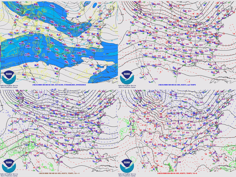 |
| Four panel (300/500/700/850mb) look at the large scale features that led to the fire weather event. Winds out of the west-southwest through the atmosphere occurred for an extended period of time, progressively drying out conditions at the ground, as these winds tend to bring much drier air over the Panhandles as most moisture falls on the windward side of the Rockies. Additionally, an upper trough approached, causing wind speeds aloft to markedly increase going into the 26th and 27th, leading to stronger winds at the ground. |
 |
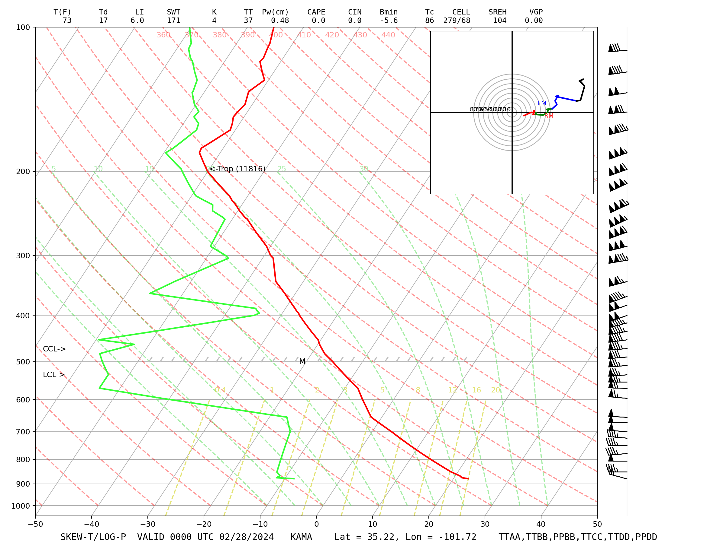 |
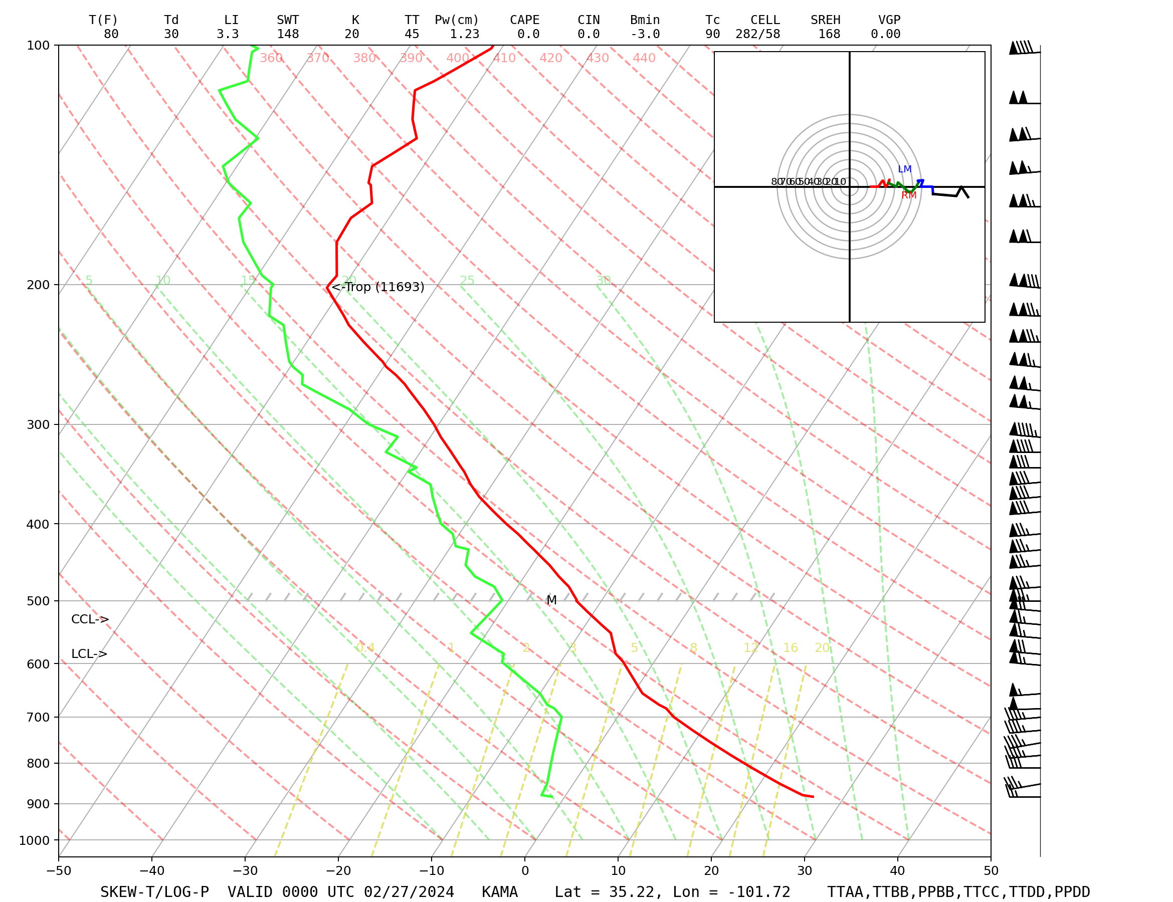
| Late afternoon Amarillo weather ballon data from the 26th (left) and 27th (right). Dewpoint is traced in green and temperature in red; lots of space between these lines indicates low relative humidity at that altitude in the weather balloon launch. Conditions, while not as dry as it can get around here, were dry enough for fires to ignite. The bigger issue? Check out the measured winds plotted on the right; full barbs are 10 knots (12 mph), half barbs are 5 knots (6 mph) and the flags are 50 knots (58 mph). Strong winds are present through the troposphere, leading to strong winds at the ground. These winds caused fires to spread rapidly and led to some of the fire starts by toppling power poles. | |
Additional environmental data.
 |
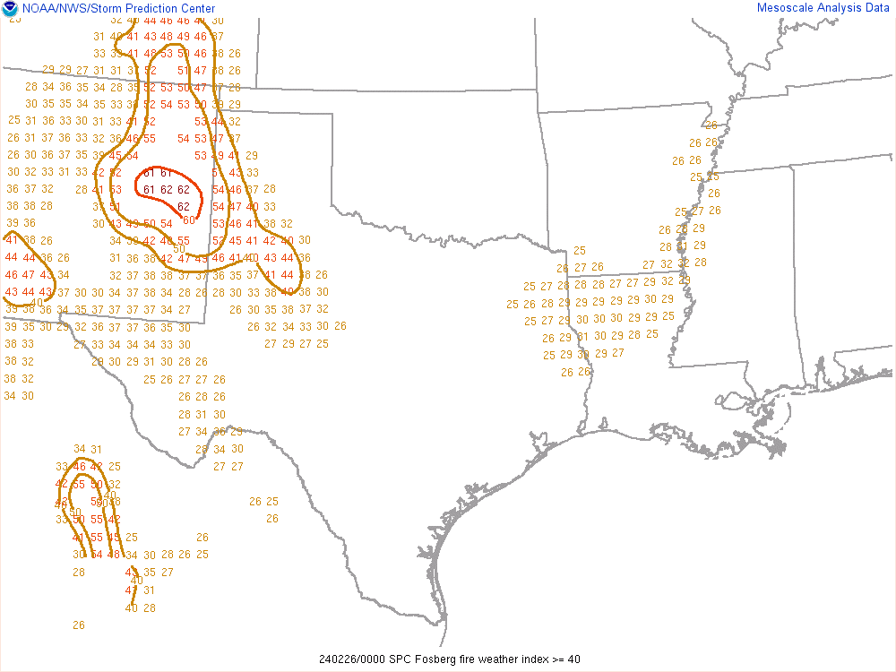 |
| Analysis of surface pressure and surface pressure change over the past two hours. Tightly packed isobars (black lines) indicate the presence of a strong pressure gradient, which leads to strong winds. One can also see the quick change in wind direction from out of the west-southwest to out of the northeast. The strong pressure gradient following the frontal passage meant that strong winds continued even after the shift in direction. | Analysis of Fosberg Index, a composite variable that attempts to quantify how dangerous the combination of relative humdity and winds are for fire spread. Values range from 0 to 100 with 100 being the most dangerous. |
 |
Media use of NWS Web News Stories is encouraged! Please acknowledge the NWS as the source of any news information accessed from this site. |
|

