Overview
Heavy rain fell over much of West Texas and the Panhandles early in October.
A large upper level storm system slowly evolved and deepened across the southwest United States Saturday and Sunday, October 6th-7th. The low pressure system peaked in intensity just west of the Four Corners Region on Monday, October 8th, before lifting strongly north/northeast towards the Northern Plains. This system drew copious amounts of moisture north across much of West Texas, the Panhandles, Oklahoma, and northeast towards the Midwest and brought heavy rainfall to the Panhandles at times over a four day stretch beginning late Friday and ending early Tuesday (October 5-9).
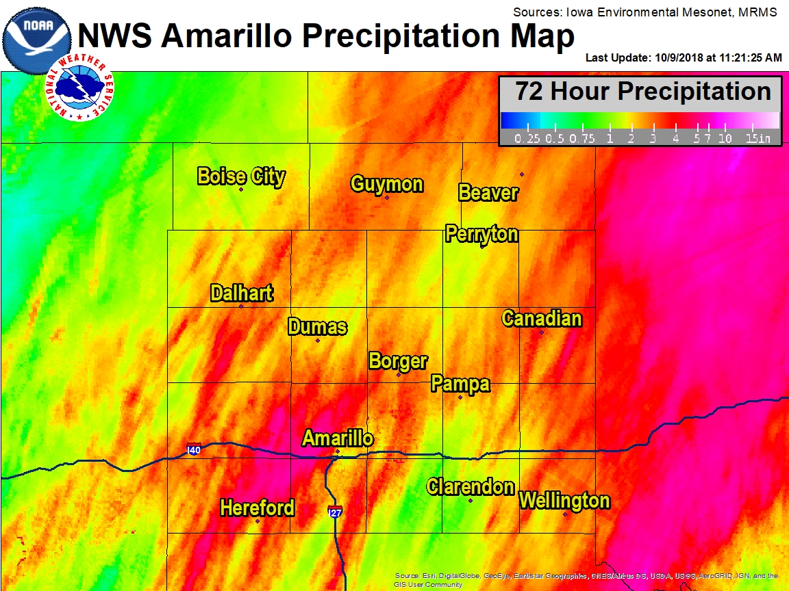
The band of highest moisture provided a large area of high rainfall totals that reached 5-8 inches just across the border in western Oklahoma. Just on the edge of this band, the far eastern Panhandles averaged 2 to 4 inches, but there were some isolated higher amounts. A developing jet stream east of the low produced a secondary area of higher rainfall totals just west of Amarillo. This is where the greatest flood impacts for the event were observed for the Panhandles region.
In the end, 4-7 inches of rain fell from the west side of Amarillo to near Vega, Texas. This produced widespread street flooding at times Sunday through Tuesday morning. Bushland was hit hardest and during the peak of the heavier rainfall water was flowing down entire streets to the point that it was across front yards to the edges of homes. Some metal shops and garages were flooded, but no reports of flood waters entering households were received. In addition, runoff and heavy rainfall resulted in entire fields becoming lakes with some Playa Lakes becoming completely filled after being dry over the last 2 years - an impressive feat.
Storms briefly became severe on Saturday as the sun finally broke out across the southwestern Texas Panhandle. A cool and somewhat stable air mass mostly limited the severe storm potential most of the event, which was fortunate as the severe storm threat could have been significant with just modest heating. Two tornadoes were reported across Castro County Saturday afternoon and rotating storms prompted additional tornado warnings across Deaf Smith and Potter/Randall Counties. Some reports of one-inch hail were received around the Hereford area, but the main impact from these storms was heavy rainfall west of Amarillo.
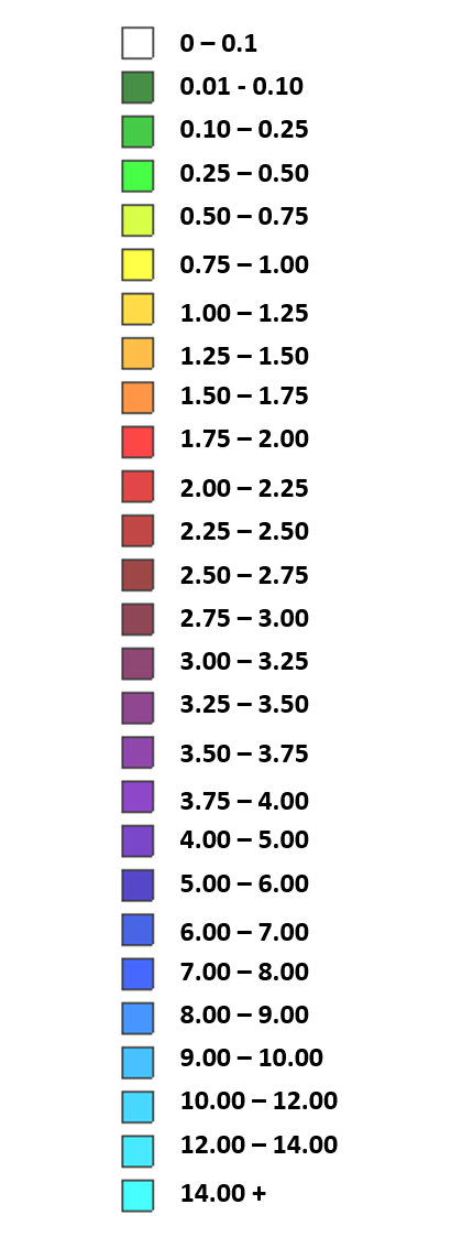
Rainfall Map below shows 72 hour rainfall ending at ~11:20am October 9th.
Rain Reports
Rainfall Sorted by County:
Friday through 8 AM Tuesday totals

Location                     Amount    Time/Date       Provider

...Oklahoma...

...Beaver County...
Beaver River                 2.97 in   0700 AM 10/09   GOES

...Cimarron County...
1 NNE Kenton                 1.99 in   0715 AM 10/09   HADS

...Texas County...
Guymon Muni Ap               3.91 in   0653 AM 10/09   ASOS
2 SE Goodwell                3.57 in   0730 AM 10/09   GOES
Goodwell 7 N                 3.15 in   0730 AM 10/09   USGS
Goodwell 2 E              0.01 in   0810 PM 10/08   AWOS

...Texas...

...Armstrong County...
Claude 12 SW                 2.79 in   0700 AM 10/09   WT-MESO
Goodnight                    1.21 in   0700 AM 10/09   WT-MESO
Palo Duro (JA) 4 E           0.88 in   0700 AM 10/09   WT-MESO
Wayside - Red River          0.78 in   0700 AM 10/09   GOES

...Carson County...
Panhandle 1 SSW              3.79 in   0700 AM 10/09   WT-MESO

...Collingsworth County...
Dozier 3 W                   3.56 in   0700 AM 10/09   WT-MESO
Salt Fork Of Red River Near  2.48 in   0700 AM 10/09   GOES

...Dallam County...
4 WSW Ware                   2.17 in   0740 AM 10/09   CWOP
Texline                      1.22 in   0746 AM 10/09   CWOP
9 E Sedan                    1.03 in   0745 AM 10/09   CWOP

...Deaf Smith County...
Hereford Airport             2.66 in   0655 AM 10/09   AWOS
Bootleg RAWS                 2.31 in   0703 AM 10/09   RAWS
2 ENE Hereford               2.22 in   0700 AM 10/09   COCORAHS
Tierra Blanca Creek Above Bu 2.17 in   0700 AM 10/09   OTHER
2 ENE Hereford CWOP          1.89 in   0743 AM 10/09   CWOP
Bootleg WTM                  1.65 in   0700 AM 10/09   WT-MESO
Hereford North CWOP          1.63 in   0745 AM 10/09   CWOP
Hereford South CWOP          1.39 in   0743 AM 10/09   CWOP

...Donley County...
4 ENE Lelia Lake             2.17 in   0745 AM 10/09   GOES
Greenbelt Lake               0.89 in   0730 AM 10/09   GOES
Clarendon 2 WSW              0.85 in   0735 AM 10/09   WT-MESO

...Gray County...
Pampa 2 E                    4.15 in   0735 AM 10/09   WT-MESO
Radio Station KGRO           3.53 in   0630 AM 10/09   COOP
Mclean 1 E                   2.58 in   0735 AM 10/09   WT-MESO
Lefors                       2.42 in   0700 AM 10/09   HADS

...Hansford County...
Gruver                       2.49 in   0650 AM 10/09   COOP
6 W Spearman                 2.04 in   0730 AM 10/09   HADS
Spearman                     0.49 in   0745 AM 10/09   GOES

...Hartley County...
Dalhart Municipal Airport    2.56 in   0653 AM 10/09   ASOS
Cramer Creek                 1.27 in   0730 AM 10/09   GOES
2 E Channing                 0.03 in   0730 AM 10/09   HADS

...Hemphill County...
Canadian                     4.77 in   0745 AM 10/09   CWOP
Canadian 6 E                 3.49 in   0700 AM 10/09   WT-MESO
1 NNE Canadian               0.33 in   0745 AM 10/09   HADS
Hemphill Co Arpt             0.30 in   0655 AM 10/09   AWOS

...Hutchinson County...
Stinnett 1 NW                3.21 in   0700 AM 10/09   WT-MESO
Borger                       2.91 in   0700 AM 10/09   COCORAHS
Sanford 2 WSW                2.82 in   0735 AM 10/09   RAWS
Hutchinson County Airport    2.71 in   0651 AM 10/09   ASOS

...Lipscomb County...
Lipscomb                     4.17 in   0645 AM 10/09   USARMY-COE

...Moore County...
Fritch 1 WNW                 3.19 in   0700 AM 10/09   WT-MESO
Dumas                        1.64 in   0655 AM 10/09   AWOS

...Ochiltree County...
Perryton                     1.79 in   0655 AM 10/09   AWOS

...Oldham County...
Boys Ranch 1 WSW             4.22 in   0700 AM 10/09   WT-MESO
Adrian 6 WSW                 2.91 in   0700 AM 10/09   WT-MESO

...Potter County...
6 NE Bushland                7.59 in   0700 AM 10/09   COCORAHS
5 ENE Bushland               5.44 in   0745 AM 10/09   CWOP
2 W Amarillo                 4.98 in   0700 AM 10/09   COCORAHS
Amarillo 15 NW               4.47 in   0700 AM 10/09   WT-MESO
12 SSE Masterson             4.14 in   0715 AM 10/09   HADS
Amarillo 9 NNE               3.84 in   0700 AM 10/09   WT-MESO
1 WSW Amarillo               3.48 in   0743 AM 10/09   CWOP
Amarillo                     2.47 in   0653 AM 10/09   ASOS

...Randall County...
6 W Amarillo                 4.61 in   0742 AM 10/09   CWOP
Umbarger 3 NNE               4.09 in   0700 AM 10/09   WT-MESO
Palo Duro Canyon Floor       4.01 in   0700 AM 10/09   WT-MESO
Palo Duro Canyon Rim         3.74 in   0700 AM 10/09   WT-MESO
Amarillo 7 SSE               1.76 in   0700 AM 10/09   WT-MESO

...Wheeler County...
Shamrock 3 N                 2.87 in   0645 AM 10/09   USARMY-COE
4 E Wheeler                  2.82 in   0652 AM 10/09   RAWS
8 ENE Wheeler                2.69 in   0645 AM 10/09   GOES
Wheeler                      1.37 in   0700 AM 10/09   GOES

Observations are collected from a variety of sources with varying
equipment and exposures. We thank all volunteer weather observers
for their dedication. Not all data listed are considered official.
Rainfall Sorted by Total Amounts:
     Friday through 8 AM Tuesday totals
     Sorted by value

Location                     Amount    Time/Date       Provider
6 NE Bushland                7.59 in   0700 AM 10/09   COCORAHS
5 ENE Bushland               5.50 in   0800 AM 10/09   CWOP
2 W Amarillo                 4.98 in   0700 AM 10/09   COCORAHS
Lipscomb                     4.87 in   0745 AM 10/09   USARMY-COE
Canadian                     4.77 in   0745 AM 10/09   CWOP
6 W Amarillo                 4.72 in   0757 AM 10/09   CWOP
Amarillo 15 NW               4.47 in   0700 AM 10/09   WT-MESO
Boys Ranch 1 WSW             4.22 in   0700 AM 10/09   WT-MESO
Pampa 2 E                    4.20 in   0745 AM 10/09   WT-MESO
12 SSE Masterson             4.14 in   0715 AM 10/09   HADS
Umbarger 3 NNE               4.09 in   0700 AM 10/09   WT-MESO
Palo Duro Canyon Floor       4.01 in   0700 AM 10/09   WT-MESO
Guymon Muni Ap               3.91 in   0653 AM 10/09   ASOS
Amarillo 9 NNE               3.84 in   0700 AM 10/09   WT-MESO
Panhandle 1 SSW              3.79 in   0700 AM 10/09   WT-MESO
Palo Duro Canyon Rim         3.74 in   0700 AM 10/09   WT-MESO
Dozier 3 W                   3.60 in   0700 AM 10/09   WT-MESO
2 SE Goodwell                3.57 in   0730 AM 10/09   GOES
Radio Station KGRO           3.53 in   0630 AM 10/09   COOP
Canadian 6 E                 3.49 in   0700 AM 10/09   WT-MESO
1 WSW Amarillo               3.48 in   0758 AM 10/09   CWOP
4 E Wheeler                  3.25 in   0752 AM 10/09   RAWS
Stinnett 1 NW                3.21 in   0700 AM 10/09   WT-MESO
Fritch 1 WNW                 3.19 in   0700 AM 10/09   WT-MESO
Goodwell 7 N                 3.15 in   0730 AM 10/09   USGS
Beaver River                 2.97 in   0700 AM 10/09   GOES
Shamrock 3 N                 2.92 in   0745 AM 10/09   USARMY-COE
Adrian 6 WSW                 2.91 in   0700 AM 10/09   WT-MESO
Borger                       2.91 in   0700 AM 10/09   COCORAHS
Sanford 2 WSW                2.82 in   0735 AM 10/09   RAWS
Claude 12 SW                 2.79 in   0700 AM 10/09   WT-MESO
8 ENE Wheeler                2.73 in   0745 AM 10/09   GOES
Hutchinson County Airport    2.71 in   0651 AM 10/09   ASOS
Hereford Airport             2.66 in   0655 AM 10/09   AWOS
Mclean 1 E                   2.63 in   0745 AM 10/09   WT-MESO
Dalhart Municipal Airport    2.56 in   0653 AM 10/09   ASOS
Gruver                       2.49 in   0650 AM 10/09   COOP
Salt Fork Of Red River Near  2.48 in   0700 AM 10/09   GOES
Amarillo                     2.47 in   0653 AM 10/09   ASOS
Lefors                       2.43 in   0700 AM 10/09   HADS
Bootleg RAWS                 2.31 in   0703 AM 10/09   RAWS
2 ENE Hereford               2.22 in   0700 AM 10/09   COCORAHS
4 WSW Ware                   2.18 in   0755 AM 10/09   CWOP
4 ENE Lelia Lake             2.17 in   0745 AM 10/09   GOES
Tierra Blanca Creek Above Bu 2.17 in   0700 AM 10/09   OTHER
6 W Spearman                 2.04 in   0730 AM 10/09   HADS
1 NNE Kenton                 1.99 in   0715 AM 10/09   HADS
2 ENE Hereford CWOP          1.90 in   0758 AM 10/09   CWOP
Perryton                     1.79 in   0655 AM 10/09   AWOS
Amarillo 7 SSE               1.76 in   0700 AM 10/09   WT-MESO
Bootleg WTM                  1.65 in   0700 AM 10/09   WT-MESO
Hereford North CWOP          1.65 in   0759 AM 10/09   CWOP
Dumas                        1.64 in   0655 AM 10/09   AWOS
Hereford South CWOP          1.40 in   0758 AM 10/09   CWOP
Wheeler                      1.37 in   0700 AM 10/09   GOES
Cramer Creek                 1.27 in   0730 AM 10/09   GOES
Texline                      1.22 in   0746 AM 10/09   CWOP
Goodnight                    1.21 in   0700 AM 10/09   WT-MESO
9 E Sedan                    1.03 in   0800 AM 10/09   CWOP
Greenbelt Lake               0.89 in   0730 AM 10/09   GOES
Palo Duro (JA) 4 E           0.88 in   0700 AM 10/09   WT-MESO
Clarendon 2 WSW              0.85 in   0745 AM 10/09   WT-MESO
Wayside - Red River          0.78 in   0700 AM 10/09   GOES
Spearman                     0.49 in   0745 AM 10/09   GOES
1 NNE Canadian               0.33 in   0745 AM 10/09   HADS
Hemphill Co Arpt             0.30 in   0655 AM 10/09   AWOS
2 E Channing                 0.03 in   0730 AM 10/09   HADS
Ok Goodwell 2 E              0.01 in   0810 PM 10/08   AWOS

Observations are collected from a variety of sources with varying
equipment and exposures. We thank all volunteer weather observers
for their dedication. Not all data listed are considered official.
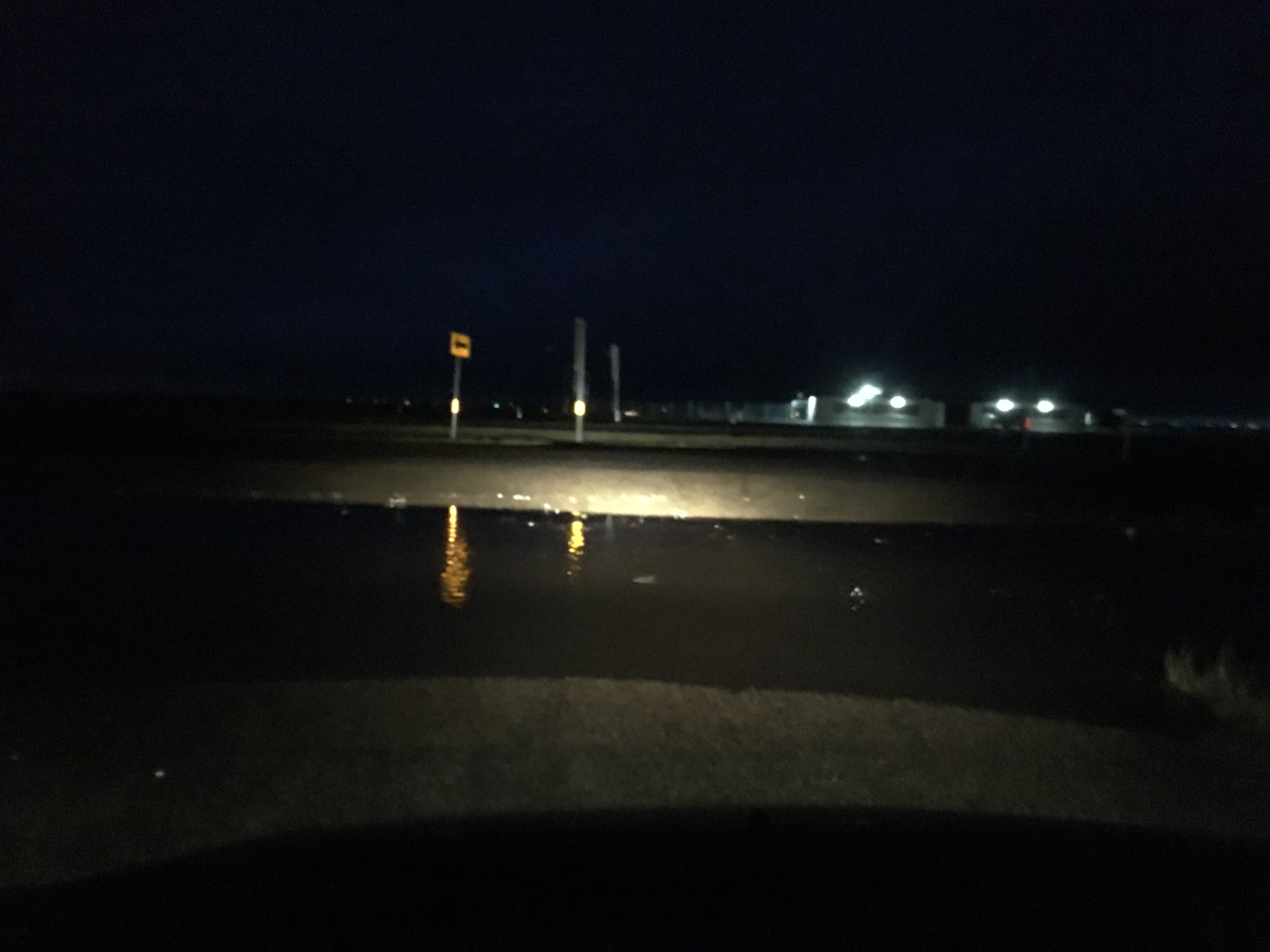
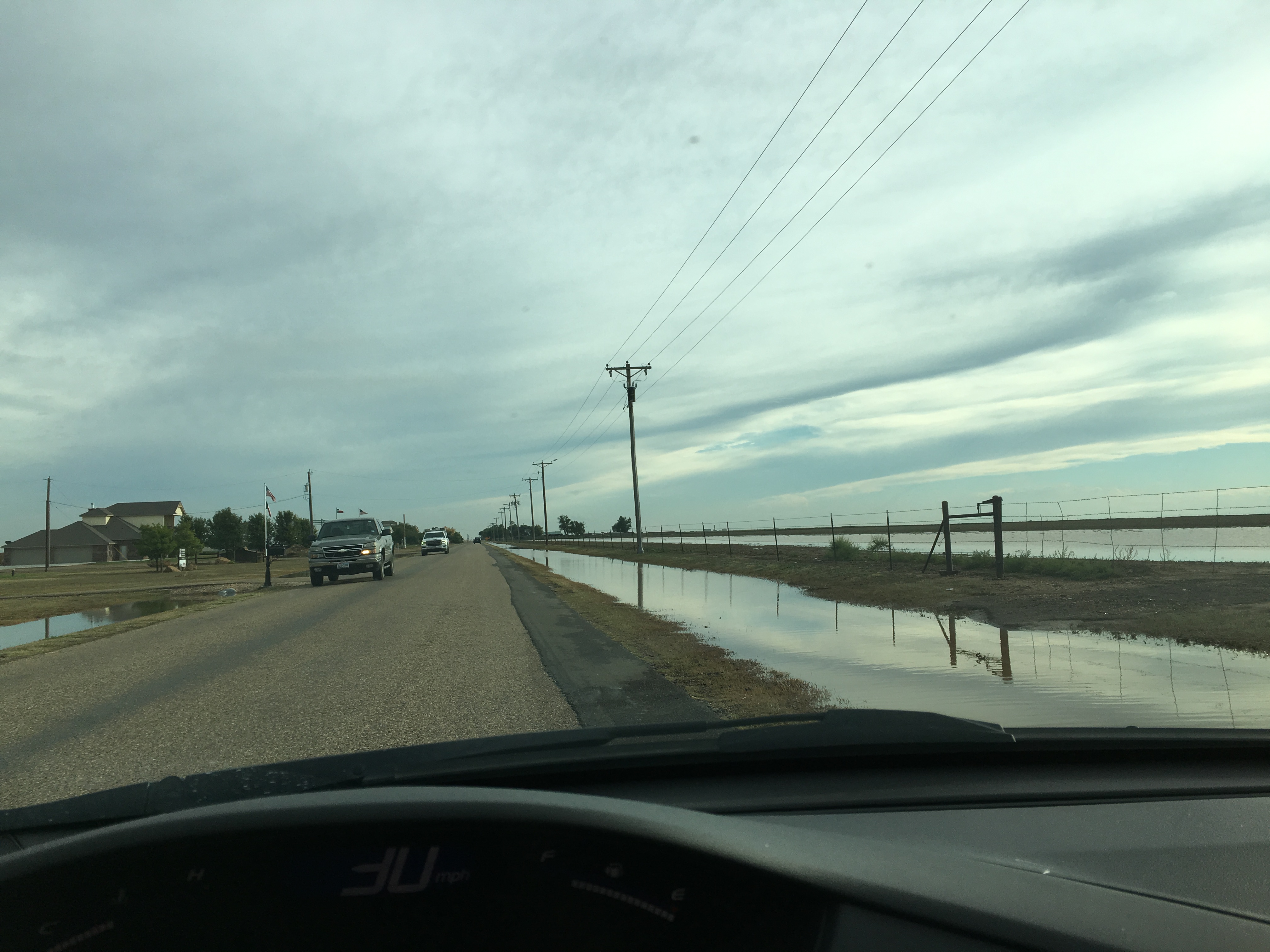
Photos
Click on images to enlarge
| Frontage road near Bushland | Blessen Road near Bushland | Arnot Road near Bushland |
 |
 |
 |
| Cadillac Ranch | Gas station on 45th and Western (Amarillo) | Cadillac Ranch |
 |
 |
 |
Records
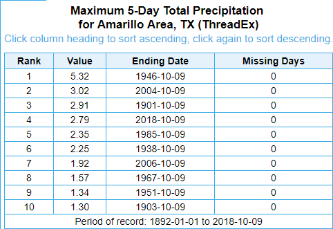
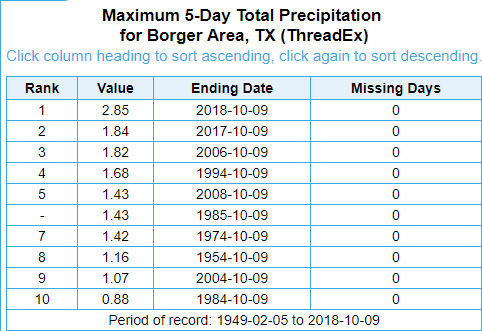
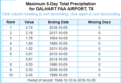
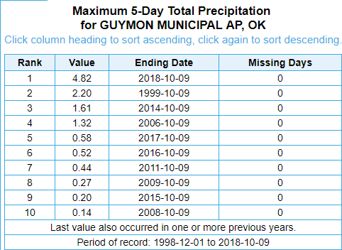
Rainfall records for the 5-day stretch of Oct 5th-9th for our primary climate sites: Amarillo, Borger, and Dalhart. Guymon is listed but does not officially have 30 years of records for "normals", so its not an "official" climate site until 10 more years of data come in.
| Amarillo Area 4th All Time Record (2.79") | Borger Area Record Set (2.85") |
 |
 |
| Dalhart Record Set (2.74") | Guymon Record Set (4.82") |
 |
 |
 |
Media use of NWS Web News Stories is encouraged! Please acknowledge the NWS as the source of any news information accessed from this site. |
|

