Overview
An upper level low pressure system moved over southern California and then Arizona by Wednesday afternoon, 13th December. With decent mid level lift ahead of the system across the southern High Plains, along with good moisture transport from the eastern Pacific and the Gulf of America, several rounds of rain occurred across the combined Panhandles on the 13th and again on the 14th. During the early AM hours Thursday morning (12/14), the NW Panhandles changed over to snow where 2-4" occurred before noon on the 14th. During the afternoon much of the northwest as well as the central Oklahoma Panhandle saw light precipitation that periodically changed back into snow or a rain/snow mix. However, surface temperatures just above freezing had the snow melting on contact, especially on pavement. Rain persisted in the eastern combined Panhandles throughout the day on Thursday the 14th, with some isolated thunderstorms developing over the central Texas Panhandle during the afternoon. As the center of the upper level low pressure system passed over the northern combined Panhandles Thursday night into early Friday morning, wrap around moisture met with colder overnight temperatures allowing for a band of snow to accumulate across the north central and northeastern combined OK/ TX Panhandles. This light band of snow that developed on the backside of the departing low brought 1-2" of snowfall reaching from Stratford TX ENE towards Beaver, OK. As soon as the sun came up and the rest of the clouds exited the area, the accumulated snow across the north central and northeastern combined Panhandles melted quickly with warm temperatures and the nature of the wet heavy snow.
Precipitation totals across the Panhandles ranged from just under an inch to just over 5" for portions of the SE TX Panhandle. Snowfall ratios were 4-5:1, where heavy wet snow occurred which did impose some minor impacts to travel in the NW Panhandles. Overall this was an abnormally wet system for a Panhandle December, putting the majority of the area well above the December normal for liquid precipitation.
Snow/Ice
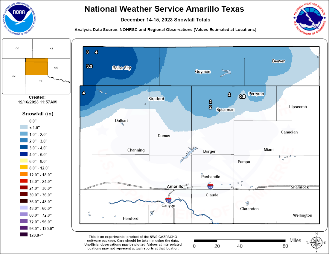 |
| Map of estimated snowfall across the Oklahoma and Texas Panhandles from December 12th, 2023 through December 15th, 2023 using ground reports. |
| Location | Snowfall | Source |
| Texline | 4 | COOP |
| 6.1 E Kenton | 4 | CoCoRaHs |
| Boise City | 3.5 | COOP |
| 12.1 S Kenton | 3.3 | CoCoRaHs |
| Kenton | 3 | Public |
| 9 NW Waka | 2 | Public |
| Perryton | 2 | Public |
| 1 N Gruver | 2 | Public |
| Gruver | 2 | Public |
| Beaver | 2 | Public |
| Guymon | 1 | Public |
| Spearman | 1 | Public |
| 1 NNW Farnsworth | 0.8 | Public |
| Amarillo | 0 | Public |
Radar and Photos
| Composite radar reflectivity through the event. Radar data from NWS; visualization from Iowa Environmental Mesonet |
 |
 |
 |
 |
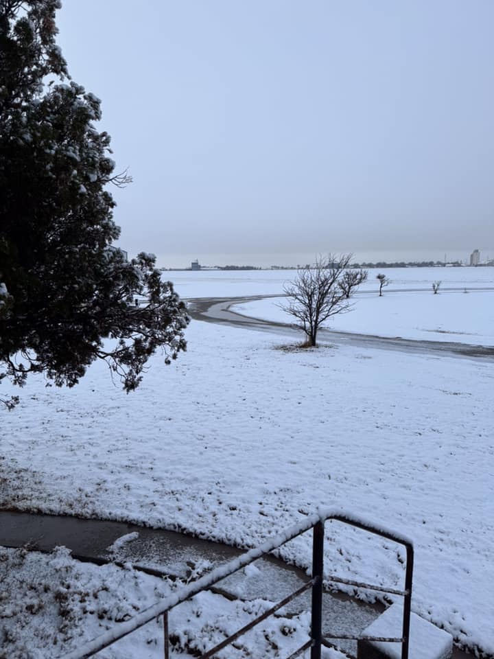
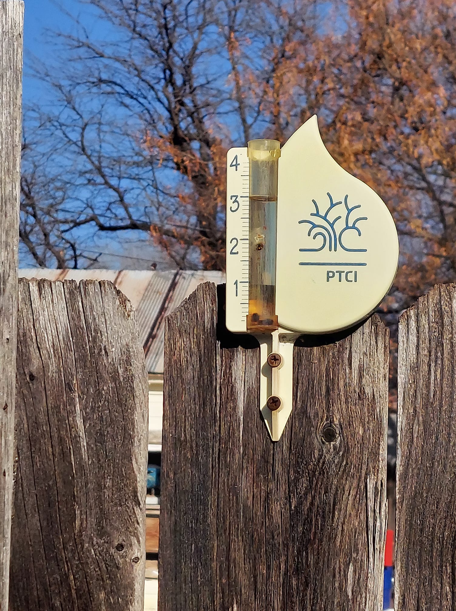
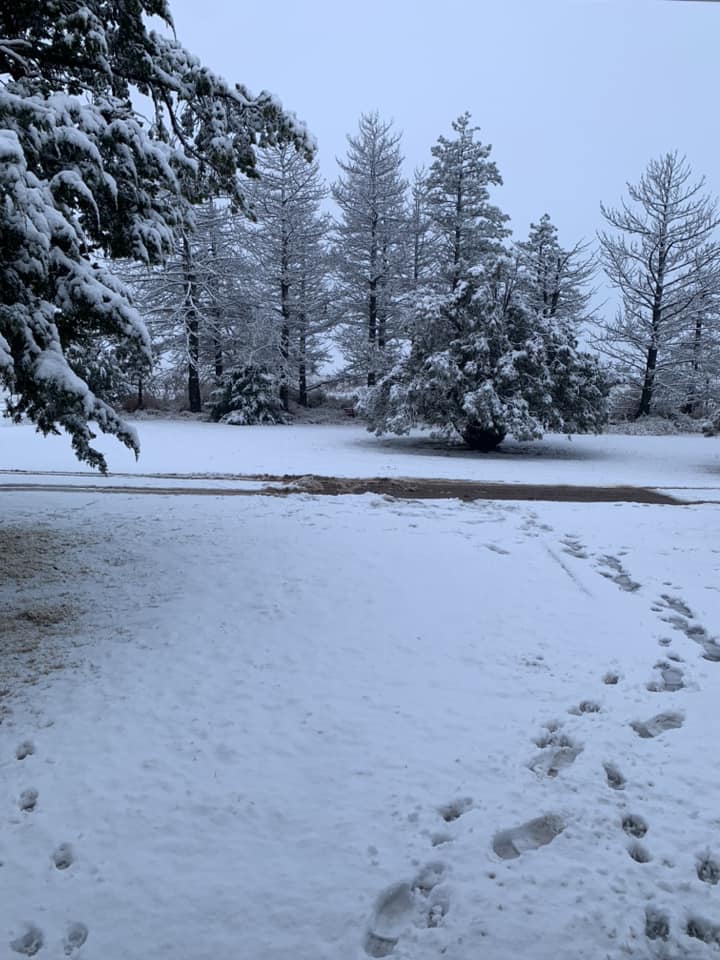
| Snow west of Perryton (Vicki Gaines Gurley) | Three inches of rain measured in Guymon (Tim Brittain) | Snow in Balko (Sherry Parker) | More than 2 and a half inches in Perryton (Aaron Moore) |
Rain Reports
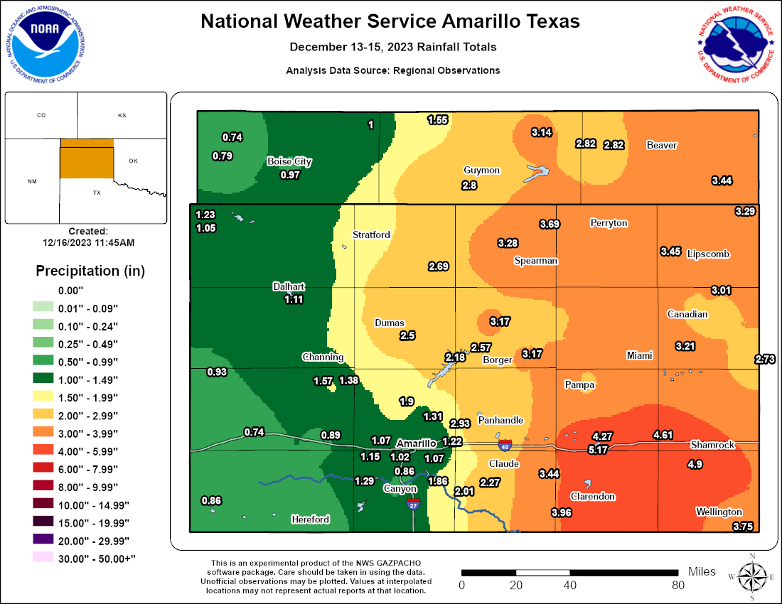 |
| Map of estimated rainfall across the Oklahoma and Texas Panhandles from December 12th, 2023 through December 15th, 2023 using rain gauge reports and radar estimates. |
| Location | County | Type | Rainfall |
| Jericho | Gray | COOP | 5.17 |
| Clarendon 2 WSW | Donley | WT Mesonet | 4.94 |
| Dozier 3 W | Collingsworth | WT Mesonet | 4.9 |
| McLean 1 E | Gray | WT Mesonet | 4.61 |
| Lake McClellan 2 NW | Gray | WT Mesonet | 4.27 |
| Palo Duro 4 E/JA Ranch | Armstrong | WT Mesonet | 3.96 |
| Wellington 6 SE | Collingsworth | WT Mesonet | 3.75 |
| Palo Duro Reservoir 1 NW | Hansford | WT Mesonet | 3.69 |
| Lipscomb 8 W | Lipscomb | WT Mesonet | 3.45 |
| Slapout 8 W | Beaver | OK Mesonet | 3.44 |
| Goodnight | Armstrong | WT Mesonet | 3.44 |
| Follett | Lipscomb | COOP | 3.29 |
| Gruver | Hansford | COOP | 3.28 |
| Beaver 1 SSW | Beaver | OK Mesonet | 3.28 |
| Miami 10 E | Hemphill | WT Mesonet | 3.21 |
| Borger 7 E | Hutchinson | WT Mesonet | 3.17 |
| Stinnett 1 NNW | Hutchinson | WT Mesonet | 3.17 |
| Hooker 1 W | Texas | OK Mesonet | 3.14 |
| Pampa | Gray | COOP | 3.05 |
| Glazier | Hemphill | COOP | 3.01 |
| Pantex 1 ESE | Carson | WT Mesonet | 2.93 |
| Pampa 2 E | Gray | WT Mesonet | 2.83 |
| Turpin 6.1 SSE | Beaver | CoCoRaHs | 2.82 |
| Turpin 5.2 S | Beaver | CoCoRaHs | 2.82 |
| Goodwell 2 E | Texas | OK Mesonet | 2.8 |
| Borger | Hutchinson | ASOS | 2.74 |
| Hemphill SE | Hemphill | COOP | 2.73 |
| Canadian 6 E | Hemphill | WT Mesonet | 2.72 |
| Sunray 9 NNE | Sherman | WT Mesonet | 2.69 |
| Borger 0.7 NNE | Hutchinson | CoCoRaHs | 2.66 |
| Sanford Dam | Hutchinson | COOP | 2.57 |
| Guymon | Texas | ASOS | 2.54 |
| Dumas 3 SE | Moore | WT Mesonet | 2.5 |
| Panhandle 1 SSW | Carson | WT Mesonet | 2.46 |
| Claude 12 SW/North Rim PDC | Armstrong | WT Mesonet | 2.27 |
| Fritch 1 WNW | Moore | WT Mesonet | 2.18 |
| Palo Duro Canyon SP Floor | Randall PDC | WT Mesonet | 2.01 |
| Amarillo 15 NNW | Potter | WT Mesonet | 1.9 |
| Palo Duro Canyon SP Rim | Randall | WT Mesonet | 1.86 |
| Boys Ranch 1 WSW | Oldham | WT Mesonet | 1.57 |
| Eva 12 NE | Texas | OK Mesonet | 1.55 |
| Stratford 4 WNW | Sherman | WT Mesonet | 1.54 |
| Pantex 4 WSW | Carson | WT Mesonet | 1.53 |
| Boys Ranch | Oldham | COOP | 1.38 |
| Amarillo 9 NNE | Potter | WT Mesonet | 1.31 |
| Umbarger 3 NNE | Randall | WT Mesonet | 1.29 |
| Texline 2 N | Dallam | WT Mesonet | 1.23 |
| Amarillo | Potter | ASOS | 1.22 |
| AMA WFO | Potter | COOP | 1.22 |
| Bushland 1 WSW | Potter | COOP | 1.15 |
| Dalhart 2 SE | Hartley | COOP | 1.14 |
| Dalhart | Hartley | ASOS | 1.11 |
| Amarillo 7 SSE | Randall | WT Mesonet | 1.07 |
| Amarillo 10.0 W | Potter | CoCoRaHs | 1.07 |
| Texline | Dallam | COOP | 1.05 |
| Amarillo 5.9 WSW | Potter | CoCoRaHs | 1.02 |
| Keyes 10.3 NE | Cimarron | CoCoRaHs | 1 |
| Boise City 3 SSE | Cimarron | OK Mesonet | 0.97 |
| Romero 11 SSW/Bravo Ranch | Oldham | WT Mesonet | 0.93 |
| Canyon 1W | Randall | WT Mesonet | 0.93 |
| Hereford 2 NW | Deaf Smith | WT Mesonet | 0.89 |
| Vega 4 E | Oldham | WT Mesonet | 0.89 |
| Hereford 1.1 N | Deaf Smith | CoCoRaHs | 0.88 |
| Hereford 2.4 ENE | Deaf Smith | CoCoRaHs | 0.87 |
| Bootleg 11 WNW | Deaf Smith | WT Mesonet | 0.86 |
| Canyon 4.2 NNE | Randall | CoCoRaHs | 0.86 |
| Kenton 12.1 S | Cimarron | CoCoRaHs | 0.79 |
| Kenton 5 SE | Cimarron | OK Mesonet | 0.74 |
| Adrian 6WSW | Oldham | WT Mesonet | 0.74 |
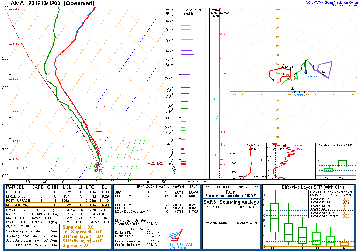
Environment
| Figure 1: A 4 panel look at objective analyses of weather balloon data from the event. Top left is a 300mb chart, top right is a 500mb chart, bottom left is a 700mb chart, and bottom right is a 850mb chart. In the 300/500mb panels, we see a deep but slowly progressing upper trough - multiple disturbances would eject northeastward around this and lead to multiple rounds of rainfall. The green contours in the 700/850mb charts show the deep moisture that was pulled northward from the Gulf of America ahead of the upper trough. |
 |
|
| Figure 2: Morning weather balloon launch on December 13th, 2023 showing deep moisture through the troposphere. | Figure 3: Loop of precipitable water, a measure of available moisture through the atmosphere, and 850mb winds through the event, showing rich moisture being pulled northwestward from the Gulf of America. Amounts were over 0.5" through the event, which only occurs about 10 percent of the time during mid December. |
Satellite loops of the system:
| Visible satellite loop of the storm system as it shifted east of the Panhandles. Snow is visible as the stationary white returns on the ground after the clouds depart. |
| Visible satellite during the height of the rain event on December 14th, 2023. Showers and a few thunderstorms are widespread across the Panhandles. Images courtesy of CSU/CIRA. |
 |
Media use of NWS Web News Stories is encouraged! Please acknowledge the NWS as the source of any news information accessed from this site. |
|

