by Chris A. Kimble
The Texas and Oklahoma Panhandles experience some wide temperature fluctuations, sometimes within a single day. The high plains is in a unique region of the United States which sees some of the largest temperature swings. The relatively high elevation, dry air, proximity to the north-south oriented Rocky Mountains, and frequency of strong cold fronts all contribute to this area having some of the wildest temperature swings in the country.
The greatest daily temperature ranges (difference between high temperature and low temperature) occur during the winter and spring months, with the highest average ranges occurring during the month of March. The map shown to the left illustrates that the high plains average temperature range in March is 30 degrees or more, while many other areas of the country average near 20 degrees.
During the winter and spring it is not unheard of to see temperature swings of 50 degrees or more within one calendar day. During the winter months this is most often associated with a strong arctic cold front which drops temperatures from the 60s or 70s down into the 10s and 20s within a few hours. These strong cold fronts originate in the arctic regions of Canada and can plunge southward very quickly across the western High Plains. The cold fronts are often stronger and move faster in this region due to the orientation of the Rocky Mountains. Northeast winds behind the front pile cold air up against the mountains, and the air has nowhere else to go but south. Temperature drops of 40 degrees have occurred in a matter of minutes as these fronts come through. Often these fronts come through without precipitation or even any noticeable cloud cover. Locals have referred to these dramatic temperature plunges as "Blue Norther's" due to their sudden shift to very cold northerly winds often under clear blue skies. More on Blue Norther's later.
During the spring months in the high plains, these extreme temperature ranges of 50 degrees or more can occur multiple days in a row with no significant cold fronts. This is because during the spring very dry air flows down from the southern Rocky Mountains into the High Plains. This dry air allows temperatures to warm up quickly during the day and cool down very quickly at night. Temperatures could be in the 30s when residents leave for work and school in the morning and warm up into the 90s 
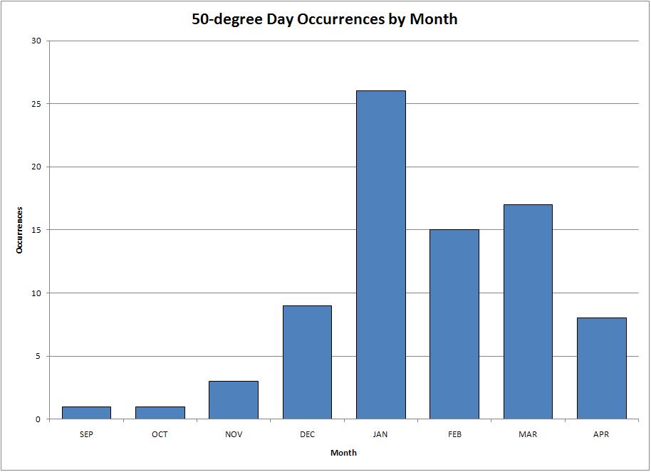
These dramatic temperature ranges do not occur during the summer months due to the increased moisture in the air. Temperatures may warm into the 100s during the afternoon but with the greater moisture, temperatures only fall into the 60s or 70s overnight. Temperature ranges of 50 degrees or more have occurred from September through April at Amarillo, with January being the month with the greatest number of these extreme ranges. The graph to the right shows the number of 50+ degree temperature ranges per month for the period 1892-2009.
Temperature ranges of 50 degrees or more are just as common now as they ever have been. In fact, 2008 tied with 1950 for the year that had the most days with temperature ranges of 50 degrees or more in Amarillo. Both years had 4 days. The 2000s decade has also had more 50 degree daily temperature spreads than any other decade. There have been 14 days so far this decade. Previously the 1950s had the most 50-degree days with 10 days. A graph of the number of days with 50+ temperature ranges per decade is available by clicking here. Several months have had multiple occurrences of these temperature extremes. On six separate occasions, temperature ranges of 50 degrees or more occurred on 3 days in the same month. Most recently this occurred in March of 2002.
As stated before, the year 2008 tied with 1950 as having the most days with 50+ degree temperature ranges in Amarillo. The graph below plots the number of days that this occurred on each year from 1892 to 2009. Data for 2009 is complete as of July 2009.
As described above, Blue Norther's occur from time to time during the winter months. Very cold air plunges southward on northerly winds and under often clear blue skies. These sudden cold snaps can catch people off guard with temperature drops of 40 degrees or more within a few minutes. The most famous Blue Norther occurred on November 11, 1911 (11/11/11) and impacted a large part of the midwestern United States. Temperature drops of 40 to 50 degrees occurred within a few minutes, and several locations set record high temperatures and record low temperatures on the same day. In Oklahoma City the record high temperature of 83 degrees occurred before the cold front came through and dropped temperatures to a record low of 17 degrees by midnight. This is a 66 degree temperature swing! Severe thunderstorms and tornadoes occurred across the Mississippi River Valley ahead of the cold front. A strong blizzard developed behind the front in Ohio. And strong winds kicked up a dust storm in Oklahoma. In fact, in Wisconsin an F4 tornado struck the town of Janesville. One hour later survivors were working through near zero visibility in blizzard conditions to rescue people trapped by debris from the tornado. In Amarillo, there were no tornadoes or blizzards, but the temperature dropped from a high of 70 degrees to a low of 13 degrees, a range of 57 degrees!
The most extreme temperature range recorded at Amarillo within one calendar day occurred from a Blue Norther' in December 1919. At noon on Friday, December 12, the temperature was 67 degrees. By 1 PM the temperature had dropped an astounding 44 degrees to a reading of 23 degrees. By 7 PM that evening the temperature had bottomed out at 1 degree above zero, a full 66 degrees lower than the high temperature 7 hours earlier.