
A prolonged, dangerous heat wave will persist through the Independence Day weekend across the Ohio Valley, Midwest, and Mid-Atlantic. Numerous temperature records are expected. Clusters of severe thunderstorms will move across parts of the Allegheny Plateau into Mid Atlantic this Independence Day, with potential for widespread damaging winds. Additional severe thunderstorms in the Great Plains. Read More >
Overview
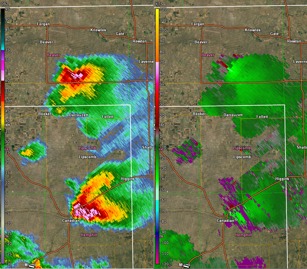
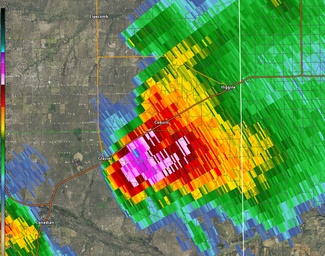
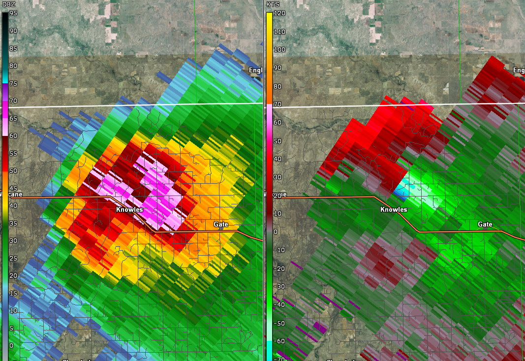
A strong area of low pressure aloft moved up into the northern Plains as an associated mid level jet advanced over the southern Plains. The right entrance region of this jet was situated over the eastern Panhandles on top of a dryline which helped bolster deep convection. A weak lee low developed over southeastern CO helping to increase convergence along the dryline during the afternoon where Thunderstorms initiated and quickly became severe. Deep layer shear vectors were normal to the boundary at around 40-50 knots resulting in discrete supercell structures. SBCAPE on the order of 3500 J/kg supported very large to giant hail. Canadian was one of the main targets in this event as the north side of town got beat up with golf ball to baseball size hail due to a "right mover". A "left mover" moved up into Beaver County at 60 mph and also dropped very large hail east of Elmwood, OK.
Fig 1: This is a base radar reflectivity loop of the June 13th event.
Fig 2: GOES 16 Cloud Top Phase IR Band for June 13th event (non-operational, preliminary data).
Photos & Video:
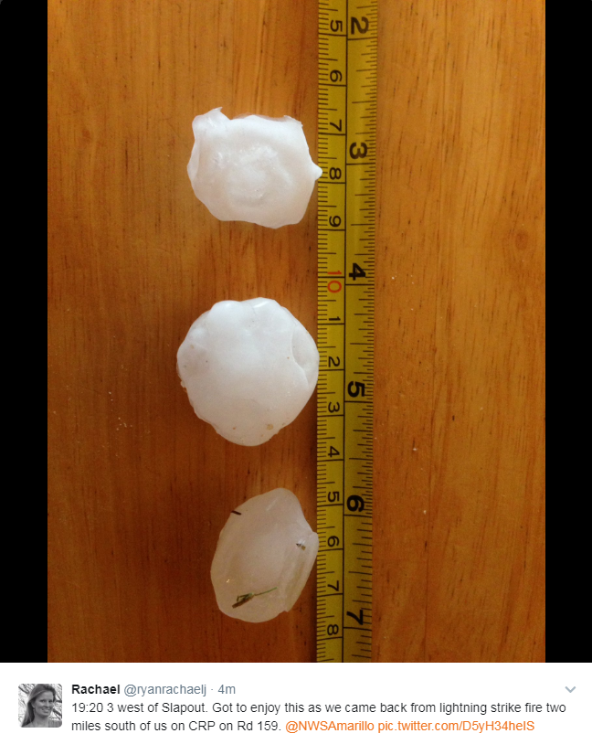
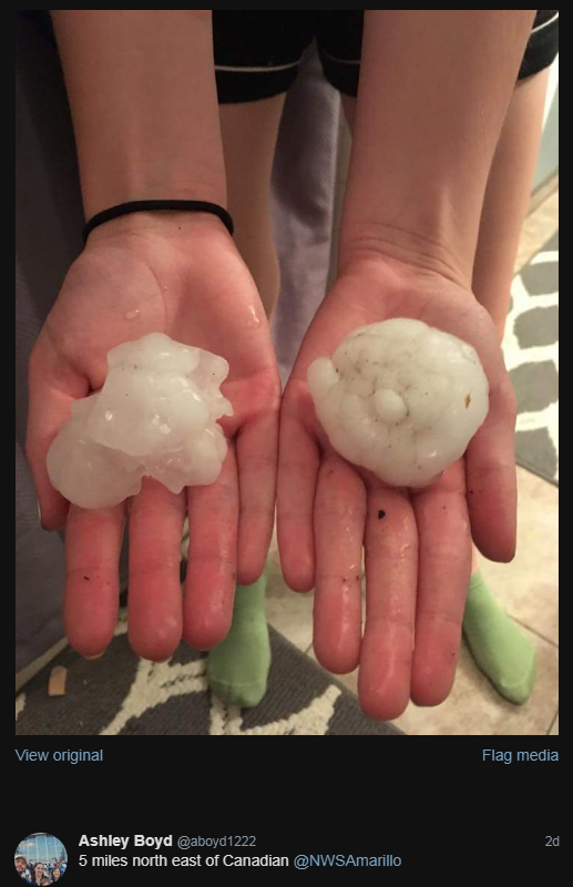
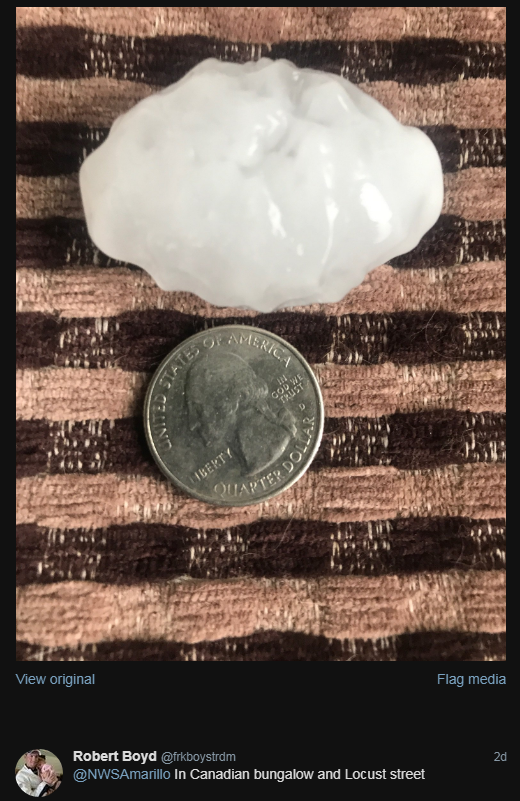
Here are some photos of the large hail and storm structure:
 |
 |
 |
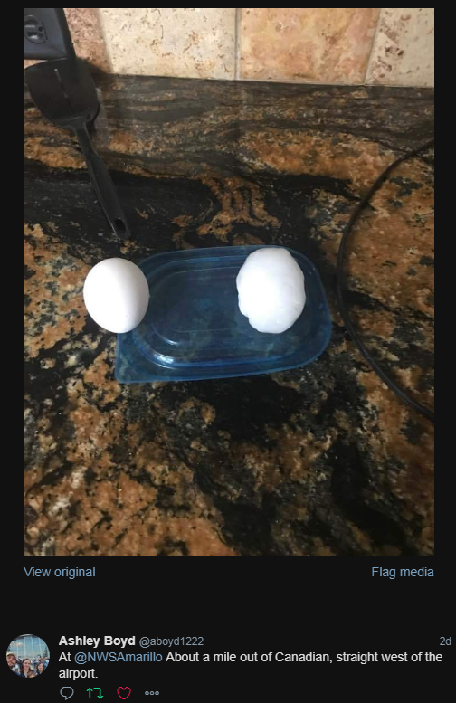 |
| Rachael sent this photo of half dollar size hail 3 miles west of Slapout | Tennis to baseball size hail 5 miles northeast of Canadian by Ashley Boyd | Ping-pong ball size hail would eventually get much bigger in Canadian by Robert Boyd | Hen Egg size hail just west of Canadian airport by Ashley Boyd |
Radar:
Header
 |
 |
 |
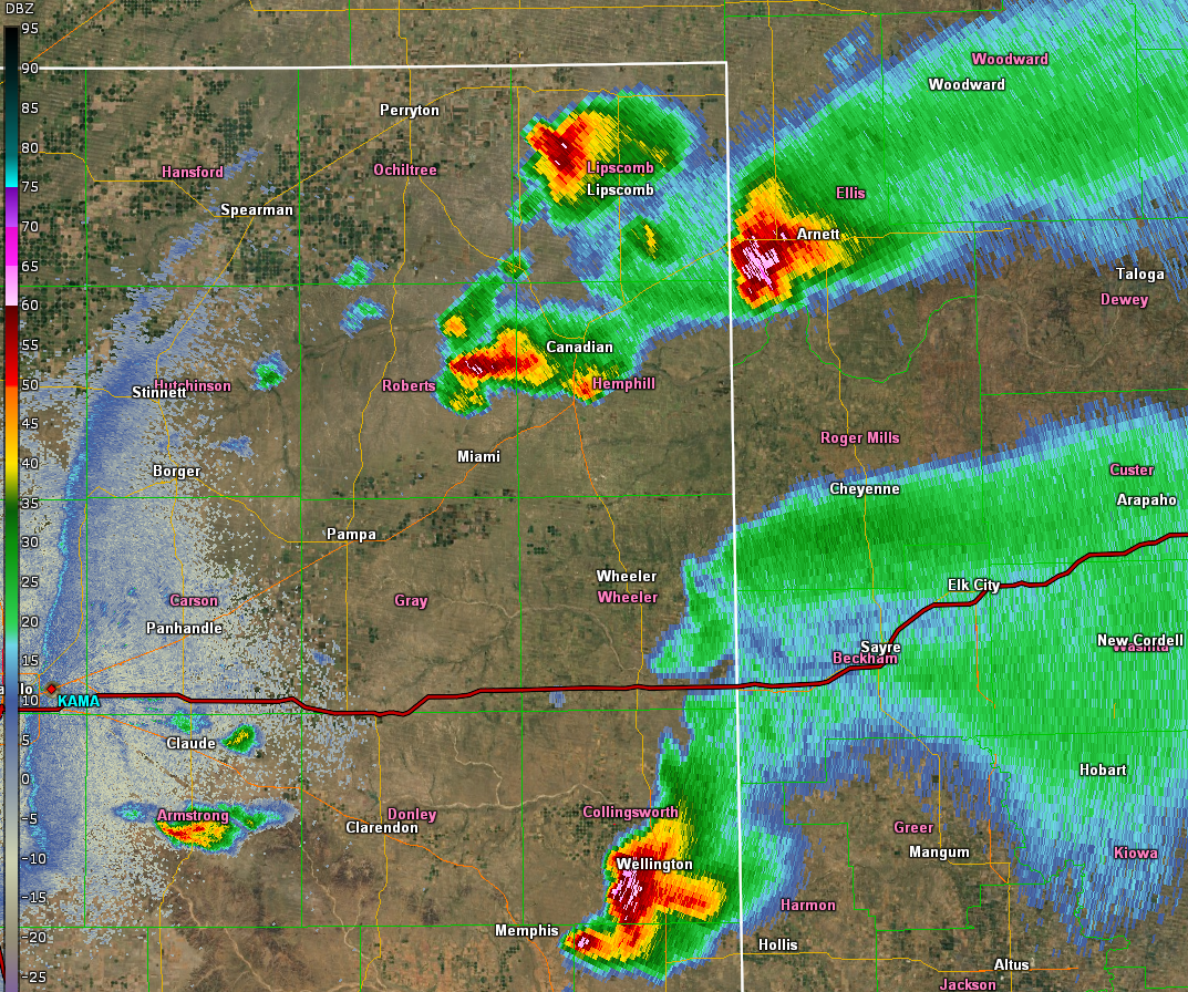 |
| Splitting supercell resulted in left mover (Beaver Co) and right mover (Hemphill Co) | Right mover had 50dBZ core over 40k feet at times with 60 dBZ over 35k feet AGL producing baseball size hail | Left mover had strong anticyclonic rotation and produced hail at least as large as hen eggs with an unconfirmed report as large as baseballs | Other severe storms continued to form east of the dryline beneath the right entrance region of an upper level jet streak. |
Storm Reports
PRELIMINARY LOCAL STORM REPORT...SUMMARY
NATIONAL WEATHER SERVICE AMARILLO TX
1112 PM CDT TUE JUN 13 2017

..TIME...   ...EVENT...      ...CITY LOCATION...     ...LAT.LON...
..DATE...   ....MAG....      ..COUNTY LOCATION..ST.. ...SOURCE....
            ..REMARKS..

0430 PM     HAIL             5 W PAMPA               35.55N 101.05W
06/13/2017  M0.88 INCH       GRAY               TX   STORM CHASER

            PEA TO MARBLE SIZE HAIL WITH NICKEL MIXED IN AT 152 AND
            PRICE IN PAMPA

0431 PM     HAIL             5 W PAMPA               35.55N 101.05W
06/13/2017  M1.00 INCH       GRAY               TX   BROADCAST MEDIA

            QUARTER SIZE HAIL REPORTED ON STATE HIGHWAY 152 WEST OF
            PAMPA.

0510 PM     HAIL             GROOM                   35.20N 101.11W
06/13/2017  M1.00 INCH       CARSON             TX   NWS EMPLOYEE

0525 PM     HAIL             9 NNW MIAMI             35.81N 100.70W
06/13/2017  M1.75 INCH       ROBERTS            TX   LAW ENFORCEMENT

0530 PM     HAIL             10 E PERRYTON           36.39N 100.62W
06/13/2017  E1.50 INCH       OCHILTREE          TX   PUBLIC

            PING PONG BALL SIZED HAIL REPORTED 10 MILES EAST OF
            PERRYTON.

0545 PM     HAIL             BOOKER                  36.46N 100.54W
06/13/2017  E1.75 INCH       LIPSCOMB           TX   FIRE DEPT/RESCUE

0550 PM     HAIL             4 NNE BOOKER            36.51N 100.51W
06/13/2017  E1.75 INCH       BEAVER             OK   TRAINED SPOTTER

0554 PM     HAIL             6 SSE ELMWOOD           36.54N 100.48W
06/13/2017  M2.00 INCH       BEAVER             OK   PUBLIC

0555 PM     HAIL             CANADIAN                35.91N 100.38W
06/13/2017  E2.50 INCH       HEMPHILL           TX   FIRE DEPT/RESCUE

            TENNIS BALL SIZED HAIL REPORTED AT 555 PM .

0555 PM     HAIL             CANADIAN                35.91N 100.38W
06/13/2017  M2.00 INCH       HEMPHILL           TX   TRAINED SPOTTER

0558 PM     HAIL             3 E CANADIAN            35.91N 100.33W
06/13/2017  E1.00 INCH       HEMPHILL           TX   PUBLIC

            QUARTER SIZED HAIL REPORTED JUST EAST OF CANADIAN.

0558 PM     HAIL             5 NNW CANADIAN          35.98N 100.42W
06/13/2017  E2.75 INCH       HEMPHILL           TX   PUBLIC

0606 PM     HAIL             11 ENE ELMWOOD          36.68N 100.34W
06/13/2017  E1.75 INCH       BEAVER             OK   LAW ENFORCEMENT

0619 PM     HAIL             6 SE HEDLEY             34.81N 100.58W
06/13/2017  E1.50 INCH       DONLEY             TX   STORM CHASER

0624 PM     HAIL             2 NE GLAZIER            36.03N 100.24W
06/13/2017  E1.75 INCH       HEMPHILL           TX   STORM CHASER

0625 PM     HAIL             6 SE HEDLEY             34.81N 100.58W
06/13/2017  M2.00 INCH       DONLEY             TX   STORM CHASER

0641 PM     HAIL             5 S HIGGINS             36.05N 100.03W
06/13/2017  E2.75 INCH       HEMPHILL           TX   STORM CHASER

0646 PM     HAIL             HIGGINS                 36.12N 100.03W
06/13/2017  E1.75 INCH       LIPSCOMB           TX   BROADCAST MEDIA

0700 PM     HAIL             1 SSE WELLINGTON        34.84N 100.21W
06/13/2017  E1.00 INCH       COLLINGSWORTH      TX   TRAINED SPOTTER

0720 PM     HAIL             3 W SLAPOUT             36.62N 100.17W
06/13/2017  M1.25 INCH       BEAVER             OK   TRAINED SPOTTER

0722 PM     HAIL             2 S SLAPOUT             36.59N 100.12W
06/13/2017  E1.50 INCH       BEAVER             OK   TRAINED SPOTTER

0843 PM     HAIL             MOBEETIE                35.53N 100.44W
06/13/2017  E1.75 INCH       WHEELER            TX   TRAINED SPOTTER
Environment (coming soon)
Insert synoptic summary.
| Figure 1: Caption | Figure 2: Caption | Figure 3: Caption |
Near-storm environment summary.
| Figure 4: Caption | Figure 5: Caption | Figure 6: Caption |
 |
Media use of NWS Web News Stories is encouraged! Please acknowledge the NWS as the source of any news information accessed from this site. |
|

