|
2014 Weather Year in Review
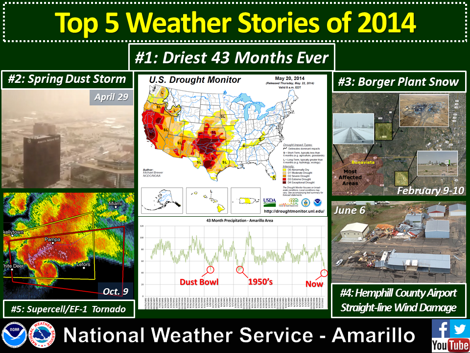
It is said that all droughts end in floods. 2014 will be remembered as one of those years for much of the Texas and Oklahoma Panhandles. Although drought conditions continued to plague the Texas and Oklahoma Panhandles throughout the year, Memorial Day weekend brought an abrupt change from historic drought to a wet growing season for the region. The region’s period of long-term drought which began in late 2010 reached historic proportions by May 2014. The 43-month period from October 2010 to April 2014 was drier than any similar period on record for many sites in the Panhandles and surrounding areas – even drier than during the 1930s Dust Bowl and 1950s droughts of record. At Amarillo, record keeping started in 1892. Exceptional Drought conditions had expanded to all of the Panhandles by Memorial Day weekend, with very little in the way of widespread rain or snow falling before that point. The spring’s annual high wind events stirred up several massive dust storms reminiscent of the Dust Bowl years.
YEAR 2014 SUMMARY FOR AMARILLO High for the year: 104 °F on August 31st
Low for the year: 1 °F on February 6th
Average High Temperature: 71.4 °F (0.4 °F above normal)
Average Low Temperature: 44.0 °F (0.2 °F above normal)
Average Annual Temperature: 57.7 °F (0.3 °F above normal)
Annual Precipitation: 19.40 inches (0.96 inches below normal)
Annual Snowfall: 9.2 inches (8.6 inches below normal)
Days with temperature ≥ 100 degrees: 5
Tornadoes: 12 Total – 9 EF-0 and 3 EF-1
Climate Graphs for 2014
Top 5 Regional Weather Events of 2014
January High: 71 °F, 12th Low: 4 °F, 28th Average: 37.0 °F (normal) Precipitation: 0.03 inches (0.69 inches below normal) Snowfall: 0.9 inches Records: No records set or tied during January. January started off the year on a dry note for the Panhandles. A few light snow events brought light amounts of precipitation to the Oklahoma Panhandle and northern Texas Panhandle, but most areas received less than 0.10 inches of precipitation for the month. Windy and dry weather throughout the month worsened drought conditions across the area. February High: 77 °F, 16th and 18th Low: 1 °F, 6th Average: 37.7 °F (2.6 °F below normal) Precipitation: 0.36 inches (0.20 inches below normal) Snowfall: 4.7 inches Records: No records set or tied during February. Drier than normal weather continued through February, though a few rounds of snow early in the month produced several inches of snow for much of the Panhandles. Bitterly cold air accompanied one of the winter weather systems early in February and sent low temperatures plummeting into the single digits and wind chills to near -10 °F. Amarillo set its coldest temperature of the year (1 °F) on the morning of the 6th, while a few locations around the Panhandles even dipped to just below 0 °F. Before the cold air cleared out, freezing fog developed across the area. Steam released from several power plants and factories helped seed the cold, humid air and resulted in several inches of snow near Amarillo and Borger. The rest of the month was generally dry and windy, and drought conditions worsened. March High: 81 ° F, 30th Low: 3 °F, 3rd Average: 46.7 °F (1.2 °F below normal) Precipitation: 0.20 inches (1.19 inches below normal) Snowfall: 0.3 inches Records: Tied the record cold maximum temperature of 15 °F on the 2nd. March saw a continuation of cooler and drier than normal weather for the Texas and Oklahoma Panhandles, though a little snow did fall near the beginning of the month and a little rainfall near the end of the month. Wind and drought continued to be a big story for the region, with large dust storms reminiscent of the Dust Bowl and 1950’s droughts impacting the Panhandles four times during the month. Extreme to Exceptional Drought conditions covered all of the Panhandles by the end of March. April High: 90 °F, 25th Low: 24 °F, 15th Average: 57.6 °F (1.3 °F above normal) Precipitation: 0.57 inches (0.83 inches below normal) Snowfall: 0.4 inches Records: Set the record low minimum temperature of 24 °F on the 15th. Record snowfall of 0.4 inches on the 14th. April was yet another mostly dry month for the Panhandles. Several high wind events and the ongoing drought resulted in more dust storms during the month. A strong cold front surged into the Panhandles during the middle of April, resulting in a significant late-season hard freeze for the entire area. Warm weather and some signs of the spring growing season returned for the last third of the month. A few episodes of severe weather impacted the eastern Panhandles late in the month, including a thunderstorm which produced hail to the size of hen eggs in Wheeler County, TX. A few more high wind events and dust storms finished out the month. May High: 98 °F, 5th and 19th Low: 38 °F, 1st and 14th Average: 68.0 °F (2.4 °F above normal) Precipitation: 3.55 inches (1.26 inches above normal) Snowfall: 0.0 inches Records: Set the record high maximum temperature of 97 °F on the 4th. Tied the record high maximum temperature of 98 °F on the 5th. May 2014 will be remembered in the Texas and Oklahoma Panhandles for its abrupt shift from historic drought conditions to widespread beneficial rain. Through the middle of May, many locations across the High Plains were reporting their driest 43-month period – even drier than any period during the Dust Bowl or 1950s droughts of record. Apart from one severe weather event in the far eastern Panhandles, the most notable weather event before Memorial Day was a 2,500 acre wildfire that burned portions of Fritch, TX. A total of 368 structures and 147 vehicles were destroyed in and near Fritch during the May 11th fire. Over Memorial Day weekend, a sudden shift in weather patterns brought widespread heavy rainfall to the Panhandles. Some severe weather and flash flooding were reported, but more importantly some areas received over 150 to 200% of normal precipitation for May in only one weekend. June High: 100 °F, 4th Low: 52 °F, 10th Average: 75.3 °F (0.9 °F above normal) Precipitation: 5.40 inches (2.24 inches above normal) Snowfall: 0.0 inches Records: Tied the record high maximum temperature of 100 °F on the 4th. Record precipitation of 1.98 inches on the 6th. Tornadoes: 8 Total - 6 rated EF-0, 2 rated EF-1 During June, the wet pattern continued across the Texas and Oklahoma Panhandles. Most areas measured at least 3 to 4 inches of rain throughout the month. Along with the beneficial rainfall, several rounds of severe weather brought hail, high winds, flooding, and tornadoes to the Panhandles. A total of 8 tornadoes were spotted during the month, including EF-1 tornadoes on May 22nd that did structural damage in Beaver, Hemphill, and Canadian Counties. Drought conditions continued to improve throughout the month. July High: 100 °F, 25th Low: 58 °F, 31st Average: 76.5 °F (1.8 °F below normal) Precipitation: 1.82 inches (1.02 inches below normal) Snowfall: 0.0 inches Records: No records set or tied during July. Tornadoes: 3 rated EF-0 The wet summer pattern continued through July with many locations receiving at least normal rainfall. Some locations received enough rainfall for further improvement of drought conditions. Occasional thunderstorms occurred throughout the months resulting in isolated instances of large hail, damaging winds, localized minor flooding, and even a few brief weak tornadoes. Widespread severe weather was not observed. Temperatures were slightly below normal in general. August High: 104 °F, 31st Low: 58 °F, 1st Average: 79.3 °F (2.5 °F above normal) Precipitation: 1.76 inches (1.15 inches below normal) Snowfall: 0.0 inches Records: Set the record high maximum temperature of 104 °F on the 31st. The much needed above-normal precipitation that was seen earlier in the summer did not persist into August for most locations. Though conditions were drier than normal for much of the Panhandles, areas in the eastern half of the Panhandles saw beneficial rainfall and some drought improvement. Periodic thunderstorms produced isolated bouts of large hail and damaging winds. The temperature reached 104 °F on the 31st at Amarillo, setting a daily record and marking the hottest day of the year for many locations. September High: 96 °F, 2nd Low: 45 °F, 12th and 13th Average: 69.4 °F (0.1 °F below normal) Precipitation: 4.16 inches (2.24 inches above normal) Snowfall: Trace (for hail) Records: Record snowfall of Trace amount on the 2nd (for hail). Record snowfall of Trace amount on the 24th (for hail). September brought above normal precipitation for the western two-thirds of the Texas and Oklahoma Panhandles, but in contrast, very little fell over the eastern third. The above normal rainfall was enough for some improvement in drought conditions. Temperatures were near average throughout the month. The most intense thunderstorms of the month brought damaging winds and large hail to the area on the 24th. Baseball size hail fell in Adrian, resulting in broken windows. Heavy rains resulted in some flooding in Palo Duro Canyon State Park. October High: 96 °F, 2nd Low: 35 °F, 31st Average: 61.5 °F (3.2 °F above normal) Precipitation: 1.08 inches (0.58 inches below normal) Snowfall: 0.0 inches Records: No records set or tied during October. Tornadoes: 1 rated EF-1 The most notable weather occurrence during the month of October was a round of severe thunderstorms which occurred on the 9th. One tornado caused EF-1 damage in Gray County just south of Pampa. Baseball size hail occurred just east of White Deer and also just south of Dalhart. Thunderstorms also developed on the 12th and resulted in damaging wind gusts across southern and central portions of the Texas Panhandle. Temperatures averaged above normal, but no records were set. November High: 83 °F, 28th and 29th Low: 9 °F, 17th Average: 43.8 °F (2.5 °F below normal) Precipitation: 0.34 inches (0.46 inches below normal) Snowfall: 2.5 inches Records: Set the record high maximum temperature of 83 °F on the 28th. Set the record high maximum temperature of 83 °F on the 29th. Set the record cold maximum temperature of 21 °F on the 12th. Set the record cold maximum temperature of 26 °F on the 16th. Set the record low minimum temperature of 9 °F on the 17th. Temperatures varied considerably throughout the month of November, with periods of record-breaking cold and record-breaking warmth. After a warm beginning to autumn, a cold front finally brought the first freeze and end to the growing season to the region on the 10th. The first measurable snow fell on the 16th. Most locations received between two and three inches of accumulation. Temperatures averaged above normal throughout the month, and on the 28th and 29th, high temperatures reached the low to mid 80s at many locations. December High: 70 °F, 13th Low: 3 °F, 31st Average: 39.8 °F (2.9 °F above normal) Precipitation: 0.14 inches (0.59 inches below normal) Snowfall: 0.4 inches Records: Tied the record warm minimum temperature of 46 °F on the 13th. An unusual pattern of recurring fog spanned several days in December with dense fog developing somewhere across the Texas or Oklahoma Panhandles on at least a dozen days. Persistent moisture and warmth was finally swept southeastward away from the area by late December, as an increasingly active weather pattern brought a series of cold fronts and much more seasonable temperatures. There was no white Christmas to be had in the Panhandles this year, but a pair of late-December cold fronts brought the chilly temperatures and moisture needed to generate a little snowfall to close out the year. The New Year rang in with a dusting of snow on the ground and a bitterly cold Arctic airmass chilling the Panhandles to single-digit temperatures. |