
Gusty winds and very dry conditions will lead to a critical to extremely critical fire weather threat over portions of the Central and Southern Plains Thursday. Critical fire weather continues through Friday. Moderate to heavy mountain snow and strong winds will expand into the Northern Rockies Thursday, then into Colorado by Friday. Up to a foot of snow accumulation is possible. Read More >
Overview
An area of low pressure tracked from the mid-Atlantic states to eastern New England on Thanksgiving Day, November 28, 2024. Surface temperatures favored accumulating snowfall for much of the region except for portions of eastern Ulster, Dutchess, Litchfield, much of Berkshire, Columbia and Rensselaer counties which received more rain versus snow and 2 or less inches of accumulation. The highest snowfall accumulations occurred across the eastern Catskills, Schoharie County, the Mohawk Valley, southeastern Adirondacks and southern Vermont where totals between 6 and 15 inches were common with 2 to 6 inches falling elsewhere. This resulted in some travel delays due to snow covered and slippery roads. This event tied the latest first snowfall in Albany at the time which was previously set on November 28, 1999.
Snow
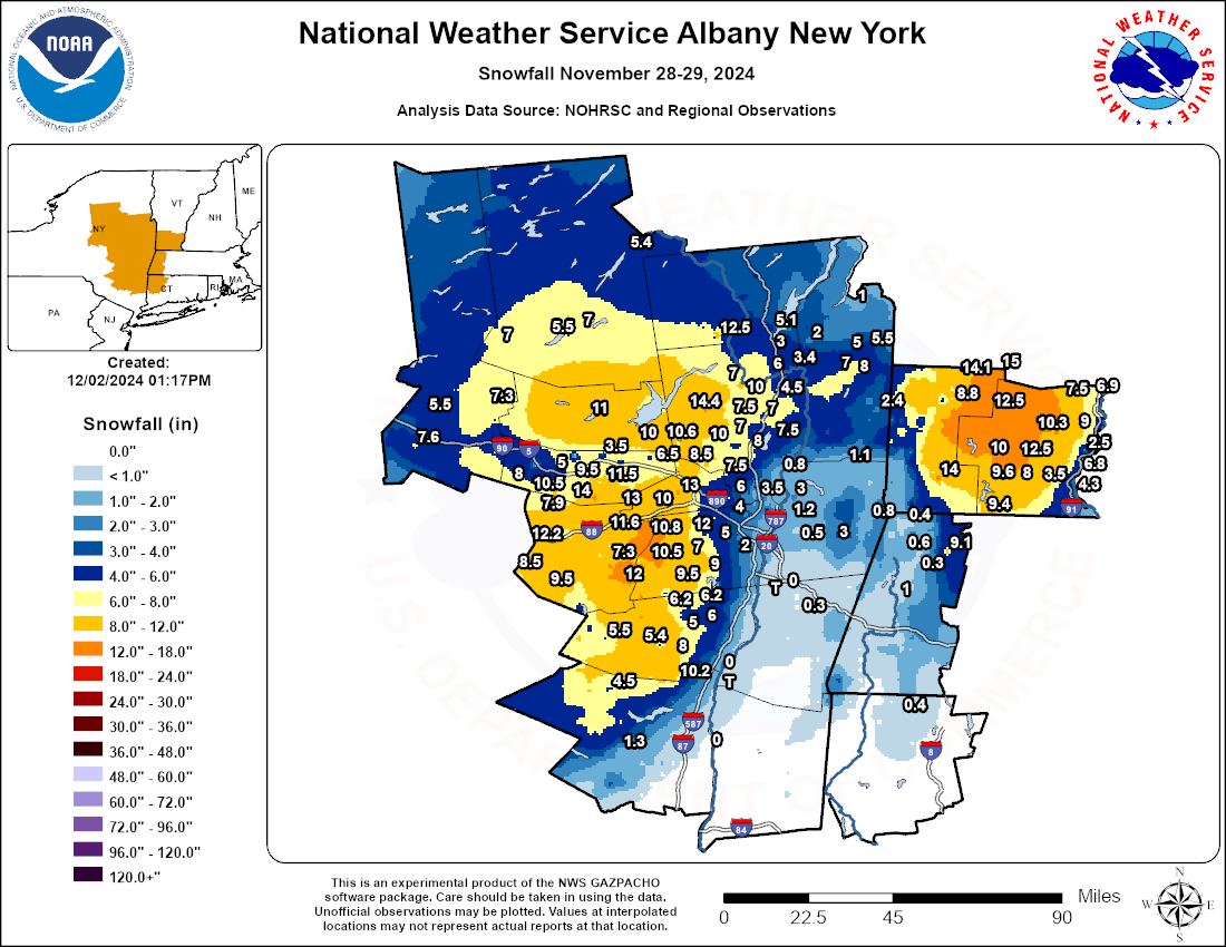 |
| Storm Total Snowfall: November 28-29, 2024 |
Public Information Statement
National Weather Service Albany NY
857 AM EST Fri Nov 29 2024

...LATEST SNOWFALL REPORTS NOVEMBER 28, 2024...

Location                     Amount    Time/Date       Provider

...Massachusetts...

...Berkshire County...
2 NNW Savoy                  9.1 in    1002 PM 11/28
3 SE Pittsfield              1.0 in    0424 AM 11/29

...New York...

...Albany County...
4 ENE Livingstonville        12.0 in   0603 AM 11/29
Altamont                     12.0 in   1000 PM 11/28   Public
2 SSW Duanesburg             10.8 in   0917 PM 11/28
4 NW Westerlo                10.5 in   0527 AM 11/29
3 WNW Westerlo               9.5 in    0243 PM 11/28   Broadcast Media
4 ENE Westerlo               9.0 in    0353 AM 11/29
5 NNE Livingstonville        7.3 in    0510 AM 11/29
2 W Voorheesville            7.0 in    0755 PM 11/28   Public
3 NW Guilderland             6.5 in    1000 PM 11/28   Public
2 WNW Guilderland            5.0 in    0829 PM 11/28   Public
4 E Preston Hollow           5.0 in    0824 PM 11/28   Public
1 NNE Latham                 4.2 in    0500 PM 11/28   Public
1 NW Colonie                 4.0 in    0508 PM 11/28   Trained Spotter
2 NE Colonie                 3.7 in    0400 PM 11/28   ASOS
1 SSE Westmere               3.5 in    0500 PM 11/28
3 WNW Cohoes                 2.8 in    0630 PM 11/28   NWS Employee
Latham 1.8 NW                2.2 in    0700 AM 11/29   COCORAHS
Albany 0.7 SW                2.0 in    0700 AM 11/29   COCORAHS
1 SW Albany                  2.0 in    0820 PM 11/28   NWS Employee
2 W Albany                   2.0 in    0731 PM 11/28
Loudonville 1.2 E            1.3 in    0700 AM 11/29   COCORAHS

...Fulton County...
Gloversville 7nw             11.0 in   0700 AM 11/29   COOP
3 S Broadalbin               10.0 in   0738 PM 11/28   Public

...Greene County...
Elka Park 3.8 ESE            10.2 in   0700 AM 11/29   COCORAHS
2 E Tannersville             8.0 in    0411 AM 11/29
Greenville 0.7 E             6.2 in    0630 AM 11/29   COCORAHS
7 SSE Westerlo               6.2 in    0630 AM 11/29
Freehold 3.4 E               6.0 in    0530 AM 11/29   COCORAHS
Lexington 1.5 N              5.5 in    0700 AM 11/29   COCORAHS
5 SSE Tannersville           5.5 in    0700 AM 11/29
4 NNE Cairo                  5.5 in    0530 AM 11/29
3 N Tannersville             5.4 in    0230 PM 11/28   Public
4 NNW Cairo                  5.0 in    0347 PM 11/28

...Hamilton County...
Hoffmeister 2.4 WNW          7.0 in    0800 AM 11/29   COCORAHS
Lake Pleasant 2.3 WSW        7.0 in    0655 AM 11/29   COCORAHS
2 E Piseco                   5.5 in    0832 PM 11/28   Public
Indian Lake                  5.4 in    0720 AM 11/29   COOP

...Herkimer County...
3 SSW Frankfort              7.6 in    0455 PM 11/28   Public
5 NNW Dolgeville             7.3 in    0515 AM 11/29
Schuyler 3.3 NE              5.5 in    0700 AM 11/29   COCORAHS

...Montgomery County...
Charleston Four Co           14.0 in   1030 PM 11/28   Public
3 ESE Ames                   10.5 in   0830 PM 11/28   Public
Hessville 1.8 WSW            8.0 in    0800 AM 11/29   COCORAHS
1 NW Amsterdam               6.8 in    0516 PM 11/28
4 SE Hagaman                 6.5 in    0248 PM 11/28   Public
2 E Canajoharie              5.0 in    0340 AM 11/29
1 N Fonda                    3.5 in    0518 PM 11/28
Fort Plain 0.2 SE            1.5 in    0700 AM 11/29   COCORAHS

...Rensselaer County...
3 ENE Waterford              3.0 in    0731 PM 11/28   Public
Troy 2.1 NNE                 1.8 in    0700 AM 11/29   COCORAHS
Troy 2.6 N                   1.3 in    0730 AM 11/29   COCORAHS
2 NE Troy                    1.2 in    0415 PM 11/28   NWS Employee

...Saratoga County...
5 W Porter Corners           14.4 in   0910 PM 11/28
4 WNW Rock City Falls        10.6 in   0715 AM 11/29   COCORAHS
2 N Rock City Falls          10.0 in   0700 PM 11/28   Public
1 S Corinth                  10.0 in   0433 PM 11/28
3 NW Burnt Hills             8.5 in    0428 PM 11/28
Ballston Spa 2.9 ESE         8.0 in    0815 AM 11/29   COCORAHS
Milton 5.9 NNW               7.9 in    0700 AM 11/29   COCORAHS
Greenfield Center 1.6 W      7.5 in    0700 AM 11/29   COCORAHS
2 N Round Lake               7.5 in    0922 PM 11/28
4 ENE Saratoga Springs       7.5 in    0400 PM 11/28   NWS Employee
1 ENE Milton                 7.0 in    0700 PM 11/28   Public
Porter Corners               7.0 in    0656 PM 11/28   Public
6 NNE Saratoga Springs       7.0 in    0300 PM 11/28   Trained Spotter
3 SSW Porter Corners         6.8 in    0700 AM 11/29
3 SSE Ballston Spa           6.7 in    0430 PM 11/28   NWS Employee
2 N Round Lake               6.6 in    0410 PM 11/28   Public
2 W Galway                   6.5 in    0911 PM 11/28
2 N Clifton Park             6.0 in    0400 PM 11/28   Trained Spotter
4 NNE Saratoga Springs       5.5 in    0409 PM 11/28
4 NW Gansevoort              4.5 in    0404 AM 11/29
2 ESE Clifton Park           3.5 in    0600 PM 11/28   NWS Employee
3 SSE Clifton Park           1.0 in    0600 AM 11/29
Clifton Park 2.7 S           1.0 in    0600 AM 11/29   COCORAHS

...Schenectady County...
3 ESE Mariaville             13.0 in   0814 PM 11/28
Delanson 2ne                 11.0 in   0700 AM 11/29   COOP
1 N Delanson                 10.0 in   0420 PM 11/28
2 ESE Duanesburg             9.6 in    0600 PM 11/28   NWS Employee
1 SE Niskayuna               6.4 in    0400 PM 11/28   NWS Employee
1 SSE Alplaus                5.5 in    0330 PM 11/28   NWS Employee
1 NE Schenectady             4.3 in    0445 PM 11/28   NWS Employee

...Schoharie County...
Esperance                    13.0 in   1120 PM 11/28   Public
4 SSW Delanson               12.5 in   0726 PM 11/28   Public
1 WSW Richmondville          12.2 in   0435 AM 11/29
5 WNW Jefferson              10.5 in   0510 PM 11/28
2 SE Jefferson               9.5 in    0538 PM 11/28
2 SW Cobleskill              6.5 in    0724 PM 11/28   Public

...Warren County...
7 SSE Johnsburg              12.5 in   0733 PM 11/28   Public
Lake Luzerne 3 S             7.0 in    0600 AM 11/29   COOP
1 N Corinth                  7.0 in    0520 AM 11/29
2 WSW West Glens Falls       6.0 in    0400 PM 11/28   Public
2 N Lake George Villag       5.1 in    0621 PM 11/28   NWS Employee
Glens Falls                  3.4 in    0930 PM 11/28   Trained Spotter
1 N Lake George Villag       3.0 in    0600 AM 11/29

...Washington County...
6 NE Argyle                  7.0 in    0509 AM 11/29
5 WSW Granville              5.5 in    0554 AM 11/29
6 SE Fort Ann                5.0 in    0502 AM 11/29
Salem 2.3 SSE                2.4 in    0600 AM 11/29   COCORAHS
4 W Fort Ann                 2.0 in    0950 PM 11/28   Public

...Vermont...

...Bennington County...
5 NNW Londonderry            15.0 in   0647 AM 11/29
Peru                         14.1 in   0600 AM 11/29   COOP
2 WSW Woodford State Park    14.0 in   0503 PM 11/28   Broadcast Media
6 S Peru                     12.5 in   0450 PM 11/28   Public

...Windham County...
East Dover 1.8 N             12.5 in   0705 AM 11/29   COCORAHS
5 SSW West Wardsboro         10.0 in   0710 PM 11/28   Public
1 WNW Wilmington             9.6 in    0543 AM 11/29
Wilmington 0.6 WNW           9.6 in    0543 AM 11/29   COCORAHS
3 ESE Readsboro              9.4 in    0800 PM 11/28   Trained Spotter
4 W Westminster              9.0 in    0737 PM 11/28   Public
4 SW Newfane                 8.0 in    0845 PM 11/28   Public
Townshend                    8.0 in    0830 PM 11/28   Trained Spotter
4 NNE Saxtons River          7.5 in    0759 PM 11/28   Public
Rockingham 1.1 NNE           6.9 in    0700 AM 11/29   COCORAHS
East Dummerston 0.5 NE       6.8 in    0800 AM 11/29   COCORAHS
2 SSE Brattleboro            4.3 in    0700 AM 11/29
Brattleboro 0.7 S            4.3 in    0700 AM 11/29   COCORAHS
Radar
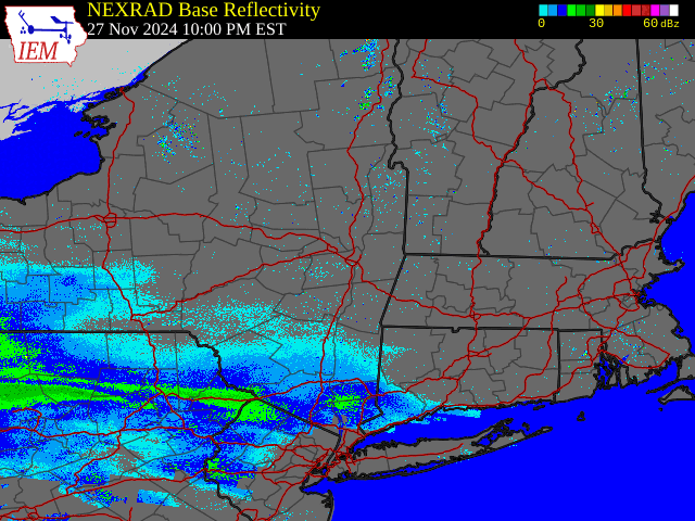 |
| Regional Radar Loop valid 10:00 pm November 27 to 10:00 pm EDT November 28, 2024 |
Environment
250 hPa Analysis
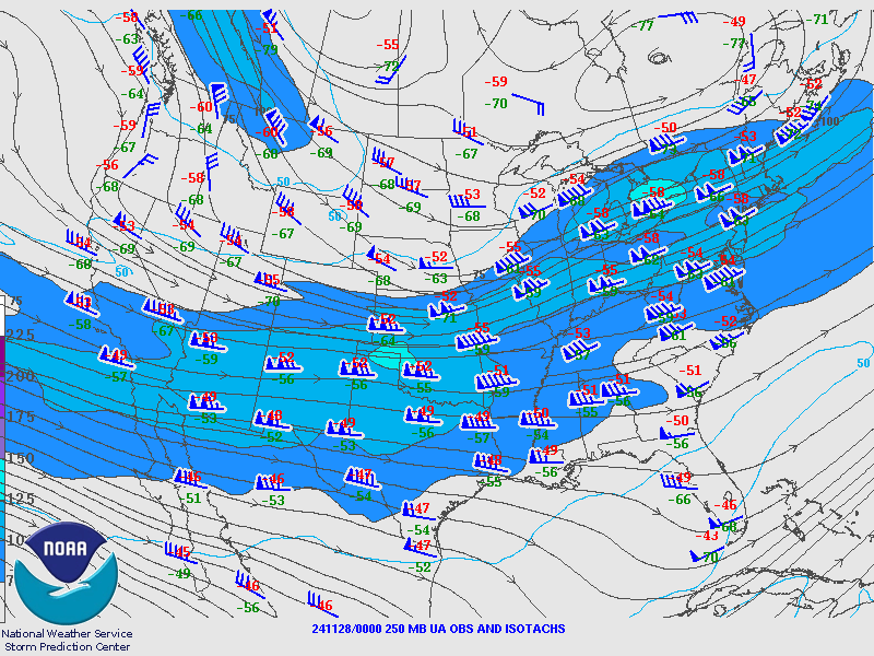 |
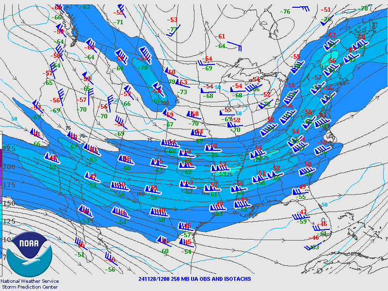 |
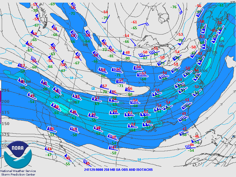 |
| Valid 00z November 28, 2024 | Valid 12z November 28, 2024 | Valid 00z November 29, 2024 |
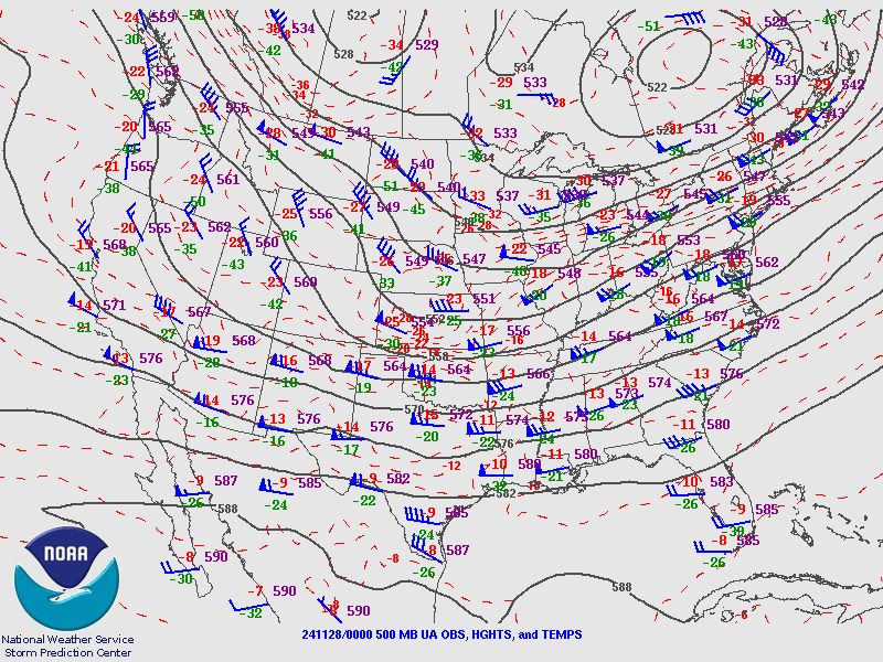
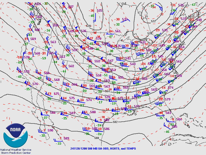
500 hPa Analysis
 |
 |
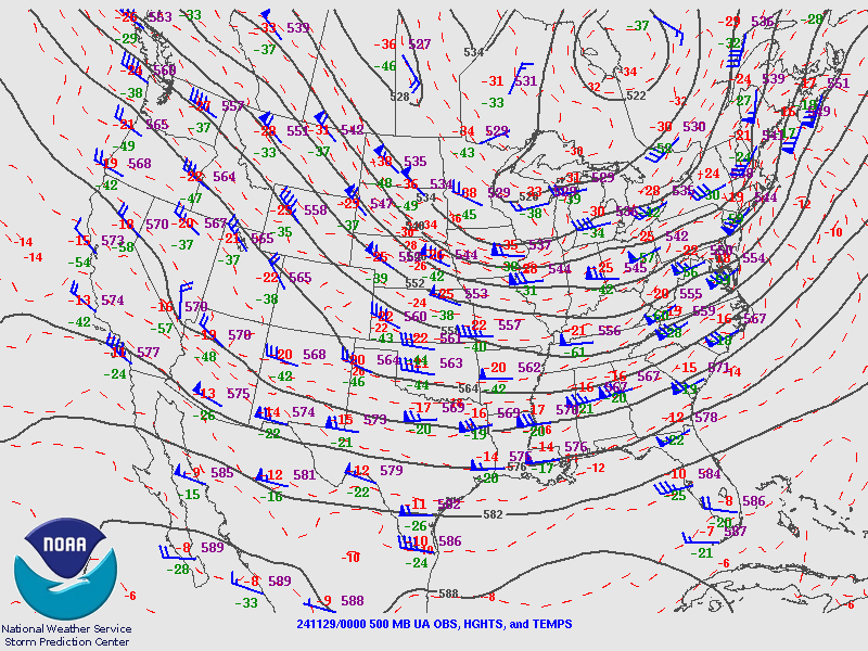 |
| Valid 00z November 28, 2024 | Valid 12z November 28, 2024 | Valid 00z November 29, 2024 |
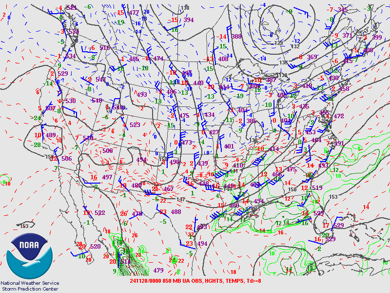
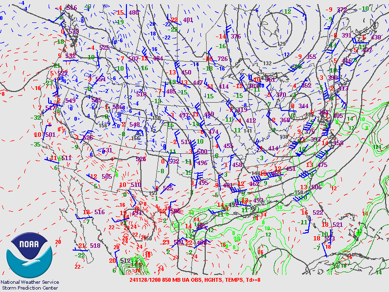
850 hPa Analysis
 |
 |
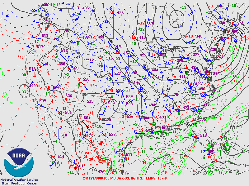 |
| Valid 00z November 28, 2024 | Valid 12z November 28, 2024 | Valid 00z November 29, 2024 |
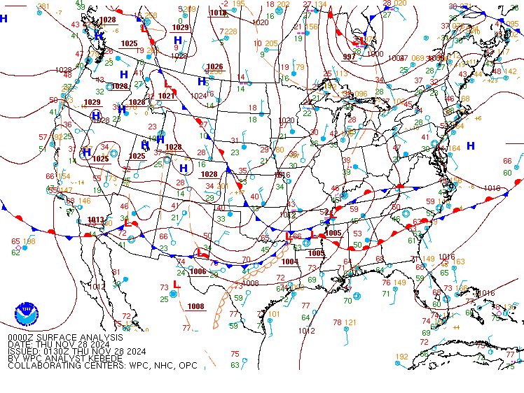
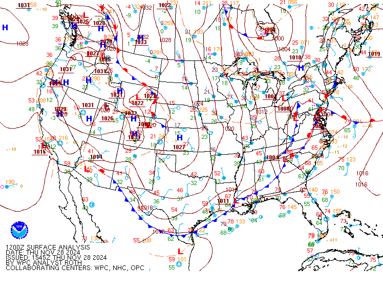
Surface Analysis
 |
 |
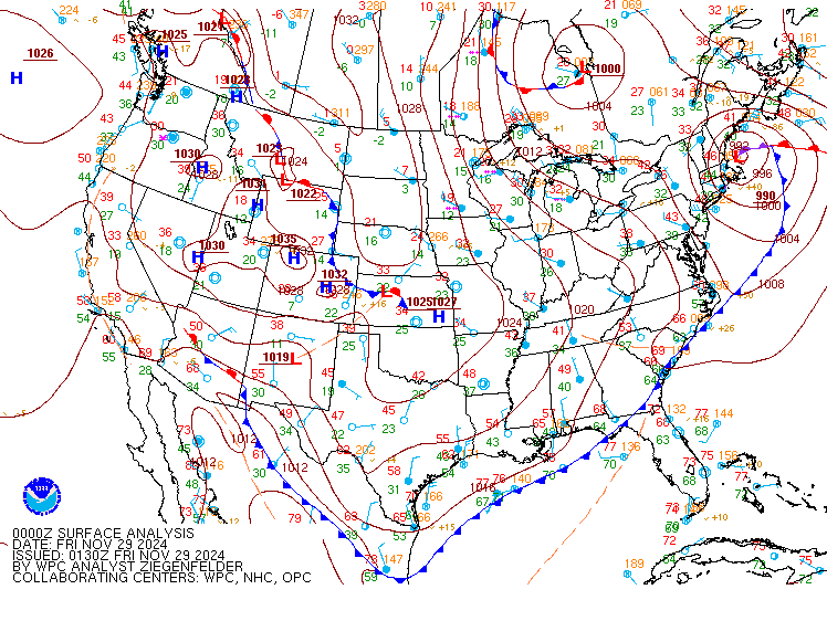 |
| Valid 00z November 28, 2024 | Valid 12z November 28, 2024 | Valid 00z November 29, 2024 |
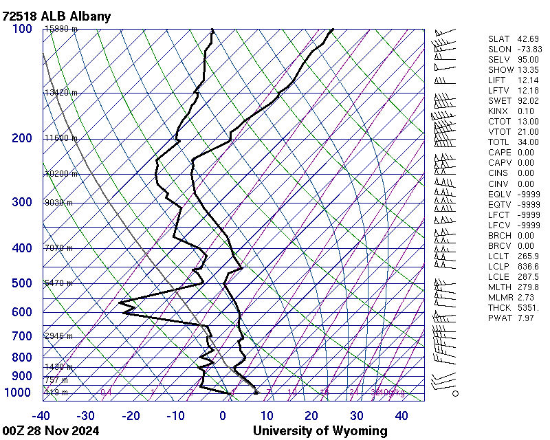
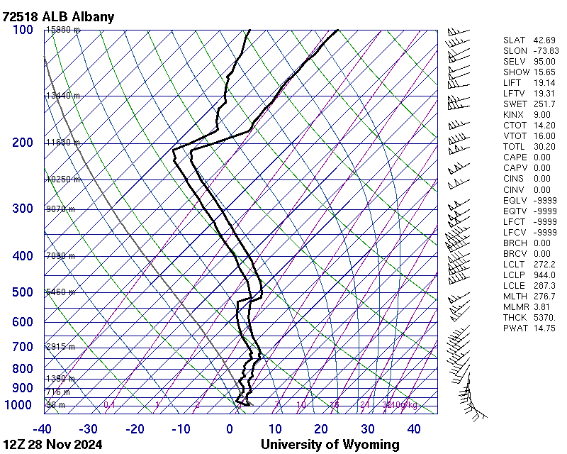
Upper Air Soundings
 |
 |
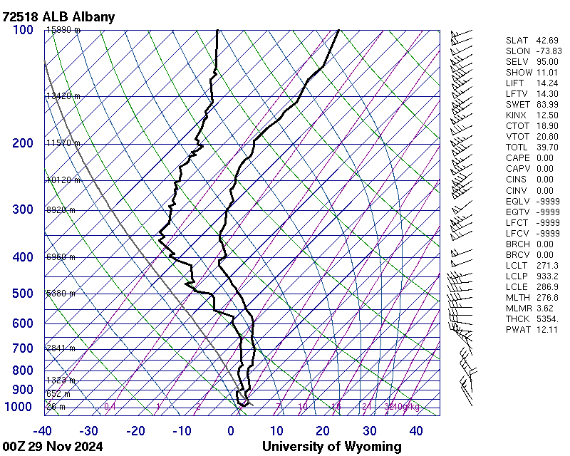 |
| Valid 00z November 28, 2024 (courtesy of University of Wyoming) | Valid 12z November 28, 2024 (courtesy of University of Wyoming) | Valid 00z November 29, 2024 (courtesy of University of Wyoming) |
 |
Media use of NWS Web News Stories is encouraged! Please acknowledge the NWS as the source of any news information accessed from this site. |
|

