Overview
A mesoscale convective vortex (MCV) tracked across New York state on July 16, 2024. This was related to a larger Mesoscale Convective System (MCS) that developed well upstream in the Midwest the day before leading to widespread storm damage in the Chicago Metro area. After the MCV tracked off Lake Ontario, a line of organized and severe thunderstorms quickly developed and tracked through Central NY leading to widespread wind damage and tornadoes. With favorable hot and humid conditions in place over eastern NY, the organized severe line of storms continued its eastward track during the afternoon and evening hours. Widespread and, in some areas, considerable wind damage was observed along with embedded tornadoes through the western/southern Adirondacks, Mohawk Valley, Upper Hudson Valley, Capital District, and southern VT with the strongest and most intense storms occurring along and north of Interstate 90. The highest recorded wind gust occurred at the NYS Mesonet at Glens Falls of 87 mph, which is the highest recorded wind gust by any mesonet site on record at the time. Scattered to numerous power outages occurred as a result of the storms.
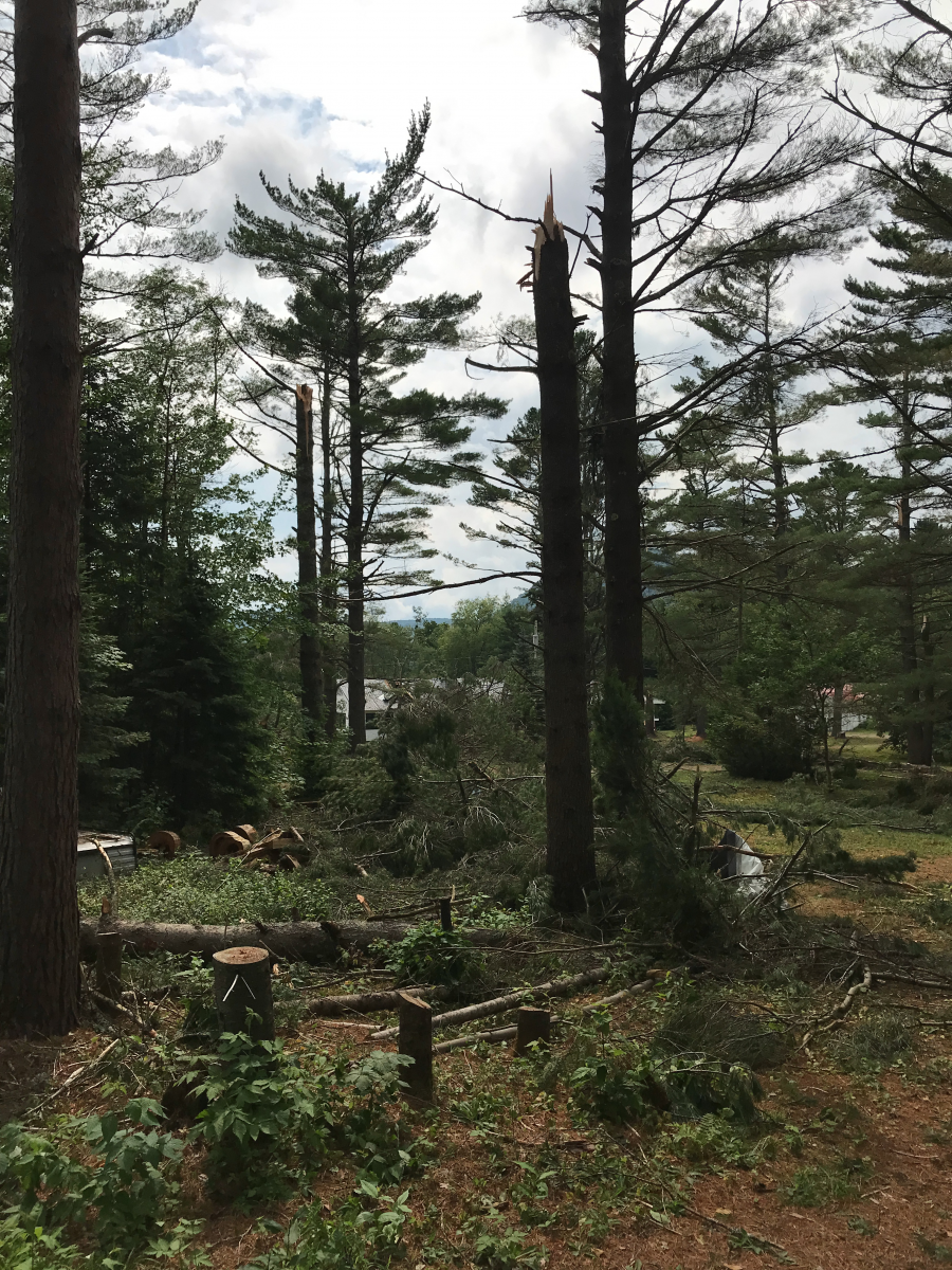
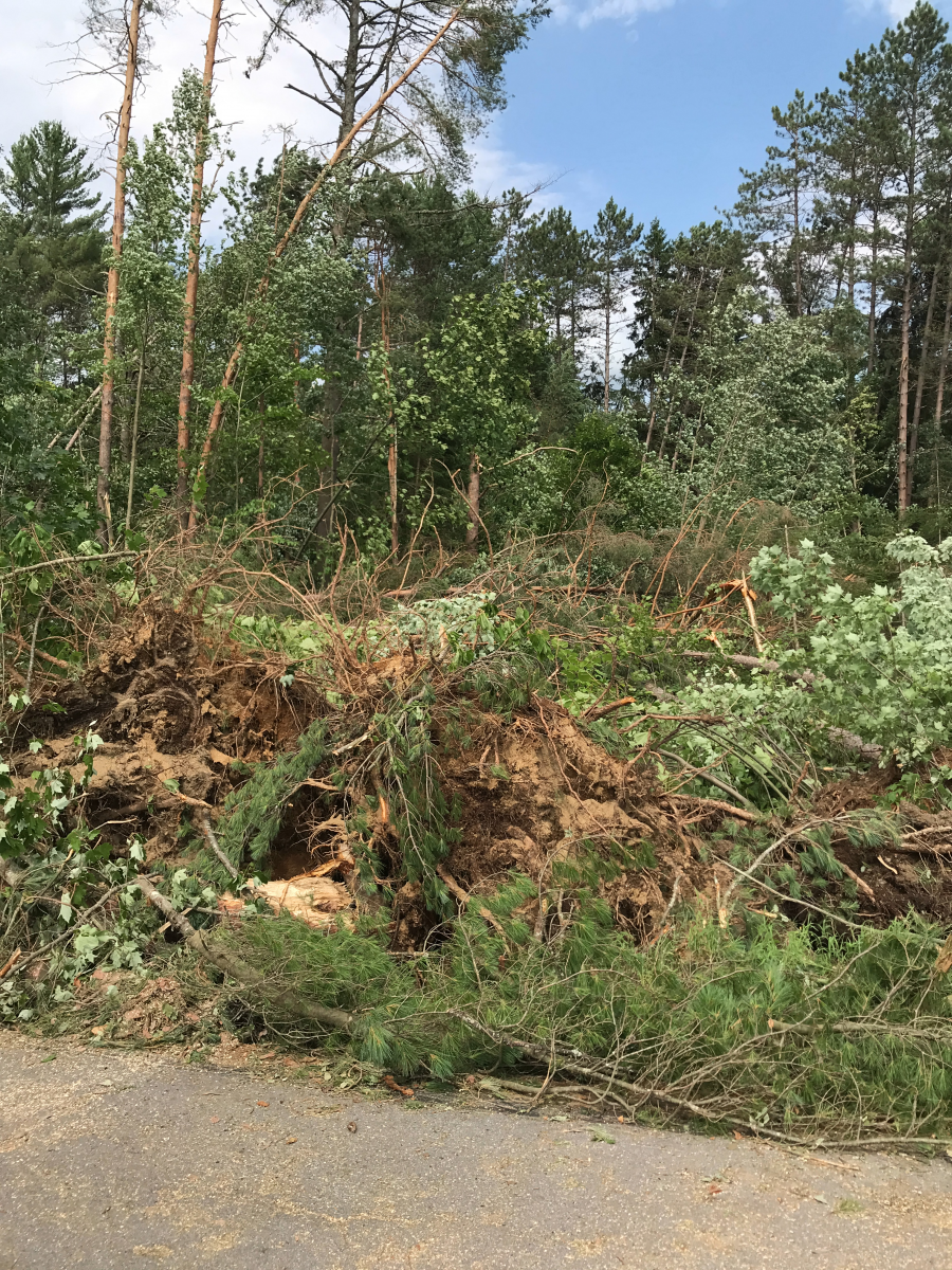
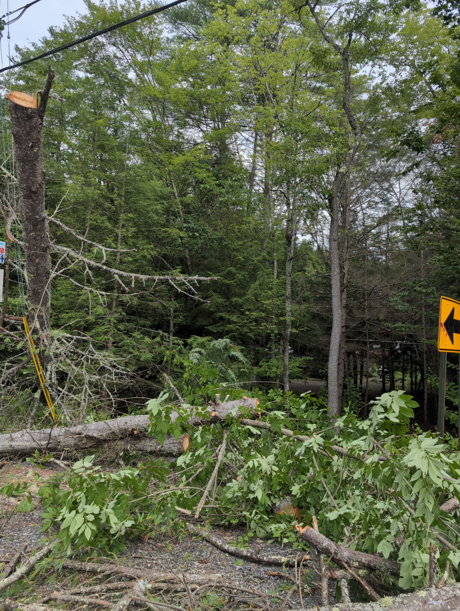
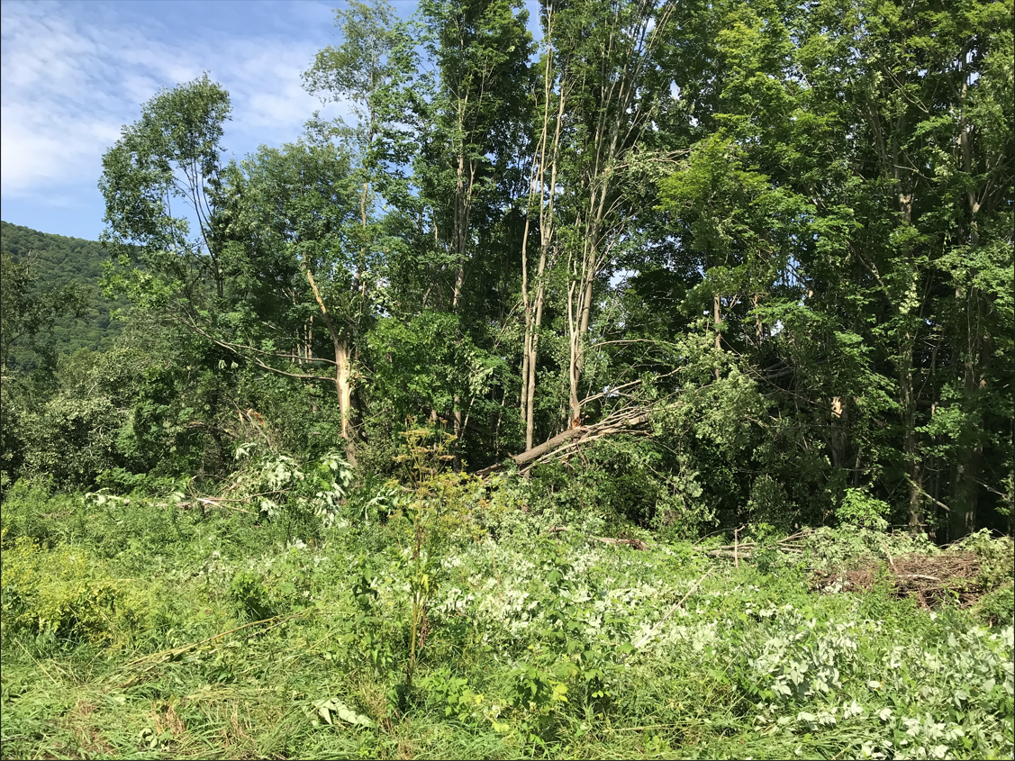
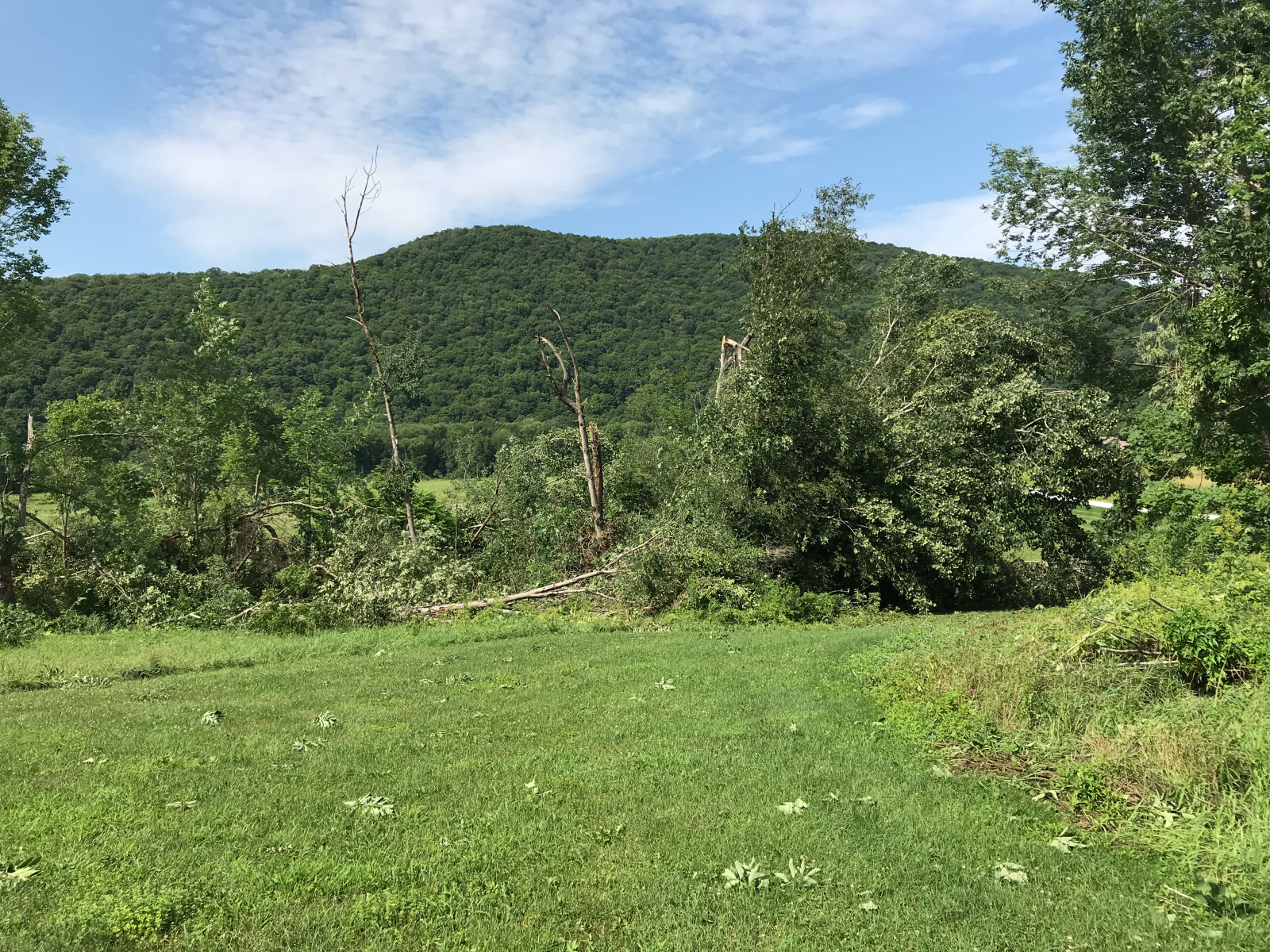
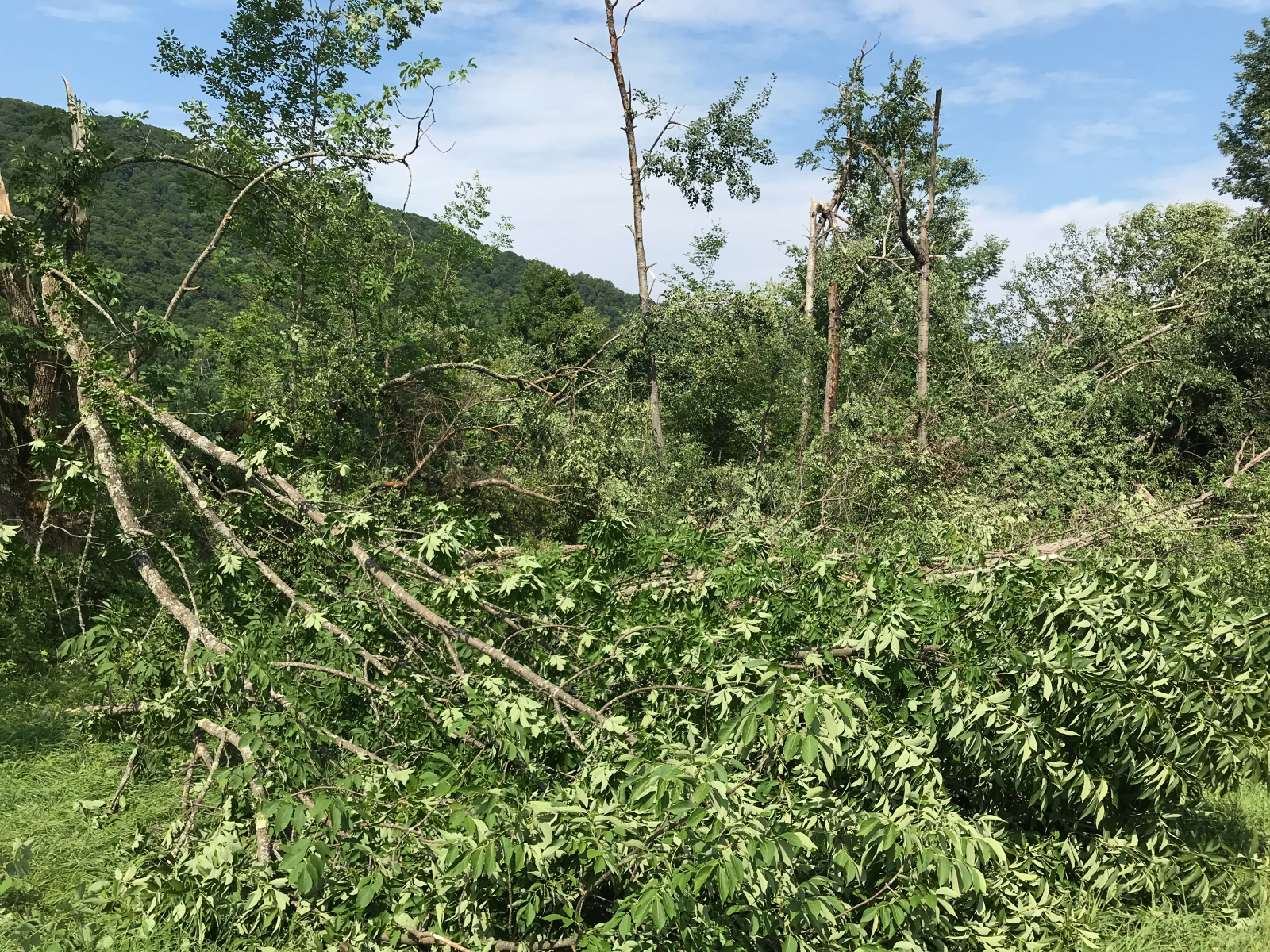
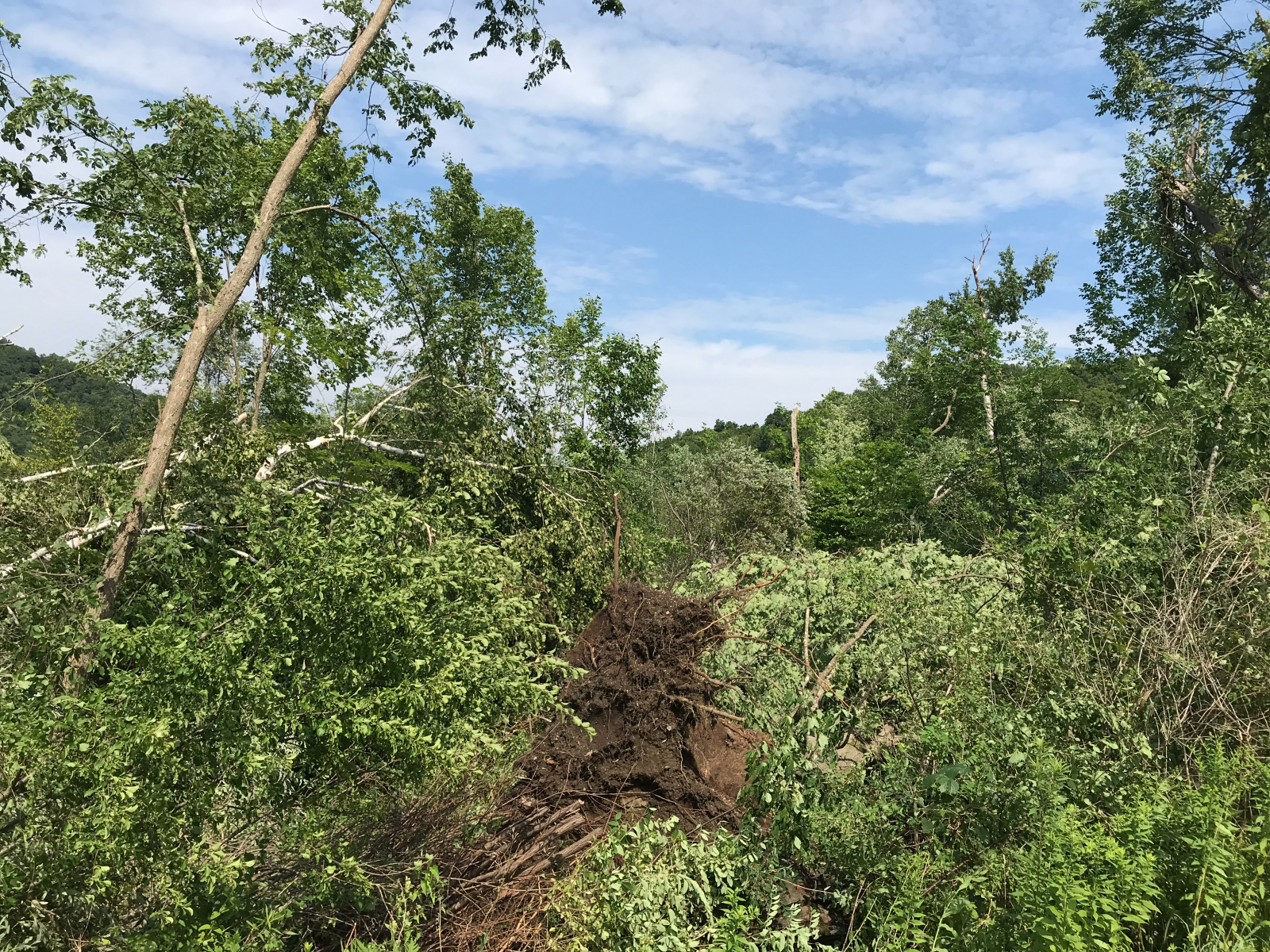
National Weather Service Storm Surveys, with some being assisted by other state authorities, concluded seven tornado touchdowns. Six of these tornadoes were rated EF-1 with estimated peak winds between 90 and 110 mph. These tornadoes occurred in the Town of Ohio (Herkimer County), Little Moose Lake/Limekiln Lake (Hamilton County), the West Branch of the Sacandaga River/West River Road (Hamilton County), Oxbow Lake (Hamilton County), Wilcox Lake Wild Forest (Hamilton/Warren County), and the Town of Day (Saratoga County). One EF-0 tornado touched down near The Glen in central Warren County with estimated peak winds of 85 mph.
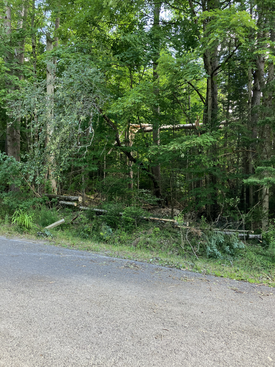
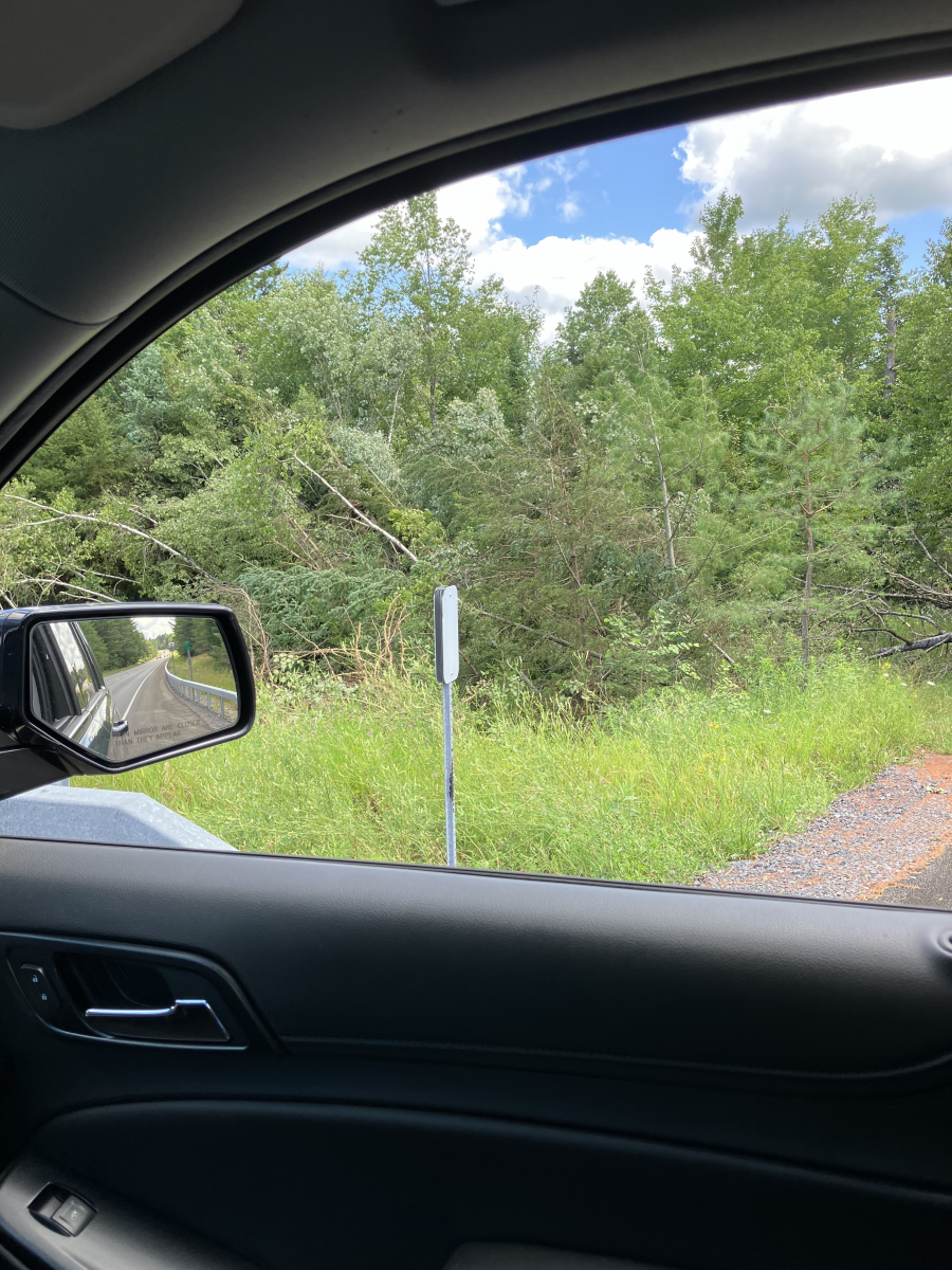
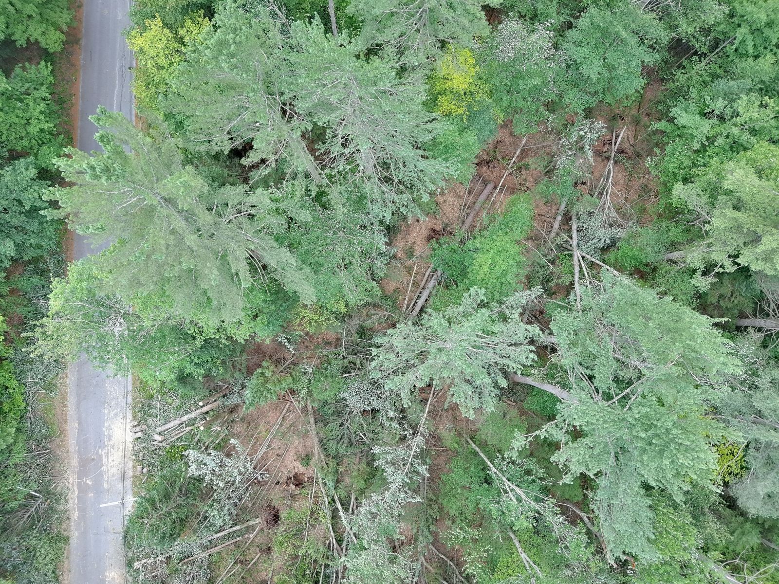
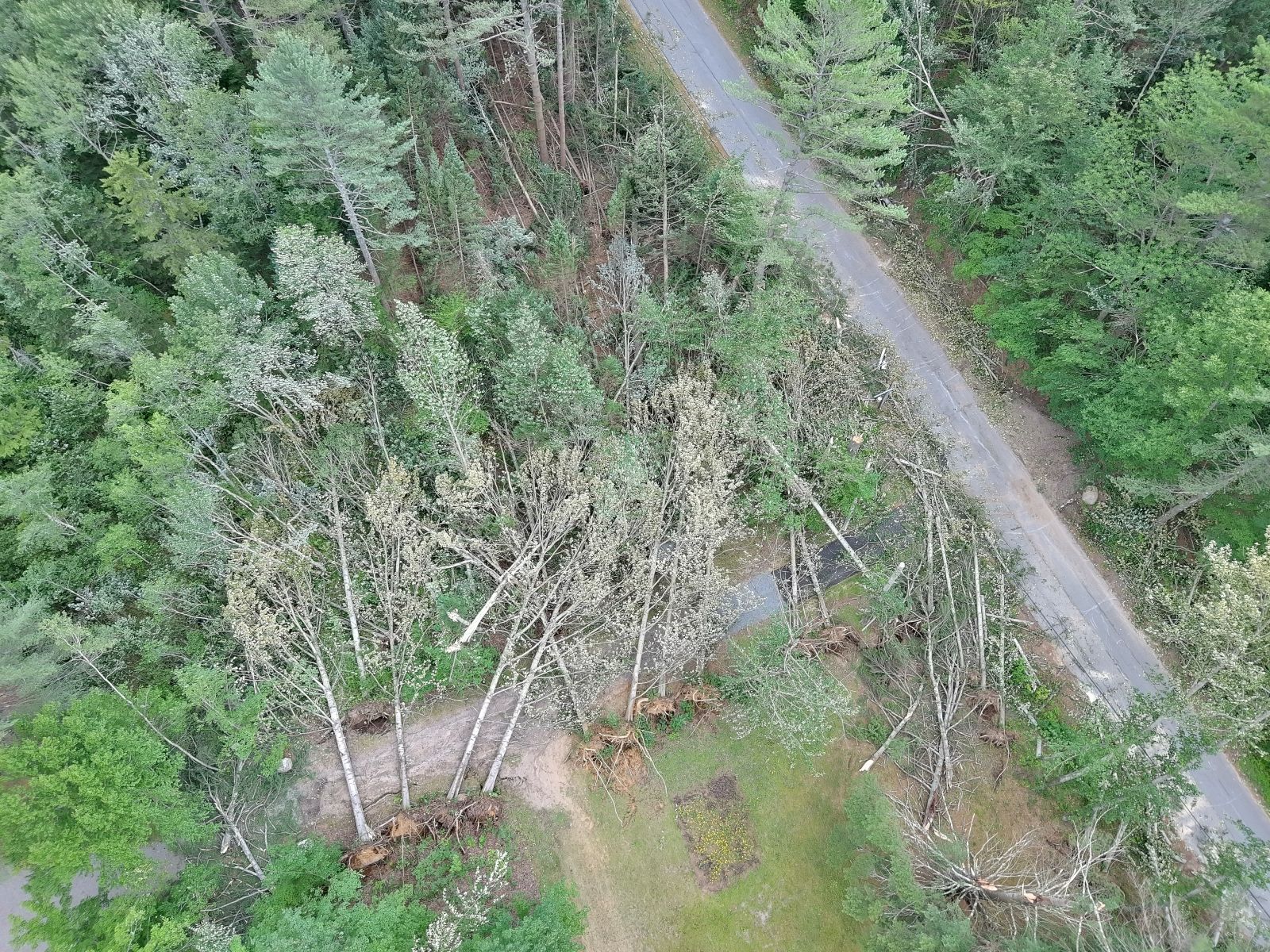
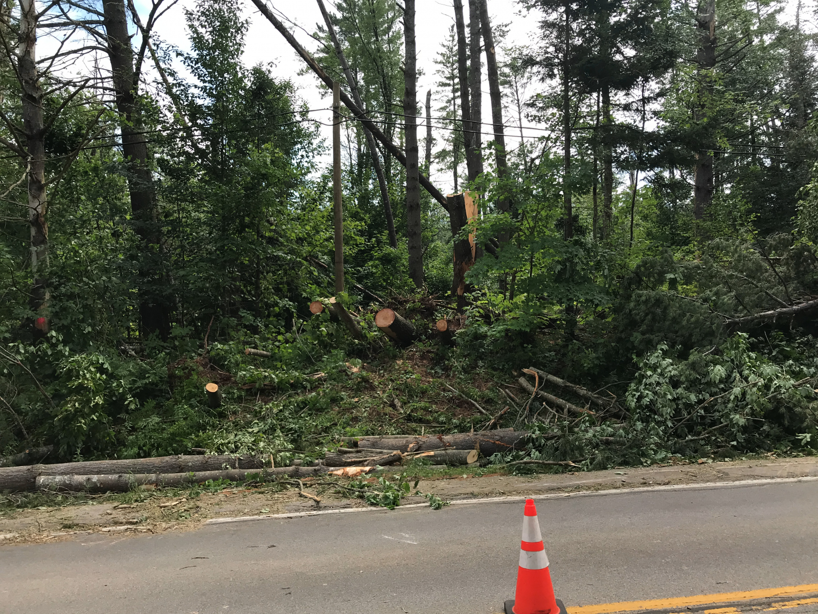
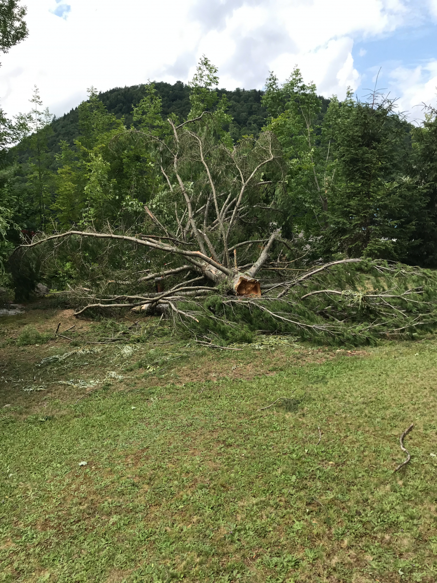
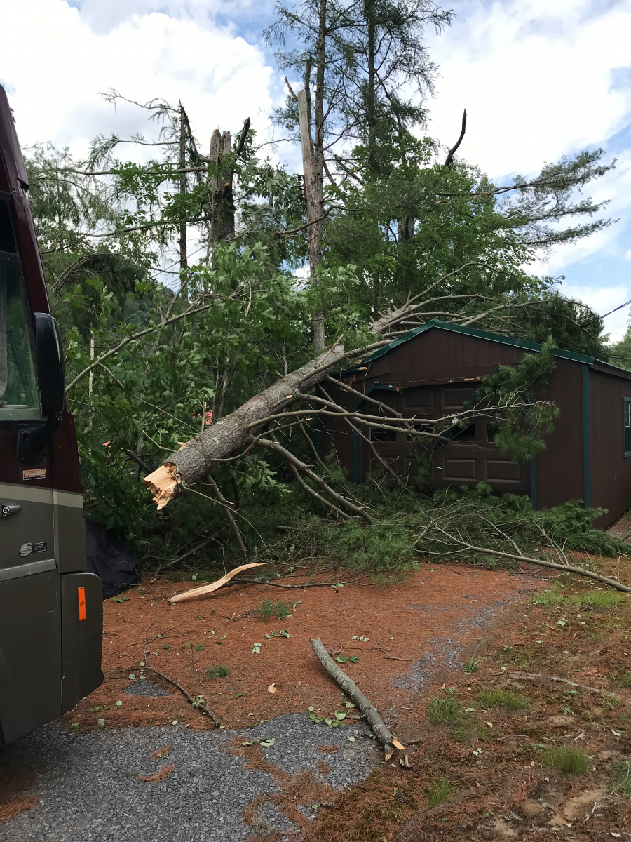
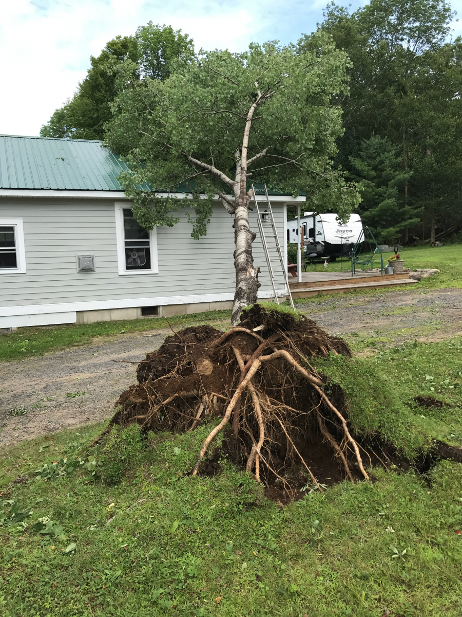
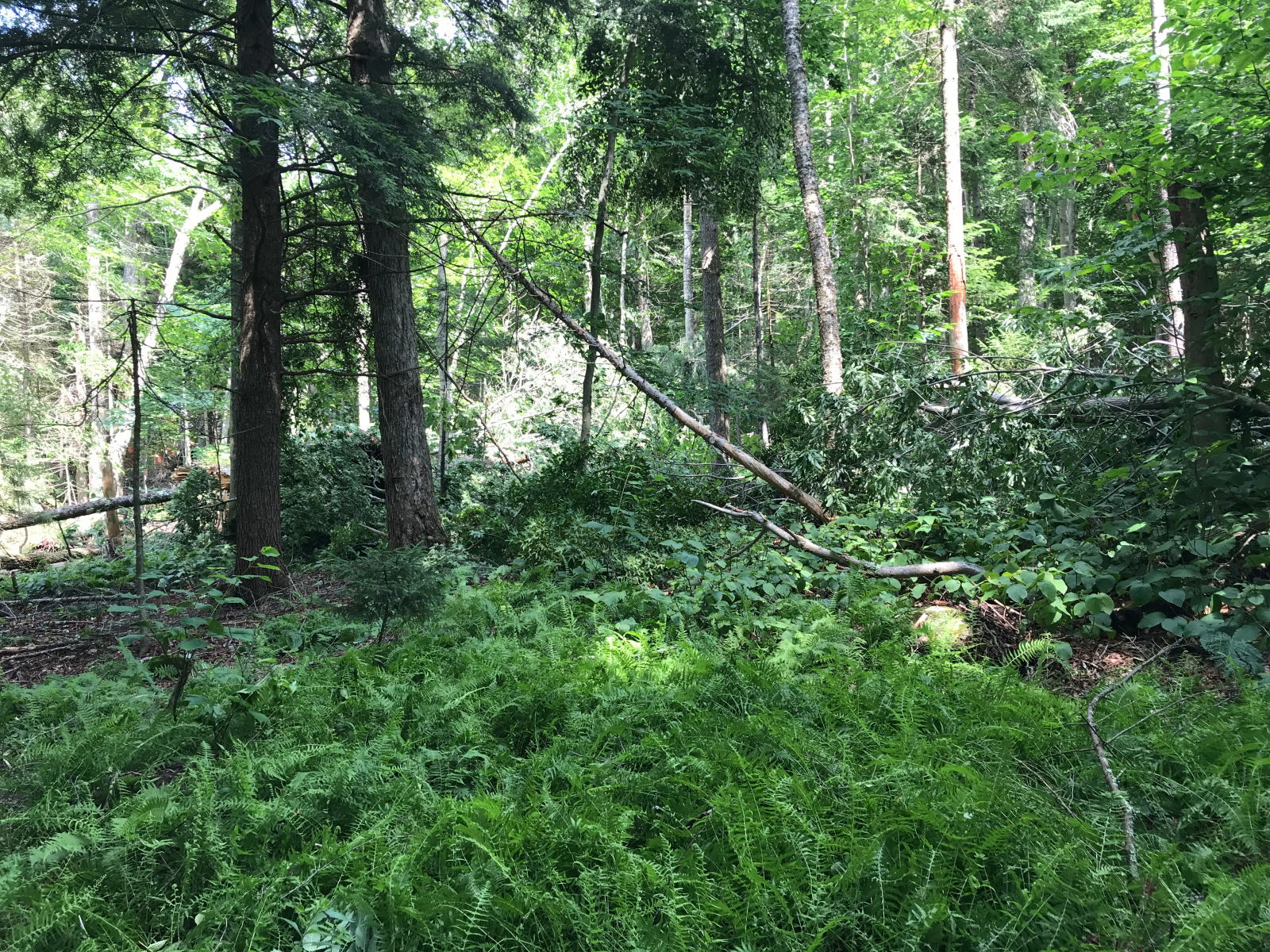
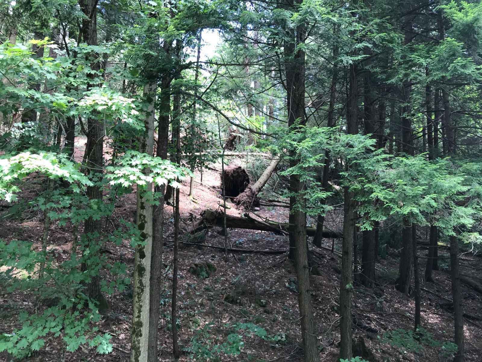
In addition to tornadoes, two microbursts, determined through remote damage assessment using drone footage and satellite imagery, were noted in Warren County. Both brought large areas of extensive tree damage with hundreds of hardwood trees being uprooted and snapped. The first was noted in western Warren County along and east of Stewart Creek with the second around Bear Point at the Tongue Mountain Range that extends into Lake George. A third microburst occurred near North Rupert, VT which snapped and uprooted over 2 dozen trees.
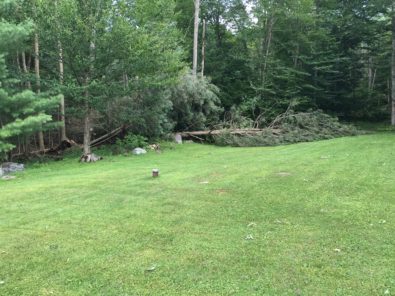
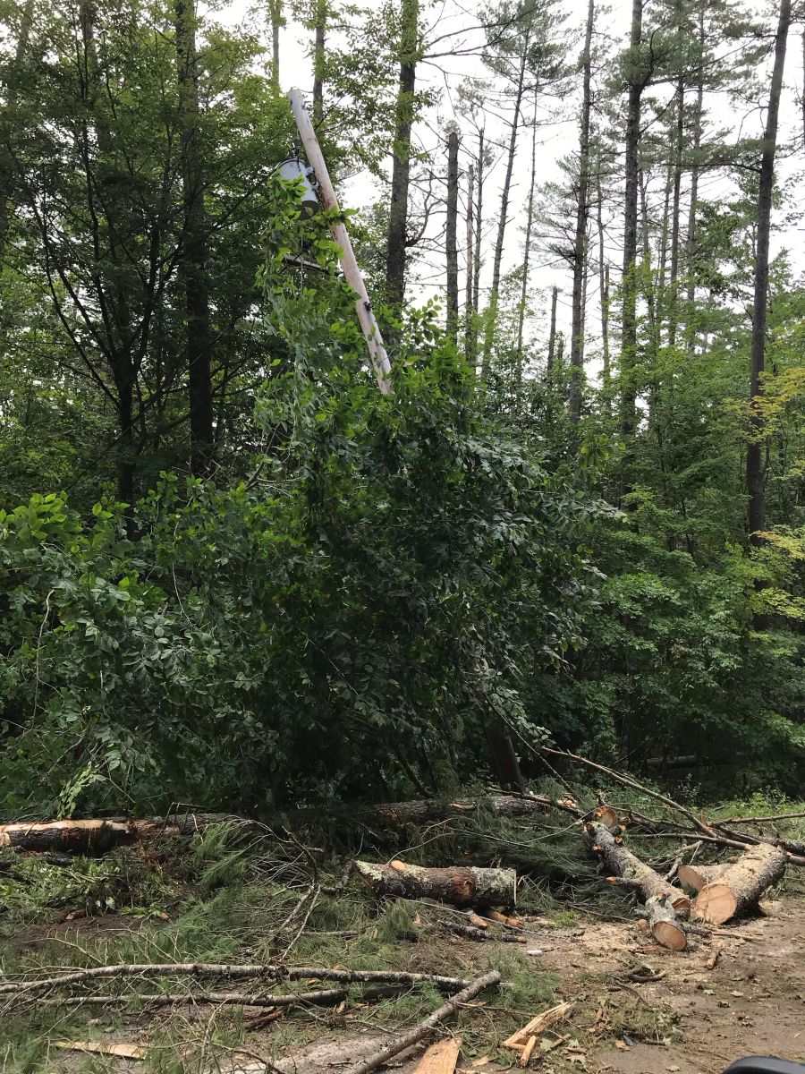
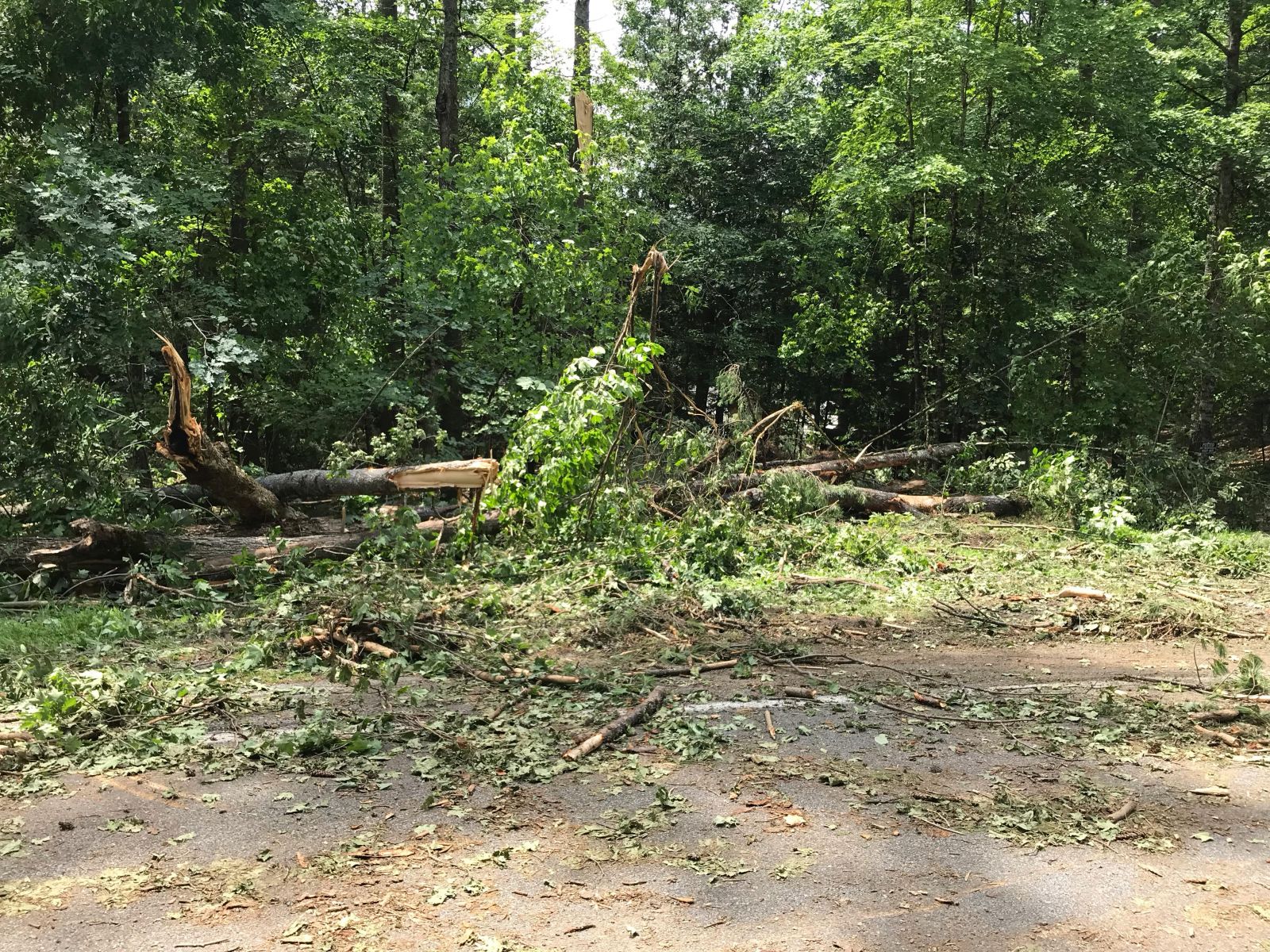
By far, the majority of the widespread damage that was observed was a result of straight line winds. Some power outages lasted for multiple days and some area roads were also impassable for days.
States of Emergency were declared for multiple municipalities. New York Governor Kathy Hochul also declared a state of emergency for all of New York State following all of the severe thunderstorms that impacted the state over the past week. The governor also requested a Federal Emergency Declaration following this severe weather event which included the counties of Hamilton, Herkimer, Montgomery, Saratoga and Warren.
The National Weather Service in Albany, NY would like to thank the New York State Police, New York State Division of Homeland Security and Emergency Services (DHSES) Office of Emergency Management Region III, our trained Skywarn Spotters, CoCoRaHS Observers and others who assisted us evaluate the considerable damage across eastern New York and western New England. We sincerely appreciate all the pictures and emails sent to us. Your efforts helped us immensely with our storm surveys and evaluation of this remarkable event.
Tornadoes:
|
Tornado - Ohio, NY
Track Map 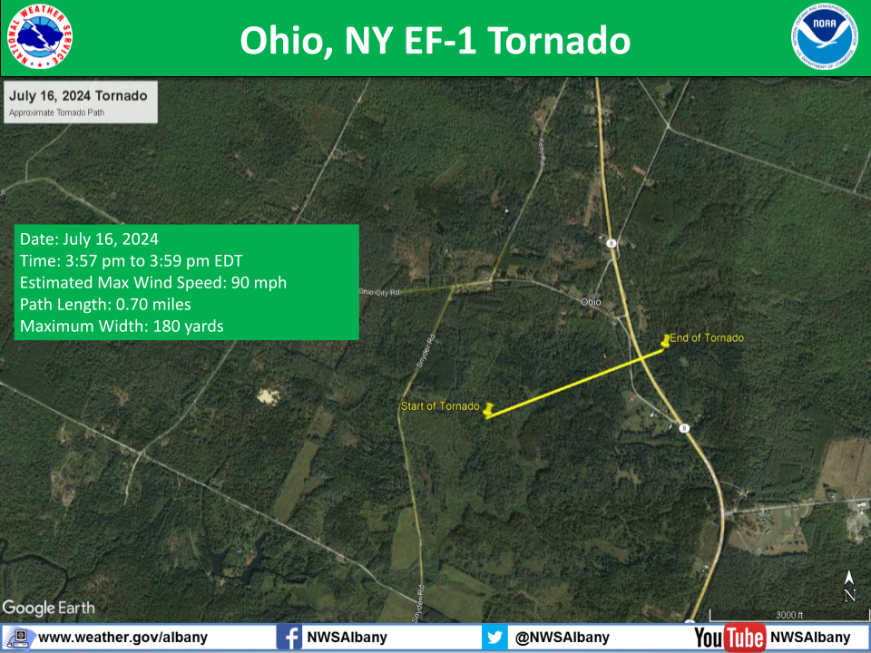 |
||||||||||||||||
|
Tornado - near Limekiln Lake, NY
Track Map 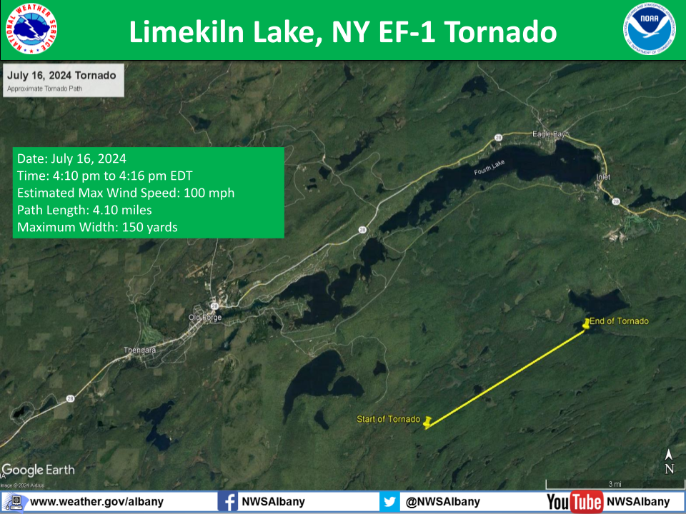 |
||||||||||||||||
|
Tornado - near Wells, NY
Track Map 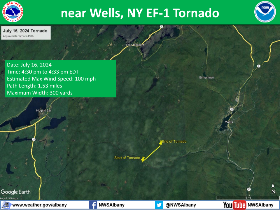 |
||||||||||||||||
|
Tornado - Oxbow Lake, NY
Track Map 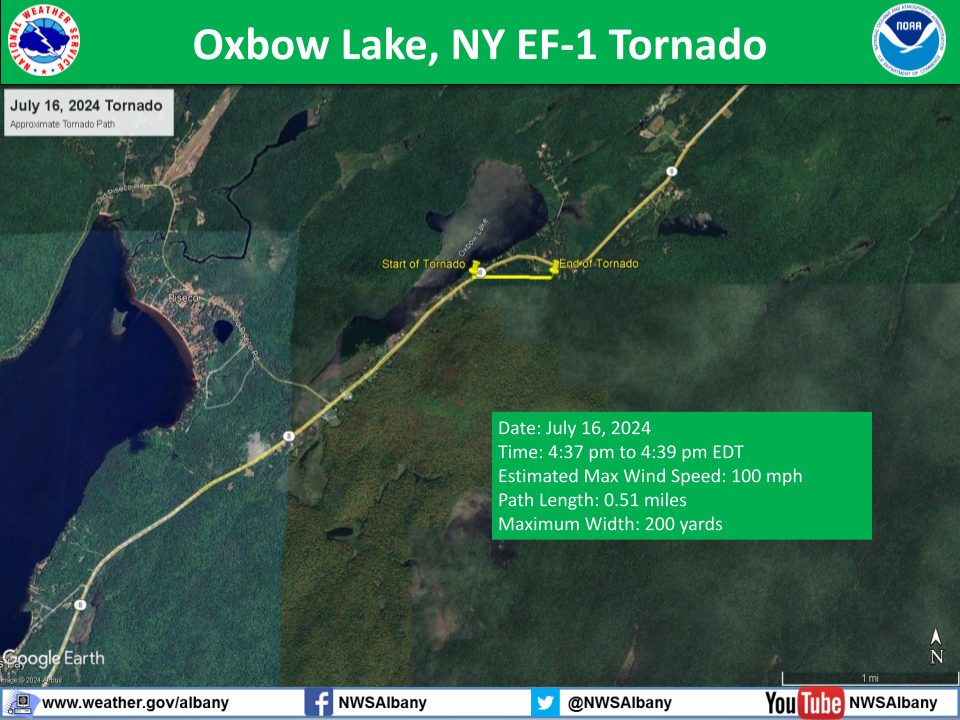 |
||||||||||||||||
|
Tornado - near Wilcox Lake Wild Forest, NY
Track Map 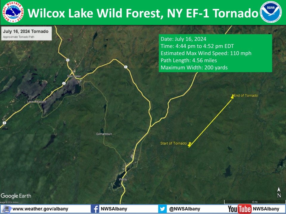 |
||||||||||||||||
|
Tornado - Great Sacandaga Lake, NY
Track Map 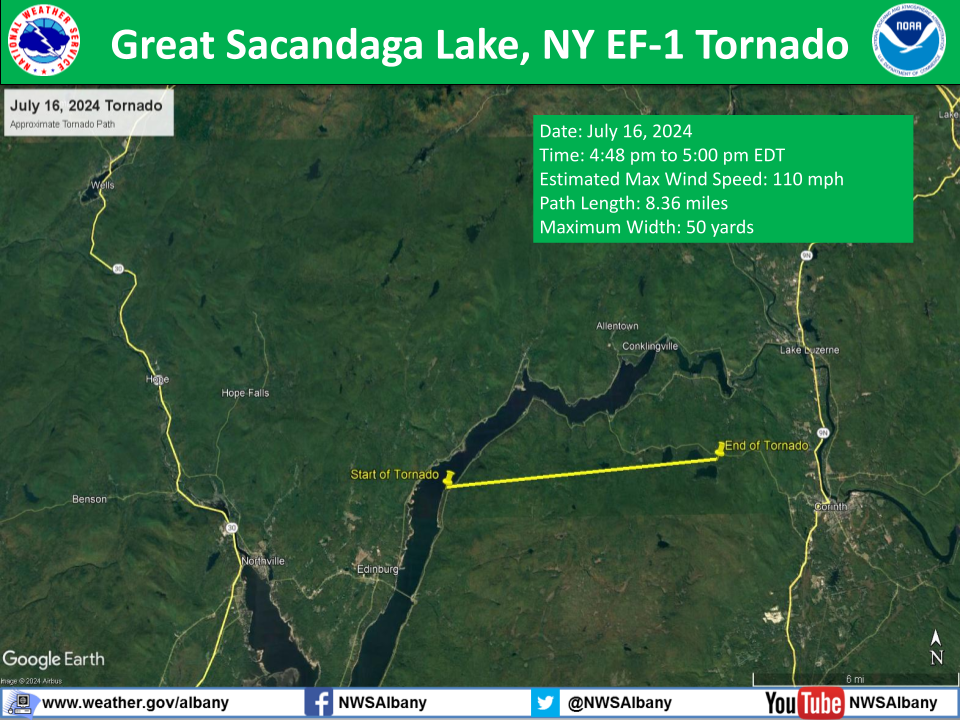 |
||||||||||||||||
|
Tornado - near The Glen, NY
Track Map 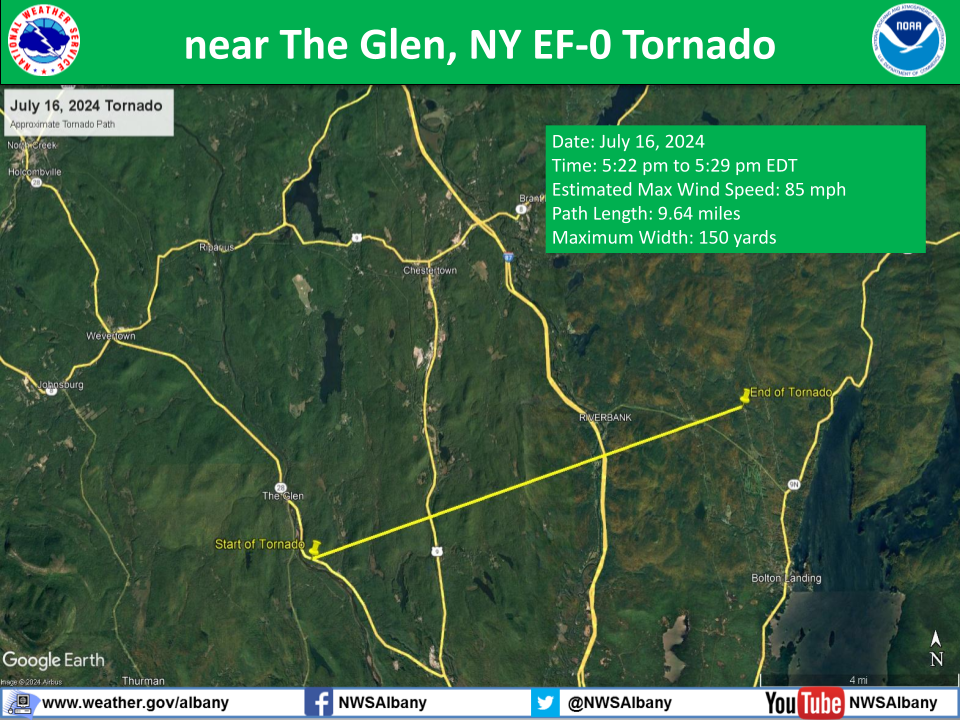 |
||||||||||||||||
The Enhanced Fujita (EF) Scale classifies tornadoes into the following categories:
| EF0 Weak 65-85 mph |
EF1 Moderate 86-110 mph |
EF2 Significant 111-135 mph |
EF3 Severe 136-165 mph |
EF4 Extreme 166-200 mph |
EF5 Catastrophic 200+ mph |
 |
|||||
Significant Wind Damage:
|
Microburst - Stewart Creek, NY
Track Map 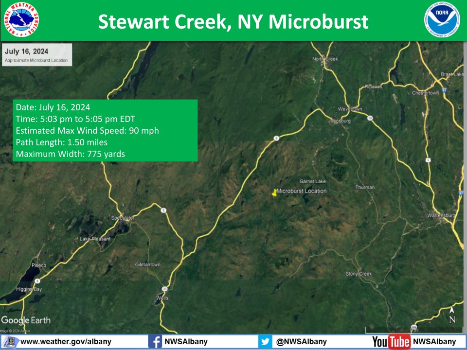 |
||||||||||||||
|
Microburst - Bear Point, Bolton, NY
Track Map 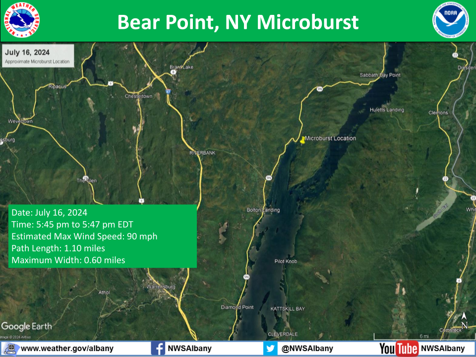 |
||||||||||||||
|
Microburst - North Rupert, VT
Track Map 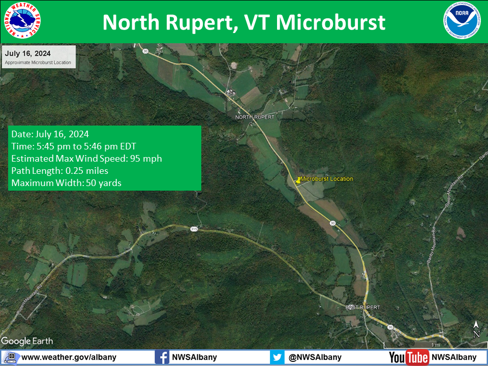 |
||||||||||||||
Photos & Video
 |
 |
 |
 |
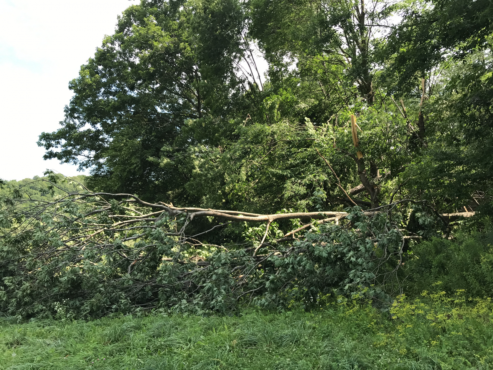
| Tree Damage near Ohio, NY from the EF-1 Tornado on July 16, 2024 (NWS Storm Survey) |
Tree Damage near Ohio, NY from the EF-1 Tornado on July 16, 2024 (NWS Storm Survey) |
Tree Damage near Ohio, NY from the EF-1 Tornado on July 16, 2024 (NWS Storm Survey) |
Tree Damage near Ohio, NY from the EF-1 Tornado on July 16, 2024 (NWS Storm Survey) |
 |
 |
 |
 |
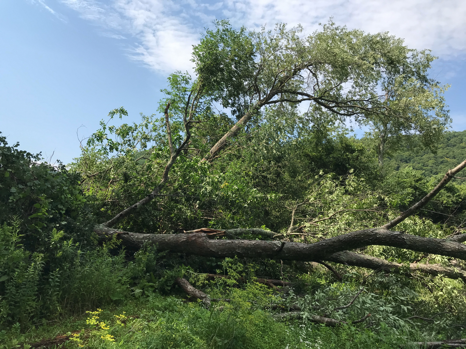
| Tree Damage near Oxbow Lake, NY from the EF-1 Tornado on July 16, 2024 (Image Courtesy of the New York State Police and New York State Office of Emergency Management Region III) |
Tree Damage near Oxbow Lake, NY from the EF-1 Tornado on July 16, 2024 (Image Courtesy of the New York State Police and New York State Office of Emergency Management Region III) |
Tree Damage near Oxbow Lake, NY from the EF-1 Tornado on July 16, 2024 (NWS Storm Survey) |
Tree Damage near Oxbow Lake, NY from the EF-1 Tornado on July 16, 2024 (NWS Storm Survey) |
 |
 |
 |
 |
| Tree and Structural Damage near Oxbow Lake, NY from the EF-1 Tornado on July 16, 2024 (NWS Storm Survey) |
Tree and Structural Damage near Oxbow Lake, NY from the EF-1 Tornado on July 16, 2024 (NWS Storm Survey) |
Tree Damage near Oxbow Lake, NY from the EF-1 Tornado on July 16, 2024 (NWS Storm Survey) |
Tree Damage near Oxbow Lake, NY from the EF-1 Tornado on July 16, 2024 (NWS Storm Survey) |
 |
 |
.JPG) |
.JPG) |
| Tree Damage near Oxbow Lake, NY from the EF-1 Tornado on July 16, 2024 (NWS Storm Survey) |
Tree Damage near Oxbow Lake, NY from the EF-1 Tornado on July 16, 2024 (NWS Storm Survey) |
Tree Damage near Wells, NY from the EF-1 Tornado on July 16, 2024 (Image Courtesy of the New York State Police and New York State Office of Emergency Management Region III) |
Tree Damage near Wells, NY from the EF-1 Tornado on July 16, 2024 (Image Courtesy of the New York State Police and New York State Office of Emergency Management Region III) |
 |
 |
 |
 |
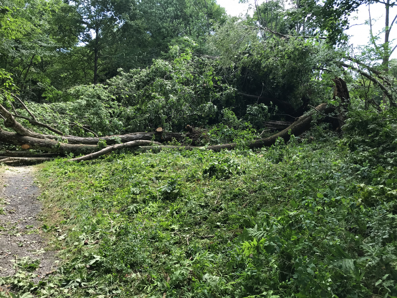
| Tree Damage near Great Sacandaga Lake, NY from the EF-1 Tornado on July 16, 2024 (NWS Storm Survey) |
Tree Damage near Chestertown, NY from the EF-0 Tornado on July 16, 2024 (NWS Storm Survey) |
Tree Damage near Chestertown, NY from the EF-0 Tornado on July 16, 2024 (NWS Storm Survey) |
Tree Damage near Chestertown, NY from the EF-0 Tornado on July 16, 2024 (NWS Storm Survey) |
 |
 |
 |
 |
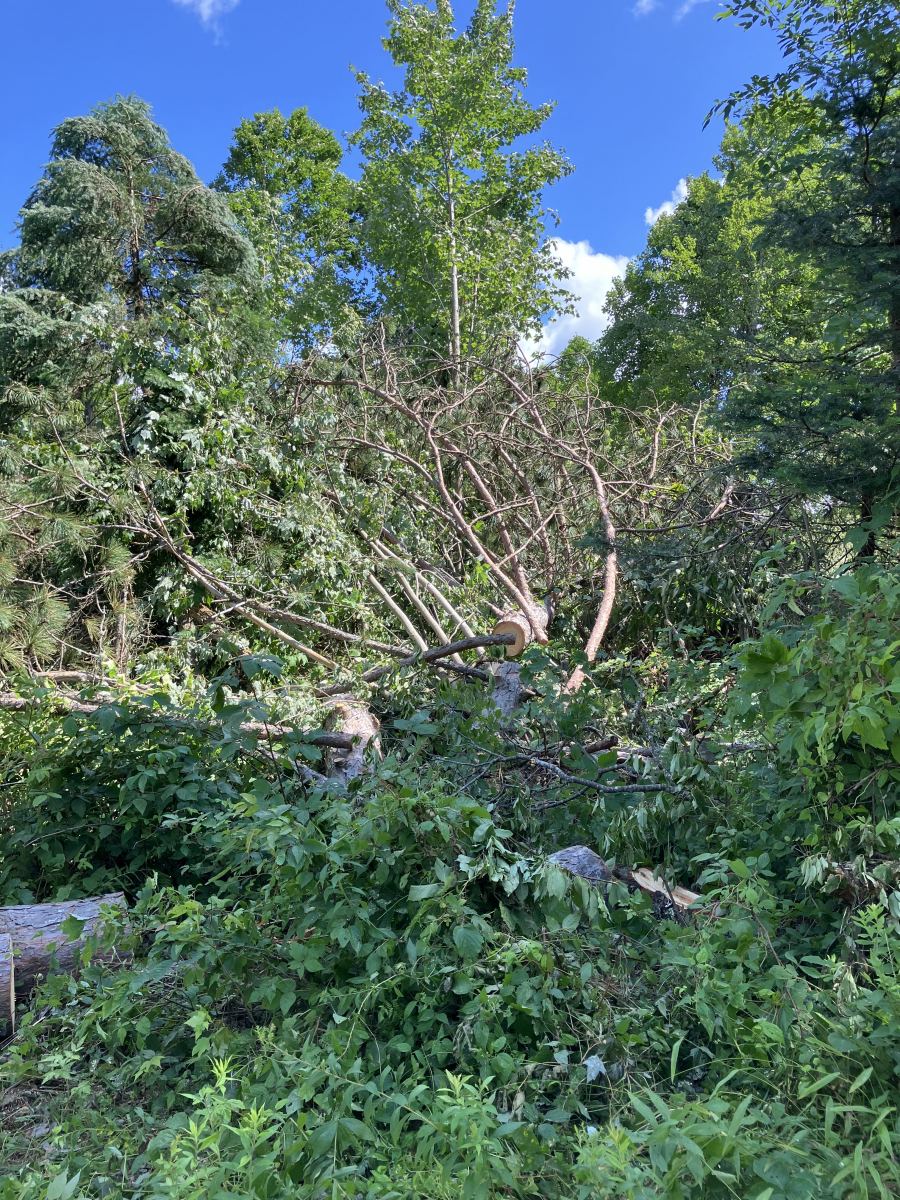
| Tree Damage near North Rupert, VT from a Microburst on July 16, 2024 (NWS Storm Survey) | Tree Damage near North Rupert, VT from a Microburst on July 16, 2024 (NWS Storm Survey) | Tree Damage near North Rupert, VT from a Microburst on July 16, 2024 (NWS Storm Survey) | Tree Damage near North Rupert, VT from a Microburst on July 16, 2024 (NWS Storm Survey) |
 |
 |
 |
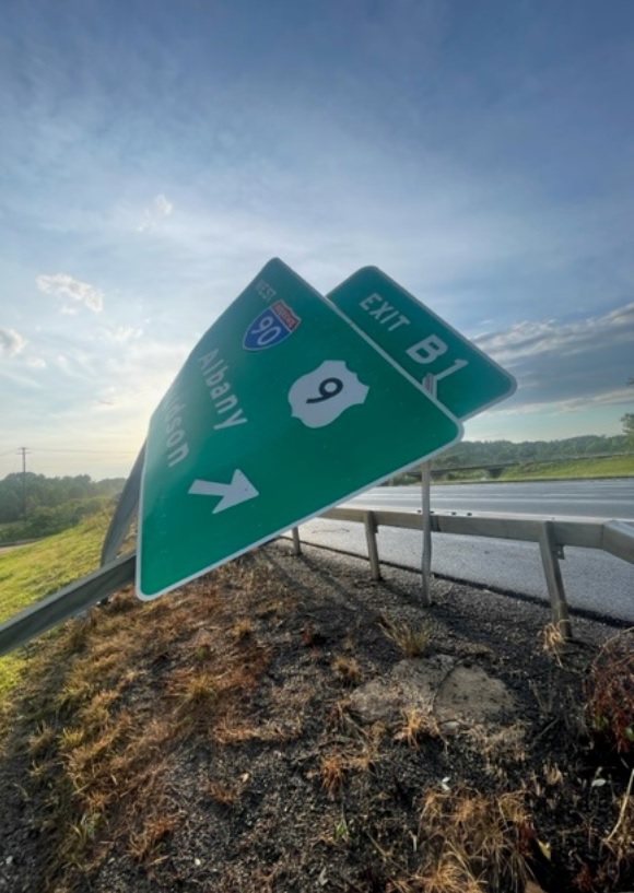 |
| Tree Damage near North Rupert, VT from a Microburst on July 16, 2024 (NWS Storm Survey) | Tree Damage near North Rupert, VT from a Microburst on July 16, 2024 (NWS Storm Survey) | Tree Damage near North Rupert, VT from a Microburst on July 16, 2024 (NWS Storm Survey) | Bent Road Sign on the Berkshire Spur in Rensselaer County, NY (Image Courtesy of the New York State Thruway Authority) |
Radar
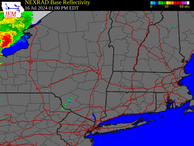 |
| Regional Radar Loop valid 1:00 pm to 10:00 pm July 16, 2024 |
Storm Reports
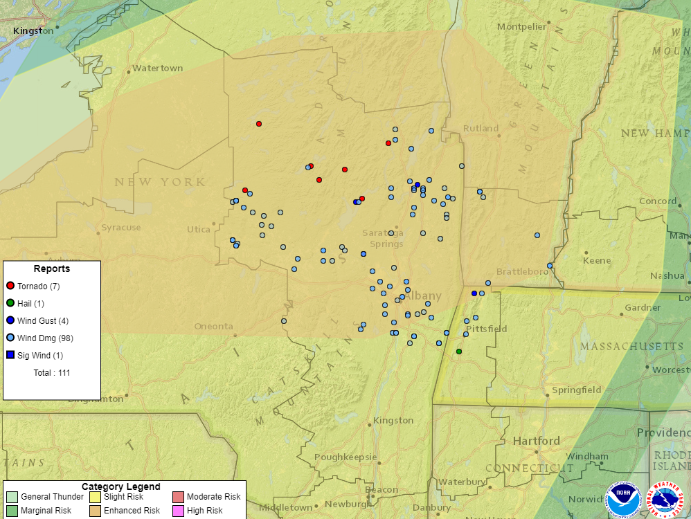 |
| Wind, Tornado and Hail Local Storm Reports from July 16, 2024 across the NWS Albany County Warning Area (Note: severe weather reports outside of our county warning area are not plotted on this map. All reports are preliminary and subject to change pending final review of the events and publication in NWS Storm Data) |
Preliminary Local Storm Report...Summary
National Weather Service Albany NY
1034 PM EDT Fri Jul 19 2024
..TIME... ...EVENT... ...CITY LOCATION... ...LAT.LON...
..DATE... ....MAG.... ..COUNTY LOCATION..ST.. ...SOURCE....
..REMARKS..
0347 PM Tstm Wnd Dmg 1 N Poland 43.24N 75.06W
07/16/2024 Herkimer NY Trained Spotter
Corrects previous tstm wnd dmg report from 1
N Poland. Several trees and limbs down on
South Shore Road just south of King Arthurs
Court. Time estimated from radar.
0349 PM Tstm Wnd Dmg 1 NNE Poland 43.24N 75.06W
07/16/2024 Herkimer NY Trained Spotter
Tree down on Buck Hill Road in Cold Brook.
Time estimated from radar.
0353 PM Tstm Wnd Dmg 2 WNW Poland 43.23N 75.09W
07/16/2024 Herkimer NY Trained Spotter
Tree down blocking one lane of NYS Rte 28
near the town of Russia Highway Garage. Time
estimated from radar.
0353 PM Tstm Wnd Dmg 1 NE Newport 43.20N 75.00W
07/16/2024 Herkimer NY Trained Spotter
Report of multiple trees down along
Newport-Grey Road and NYS rte 28, time
estimated from radar.
0353 PM Tstm Wnd Dmg 2 SSW Frankfort 43.01N 75.09W
07/16/2024 Herkimer NY Trained Spotter
Corrects previous tstm wnd dmg report from 2
SSW Frankfort. Numerous trees down in the
Village of Frankfort.
0356 PM Tstm Wnd Dmg 2 SSW Ilion 42.98N 75.06W
07/16/2024 Herkimer NY Trained Spotter
Corrects previous tstm wnd dmg report from 2
SSW Ilion. A building collapse on Spruce
Street in Ilion.
0356 PM Tstm Wnd Dmg 3 SSE Ohio 43.28N 74.95W
07/16/2024 Herkimer NY Trained Spotter
Multiple trees down along Grey-Wilmurt Road.
Time estimated from radar.
0357 PM Tornado 2 SSW Ohio 43.30N 74.99W
07/16/2024 Herkimer NY NWS Storm Survey
EF1 Tornado Confirmed by NWS Storm Survey.
0358 PM Tstm Wnd Dmg 1 SSW Ilion 42.99N 75.05W
07/16/2024 Herkimer NY Trained Spotter
Tree down blocking road near intersection of
NYS Rte. 51 and Elizabethtown Road. Time
estimated from radar.
0400 PM Tstm Wnd Dmg 3 NE Middleville 43.17N 74.93W
07/16/2024 Herkimer NY Trained Spotter
Report of a tree down blocking the road near
the intersection of Castle Road and Hard
Scrabble Road. Time estimated from radar.
0403 PM Tstm Wnd Dmg 5 NW Dolgeville 43.15N 74.84W
07/16/2024 Herkimer NY Trained Spotter
Tree down on Burrell Road. Time estimated
from radar.
0405 PM Tstm Wnd Dmg 1 SW Dolgeville 43.09N 74.78W
07/16/2024 Herkimer NY Public
Several small tree limbs down in Dolgeville.
Time estimated from radar.
0405 PM Tstm Wnd Dmg Little Falls 43.04N 74.85W
07/16/2024 Herkimer NY Trained Spotter
Report of a tree down near the entrance of
Little Falls Hospital. Time estimated from
radar.
0407 PM Tstm Wnd Dmg 2 WSW Stratford 43.17N 74.71W
07/16/2024 Herkimer NY Trained Spotter
Tree down on McClure Road. Time estimated
from radar.
0414 PM Tstm Wnd Dmg 2 SSW Salisbury 43.10N 74.86W
07/16/2024 Herkimer NY Trained Spotter
*** 1 INJ ***
Corrects previous tstm wnd dmg report from 2
SSW Salisbury. *** 1 Inj *** A tree fell
down on a person on Route 168 in Mohawk.
Time estimated from radar.
0419 PM Tstm Wnd Dmg 2 SSW Ilion 42.98N 75.06W
07/16/2024 Herkimer NY Trained Spotter
A building collapse on Spruce Street in
Ilion.
0421 PM Tstm Wnd Dmg 2 SSW Frankfort 43.01N 75.09W
07/16/2024 Herkimer NY Trained Spotter
Numerous trees down in the Village of
Frankfort.
0425 PM Tstm Wnd Dmg 2 S Saint Johnsville 42.97N 74.69W
07/16/2024 Montgomery NY Public
Social Media report of tree down and
blocking roadways between Sanders Road and
State Highway 5S. Time estimated by radar.
0429 PM Tornado 2 E Rudeston 43.44N 74.47W
07/16/2024 Hamilton NY NWS Storm Survey
An EF-1 tornado occurred along Route 8 south
of Oxbow Lake, NY. The tornado traveled
along Route 8 where numerous trees and
utility poles were uprooted and snapped. In
addition, there was minor structural damage
to homes and utility buildings. The tornado
dissipated just west of Oxbow Rd.
0430 PM Tornado 6 WSW Wells 43.36N 74.40W
07/16/2024 Hamilton NY NWS Storm Survey
An EF-1 tornado touched down along the West
Branch of the Sacandaga River and moved to
the northeast where it dissipated along the
southwest side of Dugway Mountain.
0438 PM Tstm Wnd Dmg Canajoharie 42.90N 74.57W
07/16/2024 Montgomery NY Public
Social Media report of trees down on wires
and vehicles. Time estimated by radar.
0440 PM Tstm Wnd Dmg Fonda 42.95N 74.37W
07/16/2024 Montgomery NY Dept of Highways
Downed wires on NY 5 both directions between
(Town of Fonda) all lanes may be blocked ;
specifically all lanes blocked in both
directions Route 5 between Town of Fonda and
Town of Palatine.
0442 PM Tstm Wnd Dmg Ames 42.84N 74.60W
07/16/2024 Montgomery NY Public
Passed along information from an email, a
social media post from Facebook shows
numerous trees down on wires and farm
equipment blown over in the town of Ames.
0445 PM Tstm Wnd Dmg 4 S Fultonville 42.89N 74.37W
07/16/2024 Montgomery NY Public
Social Media report of trees down. Time
estimated by radar.
0445 PM Tstm Wnd Gst 1 W Edinburg 43.23N 74.11W
07/16/2024 M73 MPH Saratoga NY Mesonet
Mesonet station EDIN Edinburg.
0448 PM Tornado 2 NE Edinburg 43.25N 74.06W
07/16/2024 Saratoga NY Law Enforcement
With assistance from the New York State
Polices Unmanned Aerial Systems program the
Albany NY Weather Forecast Office was able
to determine an EF1 tornado occurred along S
Shore Road in the Town of Day NY.
0448 PM Tstm Wnd Dmg 5 NW Jefferson 42.54N 74.68W
07/16/2024 Schoharie NY Public
A large tree was downed along Charlotte
Valley Road near Charlotteville.
0450 PM Tstm Wnd Dmg 1 N Poland 43.24N 75.06W
07/16/2024 Herkimer NY Trained Spotter
Several trees and limbs down on South Shore
Road just south of King Arthurs Court. Time
estimated from radar.
0452 PM Tstm Wnd Dmg 1 WNW Wellsville 42.89N 74.30W
07/16/2024 Montgomery NY Public
Social Media report of a tree through a
structural building. Time estimated on
radar.
0454 PM Tstm Wnd Dmg 1 NW Amsterdam 42.95N 74.20W
07/16/2024 Montgomery NY Public
Large tree down at the intersection of
Northampton Road and The Mall Road in
Amsterdam.
0455 PM Tstm Wnd Dmg 1 NNE Fort Johnson 42.97N 74.22W
07/16/2024 Montgomery NY Public
Social Media report of tree down on roadway
on McDonald Drive.
0500 PM Tstm Wnd Gst 4 N Rotterdam Junction 42.93N 74.05W
07/16/2024 E60 MPH Schenectady NY Trained Spotter
Trained spotter reported estimated winds of
60 MPH.
0500 PM Tstm Wnd Dmg 1 W Scotia 42.83N 73.98W
07/16/2024 Schenectady NY Trained Spotter
Trees down along Route 5.
0505 PM Tstm Wnd Dmg 1 SE Lake Luzerne-Hadle 43.31N 73.83W
07/16/2024 Warren NY CO-OP Observer
Multiple trees down along East River Drive
in Lake Luzerne.
0508 PM Tstm Wnd Dmg Glenville 42.93N 74.05W
07/16/2024 Schenectady NY Trained Spotter
Several trees down in West Glenville. Time
estimated by radar.
0510 PM Tstm Wnd Dmg Chestertown 43.65N 73.80W
07/16/2024 Warren NY Emergency Mngr
Large tree down. Time estimated.
0510 PM Tstm Wnd Dmg 6 N Warrensburg 43.59N 73.80W
07/16/2024 Warren NY Trained Spotter
Trees down along State Route 9 and Art
Tennyson Road in the Town of Warrensburg.
0512 PM Tstm Wnd Dmg Niverville 42.45N 73.65W
07/16/2024 Columbia NY Emergency Mngr
Numerous trees and wires down Niverville
near Concourse and Walkins Roads.
0513 PM Tstm Wnd Dmg 1 SSW Glens Falls 43.30N 73.65W
07/16/2024 Warren NY Public
Tree damage near the intersection of Mohican
and Murray st in Glens Falls. Time estimated
from radar.
0513 PM Tstm Wnd Dmg Gansevoort 43.20N 73.65W
07/16/2024 Saratoga NY Public
Several trees fallen or uprooted. Also
damage to vehicle and to a barn/shed. Time
estimated from radar.
0513 PM Tstm Wnd Dmg 1 WNW South Glens Falls 43.30N 73.65W
07/16/2024 Warren NY Trained Spotter
Three trees were downed on Arlington Street
in Glens Falls.
0515 PM Tstm Wnd Dmg Fort Edward 43.27N 73.58W
07/16/2024 Washington NY Emergency Mngr
Multiple reports of trees and wires down in
the Town of Fort Edward.
0515 PM Tstm Wnd Dmg 3 NE Altamont 42.73N 73.98W
07/16/2024 Albany NY Public
Multiple large, healthy trees were downed
near Western Turnpike in Altamont.
0515 PM Tstm Wnd Dmg 1 N Corinth 43.26N 73.83W
07/16/2024 Warren NY Trained Spotter
Seventy two trees down near the Lake Luzerne
COOP station near East River Drive.
0515 PM Tstm Wnd Dmg 1 N Corinth 43.26N 73.83W
07/16/2024 Warren NY Trained Spotter
At least twenty trees down near the Lake
Luzerne COOP station near East River Drive.
0515 PM Tstm Wnd Dmg 2 SSW Gansevoort 43.16N 73.66W
07/16/2024 Saratoga NY Public
Social Media report of several trees downed
in the town of Northumberland NY, including
San Luis Rd and Brampton Woods neighborhood.
Time estimated by radar.
0516 PM Tstm Wnd Dmg Hudson Falls 43.31N 73.58W
07/16/2024 Washington NY Emergency Mngr
Multiple reports of trees and wires down in
the Village of Hudson Falls.
0518 PM Tstm Wnd Dmg Hudson Falls 43.30N 73.58W
07/16/2024 Washington NY Trained Spotter
Trained spotter estimates 70 mph winds and
downed trees on Notre Dame Road.
0520 PM Tstm Wnd Dmg 1 NE Milton 43.05N 73.83W
07/16/2024 Saratoga NY Public
Road closed at Red Oak Trail and Heather
Lane in Geyser Crest from a downed tree.
Time estimated from radar.
0520 PM Tstm Wnd Dmg Argyle 43.24N 73.49W
07/16/2024 Washington NY Emergency Mngr
Multiple reports of trees and wires down in
the Town of Argyle.
0521 PM Tstm Wnd Dmg New Lebanon 42.47N 73.39W
07/16/2024 Columbia NY Emergency Mngr
Several trees and wires down throughout New
Lebanon on Route 20, Route 22, and Mill
Road.
0522 PM Tornado 1 SSE The Glen 43.57N 73.85W
07/16/2024 Warren NY NWS Storm Survey
An EF-0 tornado occurred along Route 28 just
south of The Glen. Numerous trees were
snapped and uprooted, and several utility
poles were also snapped or downed. The
tornado ran parallel to Route 28 and
dissipated before reaching Potterbook Rd.
0522 PM Tstm Wnd Dmg 4 SSW Fort Ann 43.36N 73.53W
07/16/2024 Washington NY Emergency Mngr
Multiple reports of trees and wires down in
the Town of Kingsbury.
0525 PM Tstm Wnd Dmg Bolton 43.54N 73.67W
07/16/2024 Warren NY Amateur Radio
Multiple trees down across Bolton.
0525 PM Tstm Wnd Gst Floyd Bennett Memorial 43.33N 73.62W
07/16/2024 M69 MPH Warren NY ASOS
0525 PM Tstm Wnd Dmg Canaan 42.41N 73.45W
07/16/2024 Columbia NY Emergency Mngr
Numerous trees and wires down on throughout
the town of Canaan including on Barden Road,
Route 295, and Route 9.
0526 PM Tstm Wnd Dmg 7 NE Argyle 43.31N 73.41W
07/16/2024 Washington NY Emergency Mngr
A tree was down on wires along Pope Hill
Road.
0527 PM Tstm Wnd Dmg 6 ENE Argyle 43.26N 73.38W
07/16/2024 Washington NY Emergency Mngr
Wires were downed on County Route 30 in the
Town of Hebron.
0527 PM Tstm Wnd Dmg 2 ESE Rotterdam 42.77N 73.92W
07/16/2024 Schenectady NY Public
Damage to trees around Peter and Day Roads.
Time estimated from radar.
0528 PM Tstm Wnd Dmg 3 NNW North Easton 43.05N 73.58W
07/16/2024 Washington NY Emergency Mngr
A tree was downed on County Route 113 in the
Town of Easton.
0529 PM Tstm Wnd Dmg 5 N Salem 43.25N 73.34W
07/16/2024 Washington NY Emergency Mngr
A tree was downed on Chamberlin Mills Road
in the Town of Hebron.
0530 PM Non-Tstm Wnd Gst 3 NNW Hudson Falls 43.34N 73.60W
07/16/2024 M87 MPH Warren NY Mesonet
Mesonet station GFAL Glens Falls.
0533 PM Tstm Wnd Dmg Westerlo 42.52N 74.05W
07/16/2024 Albany NY Law Enforcement
Albany County 911 center provided numerous
reports of downed trees and wires in the
town of Westerlo that caused blockages to
roadways, ultimately leading to traffic
delays. Roadways impacted include County
Route 402, County Route 312, Tan Hollow Road
and Dunbar Road, State Route 143 and Hillson
Road and Hunt Road.
0533 PM Tstm Wnd Dmg 2 SSW Westerlo 42.49N 74.07W
07/16/2024 Albany NY Law Enforcement
Corrects previous tstm wnd dmg report from 2
SSW Westerlo. Trees down at a residence off
County Route 402 in Westerlo.
0533 PM Tstm Wnd Dmg Huletts Landing 43.64N 73.51W
07/16/2024 Washington NY Emergency Mngr
Trees and wires were downed along Lands End
Road near Huletts Landing.
0535 PM Tstm Wnd Dmg 2 N Colonie 42.74N 73.84W
07/16/2024 Albany NY NWS Employee
Multiple large trees down across Vly Road
between Watervilet-Shaker Road and Chris
Drive.
0537 PM Tstm Wnd Dmg Feura Bush 42.58N 73.88W
07/16/2024 Albany NY Law Enforcement
Albany County 911 Center reported trees down
across Lawson Lake Road and Zabel Hill Road
as well as at a residence in Indian Fields
Road in the town of Feura Bush.
0537 PM Tstm Wnd Dmg 2 NNW Granville 43.44N 73.27W
07/16/2024 Washington NY Emergency Mngr
A tree was down on wires on Fox Knoll Way in
the Town of Granville.
0538 PM Tstm Wnd Dmg 4 WSW Salem 43.14N 73.39W
07/16/2024 Washington NY Emergency Mngr
A tree and wires were downed on Nealy Lane
in the Town of Jackson.
0540 PM Tstm Wnd Dmg Watervliet 42.72N 73.70W
07/16/2024 Albany NY Law Enforcement
Corrects previous tstm wnd dmg report from
Watervliet. Albany County 911 Center
reported multiple reports of trees and wires
down in the town of Watervliet that impacted
the roadways of 5th Avenue and 16th Street.
0540 PM Tstm Wnd Dmg 3 WNW Delmar 42.63N 73.88W
07/16/2024 Albany NY Law Enforcement
Albany County 911 Center reported trees down
along Upper Font Grove Road that caused
obstruction to traffic.
0541 PM Hail Lenox 42.36N 73.29W
07/16/2024 M1.00 Inch Berkshire MA Amateur Radio
0542 PM Tstm Wnd Dmg 4 ESE Argyle 43.22N 73.42W
07/16/2024 Washington NY Emergency Mngr
Trees and wires were downed near County
Route 48 and Mye Way.
0543 PM Tstm Wnd Dmg Cohoes 42.77N 73.71W
07/16/2024 Albany NY NWS Employee
Multiple tress down across Vly Road between
Waterveliet-Shaker Road and Chris Drive.
Time estimated by radar.
0545 PM Tstm Wnd Dmg Dorset 43.26N 73.10W
07/16/2024 Bennington VT Emergency Mngr
A tree was downed on Vermont Route 30 in the
Town of Dorset.
0545 PM Tstm Wnd Dmg Selkirk 42.53N 73.81W
07/16/2024 Albany NY Public
Trees reported down in Selkirk.
0545 PM Tstm Wnd Dmg 1 SSW Menands 42.68N 73.74W
07/16/2024 Albany NY Law Enforcement
Albany County 911 Center reported downed
wires along North Pearl Street in Albany.
0545 PM Tstm Wnd Dmg 1 SSW Menands 42.68N 73.74W
07/16/2024 Albany NY Law Enforcement
Albany County 911 Center reported a downed
power pole with wires down along the
intersection of North Pearl Street and
Wolfert Avenue.
0545 PM Tstm Wnd Dmg 1 ESE Ravena 42.47N 73.79W
07/16/2024 Albany NY Law Enforcement
Albany County 911 Center reported multiple
reports of downed trees and wires that
caused obstruction to traffic in Coeymans
specifically on Westerlo Street and New
Street.
0547 PM Tstm Wnd Dmg 1 SE North Rupert 43.29N 73.13W
07/16/2024 Bennington VT Public
Estimated more than two dozen trees down.
Many were uprooted or snapped. Time
estimated from radar.
0547 PM Tstm Wnd Dmg 3 WSW Cambridge 43.02N 73.44W
07/16/2024 Washington NY Emergency Mngr
A tree and wires were downed on English Road
in the Town of Cambridge.
0549 PM Tstm Wnd Dmg 3 WSW Salem 43.16N 73.39W
07/16/2024 Washington NY Emergency Mngr
A tree was downed on McDougal Lake Road near
East Greenwich.
0551 PM Tstm Wnd Dmg 1 SSE East Greenbush 42.58N 73.70W
07/16/2024 Rensselaer NY Fire Dept/Rescue
At least a dozen trees down on wires at a
residence in Schodack Center.
0551 PM Tstm Wnd Dmg 2 WNW Creekside Mobile 42.57N 73.70W
07/16/2024 Rensselaer NY Fire Dept/Rescue
At least one dozen trees down on wires
throughout a neighborhood between Brookview
Road and Sunset Road in the town of
Schodack. All trees were down in the same
direction.
0554 PM Tstm Wnd Dmg 4 SSW West Sand Lake 42.58N 73.62W
07/16/2024 Rensselaer NY Public
A tree was downed hanging on wires along
Route 150 between Sagendorf Road and Palmer
Road.
0555 PM Tstm Wnd Dmg 1 SSW Ravena 42.47N 73.82W
07/16/2024 Albany NY Law Enforcement
Albany County 911 Center reported numerous
incidents of downed trees and wires in the
town of Ravena that caused obstruction to
traffic in residential neighborhoods, on
Nolan Road, Orchard Avenue, Woodlawn Drive,
Martins Hill Road, and South Clement Avenue.
0555 PM Tstm Wnd Dmg 1 ESE Ravena 42.47N 73.79W
07/16/2024 Albany NY Law Enforcement
Report of downed tree, pole and power lines
between James Drive and town center in
Coeymans. Time estimated from radar.
0556 PM Tstm Wnd Dmg 4 SSW Averill Park 42.59N 73.57W
07/16/2024 Rensselaer NY Public
Tree down on wires on Millers Corners Road
before Burden Lake Road.
0600 PM Tstm Wnd Dmg Hoag Corners 42.56N 73.51W
07/16/2024 Rensselaer NY Trained Spotter
Trees and wires down. Time estimated from
radar.
0608 PM Tstm Wnd Dmg Valatie 42.41N 73.68W
07/16/2024 Columbia NY Public
Tree down on house on Chatham Street.
0612 PM Tstm Wnd Dmg Niverville 42.45N 73.65W
07/16/2024 Columbia NY Emergency Mngr
Numerous trees and wires down Niverville
near Concourse and Walkins Roads.
0620 PM Tstm Wnd Gst Harriman-and-west-Ai 42.70N 73.17W
07/16/2024 M66 MPH Berkshire MA ASOS
0621 PM Tstm Wnd Dmg New Lebanon 42.47N 73.39W
07/16/2024 Columbia NY Emergency Mngr
Several trees and wires down throughout New
Lebanon on Route 20, Route 22, and Mill
Road.
0622 PM Tstm Wnd Dmg 1 N North Adams 42.70N 73.11W
07/16/2024 Berkshire MA Amateur Radio
Multiple trees down in North Adams.
0625 PM Tstm Wnd Dmg Canaan 42.41N 73.45W
07/16/2024 Columbia NY Emergency Mngr
Numerous trees and wires down on throughout
the town of Canaan including on Barden Road,
Route 295, and Route 9.
0627 PM Tstm Wnd Dmg 1 NNE Stamford 42.76N 73.06W
07/16/2024 Bennington VT Dept of Highways
Reported trees and utility lines down in the
town of Stamford between Clayton Ave and
Clough Rd along VT-8 and 100. Time estimated
by radar.
0629 PM Tstm Wnd Dmg 1 ENE Pittsfield 42.46N 73.24W
07/16/2024 Berkshire MA Amateur Radio
Trees down in Pittsfield.
0631 PM Tstm Wnd Dmg 4 WSW Cheshire 42.54N 73.23W
07/16/2024 Berkshire MA Law Enforcement
Several trees down around Lanesborough. Time
estimated from radar.
0635 PM Tstm Wnd Dmg Cheshire 42.56N 73.16W
07/16/2024 Berkshire MA Law Enforcement
Several trees down in the town of Cheshire.
Time estimated from radar.
0645 PM Tstm Wnd Dmg Townshend 43.04N 72.67W
07/16/2024 Windham VT Law Enforcement
Trees down throughout Townshend. Time
estimated.
0647 PM Tstm Wnd Dmg 1 SE North Rupert 43.29N 73.13W
07/16/2024 Bennington VT Public
Estimated more than two dozen trees down.
Many were uprooted or snapped. Time
estimated from radar.
0710 PM Tstm Wnd Dmg Brattleboro 42.86N 72.57W
07/16/2024 Windham VT Law Enforcement
Numerous large branches at least 6 inches in
diameter on some roads and took down power
lines.
0750 PM Tstm Wnd Dmg Sand Lake 42.64N 73.54W
07/16/2024 Rensselaer NY Public
Trees down, snapped and uprooted around
Chamberlain Hill Dr.
NOTE:
The information in this statement is preliminary and subject to
change pending final review of the events and publication in
NWS Storm Data.
&&
Wind Gusts
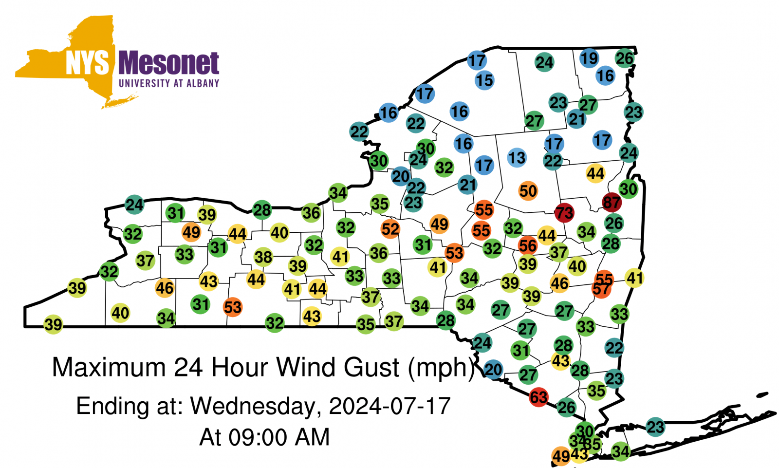 |
| Maximum Wind Gusts on July 16, 2024 from the NYS Mesonet |
Public Information Statement
National Weather Service Albany NY
944 AM EDT Wed Jul 17 2024

...HIGHEST WIND REPORTS...

Location                     Speed     Time/Date       Lat/Lon

...Massachusetts...

...Berkshire County...
1 ESE Williamstown           66 MPH    0621 PM 07/16   42.70N/73.17W
Peru                         45 MPH    0650 PM 07/16   42.47N/73.02W
Pittsfield Municipal Airport 44 MPH    0544 PM 07/16   42.43N/73.28W

...New York...

...Albany County...
Albany Intl Ap               49 MPH    0535 PM 07/16   42.75N/73.80W
Medusa                       46 MPH    0530 PM 07/16   42.47N/74.17W
Voorheesville                40 MPH    0535 PM 07/16   42.65N/73.98W
2 W Guilderland              34 MPH    0615 PM 07/16   42.70N/73.93W

...Columbia County...
Kinderhook                   57 MPH    0605 PM 07/16   42.41N/73.72W
Copake                       33 MPH    0640 PM 07/16   42.14N/73.52W

...Dutchess County...
Hudson Valley Regional Airpo 36 MPH    0612 PM 07/16   41.63N/73.88W
Red Hook                     33 MPH    0615 PM 07/16   42.00N/73.88W

...Fulton County...
Broadalbin                   32 MPH    0505 PM 07/16   43.12N/74.15W
Oppenheim                    32 MPH    0415 PM 07/16   43.06N/74.67W

...Hamilton County...
Piseco                       50 MPH    0440 PM 07/16   43.46N/74.50W
6 ENE Piseco                 39 MPH    0500 PM 07/16   43.47N/74.41W

...Herkimer County...
Cold Brook                   55 MPH    0405 PM 07/16   43.26N/74.98W
Herkimer                     53 MPH    0400 PM 07/16   43.04N/75.01W
Little Falls                 39 MPH    0405 PM 07/16   43.05N/74.89W

...Montgomery County...
Sprakers                     56 MPH    0445 PM 07/16   42.87N/74.51W
Hessville                    45 MPH    0440 PM 07/16   42.86N/74.72W
Johnstown                    43 MPH    0500 PM 07/16   42.98N/74.30W
Amsterdam                    30 MPH    0515 PM 07/16   42.97N/74.17W

...Rensselaer County...
Schodack                     55 MPH    0555 PM 07/16   42.51N/73.69W
Stephentown                  41 MPH    0630 PM 07/16   42.53N/73.36W
Brunswick                    39 MPH    0600 PM 07/16   42.77N/73.58W

...Saratoga County...
Edinburg                     73 MPH    0445 PM 07/16   43.23N/74.11W
1 NW The Saratoga Battllefie 48 MPH    0538 PM 07/16   43.01N/73.65W
Ballston Spa                 34 MPH    0520 PM 07/16   43.02N/73.88W
Saratoga Springs             33 MPH    0519 PM 07/16   43.05N/73.87W
Mechanicvile                 31 MPH    0545 PM 07/16   42.90N/73.75W

...Schenectady County...
Duanesburg                   37 MPH    0505 PM 07/16   42.80N/74.17W

...Schoharie County...
Cobleskill                   47 MPH    0450 PM 07/16   42.66N/74.43W
Cobleskill                   37 MPH    0450 PM 07/16   42.68N/74.51W

...Ulster County...
Wallkill                     43 MPH    0555 PM 07/16   41.63N/74.15W
3 SSW Tivoli                 38 MPH    0618 PM 07/16   42.01N/73.94W
New Paltz                    33 MPH    0609 PM 07/16   41.73N/74.09W

...Warren County...
Glens Falls                  87 MPH    0530 PM 07/16   43.34N/73.60W
Floyd Bennett Memorial Airpo 69 MPH    0525 PM 07/16   43.33N/73.62W
Chestertown                  44 MPH    0535 PM 07/16   43.65N/73.78W
Silver Bay                   32 MPH    0600 PM 07/16   43.67N/73.52W

...Washington County...
Granville                    31 MPH    0545 PM 07/16   43.39N/73.27W
5 S Whitehall                30 MPH    0545 PM 07/16   43.49N/73.42W

...Vermont...

...Bennington County...
Bennington State Airport     39 MPH    0617 PM 07/16   42.90N/73.25W
3.1 W Woodford State Park (V 35 MPH    0849 PM 07/16   42.88N/73.09W
1.6 NE Old Bennington (VTRAN 33 MPH    0609 PM 07/16   42.91N/73.20W
Rt-9 Searsburg               31 MPH    0855 PM 07/16   42.89N/72.97W

...Windham County...
I-91 Rockingham              36 MPH    0645 PM 07/16   43.18N/72.46W
E.Dummerston                 33 MPH    0500 PM 07/16   42.94N/72.53W
West Dover                   32 MPH    0955 PM 07/16   42.96N/72.82W

&&
Environment
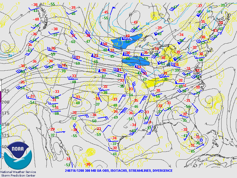
300 hPa Analysis
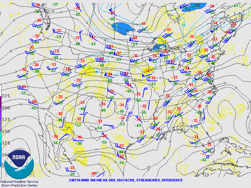 |
 |
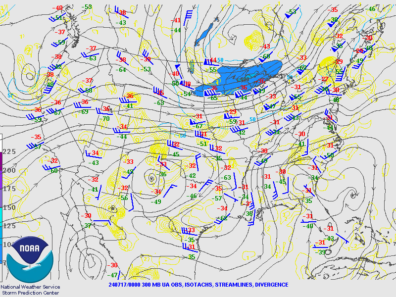 |
| Valid 00z July 16, 2024 | Valid 12z July 16, 2024 | Valid 00z July 17, 2024 |
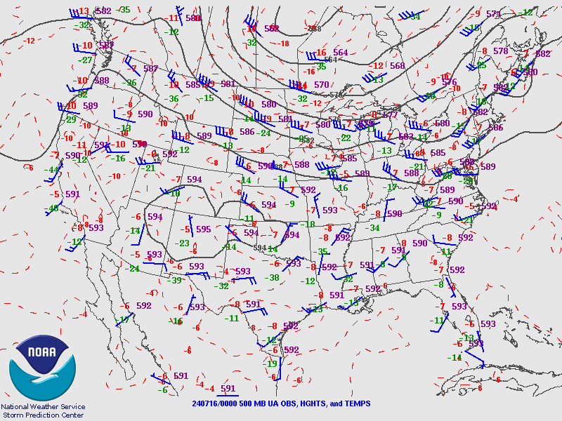
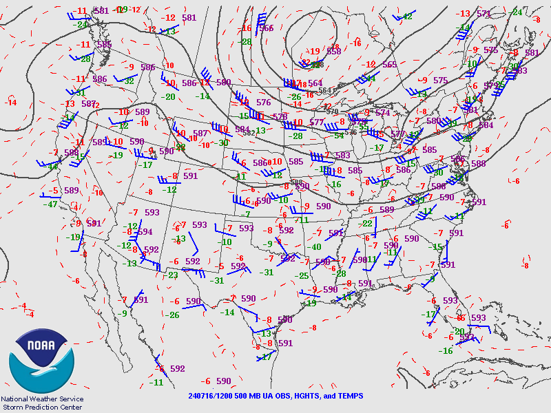
500 hPa Analysis
 |
 |
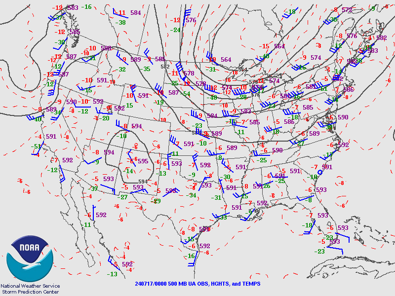 |
| Valid 00z July 16, 2024 | Valid 12z July 16, 2024 | Valid 00z July 17, 2024 |
850 hPa Analysis
 |
 |
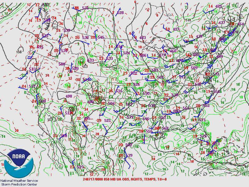 |
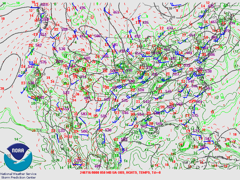
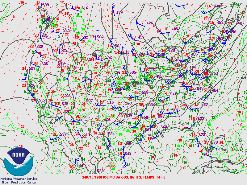
| Valid 00z July 16, 2024 | Valid 12z July 16, 2024 | Valid 00z July 17, 2024 |
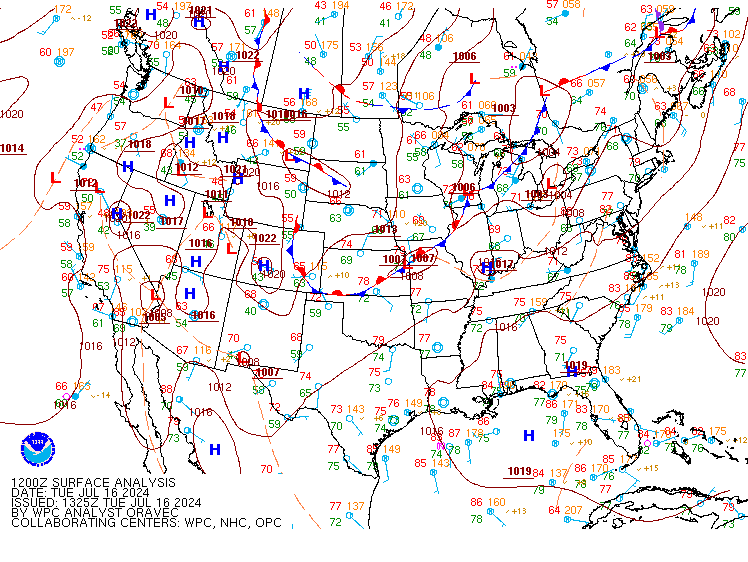
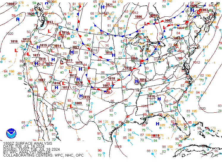
Surface Analysis
 |
 |
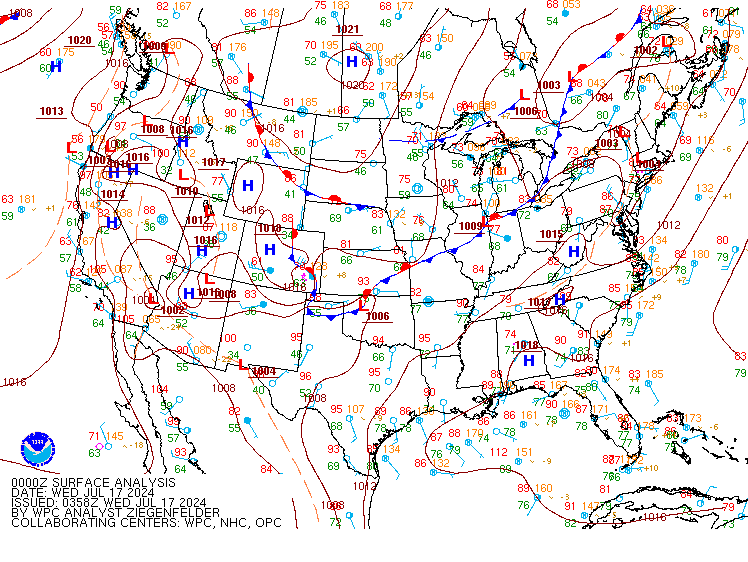 |
| Valid 12z July 16, 2024 | Valid 18z July 16, 2024 | Valid 00z July 17, 2024 |
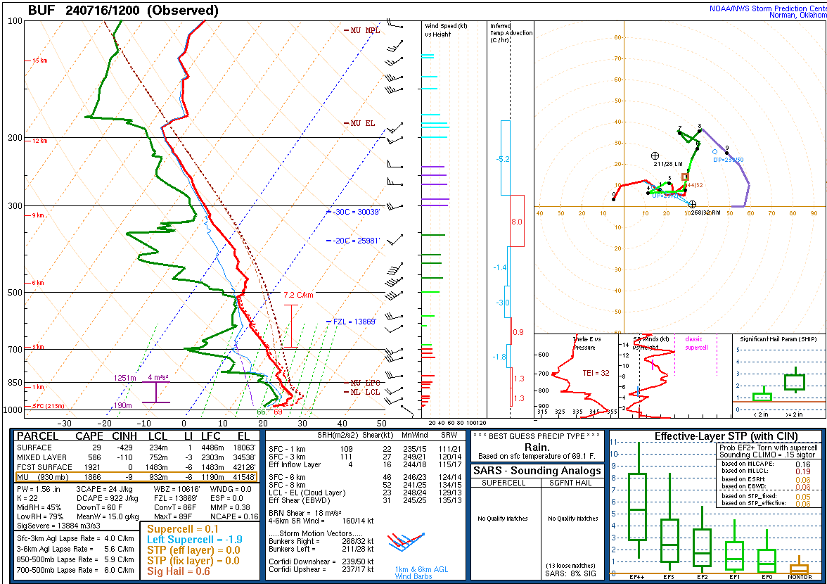
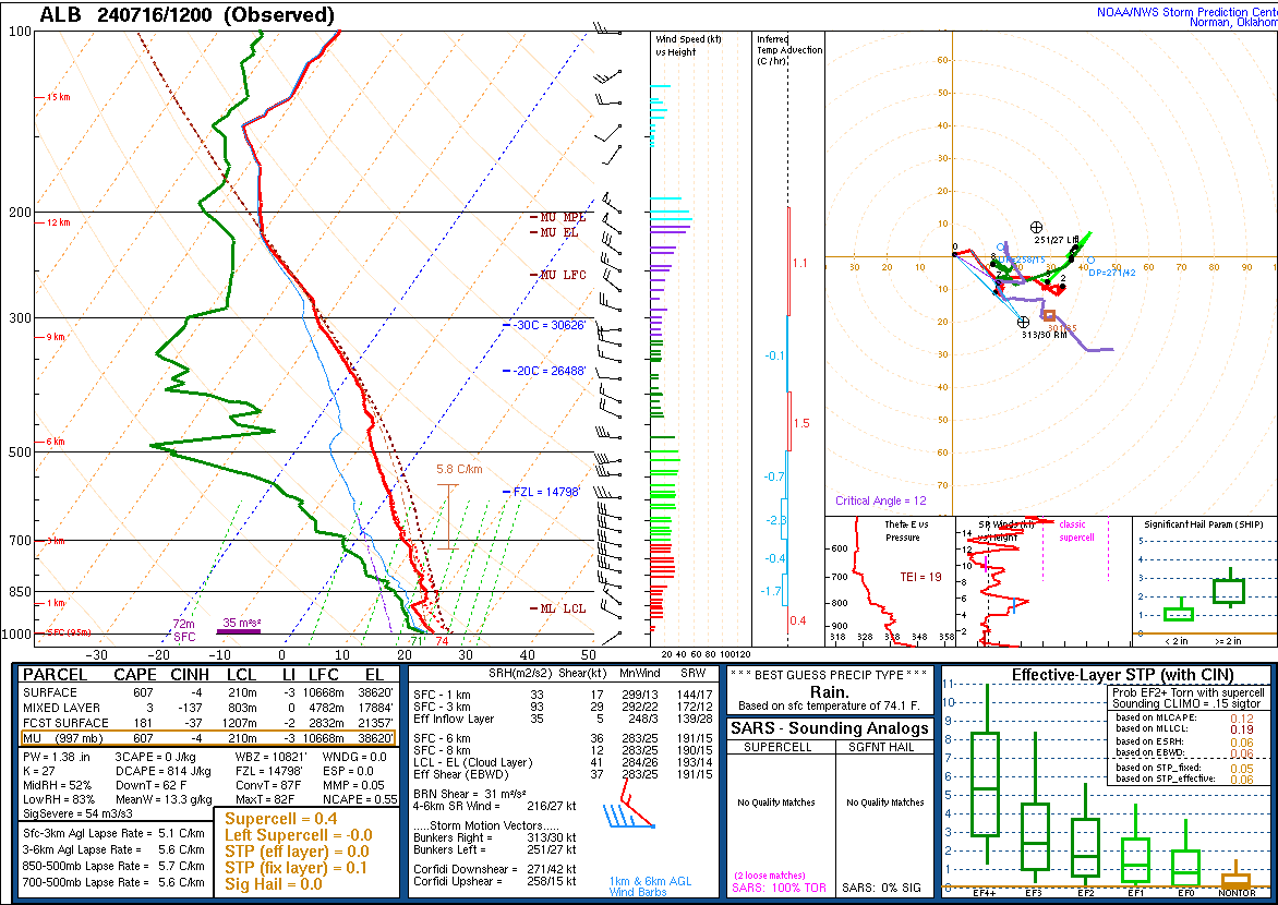
Upper Air Soundings
 |
 |
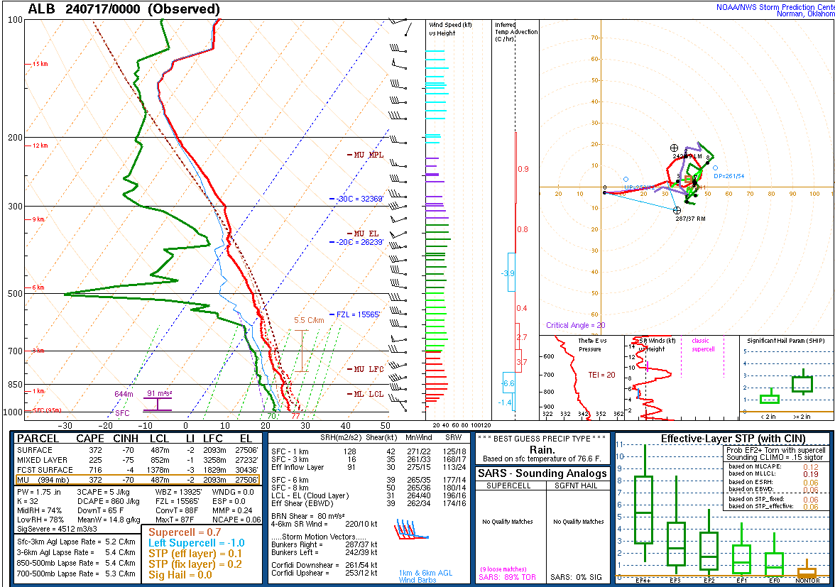 |
| 12 UTC July 16, 2024 KBUF Sounding | 12 UTC July 16, 2024 KALY Sounding | 00 UTC July 17, 2024 KALY Sounding |
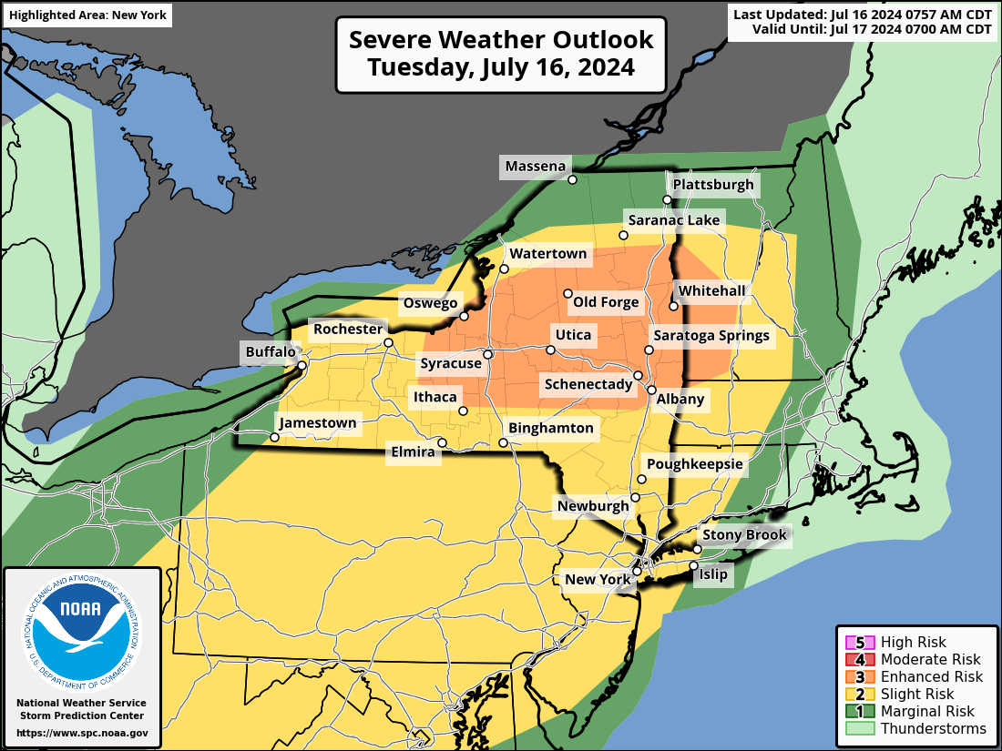
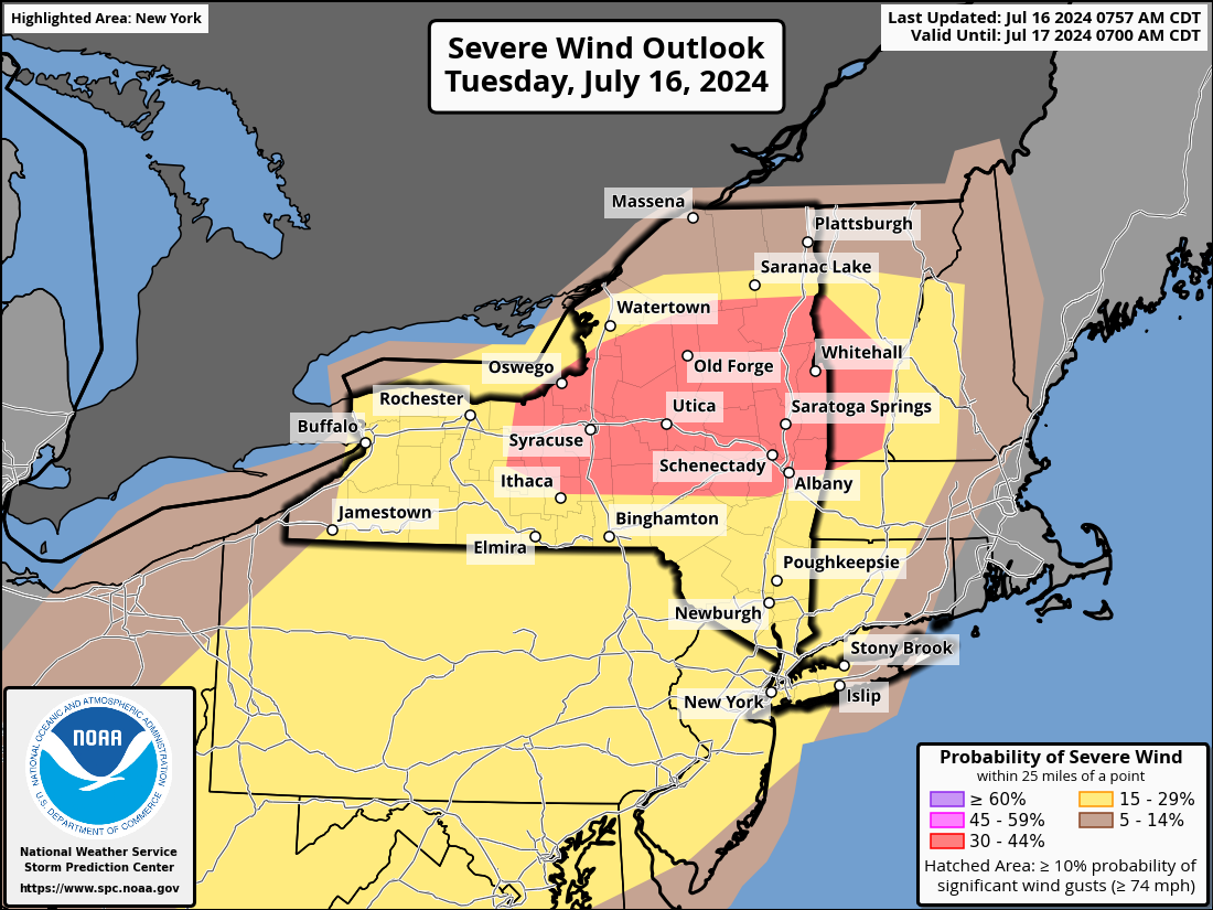
Storm Prediction Center Products
 |
 |
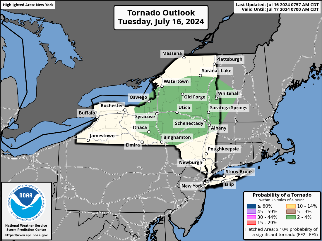 |
| Severe Weather Outlook (updated 8:57 AM EDT July 16, 2024) | Severe Wind Probabilities (updated 8:57 AM EDT July 16, 2024) | Tornado Probabilities (updated 8:57 AM EDT July 16, 2024) |
 |
 |
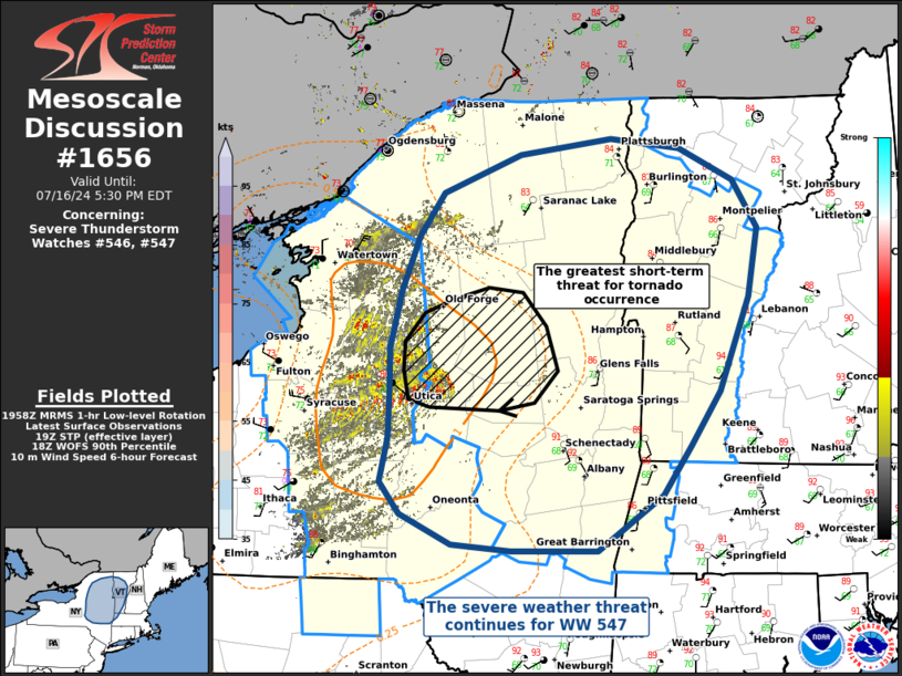 |
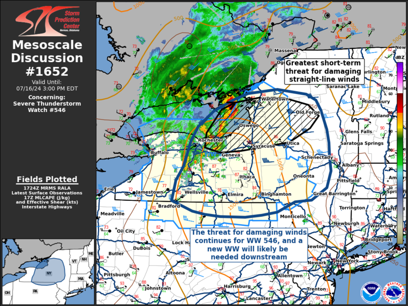
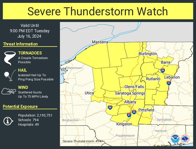
| Mesoscale Discussion #1652 (Link to Text Discussion) | Severe Thunderstorm Watch #547 (issued 1:50 PM EDT July 16, 2024) | Mesoscale Discussion #1656 (Link to Text Discussion) |
 |
Media use of NWS Web News Stories is encouraged! Please acknowledge the NWS as the source of any news information accessed from this site. |
|

