 |
 |
| Schenectady, NY (Ingrid Amberger) | Berkshires MA (Neil Stuart) |
Overview
A cold front moved across the region Wednesday, December 10th, ushering in a cold airmass back into the region.
A low pressure system developed over the southeastern states Wednesday and Wednesday night. This storm then
headed northeast Thursday and Thursday night with precipitation spreading northward well in advance of the
low. The low continued to track northeast passing over the mid Atlantic region late Thursday night and over
the New York Metropolitan area and southern New England Friday morning the 12th. The low moved to the
Canadian Maritimes Friday night.

As the storm approached warmer air moved in aloft and with a cold airmass in place at the surface, this set the
stage for a mixed precipitation event. The precipitation came down heavy at times, especially Thursday night.
Hourly precipitation rates of quarter to a third of an inch were reported for several hours in the form of
freezing rain across much of the forecast area. Thunder was even reported in Glens Falls. By the time the
precipitation tapered off Friday morning ice accumulations ranged from around half of an inch up to an inch
across portions of the Capital District and the Berkshires. North and west of the Capital District temperatures
were colder and frozen precipitation fell. Snowfall reports ranged from 2 to 4 inches just north and west of
the Capital District where sleet mixed in along with lesser ice accumulations, up to 8 to 12 inches across
portions of the southern Adirondacks.

Across the central and southeastern Catskills, mid Hudson Valley into the Berkshires and Litchfield County
heavy rainfall, 2 to 4 inches, lead to widespread urban and small stream flooding with some river flooding.
River flooding was observed on the Hoosic River, Esopus Creek, Housatonic River, Batten Kill, Still River
and Wappingers Creek. The Housatonic River reached moderate flooding levels at Falls Village, Gaylordsville
and at Stevenson Dam.

In the wake of the storm, temperatures tumbled Friday night with teens across much of the local area, single
digits across the higher terrain and even below zero temperatures across portions of the Adirondacks. There
was little recovery on Saturday as arctic high pressure crested over the region. Temperatures began to moderate
Sunday as the high shifted offshore and winds become southerly.

There was widespread tree and power line damage across the local area. An estimated 350,000 utility customers
lost power across East Central New York and adjacent western New England. Over 60,000 customers were still
out of power Monday morning, December 15th and over 10,000 customers were still out of power Wednesday morning,
December 17th.
Snow & Ice Reports
PUBLIC INFORMATION STATEMENT
SPOTTER REPORTS
NATIONAL WEATHER SERVICE ALBANY NY
1103 PM EST FRI DEC 12 2008

THE FOLLOWING ARE UNOFFICIAL OBSERVATIONS TAKEN DURING THE PAST 24 HOURS FOR THE STORM THAT HAS BEEN
AFFECTING OUR REGION.  APPRECIATION IS EXTENDED TO HIGHWAY DEPARTMENTS...COOPERATIVE OBSERVERS...SKYWARN
SPOTTERS AND MEDIA FOR THESE REPORTS.  THIS SUMMARY IS ALSO AVAILABLE ON OUR HOME PAGE AT WEATHER.GOV/ALBANY

********************STORM TOTAL SNOWFALL********************

LOCATION          STORM TOTAL    TIME/DATE    COMMENTS
                     SNOWFALL       OF
                     (INCHES)   MEASUREMENT

MASSACHUSETTS

...BERKSHIRE COUNTY...
   ALFORD                 3.0  1144 AM 12/12 WXNET 6

NEW YORK

...ALBANY COUNTY...
   POTTER HOLLOW          1.5  1156 AM 12/12 WXNET 6
   KNOX                   1.3   739 AM 12/12 WXNET 6
   COHOES                 1.0   616 PM 12/12 WXNET 6
   ALBANY                 0.1   100 PM 12/12 NWS/CESTM

...FULTON COUNTY...
   NORTHVILLE             7.5   549 AM 12/12 WXNET 6
   CAROGA LAKE            6.5   439 AM 12/12 WXNET 6
   GLOVERSVILLE           6.5   505 PM 12/12 WXNET 6
   PECK LAKE              6.4   700 AM 12/12 COOP
   MAYFIELD               6.0   644 AM 12/12 WXNET 6
   FISHHOUSE              2.0   505 AM 12/12 WXNET 6

...GREENE COUNTY...
   PRATTSVILLE            0.5  1120 AM 12/12 WXNET 6

...HAMILTON COUNTY...
   INDIAN LAKE            8.0  1212 PM 12/12 WXNET 6
   SPECULATOR             6.3   602 AM 12/12 WXNET 6
   WELLS                  6.0   927 AM 12/12 TRAINED SPOTTER 1010 FEET

...HERKIMER COUNTY...
   HERKIMER              10.5   855 PM 12/12 WKTV
   POLAND                 8.2   620 PM 12/12 TRAINED SPOTTER
   DOLGEVILLE             8.0  1233 PM 12/12 TRAINED SPOTTER
   CURTIS                 7.0   845 PM 12/12 WKTV
   POLAND                 6.5   917 AM 12/12 TRAINED SPOTTER
   MOHAWK                 6.0  1045 PM 12/11 TRAINED SPOTTER
   OLD FORGE              4.0   602 AM 12/12 TRAINED SPOTTER
   SALISBURY              3.6  1046 PM 12/11 WKTV

...MONTGOMERY COUNTY...
   AMSTERDAM              5.0   524 PM 12/12 WXNET 6
   FONDA                  4.5   855 PM 12/12 WKTV
   AMSTERDAM              4.0   500 PM 12/12 WXNET 6
   FONDA                  4.0   518 PM 12/12 WXNET 6
   HESSVILLE              4.0   543 PM 12/12 WXNET 6
   TRIBES HILL            2.5   706 AM 12/12 COOP
   GLEN                   2.0   609 PM 12/12 WXNET 6
   PALATINE BRIDGE        1.5   507 AM 12/12 WXNET 6

...RENSSELAER COUNTY...
   BRUNSWICK              0.5   900 AM 12/12 NWS EMPLOYEE
   BUSKIRK                0.4   706 AM 12/12 COOP

...SARATOGA COUNTY...
   PORTER CORNERS         6.0  1113 PM 12/11 WXNET 6
   CORINTH                5.0   556 PM 12/12 WXNET 6
   MIDDLE GROVE           4.5   550 AM 12/12 WXNET 6
   GANSEVOORT             2.8   613 AM 12/12 WXNET 6

...SCHOHARIE COUNTY...
   RICHMONDVILLE          2.0   516 PM 12/12 WXNET 6
   JEFFERSON              0.5   539 PM 12/12 WXNET 6
   CHARLOTTEVILLE         0.4   615 PM 12/12 WXNET 6

...WARREN COUNTY...
   BRANT LAKE             7.5  1140 AM 12/12 WXNET 6
   LAKE LUZERNE           7.5   601 PM 12/12 TRAINED SPOTTER
   NORTH CREEK            6.2   700 AM 12/12 COOP
   GLENS FALLS            6.1   344 AM 12/12 MEDIA
   WARRENSBURG            5.7   800 AM 12/12 TRAINED SPOTTER

...WASHINGTON COUNTY...
   FORT EDWARD            5.0   546 PM 12/12 WXNET 6
   GRANVILLE              4.0   600 PM 12/12 WXNET 6
   WHITEHALL              4.0   622 AM 12/12 WXNET 6
   HEBRON                 3.0   814 AM 12/12 WXNET 6
   HUDSON FALLS           3.0   648 AM 12/12 WXNET 6
   NORTH HEBRON           3.0   230 PM 12/12 TRAINED SPOTTER

VERMONT

...BENNINGTON COUNTY...
   WOODFORD               7.5  1100 AM 12/12 SPOTTER

...WINDHAM COUNTY...
   BALL MOUNTAIN LAKE     1.0   700 AM 12/12 SPOTTER


***********************STORM TOTAL ICE***********************

LOCATION          STORM TOTAL    TIME/DATE    COMMENTS
                          ICE       OF
                     (INCHES)   MEASUREMENT


CONNECTICUT

...LITCHFIELD COUNTY...
   TORRINGTON            0.50   132 PM 12/12 TRAINED SPOTTER
   WINSTED               0.50   224 AM 12/12 TRAINED SPOTTER

MASSACHUSETTS

...BERKSHIRE COUNTY...
   PERU                  1.00   137 AM 12/12 TRAINED SPOTTER - 2000 FT
   SAVOY                 0.60  1100 PM 12/11 WXNET 6

NEW YORK

...ALBANY COUNTY...
   COLONIE               0.80   440 PM 12/12 WXNET 6
   FEURA BUSH            0.75   510 PM 12/12 WXNET 6
   ALBANY                0.60   100 PM 12/12 NWS/CESTM
   WESTERLO              0.25  1100 PM 12/11 WXNET 6


...DUTCHESS COUNTY...
   RED OAKS MILL         0.35   221 AM 12/12 TRAINED SPOTTER

...GREENE COUNTY...
   CATSKILL              0.50   515 PM 12/12 WXNET 6

...RENSSELAER COUNTY...
   BRUNSWICK             0.50   828 AM 12/12 NWS EMPLOYEE

...SARATOGA COUNTY...
   CLIFTON PARK          0.60   625 AM 12/12 NWS EMPLOYEE
   ROUND LAKE            0.60   845 AM 12/12 NWS EMPLOYEE

...SCHENECTADY COUNTY...
   SCHENECTADY           0.88   810 AM 12/12 NWS EMPLOYEE
   NISKAYUNA             0.50   224 AM 12/12 NWS EMPLOYEE

...SCHOHARIE COUNTY...
   MIDDLEBURGH           0.75   940 AM 12/12 TRAINED SPOTTER  2100 FEET
   RICHMONDVILLE         0.75   645 AM 12/12 TRAINED SPOTTER ELEVATION 1650 FEET

...WARREN COUNTY...
   GLENS FALLS           0.10   344 AM 12/12 MEDIA

...WASHINGTON COUNTY...
   NORTH HEBRON          0.25   230 PM 12/12 TRAINED SPOTTER

VERMONT

...BENNINGTON COUNTY...
   WOODFORD              0.75  1205 PM 12/12 WXNET 6
   READSBORO             0.50  1155 PM 12/11 TRAINED SPOTTER

...WINDHAM COUNTY...
   BELLOWS FALLS         0.50   221 AM 12/12 TRAINED SPOTTER

$$
Precipitation Reports
PUBLIC INFORMATION STATEMENT
SPOTTER REPORTS
NATIONAL WEATHER SERVICE ALBANY NY
1103 PM EST FRI DEC 12 2008

THE FOLLOWING ARE UNOFFICIAL OBSERVATIONS TAKEN DURING THE PAST 24 HOURS FOR THE STORM THAT HAS BEEN
AFFECTING OUR REGION.  APPRECIATION IS EXTENDED TO HIGHWAY DEPARTMENTS...COOPERATIVE OBSERVERS...SKYWARN
SPOTTERS AND MEDIA FOR THESE REPORTS.  THIS SUMMARY IS ALSO AVAILABLE ON OUR HOME PAGE AT WEATHER.GOV/ALBANY

********************STORM TOTAL RAINFALL********************

LOCATION          STORM TOTAL    TIME/DATE    COMMENTS
                     RAINFALL       OF
                     (INCHES)   MEASUREMENT


CONNECTICUT

...LITCHFIELD COUNTY...
   BULLS BRIDGE DAM      3.60   600 AM 12/12 COOP
   BAKERSVILLE           3.21   700 AM 12/12 COOP
   BLACK ROCK LAKE       3.01   700 AM 12/12 COOP
   FALLS VILLAGE         2.94   600 AM 12/12 COOP
   COLEBROOK LAKE        2.92   700 AM 12/12 COOP
   THOMASTON DAM         2.74   700 AM 12/12 COOP
   NEW MILFORD           2.70   902 AM 12/12 TRAINED SPOTTER ELEVATION 740 FT
   CANAAN                2.16   513 AM 12/12 WXNET 6
   ROCKY RIVER           1.82   700 AM 12/12 COOP
   SHEPAUG DAM           1.62   700 AM 12/12 COOP

MASSACHUSETTS

...BERKSHIRE COUNTY...
   LENOX DALE            3.62   700 AM 12/12 COOP
   PITTSFIELD            3.10   700 AM 12/12 ASOS
   ALFORD                3.00   558 PM 12/12 WXNET 6
   NORTH ADAMS           2.27   700 AM 12/12 ASOS
   GREAT BARRINGTON      1.17   700 AM 12/12 COOP

NEW YORK

...ALBANY COUNTY...
   ALBANY                2.07   100 PM 12/12 NWS/CESTM
   COLONIE               2.03  1024 PM 12/12 WXNET 6
   MEDUSA                0.92   508 PM 12/12 WXNET 6

...COLUMBIA COUNTY...
   LIVINGSTON            1.31   700 AM 12/12 COOP

...DUTCHESS COUNTY...
   STORMVILLE            4.17   848 AM 12/12 TRAINED SPOTTER
   MILLBROOK             3.45   700 AM 12/12 COOP
   POUGHKEEPSIE          3.21   700 AM 12/12 ASOS
   SALT POINT            3.20  1016 AM 12/12 TRAINED SPOTTER
   UNION VALE            3.14   735 AM 12/12 WXNET 6
   RED HOOK              2.85   700 AM 12/12 WXNET 6
   POUGHQUAG             2.64   911 AM 12/12 TRAINED SPOTTER
   RED OAKS MILL         1.54   221 AM 12/12 TRAINED SPOTTER

...FULTON COUNTY...
   PECK LAKE             0.61   700 AM 12/12 COOP

...GREENE COUNTY...
   TANNERSVILLE          2.70   701 AM 12/12 COOP
   CATSKILL              2.35   536 PM 12/12 WXNET 6

...HAMILTON COUNTY...
   INDIAN LAKE           0.85  1002 AM 12/12 COOP

...HERKIMER COUNTY...
   CHEPACHET             1.20  1003 AM 12/12 COOP
   LITTLE FALLS          1.03   704 AM 12/12 COOP
   OLD FORGE             0.99   705 AM 12/12 COOP
   OLD FORGE             0.49  1120 AM 12/12 COCORAHS

...MONTGOMERY COUNTY...
   TRIBES HILL           1.33   706 AM 12/12 COOP
   FONDA                 1.09  1120 AM 12/12 COCORAHS

...RENSSELAER COUNTY...
   STEPHENTOWN           3.50   450 PM 12/12 WXNET 6
   BUSKIRK               2.84   706 AM 12/12 COOP
   NORTH PETERSBURG      2.37   715 AM 12/12 COOP
   BRUNSWICK             2.36   900 AM 12/12 NWS EMPLOYEE
   EAST GREENBUSH        2.32   707 AM 12/12 COOP

...SARATOGA COUNTY...
   SARATOGA SPRINGS      1.68  1120 AM 12/12 COCORAHS
   GANSEVOORT            1.58  1120 AM 12/12 COCORAHS
   CONKLINGVILLE         1.41   700 AM 12/12 COOP

...SCHENECTADY COUNTY...
   SCHENECTADY           2.20   757 AM 12/12 NWS EMPLOYEE
   SCOTIA                1.00  1120 AM 12/12 COCORAHS

...SCHOHARIE COUNTY...
   RICHMONDVILLE         1.75   541 AM 12/12 WXNET 6
   COBLESKILL            1.67   700 AM 12/12 COOP
   MANORKILL             1.48   700 AM 12/12 COOP
   SCHOHARIE             0.95   700 AM 12/12 COOP
   CHARLOTTEVILLE        0.76   700 AM 12/12 COOP

...ULSTER COUNTY...
   SAUGERTIES            4.00   700 AM 12/12 COOP
   KINGSTON              3.90   700 AM 12/12 COOP
   NEW PALTZ             3.47   700 AM 12/12 COOP
   PHOENICIA             3.25  1024 AM 12/12 COOP
   SAUGERTIES            3.22   700 AM 12/12 COOP
   KINGSTON              3.17  1120 AM 12/12 COCORAHS
   WHITEPORT             3.16   431 PM 12/12 WXNET 6
   BEARSVILLE            3.15   700 AM 12/12 COOP
   WEST SHOKAN           3.14   717 AM 12/12 WXNET 6
   ROSENDALE             3.06  1120 AM 12/12 COCORAHS
   PHOENICIA             2.54   611 AM 12/12 WXNET 6

...WARREN COUNTY...
   GLENS FALLS           1.56   700 AM 12/12 COOP
   NORTH CREEK           0.85   700 AM 12/12 COOP

...WASHINGTON COUNTY...
   NORTH HEBRON          1.50   700 AM 12/12 SPOTTER

VERMONT

...BENNINGTON COUNTY...
   BENNINGTON AIRPORT    1.91   700 AM 12/12 COOP

...WINDHAM COUNTY...
   TOWNSHEND             2.72   340 PM 12/12 TRAINED SPOTTER
   TOWNSHEND LAKE        2.51   700 AM 12/12 COOP
   BELLOWS FALLS         2.38   851 AM 12/12 TRAINED SPOTTER
   BRATTLEBORO           1.43   700 AM 12/12 COOP
   MOUNT SNOW            1.01   700 AM 12/12 COOP

$$
Photos
 |
 |
 |
 |
| North Colonie, NY (Neil Stuart) |
North Colonie, NY (Neil Stuart) |
Bike Path/North Colonie, NY (Neil Stuart) |
Bike Path/North Colonie, NY (Neil Stuart) |
 |
 |
 |
 |
| Brunswick, NY (Judy Hagemann) |
Niskayuna, NY (Ingrid Amberger) |
Niskayuna, NY (Ingrid Amberger) |
I-90 NY-MA Border (Neil Stuart) |
Radar Loop & Precipitation Map:
 |
 |
| 8 am Dec 11th - 11 am Dec 12th, 2008 | 24-hour Precipitation: 7 am Dec 11th - 7 am Dec 12th, 2008 |
Environment
Upper Air Soundings - Albany NY
 |
 |
 |
| 1 pm December 11, 2008 | 7 pm December 11, 2008 | 7 am December 12, 2008 |
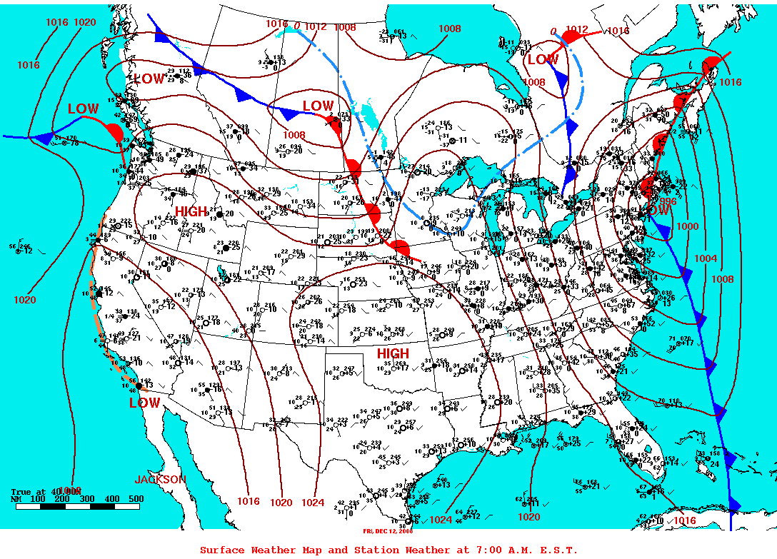
Surface maps valid at 7 am EST
 |
 |
 |
| December 11, 2008 | December 12, 2008 | December 13, 2008 |
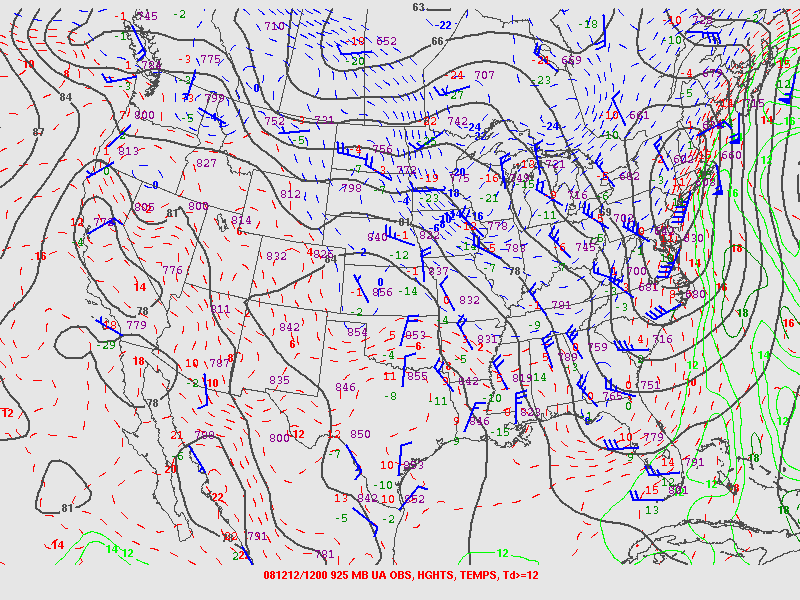
925 mb maps valid at 7 am EST
 |
 |
 |
| December 11, 2008 | December 12, 2008 | December 13, 2008 |
850 mb maps valid at 7 am EST
 |
 |
 |
| December 11, 2008 | December 12, 2008 | December 13, 2008 |
500 mb maps valid at 7 am EST
 |
 |
 |
| December 11, 2008 | December 12, 2008 | December 13, 2008 |
250 mb maps valid at 7 am EST
 |
 |
 |
| December 11, 2008 | December 12, 2008 | December 13, 2008 |
 |
Media use of NWS Web News Stories is encouraged! Please acknowledge the NWS as the source of any news information accessed from this site. |
|

