Overview
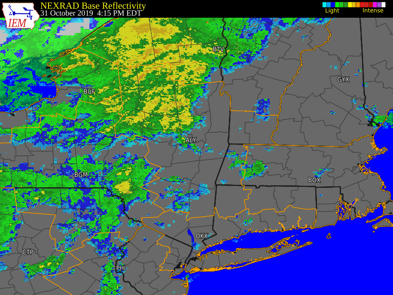
A strengthening low pressure system moving from Ohio to Lake Ontario drew anomalous warmth and moisture northward on Halloween, with temperatures surging into the 60s and 70s over eastern New York and western New England. Showers across the southern Adirondacks and Mohawk Valley became steadier and heavier during the evening ahead of a strong cold front as the low continued to strengthen. Strong winds aloft mixed down to the surface as an intense line of showers developed along the front, resulting in sporadic wind damage over eastern New York and western New England. A large swath of rainfall totaling 2-5 inches occurred over the Mohawk Valley and southern Adirondacks, resulting in reports of flash flooding. The runoff caused rapid rises on area creeks and streams, with four river gauges reaching record levels. The flooding was extensive over portions of the area, damaging numerous roads and structures and resulting in water rescues. There was one fatality as a result of the flooding.
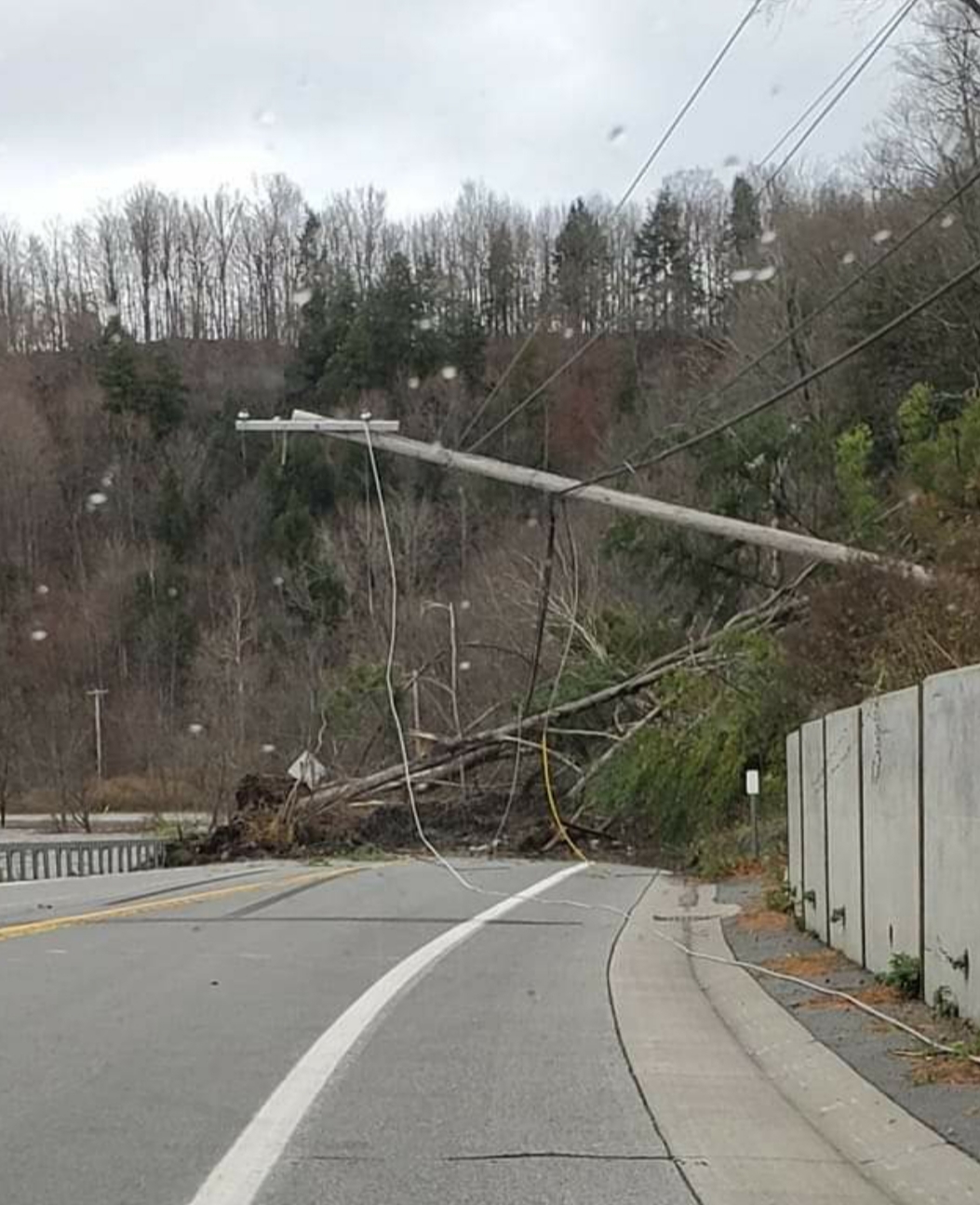
Behind the cold front, strong gusty westerly winds developed and persisted into the afternoon November 1st. The winds gusted as high as 63 mph, resulting in numerous reports of downed trees and thousands of power outages.
Flooding
Hydrographs
 |
 |
 |
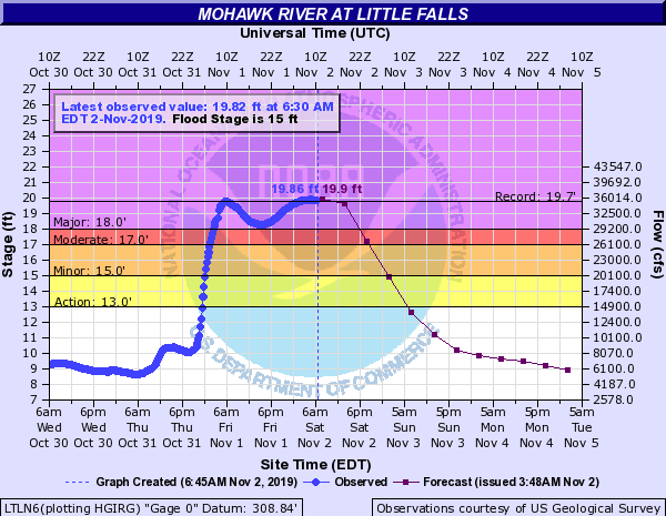 |
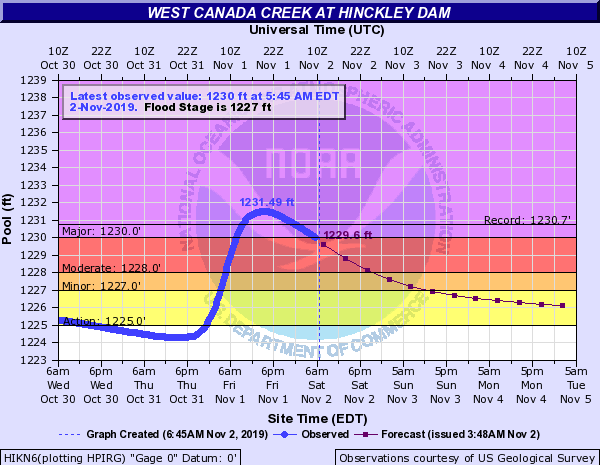
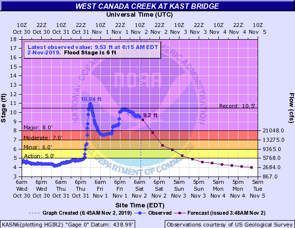
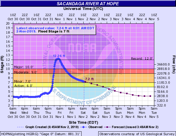
| Hydrograph showing record flooding on the West Canada Creek at Hinckley Dam | Hydrograph showing record flooding on the West Canada Creek at Kast Bridge | Hydrograph showing record flooding on the Sacandaga River at Hope | Hydrograph showing record flooding on the Mohawk River at Little Falls |
PRELIMINARY LOCAL STORM REPORT...SUMMARY
NATIONAL WEATHER SERVICE ALBANY NY
449 PM EDT FRI NOV 01 2019

..TIME...   ...EVENT...      ...CITY LOCATION...     ...LAT.LON...
..DATE...   ....MAG....      ..COUNTY LOCATION..ST.. ...SOURCE....
            ..REMARKS..

0800 PM     FLOOD            NEWPORT                 43.19N  75.02W
10/31/2019                   HERKIMER           NY   911 CALL CENTER

            TWO INCHES OF WATER ACROSS MAIN STREET

0830 PM     FLASH FLOOD      7 SW SCHUYLER           43.05N  75.21W
10/31/2019                   HERKIMER           NY   TRAINED SPOTTER

            2-3' OF WATER ON GRAFFENBURG RD.

0830 PM     FLASH FLOOD      COLD BROOK              43.24N  75.04W
10/31/2019                   HERKIMER           NY   TRAINED SPOTTER

            1-2' OF WATER ON MAIN STREET

0900 PM     FLOOD            MIDDLEVILLE             43.14N  74.97W
10/31/2019                   HERKIMER           NY   TRAINED SPOTTER

            VILLAGE WIDE FLOODING REPORTED.

0900 PM     FLASH FLOOD      2 SSW NEWPORT           43.16N  75.04W
10/31/2019                   HERKIMER           NY   TRAINED SPOTTER

            NEWPORT ROAD WASHED OUT.

0956 PM     FLASH FLOOD      FRANKFORT               43.04N  75.07W
10/31/2019                   HERKIMER           NY   LAW ENFORCEMENT

            ONGOING FLOODING WITH RT. 5 CLOSED BETWEEN WINDFALL RD.
            AND DRIVE IN RD.

1000 PM     FLASH FLOOD      FRANKFORT               43.04N  75.07W
10/31/2019                   HERKIMER           NY   LAW ENFORCEMENT

            ONGOING FLOODING WITH ROAD CLOSURE ON RT. 5S NEAR MUCKY
            RUN RD.

1000 PM     FLASH FLOOD      SPECULATOR              43.58N  74.38W
10/31/2019                   HAMILTON           NY   LAW ENFORCEMENT

            ROUTE 30 CLOSED BETWEEN SPECULATOR AND INDIAN LAKE.

1003 PM     FLASH FLOOD      SCHUYLER                43.11N  75.10W
10/31/2019                   HERKIMER           NY   LAW ENFORCEMENT

            ONGOING FLOODING WITH RT. 5 CLOSED BETWEEN NEWPORT RD.
            AND MILLERS GROVE RD.

1012 PM     FLASH FLOOD      MIDDLEVILLE             43.14N  74.97W
10/31/2019                   HERKIMER           NY   LAW ENFORCEMENT

            ONGOING FLOODING WITH RT. 28 CLOSED BETWEEN MIDDLEVILLE
            AND POLAND.

1030 PM     FLOOD            3 ENE NEWPORT           43.21N  74.96W
10/31/2019                   HERKIMER           NY   EMERGENCY MNGR

            *** 1 FATAL *** ELDERLY MALE SWEPT AWAY FROM VEHICLE ON
            MILITARY ROAD.

1056 PM     FLASH FLOOD      FRANKFORT               43.04N  75.07W
10/31/2019                   HERKIMER           NY   LAW ENFORCEMENT

            ONGOING FLOODING WITH RT. 5S CLOSED DUE TO MUDSLIDE
            AROUND CULVERT AVE.

1135 PM     FLASH FLOOD      BRANT LAKE              43.68N  73.75W
10/31/2019                   WARREN             NY   LAW ENFORCEMENT

            ONGOING FLOODING WITH RT. 8 CLOSED IN TOWN OF HORICON
            BETWEEN DUELL HILL RD. AND PALISADES RD.

0225 AM     FLOOD            PALATINE BRIDGE         42.91N  74.58W
11/01/2019                   MONTGOMERY         NY   LAW ENFORCEMENT

            STATE ROUTE 5 BETWEEN GROFF AND STALEY ROAD IS CLOSED
            IN THE TOWN DUE TO FLOODING.

0243 AM     FLOOD            AMSTERDAM               42.94N  74.19W
11/01/2019                   MONTGOMERY         NY   LAW ENFORCEMENT

            STATE ROUTE 5S IS CLOSED BETWEEN PATTERSONVILLE ROAD
            AND BULLS HEAD RD.

0500 AM     FLOOD            5 SSE WELLS             43.32N  74.26W
11/01/2019                   HAMILTON           NY   EMERGENCY MNGR

            ROUTE 30 IS CLOSED BETWEEN BENSON AND WELLS DUE TO
            WATER OVER THE ROAD

0500 AM     FLOOD            9 NE WELLS              43.49N  74.19W
11/01/2019                   HAMILTON           NY   EMERGENCY MNGR

            ROUTE 8 IS CLOSED BETWEEN WELLS AND WEVERTOWN DUE TO
            FLOODING

0500 AM     FLOOD            WELLS                   43.39N  74.29W
11/01/2019                   HAMILTON           NY   EMERGENCY MNGR

            WIDESPREAD FLOODING OCCURRED IN WELLS, PROMPTING
            RESCUES BY AIRBOAT

0630 AM     FLOOD            3 ESE AMSTERDAM         42.92N  74.14W
11/01/2019                   MONTGOMERY         NY   TRAINED SPOTTER

            FLOODING NEAR LOCK 10 IN CRANESVILLE. ROUTE 5S FROM
            PATTERSONVILLE RD TO BULLSHEAD ROAD CLOSED.

0642 AM     FLOOD            2 E SALISBURY           43.14N  74.80W
11/01/2019                   HERKIMER           NY   DEPT OF HIGHWAYS

            ROUTE 29 CLOSED OVER SPRUCE CREEK

0737 AM     FLOOD            DOLGEVILLE              43.10N  74.77W
11/01/2019                   HERKIMER           NY   FIRE DEPT/RESCUE

            EAST CANADA CREEK IS OVER ITS BANKS AND FLOWING INTO
            SOME RESIDENCES. SWIFT WATER RESCUES ONGOING.

0856 AM     FLOOD            1 NNE DAY CENTER        43.31N  74.01W
11/01/2019                   SARATOGA           NY   EMERGENCY MNGR

            HADLEY HILL ROAD CLOSED AT PAUL CREEK IN THE TOWN OF
            DAY. ONE LANE IS WASHED OUT.

0919 AM     FLOOD            3 E MIDDLEVILLE         43.14N  74.91W
11/01/2019                   HERKIMER           NY   TRAINED SPOTTER

            ROADS AND A BRIDGE ARE WASHED OUT IN THE TOWN OF
            FAIRFIELD. SWIFTWATER RECUES ARE ONGOING.

0944 AM     FLOOD            2 WNW POLAND            43.23N  75.09W
11/01/2019                   HERKIMER           NY   DEPT OF HIGHWAYS

            ROUTE 28 IS CLOSED BETWEEN BARNEVELD AND POLAND DUE TO
            FLOODING

0950 AM     FLOOD            4 SSE OHIO              43.26N  74.95W
11/01/2019                   HERKIMER           NY   SOCIAL MEDIA

            ROAD WASHED OUT ON HURRICANE ROAD IN GRAY.

0950 AM     FLOOD            3 SSE NORTHWOOD         43.31N  75.04W
11/01/2019                   HERKIMER           NY   SOCIAL MEDIA

            ROAD AND BRIDGE WASHED AWAY AT BLACK CREEK ROAD.

0950 AM     FLOOD            3 SSE OHIO              43.28N  74.95W
11/01/2019                   HERKIMER           NY   SOCIAL MEDIA

            ROAD AND BRIDGE WASHED AWAY ON GRAY WILMURT ROAD.

0956 AM     FLOOD            1 SSE LAKE LUZERNE-HADL 43.31N  73.83W
11/01/2019                   WARREN             NY   NEWSPAPER

            HUDSON RIVER FLOODING INTO STEPHEN LANE. RESIDENTS ARE
            EVACUATING.

1008 AM     FLOOD            2 SE LAKE DESOLATION    43.11N  73.94W
11/01/2019                   SARATOGA           NY   EMERGENCY MNGR

            COUNTY ROUTE 12 WASHED OUT AT BARNEY ROAD IN THE TOWN
            OF GREENFIELD

1020 AM     FLOOD            4 WSW NOBLEBORO         43.38N  74.93W
11/01/2019                   HERKIMER           NY   AMATEUR RADIO

            ONE LANE OF ROUTE 8 IS WASHED OUT BETWEEN ROUTE 365 AND
            GRAY-WILMURT ROAD

1032 AM     FLOOD            JOHNSBURG               43.52N  73.96W
11/01/2019                   WARREN             NY   EMERGENCY MNGR

            TWENTY-FIVE ROADS WERE WASHED OUT IN THE JOHNSBURG AREA
            DUE TO FLOODING

1042 AM     FLOOD            4 WSW DAY CENTER        43.29N  74.09W
11/01/2019                   SARATOGA           NY   EMERGENCY MNGR

            BRIDGE AT MILITARY ROAD AND SAND LAKE ROAD IN EDINBURG
            IS CLOSED DUE TO DAMAGE FROM FLOODING

1229 PM     FLOOD            1 SE FORT PLAIN         42.93N  74.62W
11/01/2019                   MONTGOMERY         NY   DEPT OF HIGHWAYS

            ROUTE 5S CLOSED BETWEEN ROUTE 80 AND ROUSE ROAD DUE TO
            FLOODING

1256 PM     FLOOD            FULTONVILLE             42.95N  74.37W
11/01/2019                   MONTGOMERY         NY   BROADCAST MEDIA

            WATER SURROUNDING A RESIDENCE. RESIDENTS WERE
            EVACUATED.

0233 PM     FLOOD            DOLGEVILLE              43.10N  74.77W
11/01/2019                   HERKIMER           NY   DEPT OF HIGHWAYS

            THE ROUTE 29 BRIDGE OVER THE EAST CANADA CREEK IS
            CLOSED DUE TO FLOODING

0332 PM     FLOOD            5 NNW CAROGA LAKE       43.20N  74.53W
11/01/2019                   FULTON             NY   DEPT OF HIGHWAYS

            ROUTE 10 IS CLOSED BETWEEN ROUTE 29A AND ROUTE 8 DUE TO
            FLOODING


&&
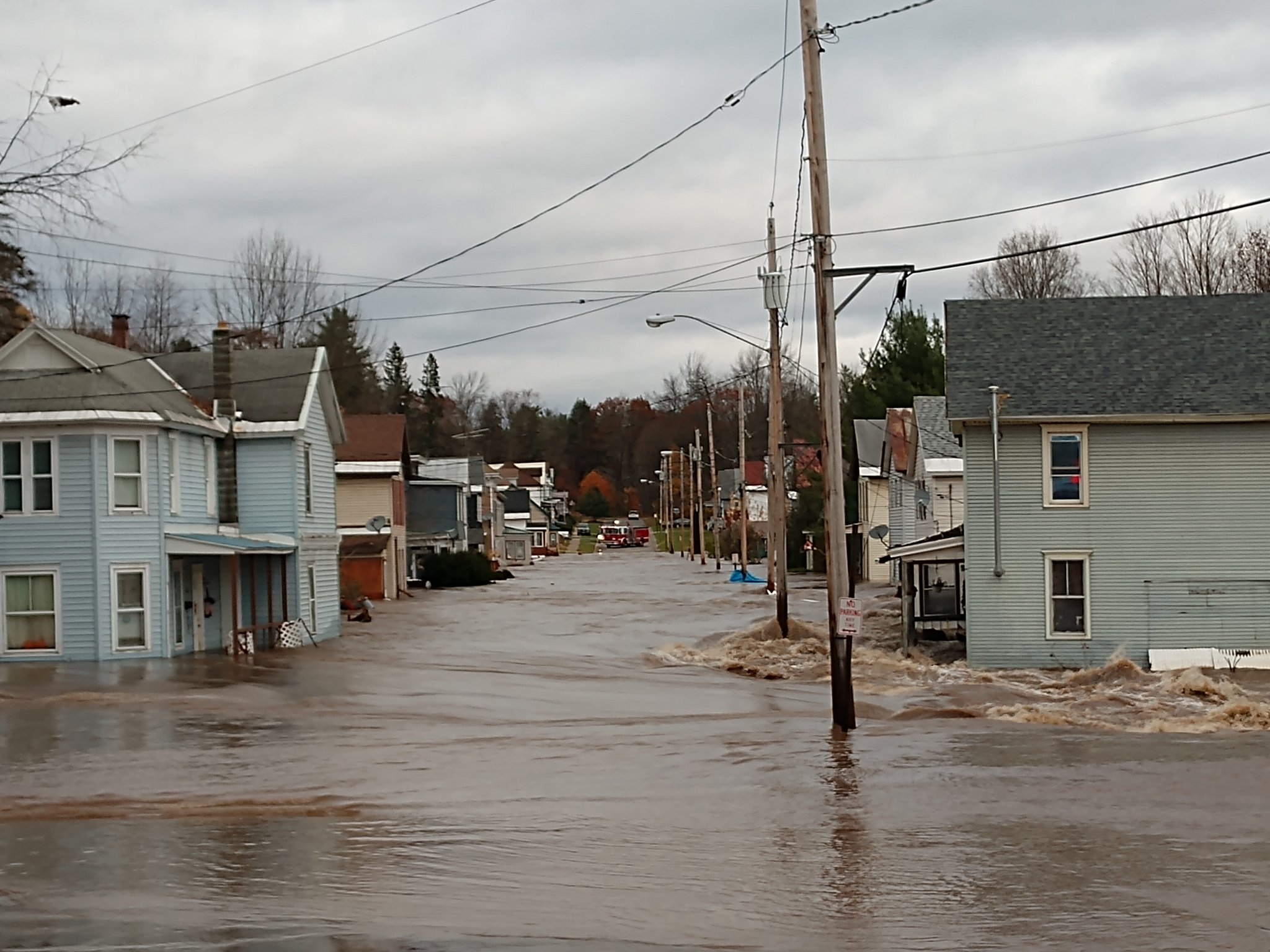
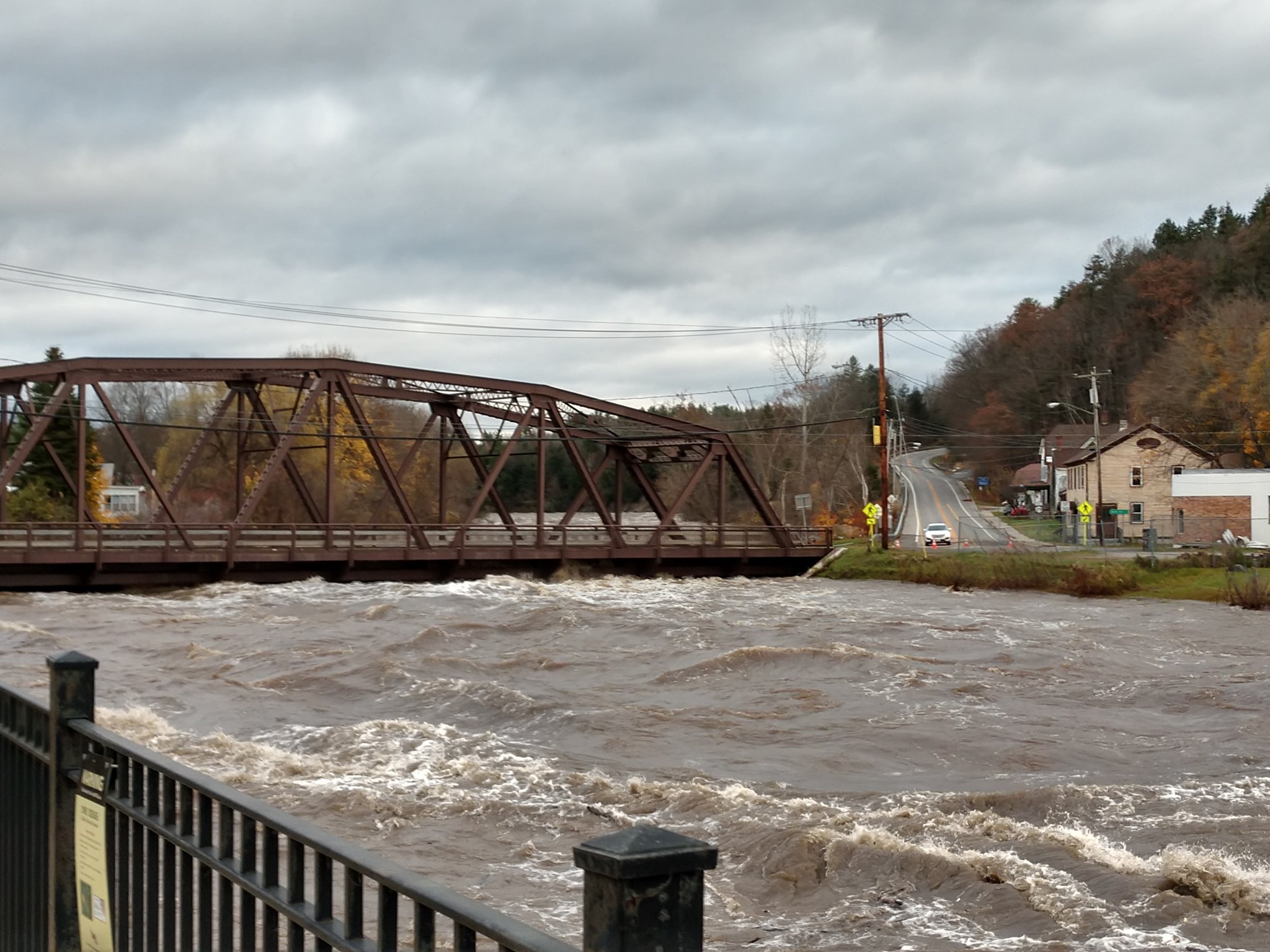
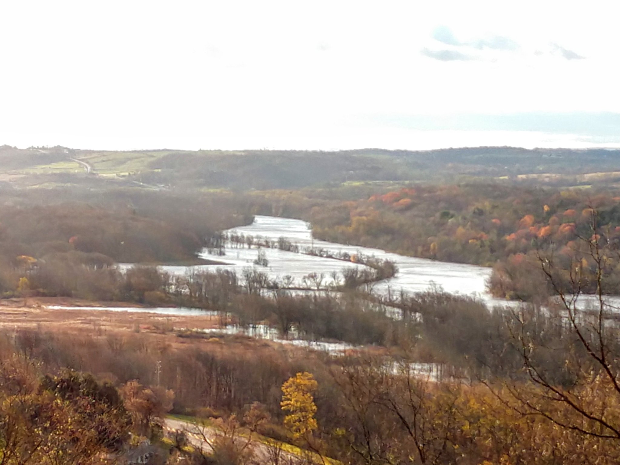
Photos
 |
 |
 |
 |
| Dolgeville, NY (Sarah Condon) |
East Canada Creek at Dolgeville, NY (Sarah Condon) |
Dolgeville, NY (Sarah Condon) |
Route 28 near Newport, NY (Don Peterson) |
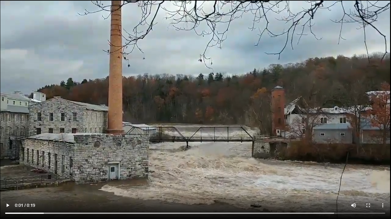
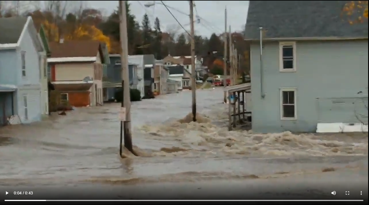
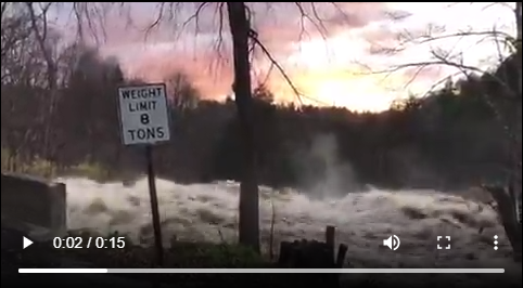
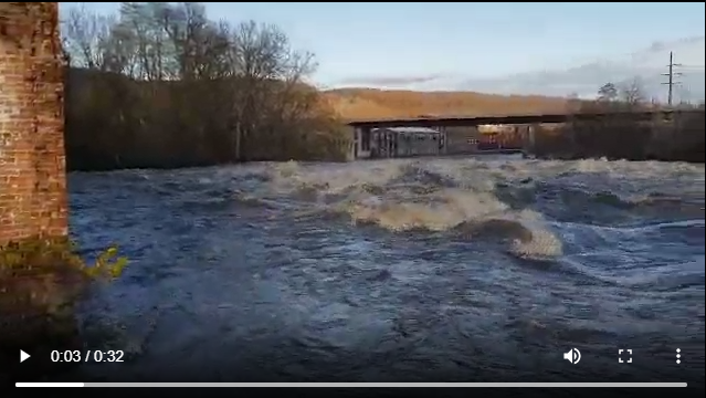
Videos
 |
 |
 |
 |
| Dolgeville, NY (Sarah Condon) |
Dolgeville, NY (Sarah Condon) |
Spruce Creek, Herkimer County, NY (Matt Mackie) |
Mohawk River, Little Falls, NY (Don Peterson) |
Radar
KENX radar loop from 4 pm October 31 to 4 am November 1
 |
Storm Reports
PRELIMINARY LOCAL STORM REPORT...SUMMARY
NATIONAL WEATHER SERVICE ALBANY NY
449 PM EDT FRI NOV 01 2019

..TIME...   ...EVENT...      ...CITY LOCATION...     ...LAT.LON...
..DATE...   ....MAG....      ..COUNTY LOCATION..ST.. ...SOURCE....
            ..REMARKS..

0535 PM     NON-TSTM WND DMG 2 WNW HALFMOON          42.87N  73.77W
10/31/2019                   SARATOGA           NY   SOCIAL MEDIA

            TREES DOWN.

0537 PM     NON-TSTM WND DMG WEST SAND LAKE          42.64N  73.61W
10/31/2019                   RENSSELAER         NY   PUBLIC

            TREES DOWN

0900 PM     NON-TSTM WND DMG 1 WNW HIGH FALLS        41.83N  74.14W
10/31/2019                   ULSTER             NY   SOCIAL MEDIA

            TREE AND WIRES DOWN.

1000 PM     NON-TSTM WND DMG HARTFORD                43.38N  73.39W
10/31/2019                   WASHINGTON         NY   EMERGENCY MNGR

            SEVERAL REPORTS OF TREES DOWN ACROSS THE COUNTY

0130 AM     NON-TSTM WND DMG 2 NW EAST SCHODACK      42.58N  73.67W
11/01/2019                   RENSSELAER         NY   TRAINED SPOTTER

            TWO LARGE TREES WERE DOWNED AT MILLER ROAD AND PALMER
            ROAD

0410 AM     NON-TSTM WND DMG ROTTERDAM JUNCTION      42.87N  74.05W
11/01/2019                   SCHENECTADY        NY   LAW ENFORCEMENT

            UTILITY POLE DOWN AT THE JUNCTION OF BURDECK ST. AND
            DUNNSVILLE RD.

0545 AM     NON-TSTM WND DMG 1 WNW MANCHESTER CENTER 43.18N  73.06W
11/01/2019                   BENNINGTON         VT   FIRE DEPT/RESCUE

            LARGE TREE DOWN BLOCKING ENTRANCE TO RIVERSIDE
            TOWNHOUSES ROAD.

0630 AM     NON-TSTM WND DMG WILTON                  43.17N  73.74W
11/01/2019                   SARATOGA           NY   SOCIAL MEDIA

            BALLARD RD A TREE CAME DOWN AND SNAPPED UTILITY POLE.

0645 AM     NON-TSTM WND DMG POUGHQUAG               41.61N  73.68W
11/01/2019                   DUTCHESS           NY   DEPT OF HIGHWAYS

            NY 216, ROAD CLOSURE BETWEEN NY 55 AND CR-7 WITH DOWN
            TREE.

0742 AM     NON-TSTM WND GST 2 SSW SALISBURY         43.11N  74.86W
11/01/2019  M50 MPH          HERKIMER           NY   TRAINED SPOTTER

0820 AM     NON-TSTM WND GST SPRAKERS                42.87N  74.51W
11/01/2019  M53 MPH          MONTGOMERY         NY   NYSM

0830 AM     NON-TSTM WND GST HERKIMER                43.04N  75.01W
11/01/2019  M60 MPH          HERKIMER           NY   NYSM

0900 AM     NON-TSTM WND DMG 1 SW ILION              43.00N  75.05W
11/01/2019                   HERKIMER           NY   TRAINED SPOTTER

            LARGE TREE DOWN, BLOCKING SOUTH 3RD AVE

0912 AM     NON-TSTM WND DMG 3 W GANSEVOORT          43.20N  73.70W
11/01/2019                   SARATOGA           NY   LAW ENFORCEMENT

            ONE LANE OF I-87 NORTHBOUND WAS CLOSED BETWEEN EXITS 16
            AND 17 DUE TO A DOWNED TREE

0914 AM     NON-TSTM WND DMG 1 WNW ALBANY            42.66N  73.79W
11/01/2019                   ALBANY             NY   SOCIAL MEDIA

            LARGE TREE DOWNED ON MYRTLE AVENUE BETWEEN WEST
            LAWRENCE AND SOUTH MAIN

0915 AM     NON-TSTM WND DMG 1 N NEW BALTIMORE       42.45N  73.79W
11/01/2019                   GREENE             NY   DEPT OF HIGHWAYS

            ROUTE 144 IS CLOSED AT SHADY HARBOR ROAD DUE TO DOWNED
            WIRES

0929 AM     NON-TSTM WND DMG 2 SSE WILTON            43.14N  73.73W
11/01/2019                   SARATOGA           NY   LAW ENFORCEMENT

            TWO LANES OF I-87 SOUTHBOUND BETWEEN EXITS 15 AND 16
            WERE CLOSED DUE TO A DOWNED TREE

0942 AM     NON-TSTM WND DMG 2 NNW TRIBES HILL       42.98N  74.31W
11/01/2019                   MONTGOMERY         NY   PUBLIC

            PART OF A METAL ROOF WAS BLOWN OFF OF A RESIDENCE

1035 AM     NON-TSTM WND GST HESSVILLE               42.86N  74.72W
11/01/2019  M63 MPH          MONTGOMERY         NY   MESONET

1112 AM     NON-TSTM WND DMG 2 SW NORFOLK            41.97N  73.23W
11/01/2019                   LITCHFIELD         CT   CO-OP OBSERVER

            NUMEROUS TREES AND WIRES DOWN

1113 AM     NON-TSTM WND DMG 2 W FONDA               42.96N  74.41W
11/01/2019                   MONTGOMERY         NY   DEPT OF HIGHWAYS

            ROUTE 334 IS CLOSED BETWEEN VEDDER ROAD AND COMMONS
            ROAD DUE TO A DOWNED TREE

1144 AM     NON-TSTM WND DMG 4 NW INDIAN LAKE        43.82N  74.34W
11/01/2019                   HAMILTON           NY   DEPT OF HIGHWAYS

            ROUTE 28 IS CLOSED IN BOTH DIRECTIONS BETWEEN INDIAN
            LAKE AND BLUE MOUNTAIN LAKE DUE TO DOWNED TREES AND
            POWERLINES

1210 PM     NON-TSTM WND GST SPRAKERS                42.87N  74.51W
11/01/2019  M50 MPH          MONTGOMERY         NY   NYSM

1245 PM     NON-TSTM WND DMG 4 WSW BALLSTON SPA      42.99N  73.92W
11/01/2019                   SARATOGA           NY   DEPT OF HIGHWAYS

            ROUTE 67 WAS CLOSED AT HOP CITY ROAD DUE TO DOWNED
            WIRES

1251 PM     NON-TSTM WND DMG 2 NNE ROCK CITY FALLS   43.09N  73.90W
11/01/2019                   SARATOGA           NY   NEWSPAPER

            TREES DOWN ON WIRES RESULTING IN ROAD CLOSURE AT MIDDLE
            GROVE ROAD AND SAND HILL ROAD

0115 PM     NON-TSTM WND DMG 2 WNW SARATOGA SPRINGS  43.08N  73.82W
11/01/2019                   SARATOGA           NY   DEPT OF HIGHWAYS

            DOWN WIRES ON ROUTE 29 E/W BETWEEN BUFF ROAD AND PINE
            ROAD.

0130 PM     NON-TSTM WND DMG 2 ENE JOHNSTOWN         43.02N  74.34W
11/01/2019                   FULTON             NY   DEPT OF HIGHWAYS

            ROUTE 29 IS CLOSED IN BOTH DIRECTIONS BETWEEN HARRISON
            STREET AND HALES MILLS ROAD.

0200 PM     NON-TSTM WND DMG 2 NNE PORTER CORNERS    43.18N  73.86W
11/01/2019                   SARATOGA           NY   DEPT OF HIGHWAYS

            ROUTE 9N BETWEEN HOLMES ROAD AND SPIER FALLS ROAD HAS
            ALL LANES BLOCKED DUE TO DOWN TREE AND WIRES

0230 PM     NON-TSTM WND DMG 2 WNW WARRENSBURG       43.52N  73.81W
11/01/2019                   WARREN             NY   TRAINED SPOTTER

            A TREE AND WIRES WERE DOWNED ACROSS GOLF COURSE ROAD,
            BLOCKING TRAFFIC
Public Information Statement
National Weather Service Albany NY
435 PM EDT Fri Nov 1 2019

...HIGHEST WIND REPORTS...

Location                     Speed     Time/Date       Provider

...Connecticut...

...Litchfield County...
Winsted (WEATHERSTEM)        38 MPH    0240 AM 11/01   MESOWEST
Watertown                    36 MPH    0130 AM 11/01   CWOP
Torrington                   35 MPH    0230 AM 11/01   CWOP
Torrington                   34 MPH    1135 PM 10/31   CWOP
New Hartford                 32 MPH    0229 AM 11/01   CWOP
Winsted                      32 MPH    0231 AM 11/01   CWOP
Bantam                       31 MPH    0200 AM 11/01   CWOP
4 NNE Kent                   31 MPH    0155 AM 11/01   AWS
Plymouth                     30 MPH    1047 PM 10/31   CWOP

...Massachusetts...

...Berkshire County...
Harriman Airport             53 MPH    1228 AM 11/01   ASOS
Pittsfield Municipal Airport 51 MPH    0516 AM 11/01   ASOS
Adams                        50 MPH    1131 AM 11/01   CWOP
Peru                         48 MPH    1145 PM 10/31   CWOP
Williamstown                 39 MPH    1215 PM 11/01   CWOP
Lanesboro                    32 MPH    1115 AM 11/01   CWOP

...New York...

...Albany County...
Voorheesville                55 MPH    0155 AM 11/01   NYSM
Albany Intl Ap               51 MPH    1132 AM 11/01   ASOS
Medusa                       41 MPH    1125 AM 11/01   NYSM
2 W Guilderland              37 MPH    1115 AM 11/01   RAWS
Voorheesville                35 MPH    0932 AM 11/01   CWOP
Colonie                      35 MPH    0946 AM 11/01   CWOP

...Columbia County...
Copake                       52 MPH    0130 AM 11/01   NYSM
Kinderhook                   46 MPH    0945 PM 10/31   NYSM
Claverack                    44 MPH    1115 PM 10/31   CWOP
Chatham                      35 MPH    0944 AM 11/01   CWOP

...Dutchess County...
Hudson Valley Regional Airpo 53 MPH    0141 AM 11/01   ASOS
Beacon                       50 MPH    1110 PM 10/31   NYSM
3 NNE Beacon                 48 MPH    0207 AM 11/01   RAWS
Bannerman Island             48 MPH    0138 AM 11/01   WXFLOW
Red Hook                     45 MPH    1025 PM 10/31   NYSM
Dover Plains                 43 MPH    0205 AM 11/01   NYSM
Lagrangeville                35 MPH    0952 PM 10/31   CWOP

...Fulton County...
2 ESE Johnstown              51 MPH    0917 AM 11/01   AWOS
Oppenheim                    49 MPH    0645 AM 11/01   NYSM
Broadalbin                   46 MPH    0716 AM 11/01   CWOP
Perth                        32 MPH    0717 AM 11/01   CWOP

...Greene County...
Tannersville                 45 MPH    0815 PM 10/31   NYSM
Halcott Center               36 MPH    0930 AM 11/01   CWOP
Hunter                       36 MPH    0847 AM 11/01   CWOP

...Hamilton County...
Piseco                       52 MPH    0630 AM 11/01   NYSM
Indian Lake                  42 MPH    0505 AM 11/01   NYSM
6 ENE Piseco                 36 MPH    0700 AM 11/01   RAWS
Inlet                        35 MPH    0542 AM 11/01   CWOP
Raquette Lake                30 MPH    0345 AM 11/01   NYSM

...Herkimer County...
Herkimer                     60 MPH    0830 AM 11/01   NYSM
Cold Brook                   48 MPH    0625 AM 11/01   NYSM
Big Moose                    38 MPH    0530 AM 11/01   CWOP
Dolgeville                   37 MPH    0831 AM 11/01   CWOP
Old Forge                    36 MPH    0605 AM 11/01   NYSM
Little Falls                 30 MPH    1028 AM 11/01   CWOP

...Montgomery County...
Hessville                    63 MPH    1035 AM 11/01   CWOP
Sprakers                     53 MPH    0820 AM 11/01   NYSM
Johnstown                    50 MPH    1025 AM 11/01   NYSM

...Rensselaer County...
Brunswick                    49 MPH    1210 AM 11/01   CWOP
Schaghticoke                 48 MPH    1035 AM 11/01   NYSM
Stephentown                  47 MPH    1115 PM 10/31   NYSM
Schodack                     46 MPH    0155 AM 11/01   NYSM
Hoosick Falls                44 MPH    0946 AM 11/01   CWOP
Eagle Mills                  43 MPH    1127 PM 10/31   CWOP

...Saratoga County...
Edinburg                     54 MPH    0715 AM 11/01   NYSM
Ballston Spa                 46 MPH    0755 AM 11/01   NYSM
Schuylerville                45 MPH    0935 AM 11/01   NYSM
Saratoga Springs             44 MPH    1001 AM 11/01   CWOP
Clifton Park                 44 MPH    0130 AM 11/01   CWOP
1 NW The Saratoga Battllefie 39 MPH    0138 AM 11/01   RAWS
Kingsbury                    36 MPH    0131 AM 11/01   CWOP
Ballston Lake                30 MPH    0940 AM 11/01   CWOP

...Schenectady County...
Duanesburg                   51 MPH    1115 AM 11/01   NYSM
Schenectady                  43 MPH    0120 AM 11/01   CWOP
East Glenville               43 MPH    1054 AM 11/01   AWOS

...Schoharie County...
Cobleskill                   47 MPH    0102 AM 11/01   CWOP
Cobleskill                   45 MPH    0820 AM 11/01   NYSM

...Ulster County...
Wallkill                     50 MPH    0125 AM 11/01   NYSM
Willow                       46 MPH    0731 AM 11/01   CWOP
Claryville                   45 MPH    0610 PM 10/31   NYSM
6.1 W Rosendale Village (WEA 41 MPH    1250 AM 11/01   MESOWEST
Kingston                     38 MPH    0150 AM 11/01   CWOP
High Falls                   37 MPH    0130 AM 11/01   NYSM
Kingston                     34 MPH    0110 AM 11/01   CWOP
3 SSW Tivoli                 34 MPH    1142 PM 10/31   NDBC
Port Ewen                    33 MPH    0150 AM 11/01   CWOP
2 ESE Fleischmanns           31 MPH    0411 AM 11/01   RAWS
New Paltz                    30 MPH    0113 AM 11/01   CWOP

...Warren County...
Chestertown                  47 MPH    0645 AM 11/01   NYSM
Floyd Bennett Memorial Airpo 46 MPH    0914 AM 11/01   ASOS
Glens Falls                  44 MPH    0655 AM 11/01   NYSM
Lake Luzerne                 39 MPH    0731 AM 11/01   CWOP
Hartford                     32 MPH    0155 AM 11/01   CWOP
Queensbury                   30 MPH    0850 AM 11/01   CWOP

...Washington County...
5 S Whitehall                46 MPH    0925 AM 11/01   NYSM
Cambridge                    41 MPH    0632 AM 11/01   CWOP
Fort Edward                  36 MPH    1118 PM 10/31   CWOP
Granville                    33 MPH    0952 AM 11/01   CWOP

...Vermont...

...Bennington County...
1.6 NE Old Bennington (VTRAN 47 MPH    0150 AM 11/01   MESOWEST
Bennington State Airport     44 MPH    1111 AM 11/01   ASOS
3.1 W Woodford State Park (V 44 MPH    1040 AM 11/01   MESOWEST
3.5 W Peru (VTRANS)          41 MPH    0700 AM 11/01   MESOWEST
Stratton Mountain            38 MPH    0947 AM 11/01   CWOP
2.2 W Manchester (VTWAC)     35 MPH    1240 AM 11/01   MESOWEST
Woodford State Park          35 MPH    1002 AM 11/01   RAWS

...Windham County...
Rockingham                   53 MPH    0411 AM 11/01   CWOP
West Dover                   52 MPH    0916 AM 11/01   CWOP
E.Dummerston                 37 MPH    0205 AM 11/01   CWOP
Wilmington                   36 MPH    1059 AM 11/01   CWOP
3.4 S Brattleboro (VTRANS)   33 MPH    1240 PM 11/01   MESOWEST
1.8 E Townshend (VTWAC)      31 MPH    1140 AM 11/01   MESOWEST
&&
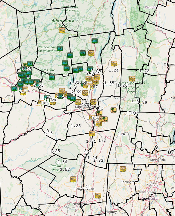
Rain Reports
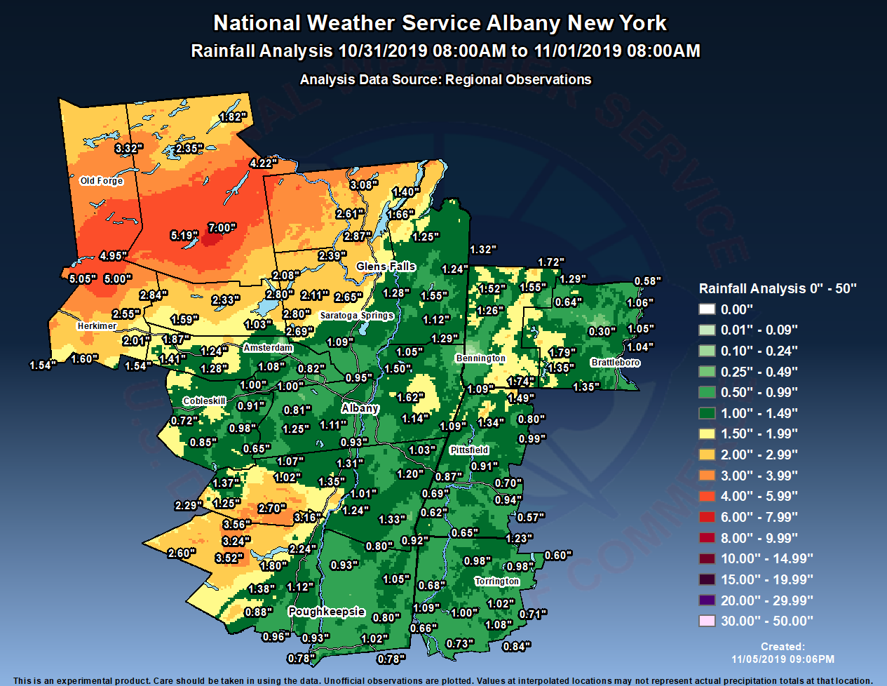
Public Information Statement
Spotter Reports
National Weather Service Albany NY
358 PM EST Tue Nov 05 2019

The following are unofficial observations taken during the past 131
hours for the storm that has been affecting our region. Appreciation
is extended to highway departments, cooperative observers, Skywarn
spotters and media for these reports. This summary also is available
on our home page at weather.gov/albany

********************STORM TOTAL RAINFALL********************

LOCATION          STORM TOTAL     TIME/DATE   COMMENTS
                     RAINFALL           OF
                     /INCHES/   MEASUREMENT

MASSACHUSETTS

...Berkshire County...
   Clarksburg            1.74   525 AM 11/01  WeatherNet6
   Pittsfield            1.40   948 AM 11/01  Storm total rainfall
   Lenoxdale             0.91   300 AM 11/01  Trained Spotter
   Savoy                 0.80  1107 PM 10/31  WeatherNet6

NEW YORK

...Albany County...
   1 W Albany            1.36   600 AM 11/01  Trained Spotter
   South Berne           1.25   737 AM 11/01  WeatherNet6
   Colonie               0.96   711 AM 11/01  WeatherNet6

...Columbia County...
   Taghkanic             1.33   549 AM 11/01  WeatherNet6
   Livingston            1.24   802 AM 11/01  WeatherNet6
   1 WSW Chatham         1.20   839 AM 11/01  Storm total rainfall
   Ancramdale            0.92   549 AM 11/01  WeatherNet6

...Dutchess County...
   Poughkeepsie          1.21   806 AM 11/01  WeatherNet6

...Fulton County...
   Broadalbin            2.80   855 AM 11/01  WeatherNet6
   Fishhouse             2.80   543 AM 11/01  WeatherNet6

...Greene County...
   Catskill              2.40   602 AM 11/01  WeatherNet6
   1 S Coxsackie         1.31  1036 AM 11/01  Storm total rainfall
   Halcott Center        1.25   442 AM 11/01  WeatherNet6

...Herkimer County...
   3 ENE Newport         5.00  1025 AM 11/01  Public
   Ohio                  4.95   325 AM 11/01  Trained Spotter
   1 ENE Ilion           3.77   904 AM 11/01  Amateur Radio
   Dolgeville            2.55  1100 AM 11/01  Trained Spotter

...Montgomery County...
   Fonda                 2.10   611 AM 11/01  WeatherNet6
   Fort Plain            1.87   644 AM 11/01  WeatherNet6
   Hessville             1.86   615 AM 11/01  WeatherNet6
   Palatine Bridge       1.24   546 AM 11/01  WeatherNet6
   Amsterdam             0.72   630 AM 11/01  WeatherNet6

...Rensselaer County...
   Speigletown           1.50   602 AM 11/01  WeatherNet6

...Saratoga County...
   Galway                2.69   552 AM 11/01  WeatherNet6
   Lake Desolation       2.11   749 AM 11/01  WeatherNet6
   Saratoga Springs      1.87   811 AM 11/01  WeatherNet6

...Schenectady County...
   Duanesburg            1.00   614 AM 11/01  WeatherNet6
   Schenectady           0.82   833 AM 11/01  WeatherNet6
   1 NNE Hawthorne Hill  0.61   824 AM 11/01  NWS Employee

...Schoharie County...
   Middleburgh           0.98   658 AM 11/01  WeatherNet6
   North Blenheim        0.85   748 AM 11/01  WeatherNet6
   Richmondville         0.72   350 AM 11/01  WeatherNet6

...Ulster County...
   Phoenicia             3.56   603 AM 11/01  WeatherNet6
   West Shokan           3.52   808 AM 11/01  WeatherNet6

...Warren County...
   Queensbury            3.05   606 AM 11/01  WeatherNet6
   Lake Luzerne          2.80   537 AM 11/01  WeatherNet6

...Washington County...
   Greenwhich            1.55   740 AM 11/01  WeatherNet6
   Hebron                1.24   649 AM 11/01  WeatherNet6
   Hudson Falls          0.75   440 AM 11/01  WeatherNet6

VERMONT

...Bennington County...
   Landgrove             1.72   624 AM 11/01  WeatherNet6
   Woodford              1.50   735 AM 11/01  WeatherNet6
   West Arlington        1.26   552 AM 11/01  WeatherNet6

...Windham County...
   Wilmington            1.79   544 AM 11/01  WeatherNet6


**********************24 HOUR RAINFALL**********************

LOCATION              24 HOUR     TIME/DATE   COMMENTS
                     RAINFALL           OF
                     /INCHES/   MEASUREMENT

CONNECTICUT

...Litchfield County...
   1 NE Colebrook        1.23   700 AM 11/01  CoCoRaHS
   2 WNW Warren          1.09   700 AM 11/01  CoCoRaHS
   1 S Watertown         1.08   705 AM 11/01  CoCoRaHS
   1 SSE Torrington      1.08   700 AM 11/01  CoCoRaHS
   1.6 NE Thomaston      1.06   630 AM 11/01  HADS
   2 NNE Litchfield      1.02   730 AM 11/01  CoCoRaHS
   Bantam                1.00   815 AM 11/01  CWOP
   Winsted               0.98   816 AM 11/01  CWOP
   New Hartford          0.98   403 AM 11/01  CWOP
   Torrington            0.88   820 AM 11/01  CWOP
   Watertown             0.84   818 AM 11/01  CWOP
   3 SW New Hartford Ce  0.82   700 AM 11/01  CoCoRaHS
   Bakersville           0.82   700 AM 11/01  Co-Op Observer
   0.9 NW Woodbury Cent  0.73   815 AM 11/01  HADS
   Plymouth              0.71   817 AM 11/01  CWOP
   4 NNE Kent            0.68   825 AM 11/01  AWS
   Litchfield            0.66   825 AM 11/01  AWS
   Canaan                0.65   823 AM 11/01  CWOP
   Barkhamsted           0.60   825 AM 11/01  CWOP

MASSACHUSETTS

...Berkshire County...
   Clarksburg            1.49   824 AM 11/01  CWOP
   Adams                 1.34   824 AM 11/01  AWS
   Pittsfield Municipal  1.13   754 AM 11/01  ASOS
   3 WNW North Adams     1.09   700 AM 11/01  CoCoRaHS
   4 SE Lee              1.03   730 AM 11/01  CoCoRaHS
   Pittsfield            1.00   824 AM 11/01  CWOP
   Peru                  0.99   821 AM 11/01  CWOP
   6 SSW Becket          0.94   700 AM 11/01  CoCoRaHS
   Harriman Airport      0.94   752 AM 11/01  ASOS
   NNE Stockbridge       0.87   600 AM 11/01  CoCoRaHS
   Williamstown          0.82   815 AM 11/01  CWOP
   1 NW Pittsfield       0.76   824 AM 11/01  AWS
   Becket                0.70   817 AM 11/01  CWOP
   3 N Great Barrington  0.69   700 AM 11/01  CoCoRaHS
   2 NNW Pittsfield      0.68   700 AM 11/01  CoCoRaHS
   Lanesboro             0.64   820 AM 11/01  CWOP
   Great Barrington      0.62   816 AM 11/01  CWOP
   East Otis             0.57   815 AM 11/01  CWOP

NEW YORK

...Albany County...
   Alcove Reservoir      1.35   740 AM 11/01  Co-Op Observer
   3 S Clarksville       1.23   740 AM 11/01  CoCoRaHS
   NWS Albany            1.17   800 AM 11/01  CoCoRaHS
   2 WNW Albany          1.15   700 AM 11/01  CoCoRaHS
   Albany                1.12   815 AM 11/01  CWOP
   1 S Delmar            1.11   700 AM 11/01  CoCoRaHS
   ESE Albany            1.07   635 AM 11/01  CoCoRaHS
   Cohoes                1.03   816 AM 11/01  CWOP
   Glenmont              0.95   821 AM 11/01  CWOP
   Albany Intl Ap        0.95   751 AM 11/01  ASOS
   1 NNW Ravena          0.93   757 AM 11/01  CoCoRaHS
   2 NNW Rensselaervill  0.92   700 AM 11/01  CoCoRaHS
   1 SW Albany           0.91   700 AM 11/01  CoCoRaHS
   3 SW Glenmont         0.82   700 AM 11/01  CoCoRaHS
   Voorheesville         0.81   825 AM 11/01  NYSM
   2 W Guilderland       0.79   815 AM 11/01  RAWS
   Colonie               0.79   816 AM 11/01  CWOP
   3 SSW Altamont        0.74   655 AM 11/01  CoCoRaHS
   3 SW Altamont         0.73   700 AM 11/01  CoCoRaHS
   Medusa                0.65   825 AM 11/01  NYSM


...Columbia County...
   1 SSW Livingston      1.24   750 AM 11/01  CoCoRaHS
   Kinderhook            1.07   825 AM 11/01  NYSM
   Hudson                1.01   817 AM 11/01  CWOP
   2 NNW Valatie         0.98   700 AM 11/01  CoCoRaHS
   3 N Valatie           0.97   700 AM 11/01  CoCoRaHS
   Ghent                 0.86   820 AM 11/01  CWOP
   N Ancramdale          0.80   700 AM 11/01  CoCoRaHS
   Chatham               0.57   824 AM 11/01  CWOP
   Copake                0.56   825 AM 11/01  NYSM

...Dutchess County...
   5 SE Poughkeepsie     1.20   700 AM 11/01  CoCoRaHS
   3 SE Millbrook        1.14   700 AM 11/01  CoCoRaHS
   3 NE Millbrook        1.05   600 AM 11/01  CoCoRaHS
   3 NE Hopewell Juncti  1.02   600 AM 11/01  CoCoRaHS
   2 ESE Wappingers Fal  0.93   715 AM 11/01  CoCoRaHS
   5 SE Rhinebeck        0.93   700 AM 11/01  CoCoRaHS
   Clinton Corners       0.90   515 AM 11/01  Co-Op Observer
   2.3 W Millbrook       0.87   700 AM 11/01  HADS
   Dover Plains          0.84   825 AM 11/01  NYSM
   3 NE Lagrangeville    0.80   700 AM 11/01  CoCoRaHS
   1 SE Beacon           0.78   700 AM 11/01  CoCoRaHS
   Holmes                0.78   823 AM 11/01  CWOP
   Hudson Valley Region  0.77   753 AM 11/01  ASOS
   Lagrangeville         0.69  1021 PM 10/31  CWOP
   4 SSE Poughkeepsie    0.68   500 AM 11/01  CoCoRaHS
   Red Hook              0.67   825 AM 11/01  NYSM
   2.0 E Wingdale        0.66   630 AM 11/01  HADS
   1 NNE Red Hook        0.66   700 AM 11/01  CoCoRaHS
   Pleasant Valley       0.65   816 AM 11/01  CWOP
   5 S Poughkeepsie      0.64   900 AM 11/01  CoCoRaHS
   3 NNE Beacon          0.64   807 AM 11/01  RAWS
   Fairview              0.61   824 AM 10/31  CWOP
   Hopewell Junction     0.55   816 AM 11/01  CWOP
   Salt Point            0.54   820 AM 11/01  CWOP

...Fulton County...
   Gloversville 7nw      2.33   800 AM 11/01  Co-Op Observer
   1 N Northville        2.08   656 AM 11/01  CoCoRaHS
   5 ESE Broadalbin      1.73   900 AM 11/01  CoCoRaHS
   Northville            1.62   830 AM 11/01  Co-Op Observer
   Oppenheim             1.59   825 AM 11/01  NYSM
   Perth                 1.03   717 AM 11/01  CWOP

...Greene County...
   3.2 SE Tannersville   3.80   800 AM 11/01  MESOWEST
   5 SSE Tannersville    3.16   730 AM 11/01  CoCoRaHS
   Tannersville          2.70   825 AM 11/01  NYSM
   East Jewett           2.43   640 AM 11/01  Co-Op Observer
   Halcott Center        2.29   815 AM 11/01  CWOP
   Palenville            1.97   822 AM 11/01  CWOP
   2 N Lexington         1.37   700 AM 11/01  CoCoRaHS
   2 NNW Athens          1.35   900 AM 11/01  CoCoRaHS
   3 E Freehold          1.14   520 AM 11/01  CoCoRaHS
   1 E Greenville        1.07   500 AM 11/01  CoCoRaHS
   Freehold              1.02   815 AM 11/01  CWOP
   Prattsville           0.99   820 AM 11/01  CWOP
   SE New Baltimore      0.86   700 AM 11/01  CoCoRaHS

...Hamilton County...
   10 SSW Speculator     7.00   700 AM 11/01  CoCoRaHS
   Piseco                5.19   825 AM 11/01  NYSM
   Indian Lake           4.22   900 AM 11/01  Co-Op Observer
   Raquette Lake         2.35   825 AM 11/01  NYSM
   SSE Long Lake         1.82   700 AM 11/01  CoCoRaHS

...Herkimer County...
   Cold Brook            5.05   825 AM 11/01  NYSM
   Big Moose             3.32   815 AM 11/01  CWOP
   2 NW Salisbury Cente  2.84   600 AM 11/01  CoCoRaHS
   1 WNW Ilion           2.59   600 AM 11/01  CoCoRaHS
   1 WSW Ilion           2.55   700 AM 11/01  CoCoRaHS
   Herkimer              2.49   825 AM 11/01  NYSM
   2 NW Dolgeville       2.19   700 AM 11/01  CoCoRaHS
   4 E Jordanville       2.01   800 AM 11/01  CoCoRaHS
   Little Falls          1.81   758 AM 11/01  CWOP
   Chepachet Loc On Rt   1.60  1000 AM 11/01  Co-Op Observer
   4.4 NE West Winfield  1.60   800 AM 11/01  MESOWEST
   Dolgeville            1.54   815 AM 11/01  CWOP
   West Winfield         1.54   825 AM 11/01  AWS

...Montgomery County...
   Johnstown             1.58   825 AM 11/01  NYSM
   2 WSW Hessville       1.54   600 AM 11/01  CoCoRaHS
   Hessville             1.41   815 AM 11/01  CWOP
   1 NNW Amsterdam       1.33   945 AM 11/01  CoCoRaHS
   Sprakers              1.28   825 AM 11/01  NYSM
   SE Fort Plain         1.15   700 AM 11/01  CoCoRaHS

...Rensselaer County...
   Eagle Mills           1.62   822 AM 11/01  CWOP
   7 NE Troy             1.40   700 AM 11/01  CoCoRaHS
   Buskirk               1.29   745 AM 11/01  Co-Op Observer
   3 SW Wyantskill       1.20   703 AM 11/01  CoCoRaHS
   Brunswick             1.15   815 AM 11/01  CWOP
   1 WNW Averill Park    1.14   800 AM 11/01  CoCoRaHS
   Stephentown           1.09   825 AM 11/01  NYSM
   2 NNE Troy            1.07   700 AM 11/01  CoCoRaHS
   Schaghticoke          1.05   825 AM 11/01  NYSM
   4 ESE Nassau          1.03   741 AM 11/01  CoCoRaHS
   1 E Troy              1.02   700 AM 11/01  CoCoRaHS
   Hoosick Falls         1.00   821 AM 11/01  CWOP
   East Greenbush        0.84   816 AM 11/01  CWOP
   Schodack              0.68   825 AM 11/01  NYSM
   Troy                  0.64   825 AM 11/01  AWS

...Saratoga County...
   2 W Greenfield Cente  2.65   755 AM 11/01  CoCoRaHS
   Sacandaga Lake        2.39   800 AM 11/01  Co-Op Observer
   Edinburg              2.34   825 AM 11/01  NYSM
   1 WNW Gansevoort      1.28   600 AM 11/01  CoCoRaHS
   1 S Saratoga Springs  1.11   600 AM 11/01  CoCoRaHS
   4 NE Round Lake       1.10   700 AM 11/01  CoCoRaHS
   2 NNE Round Lake      1.09   700 AM 11/01  CoCoRaHS
   1 WNW Country Knolls  1.09   800 AM 11/01  CoCoRaHS
   Ballston Spa          1.02   825 AM 11/01  NYSM
   1 NW The Saratoga Ba  1.01   738 AM 11/01  RAWS
   3 N Round Lake        1.00   645 AM 11/01  CoCoRaHS
   Schuylerville         0.97   825 AM 11/01  NYSM
   3 WSW Mechanicville   0.93   800 AM 11/01  CoCoRaHS
   3 ESE Ballston Spa    0.89   745 AM 11/01  CoCoRaHS
   Ballston Lake         0.88   824 AM 11/01  CWOP
   3 S Clifton Park      0.87   600 AM 11/01  CoCoRaHS
   2 W Clifton Park      0.78   700 AM 11/01  CoCoRaHS

...Schenectady County...
   Duanesburg            1.19   825 AM 11/01  NYSM
   4 SSW Pattersonville  1.08   800 AM 11/01  CoCoRaHS
   Delanson 2ne          1.00   700 AM 11/01  Co-Op Observer
   2 N Niskayuna         0.68   700 AM 11/01  CoCoRaHS
   3 E Schenectady       0.66   900 AM 11/01  CoCoRaHS
   S Niskayuna           0.63   700 AM 11/01  CoCoRaHS
   2 ESE Rotterdam       0.42   825 AM 11/01  AWS
   1 NW Rotterdam        0.35   720 AM 11/01  CoCoRaHS

...Schoharie County...
   Cobleskill            1.84   711 AM 11/01  Co-Op Observer
   4 NNE Cobleskill      1.15   700 AM 11/01  CoCoRaHS
   Schoharie             0.91   715 AM 11/01  Co-Op Observer

...Ulster County...
   Phoenicia             3.24   600 AM 11/01  Co-Op Observer
   Claryville            2.60   825 AM 11/01  NYSM
   Willow                2.32   817 AM 11/01  CWOP
   Slide Mountain        2.29   747 AM 11/01  Co-Op Observer
   S West Hurley         2.24   800 AM 11/01  CoCoRaHS
   2 ESE Fleischmanns    1.83   811 AM 11/01  RAWS
   East Ashokan          1.80   745 AM 11/01  UCOOP
   Kerhonkson            1.65   815 AM 11/01  CWOP
   2 S Hurley            1.59   700 AM 11/01  CoCoRaHS
   Sleepy Hollow         1.45   445 AM 11/01  CWOP
   1 WNW Stone Ridge     1.38   650 AM 11/01  CoCoRaHS
   High Falls            1.12   825 AM 11/01  NYSM
   Kingston              1.09  1250 AM 11/01  CWOP
   SW Highland           1.07   700 AM 11/01  CoCoRaHS
   2 WNW Rosendale Vill  1.04   700 AM 11/01  CoCoRaHS
   1 NNE Esopus          0.97   700 AM 11/01  CoCoRaHS
   4 E Wallkill          0.96   700 AM 11/01  CoCoRaHS
   1 NNW Ulster Park     0.89   730 AM 11/01  CoCoRaHS
   1 WNW Gardiner        0.88   800 AM 11/01  CoCoRaHS
   Wallkill              0.85   825 AM 11/01  NYSM
   Port Ewen             0.83   820 AM 11/01  CWOP
   1 SSE Kingston        0.74   700 AM 11/01  CoCoRaHS

...Warren County...
   Chestertown           3.08   825 AM 11/01  NYSM
   1 N Lake George       2.87   600 AM 11/01  CoCoRaHS
   2 WNW Warrensburg     2.61   800 AM 11/01  CoCoRaHS
   Queensbury            1.97   820 AM 11/01  CWOP
   3 E Queensbury        1.81   700 AM 11/01  CoCoRaHS
   Lake Luzerne          1.75   816 AM 11/01  CWOP
   Bolton Landing        1.66   817 AM 11/01  CWOP
   Floyd Bennett Memori  1.42   753 AM 11/01  ASOS
   Hartford              1.40   822 AM 11/01  CWOP
   Glens Falls           1.38   825 AM 11/01  NYSM
   5 ESE Lake George     1.00   730 AM 11/01  CoCoRaHS

...Washington County...
   Granville             1.32   822 AM 11/01  CWOP
   Fort Ann              1.25   823 AM 11/01  CWOP
   10 SW Granville       1.15   702 AM 11/01  CoCoRaHS
   5 S Whitehall         1.13   825 AM 11/01  NYSM
   Cambridge             1.12   816 AM 11/01  CWOP
   Fort Edward           0.95   818 AM 11/01  CWOP
   Greenwich             0.82   820 AM 11/01  CWOP
   Brooklyn              0.36   816 AM 11/01  CWOP

VERMONT

...Bennington County...
   Stamford              1.59   820 AM 11/01  CWOP
   3 ENE Manchester      1.55   700 AM 11/01  CoCoRaHS
   2.2 W Manchester (VT  1.52   818 AM 11/01  MESOWEST
   Woodford State Park   1.50   802 AM 11/01  RAWS
   1 NNE Landgrove       1.29   615 AM 11/01  CoCoRaHS
   4.4 E Woodford State  0.74   700 AM 11/01  HADS
   Stratton Mountain     0.64   816 AM 11/01  CWOP
   Bennington State Air  0.12  1154 PM 10/31  ASOS
   3 W Bennington        0.11   817 AM 10/31  CoCoRaHS

...Windham County...
   West Dover            1.71   816 AM 11/01  CWOP
   Wilmington            1.35   824 AM 11/01  CWOP
   SE West Halifax       1.35   736 AM 11/01  CoCoRaHS
   1 WNW Wilmington      1.30   542 AM 11/01  CoCoRaHS
   5.6 W West Brattlebo  1.17   800 AM 11/01  Co-Op Observer
   6 NW Westminster      1.06   700 AM 11/01  CoCoRaHS
   2 WNW Putney          1.05   700 AM 11/01  CoCoRaHS
   E.Dummerston          1.04   820 AM 11/01  CWOP
   Westminster           0.88   221 AM 11/01  CWOP
   1 S Brattleboro       0.78   700 AM 11/01  CoCoRaHS
   1 NNE Rockingham      0.58   630 AM 11/01  CoCoRaHS
   1.8 E Townshend (VTW  0.30   815 AM 11/01  MESOWEST

&&
 |
Media use of NWS Web News Stories is encouraged! Please acknowledge the NWS as the source of any news information accessed from this site. |
|

