Overview

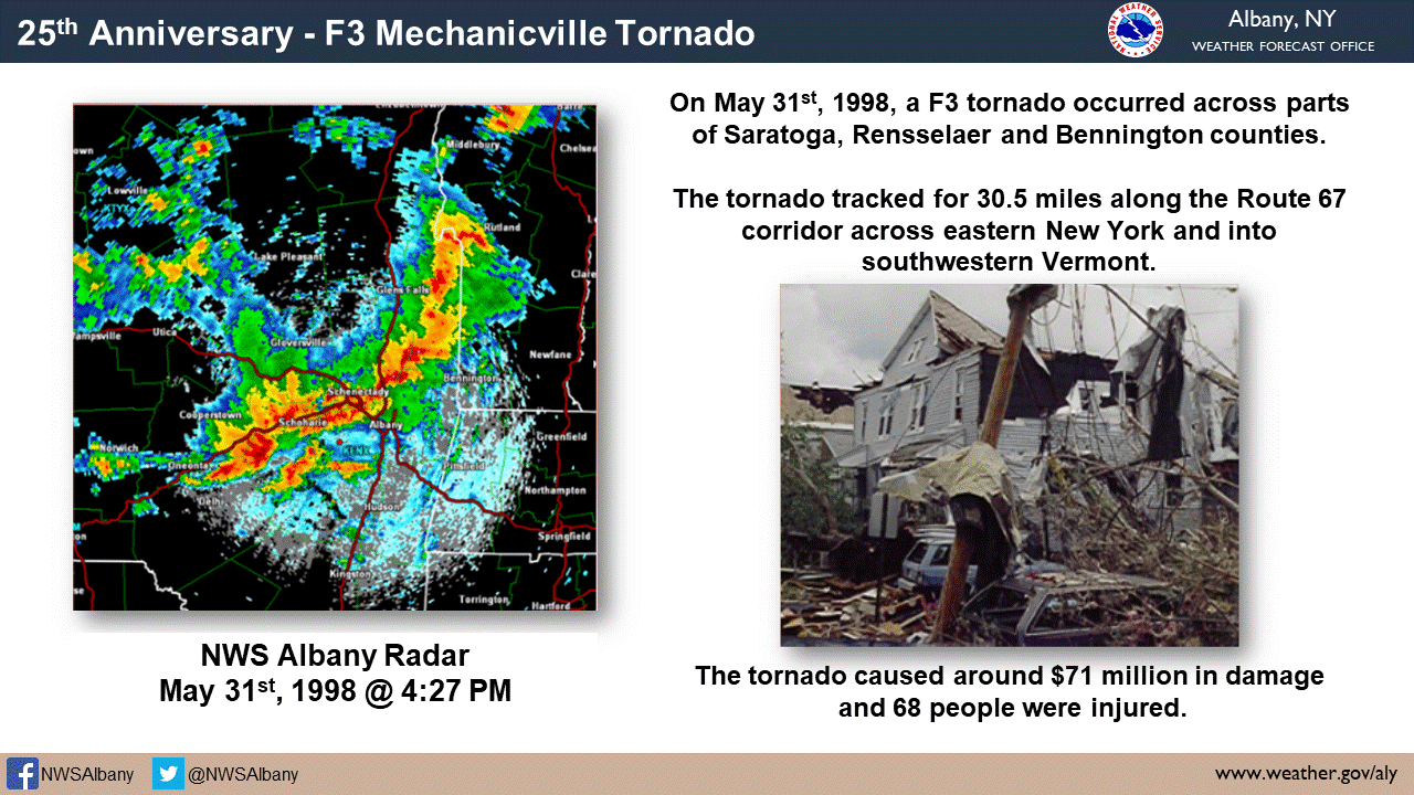
On Sunday, May 31, 1998, a severe weather outbreak occurred across the northeast United States. The severe thunderstorms produced 20 tornadoes within a two hour drive of Albany, NY, along with hundreds of damaging wind and large hail reports. This was an extreme severe weather event by Northeastern standards, similar to events that occur in the Great Plains of the United States. This outbreak is locally known for the F3 Mechanicville, NY tornado, but there were three additional tornadoes confirmed in the Albany forecast area.
There were five fatalities and 127 injuries associated with 32 tornadoes across the Northeast. Additionally, there were 264 reports of wind damage and 84 reports of hail (3/4" or larger). Sixty-eight people were injured in the Mechanicville tornado alone. It is believed that accurate and timely severe weather outlooks, tornado watches and tornado warnings contributed to no lives being lost in the Albany forecast area. Many people who survived the tornadoes, when interviewed, stated that they had received the watches and warnings and took shelter when they saw the storms approach.
Severe weather was anticipated the day before by the Albany National Weather Service (NWS) office, who issued statements on Saturday afternoon outlining the potential for significant severe weather the next day. Additionally, a Special Weather Statement (SPS) was issued on Sunday at 10:17 AM emphasizing the event, with a follow-up SPS issued at noon highlighting “This is a dangerous situation.” This would be the second large severe weather event in three days. The local area was hit by severe weather on May 29, 1998.
On May 31, 1998, the Albany NWS forecast area was in a “High Risk” for severe weather as defined by the NWS Storm Prediction Center (SPC) in Norman, OK. SPC has been issuing severe weather outlooks since the mid-1950s. This is the only time the Albany forecast area has been put in a “High Risk”. It hadn’t happened before, it hasn’t happed since. At 2:45 PM, SPC issued a tornado watch for most of New York.
About half of the office staff (12 people) was on duty that Sunday. This included an electronic technician to help ensure equipment functionality, and someone to operate amateur radio and provide emergency communications. The NWS office in Albany lost both power and telephone communications at times during the event. The NOAA Weather Radio in New Scotland, NY was knocked off the air by storms. Some EAS activation was done by local television and radio stations. Some warnings were relayed to county EOCs by amateur radio due to communication outages.
Straight line wind damage occurred in most of NWS Albany's County Warning Area. The severe storms resulted in tens of millions of dollars in damage to homes and businesses, and extensive forest damage. Power was out to over 130,000 customers at the storm's peak, while 12,000 were without power for over three days. Cloud to ground lightning rates over the region reached 15,000 strikes per hour and fires started by lightning were reported. Despite all the severe storms rumbling around, no flash floods were reported in the NWS Albany forecast area.
A lot has changed since that day in 1998. At that time, the NWS issued severe weather warnings by county. The NWS no longer issues warnings by county, but rather by polygons that are much smaller, and based on the size, speed and movement of storms. Pathcasts (lists of towns in the storm’s path) were manually created by a forecaster looking at a map in 1998. Today, the pathcasts are software generated once a forecaster outlines the polygon where severe weather is expected.
In 1998, the warning process could take many minutes since the forecaster had to manually type out the warning after the warning decision was made. Today, software allows the NWS forecaster to issue a warning in less than a minute from the time the warning decision is made. Finally, in 1998, the warnings had to be manually read and recorded for playback on NOAA Weather Radio. Today, software translates NWS warning text into speech for airplay.
The devastating impacts from the severe weather of May 31, 1998 underscore the need for everyone to have a severe weather safety plan. Whether at work, school, home, place of worship, or outdoors, you should know how you will receive severe weather warnings, and where you will shelter when severe weather approaches. For more information on severe weather preparedness, visit www.weather.gov/safety/tornado
Please see the link below for a comprehensive summary of the event: Natural Disaster Survey Report - NWS Albany
 |
| Storm Prediction Center Day 1 Convective Outlook. Only High Risk ever issued for the Northeast US. |
Photos & Video:
 |
 |
 |
 |
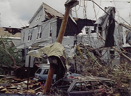
| Aerial imagery of the Mechanicville tornado damage | Aerial imagery of the Mechanicville tornado damage | Aerial imagery of the Mechanicville tornado damage | Tornado damage |
 |
 |
 |
 |
| Tornado damage | Tornado damage | Tornado damage | Tornado damage |
Thanks to...
Carl Cerniglia...various damage photographs.
Mark McKinley...various damage photographs.
John Quinlan...Storm information and various damage photographs.
Dick Westergard
Dan O'Brien...New York State Emergency Management Office
New York State Emergency Management Office
All NYS Emergency Management Office photographs were supplied with support from...
Aerial Images...Landcare Aviation, INC.
Aerial Sensor...TASC/EMERGE
Photographs produced by Mark McKinley were generated with aerial support from the New York State Police Aviation Unit, Arrangement courtesy of the New York State Department of Environmental Conservation.
Radar:
 |
 |
.5.png) |
| Loop from KENX radar starting 9:17 am 31 May 1998 and ending 1:00 am 1 June 1998 | Storm-relative velocity image from KENX radar at 2022Z (4:22 pm EDT) 31 May 1998 showing the storm rotation as the tornado touched down | Normalized rotation (Nrot) image from KENX radar at 2023Z (4:23 pm EDT) 31 May 1998 showing the storm rotation as the tornado touched down |
Storm Reports
 |
 |
 |
 |
| All severe weather reports | Severe hail reports | Severe wind reports | Tornado reports |
 |
| Mechanicville tornado track map |
|
Preliminary damage report. This is not an all inclusive list, rather it is a general list of damage reports received by NWSFO Albany. (This list was last updated at 700 pm June 3, 1998)
COUNTY TIME Location - Severe event
Herkimer (S) 338 Frankfort,Dolgeville, Cedarville - trees down
Montgomery 342 Fonda - trees down
Montgomery 342 Fonda - trees down 344 Amsterdam -tornado west
Herkimer (S) 345 Mohawk - wind damage
Fulton 345 Gloversville - Trees and wires down 3 houses / 2 cars damaged, some may have occurred in later storms
Saratoga 415 Milton - 1" hail 416 Mechanicville - 60 mph 425-435 Stillwater - F2 - F3 Ttornado Extensive structural damage 28 injured sent to hospital 40 injured treated on scene 20 homes destroyed 25 homes with severe damage 10+ with moderate damage 420 Saratoga Springs - 1.75' hail 425-435 Mechanicville - tornado 435 Malta, Ballston Spa .75" hail
Schoharie (N) 410 Schoharie Village 430 Blenheim - trees down (time aprx) 432 Middleburg - wind damage
Albany 438 Bethlehem Center - wind damage 440 Albany Airport - 82 mph gust 450 Colonie - wind damage
Schenectady 450 Rotterdam - trees down 450 Schenecaty - trees down
Washington 430 Southern portion - trees down 445-500 White Creek - F1 Tornado
Bennington 432 Arlington - trees down 455 N Bennington - F1 Tornado 505 Bennington - trees down
Rennselaer (N) 445 East of Hoosic Falls- F2 Tornado at NY and VT border 450 Schaghticoke - trees down Trailers flipped over Damage also at Hoosick, Pittstown 500 Brunswick - trees down 505 E. Green bush -trees down
Albany 438 Bethlehem Ctr. - wind damage 440 Albany Airport - gusts 82 mph 440-445 Colonie - F0 Tornado 2 mile path length. Discontiuous wind damage. Funnel cloud obsevered by FAA personel. 450 Colonie - trees down
Schoharie 430 Blenheim - trees down
Schenectady 450 Rotterdam - trees down 450 Schenectady - tree down
Saratoga 450 Mechanicville - trees down
Greene 500 Greenville - quarter size hail
Windam 542 Brattleboro - tornado observed
Columbia 510 Stuyvesant - 0.75" hail 510 Kinderhook- trees down 520 Chatham - trees down 526 Niverville - tree on house 531 Stuyvesant -1" hail
Berkshire 545 Pittsfield - 1.75" hail
Rensselaer 535 Nassua - trees down
Herkimer 625 Mohawk - trees down
Fulton 630 Gloversville - Trees and wires down
Montgomery 620-630 Root, Ames, Fort Plain Fonda, Amsterdam, Charleston - trees down
Schoharie 635 Richmonville - roof damage 645 Blenheim - dime size hail 647 Breekabeen
Saratoga 708 Mechanicville - wind damage
Schenecrady 700 Duanesburg - trees down
Albany 716 Guilderland - tornado observed
708 Clarksville - tree down 711 New Scotland
Greene 733 Greenville - tree d 745 Catskill - dime size hail
Rennselaer 725 East Schodack - F2 Tornado 4 miles of tree damage. 2 barns destroyed 2 homes with severe damage 742 Stephentown - wind damage
Bennington 715 W Shaftsbury - 0.88 - 1.75" hail
Washington 735 Greenwich - numerous trees down
Albany 730 New Scotland - trees down
Schoharie 735 Schoharie- widespread damage
Ulster 800 Saugerties and other locations Wires down Time uncertain
Windham 755 Brattleboro - wind damage
Columbia 830 Hillsdale - wind damage
Berkshire 755 N.Adams - gusts 70 mph 800 Great Barrington - hail 803 Pittsfield - wind damage
Greene 823 Catskill - 0.75" hail 827 Catskill - 1.0" hail
Bennington 830 Pownal, Shaftsbury - trees down
Ulster 900 Gardiner and other locations Wires down - time uncertain
Columbia 900 Copake - trees down
Berkshire 940 South Lee - wind damage
Ulster 900 Gardiner and other locations Wires down - time uncertain
Dutchess 900-1000 Widespread reports of downed trees, including towns of Rhinebeck, Red Hook, Clinton Corners, Stanford, Wappingers
Litchfield 950 New Milford - large limbs down |
Environment
Meteorological Background by Warren Snyder, former NWS Albany Science and Operations OfficerIn the morning hours Sunday, May 31, 1998 a warm front moved rapidly north across New York and Western New England. During the day, upper level divergence rapidly increased, the 850 hPa jet increased to over 50 kts, and helicity values increased to 500 to 800 m^2 sec^-2 in the highly sheared environment. Low level moisture increased rapidly as dew points rose from 8C to 22C during the day, resulting in rapid atmospheric destabilization. During the morning of the 31st, a derecho moved across southern Ontario and decayed as it moved into the Adirondacks. It established boundaries which focused later convection. During the afternoon a cold front pressed south into western New York and a series of lines of thunderstorms formed ahead of it. Thunderstorms developed explosively as they moved east across the region. Several of these storms became tornadic. The most long lived tornadic thunderstorm produced a series of tornadoes starting with an F3 tornado that moved across the Saratoga County communities of Stillwater and Mechanicville, and moved into the Rensselaer County town of Schaghticoke. The tornado continued east across Hoosick Falls into the Washington County town of White Creek and into Bennington County, Vermont. It was mainly an F2 and skipped occasionally from Rensselaer county into Vermont. An F2 tornado occurred in East Schodack, while an F1 tornado occurred across the Albany International Airport. The tornadoes of May 31, 1998 were caused by scattered supercell thunderstorms along a squall line in a highly sheared environment. Most of the other severe thunderstorm wind damage was associated a series of squall lines which moved across the region at speeds of 40 to 60 mph.
Research: |
 |
Media use of NWS Web News Stories is encouraged! Please acknowledge the NWS as the source of any news information accessed from this site. |
 |