Back-to-back powerful Pacific storm systems to impact the Pacific Northwest and northern California through the end of this week with heavy rain, flooding, strong winds, and higher elevation mountain snow. A strong, long-duration atmospheric river will accompany the Pacific storms, bringing excessive rainfall and flash flooding to southwest Oregon and northwest California through the week. Read More >
Wakefield, VA
Weather Forecast Office
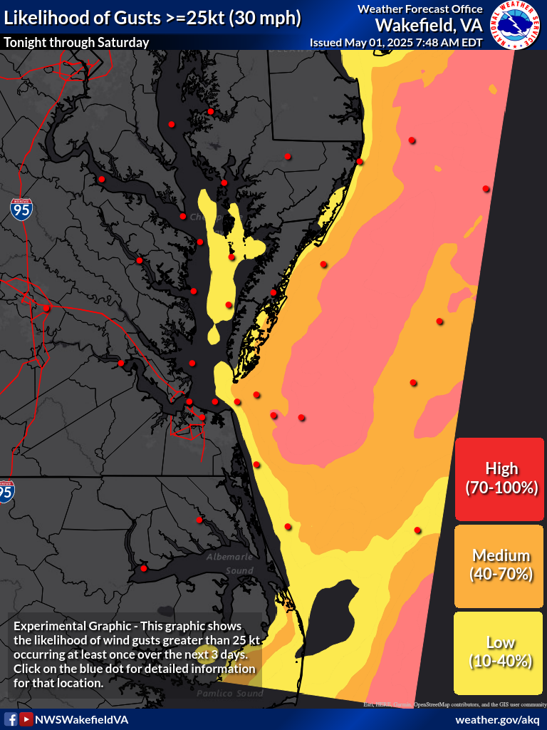
25kt Likelihood 34kt Likelihood 43kt Likelihood 48kt Likelihood Forecast Wind Gust High End Wind Gust |
|
Directions Hover over the buttons above to get the map of your choice. Then click on your point of interest to get complete wind and wind gust probabilities for that location, as well as the point forecast. Wind Gust Likelihood Levels Low Likelihood (10-40%)
A low likelihood of a certain wind gust implies that there is small chance for a certain wind gust (generally a 1 in 10 to 4 in 10 chance). Persons who may experience impacts at certain wind thresholds may want to prepare for these type of wind speeds in case they do occur. Medium Likelihood (40-70%)
A medium likelihood of a certain wind gust implies that there is a better chance for a certain wind gust (generally a 4 in 10 to 7 in 10 chance). Persons should prepare for impacts from these type of gusts as someone in the area may experience wind speeds at or above this threshold. High Likelihood (70-100%)
A high likelihood of a certain wind gust implies that there is at least a 7 in 10 chance for wind gusts of above the certain value. Persons should prepare for impacts from these type of gusts as someone in the area will likely see wind speeds at or above this threshold. |
CURRENT CONDITIONS
LAND OBSERVATIONS HOURLY
RIVER LEVEL SUMMARY
GIS MARINE REPORTS
MARINE OBSERVATIONS
EARTHQUAKE MONITOR
TIDES NEXT FEW DAYS
FORECASTS
Zone Forecast
Marine Forecast
Fire Weather Forecast
Air Quality Forecast
River Level Forecast
Summer Rip Current Forecast
Graphical Rain Totals
Core TEXT Products
RSS/XML
MODEL-DATA
NCEP Models
ENSO
Nearshore Wave Prediction System (NWPS)
Meso Analysis
Local WRF Model
Statistical Models
SAFETY/EDUCATION
Awareness Weeks Messages
CoCoRAHS
SkyWarn
Storm Ready
Weather Ready Nation
Brochures
Safety
WindChill Chart
Heat Index
US Dept of Commerce
National Oceanic and Atmospheric Administration
National Weather Service
Wakefield, VA
10009 General Mahone Highway
Wakefield, VA 23888
757-899-4200
Comments? Questions? Please Contact Us.