Overview
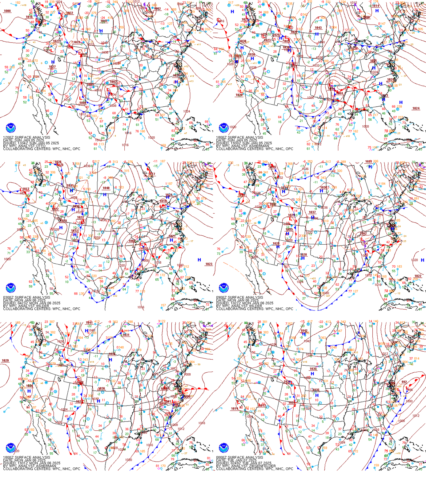
From 1/5 to 1/6, a “Miller B” low pressure system tracked from KY/TN to northern NC, and eventually the secondary low deepened off the VA/NC coast. This was a relatively long duration winter weather event for the Wakefield CWA with three distinct phases.
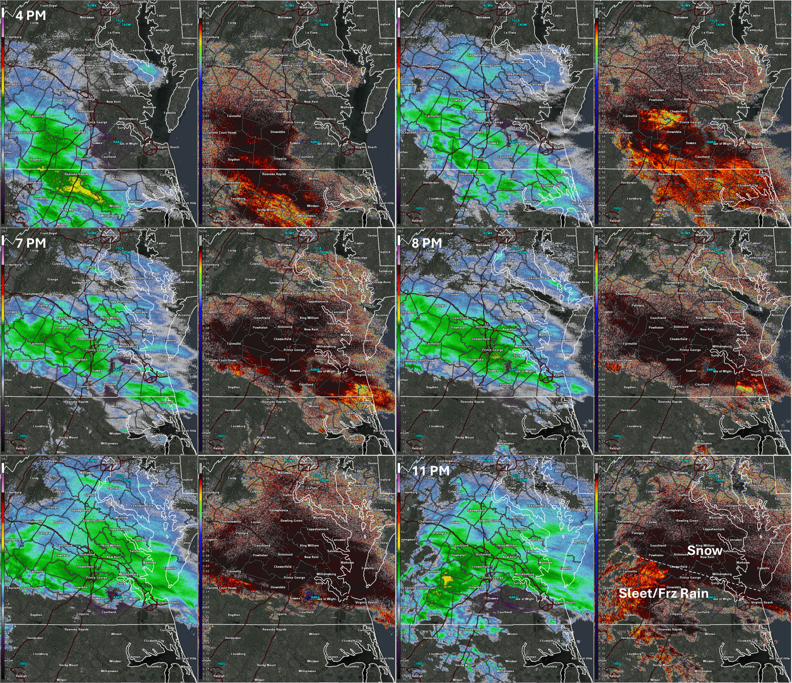
Phase 1 (Late on 1/5): A cold and dry airmass was in place across the area on 1/5. Temperatures across central and SE VA were in the upper 30s to lower 40s with dew points in the single digits. However, there was a decent amount of isentropic ascent/warm air advection aloft from 850 to 500 mb. As a result, this first “phase” of the storm consisted of steady light to moderate snow that targeted areas from the I-64 corridor to south-central VA. With the very dry low-level airmass, temperatures quickly dropped to ~30F after the arrival of the precipitation. This allowed the snow to quickly accumulate and with rates of 1” or so per hour on average, areas from the Piedmont to Richmond Metro to even Prince George County/Williamsburg received 2-3.5” of snow in a 3 hour period before precipitation changed to sleet/freezing rain due to the WAA aloft. 1” of snow fell as far south as a Wakefield-Newport News line. This area of snow shifted to the north and weakened a bit before “Phase 2” of the storm begun.
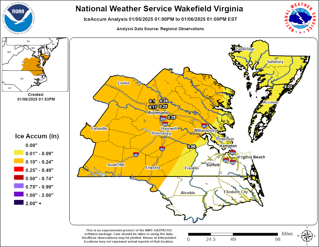
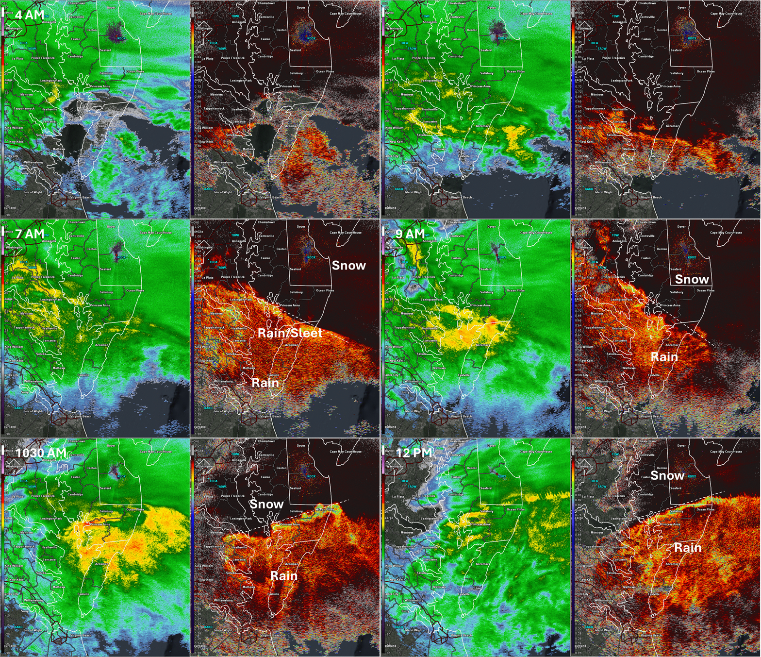
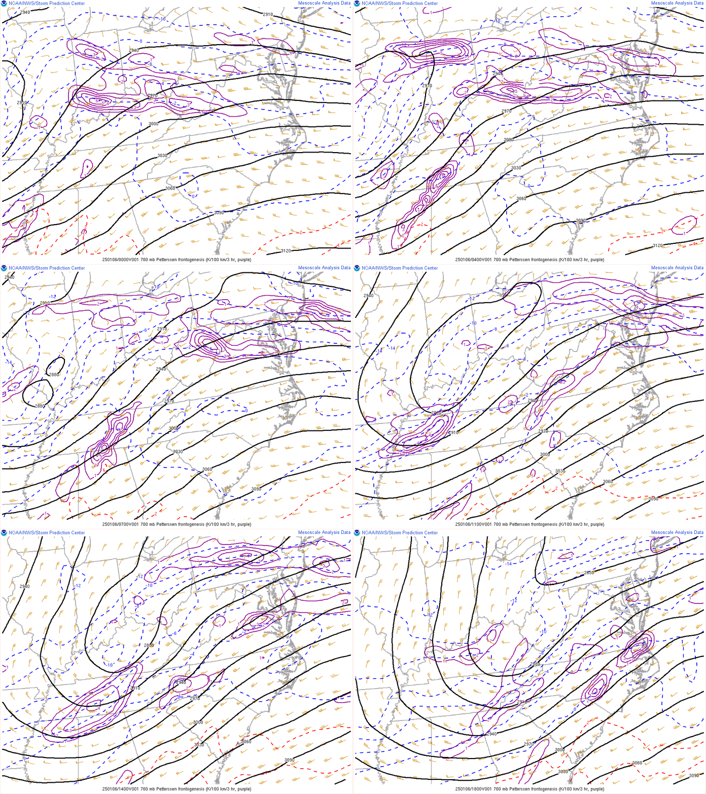
Phase 2 (early morning-midday on 1/6): As the better mid-level forcing for ascent moved northward and a zone of 700mb frontogenesis overspread northern portions of the area, a second area of precipitation tracked across areas along and north of I-64, producing a variety of p-types. Across the central VA Piedmont where the warm nose aloft was strongest, precipitation fell in the form of freezing rain. At one point, ~50% of people were without power in Cumberland County due to the combined effects from snow and freezing rain (ice accretions up to 0.25” were observed). Farther north from Louisa County to the eastern shore, mainly snow was observed. A widespread 4 to 8 inches of snow fell from northern Louisa County to the MD Eastern Shore during the morning on 1/6. In between from Fluvanna County to Tappahannock, a mix of snow and sleet fell, with combined snow and sleet totals of 2 to 4 inches. Impressively, some areas reported sleet totals of 1.5-2” in just a few hours.
Phase 3 (Evening on 1/6): There was a break in the precipitation during the afternoon of 1/6. As the upper level feature tracked across the area (well to the west of surface low pressure deepening offshore), one final round of snow was observed from I-64 northward, producing 0.5-2” of snow as temperatures dropped back into the upper 20s.
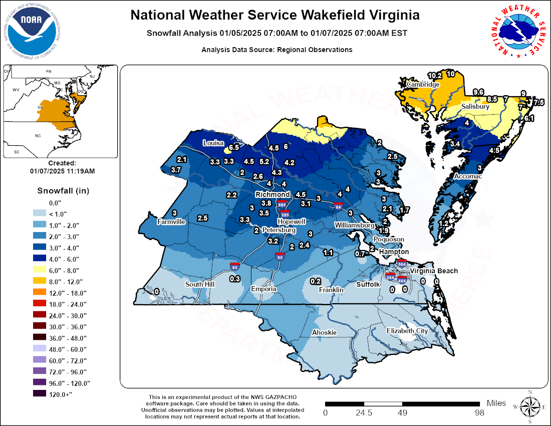
Conclusions: This was the most impactful winter weather event in the Wakefield CWA since January 2022. Storm total snow amounts of ~10 inches were observed in northern Dorchester County, with widespread 3 to 5 inch totals in the Richmond Metro (although snow depth in the Richmond area never got above 3” as precipitation turned to rain during phase 2).
Snow/Ice Maps
 |
 |
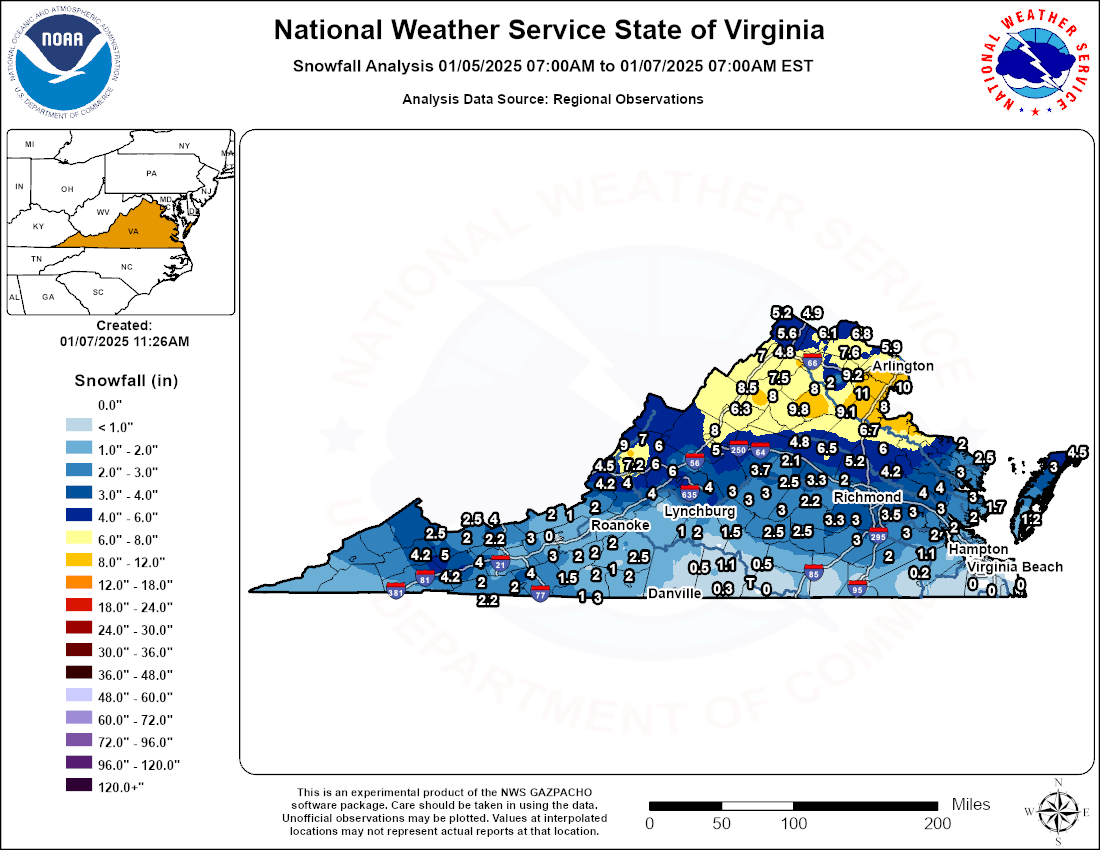 |
| AKQ CWA Snowfall Map | AKQ CWA Ice Accumulation Map | VA State Snowfall Map |
Radar
Selected Radar Loops
 |
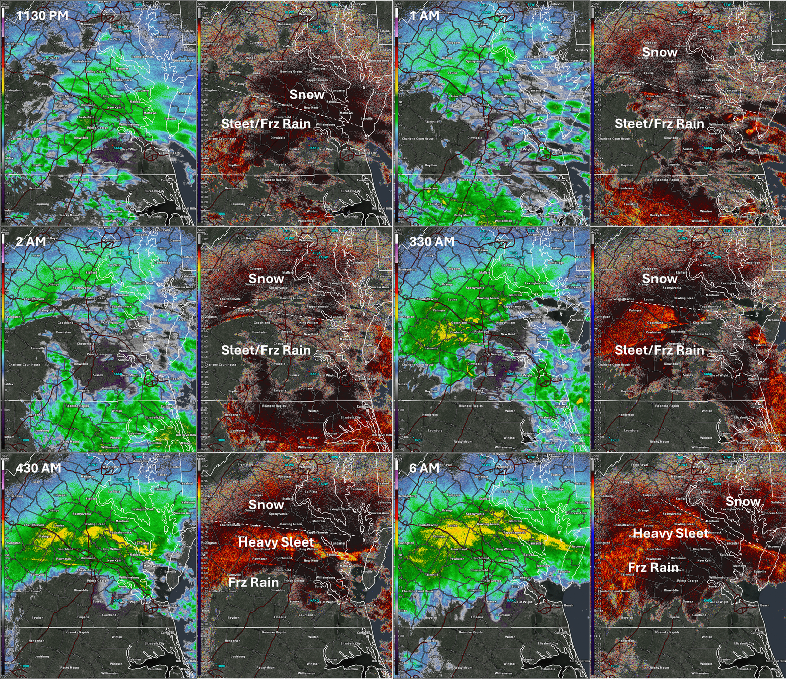 |
| Loop of KAKQ Radar from 4 to 11 PM on 1/5 in 30 min increments (Phase 1 of the event) | Loop of KAKQ Radar from 1130 PM on 1/5 to 6 AM on 1/6 in 30 min increments (Phase 2 of the event) |
 |
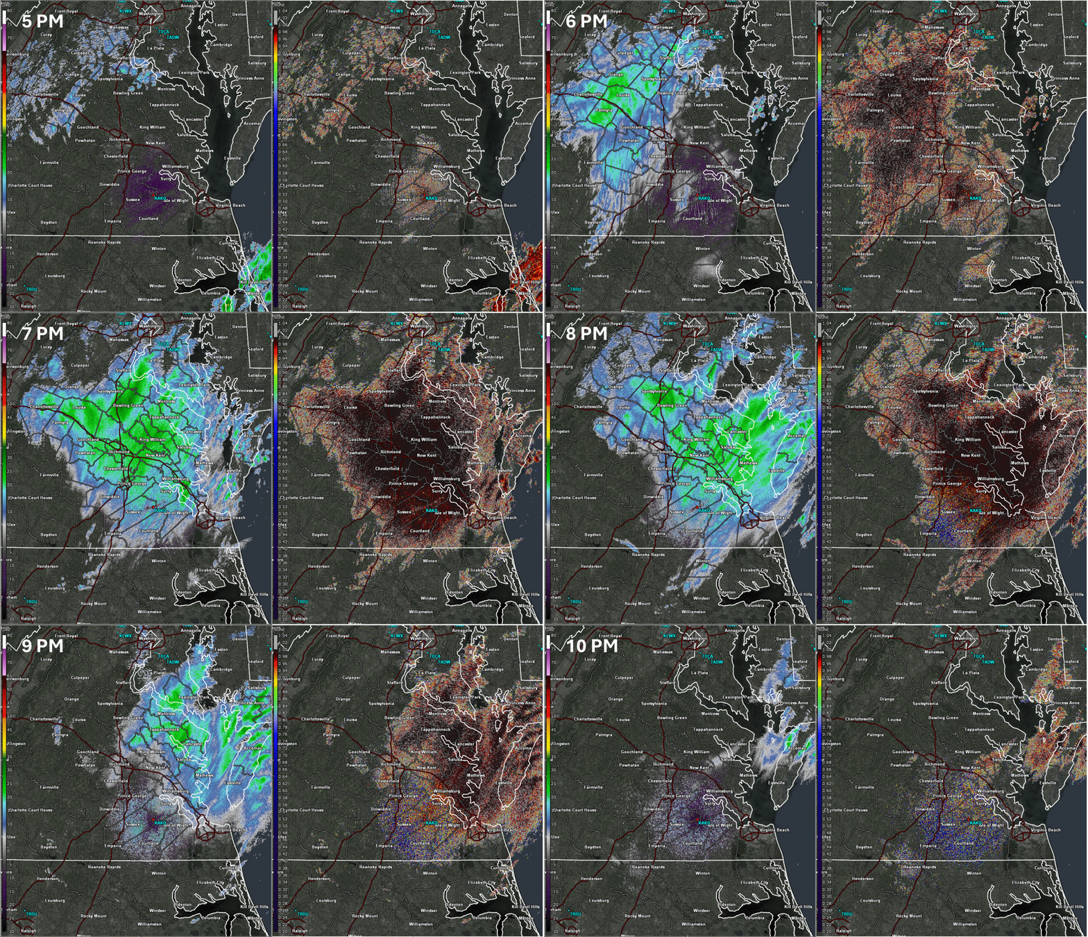 |
| Loop of KDOX Radar from 4 AM to noon on 1/6 in 30 min increments (Phase 2 of the event) | Loop of KAKQ Radar from 5 to 10 PM on 1/6 (Phase 3 of the event) |
Storm Reports
Public Information Statement
National Weather Service Wakefield VA
1039 AM EST Tue Jan 7 2025

...STORM TOTAL SNOWFALL REPORTS...

Location                     Amount    Time/Date       Lat/Lon

...Maryland...

...Dorchester County...
Hurlock 1.9 SW               10.2 in   0700 AM 01/07   38.61N/75.89W
Hurlock                      10.0 in   0138 PM 01/06   38.62N/75.87W

...Somerset County...
Princess Anne 2.1 SSW        4.0 in    1000 AM 01/06   38.17N/75.71W
Crisfield 0.9 ENE            3.4 in    0800 AM 01/06   37.98N/75.84W

...Wicomico County...
Delmar 0.3 ESE               9.6 in    0600 AM 01/07   38.45N/75.57W
2 WNW Parsonsburg            8.5 in    0700 AM 01/07   38.39N/75.50W
Willards                     7.0 in    0108 PM 01/06   38.39N/75.35W

...Worcester County...
Bishopville                  9.0 in    1115 AM 01/06   38.44N/75.19W
Ocean City                   7.5 in    1030 AM 01/06   38.36N/75.07W
1 SSE Berlin                 7.0 in    1100 AM 01/06   38.32N/75.21W
Berlin 3.9 SE                6.1 in    0700 AM 01/07   38.29N/75.16W

...North Carolina...

...Pasquotank County...
Elizabeth City               0.0 in    1121 AM 01/06   36.30N/76.22W

...Virginia...

...Accomack County...
2 NE Atlantic                4.5 in    0100 AM 01/07   37.92N/75.48W
Metompkin 0.9 SE             3.0 in    0700 AM 01/07   37.76N/75.59W

...Amelia County...
Jetersville 3.6 W            2.5 in    0700 AM 01/07   37.30N/78.16W

...Brunswick County...
Lawrenceville 1.2 SSW        0.3 in    0822 AM 01/06   36.74N/77.86W

...Caroline County...
Penola                       6.0 in    0937 PM 01/06   37.96N/77.37W
Ruther Glen 1.7 ENE          4.5 in    0700 AM 01/07   37.94N/77.43W
Hanover 3.0 N                4.2 in    0700 AM 01/07   37.81N/77.36W

...Chesterfield County...
Richmond 7.5 SW              3.8 in    0700 AM 01/07   37.46N/77.58W
Chester 3.3 WSW              3.7 in    0700 AM 01/07   37.33N/77.49W
Matoaca                      3.6 in    0830 AM 01/06   37.23N/77.48W
1 W Bon Air                  3.5 in    1200 AM 01/06   37.52N/77.59W
5 E Moseley                  3.5 in    0700 AM 01/06   37.42N/77.68W
3 NW Pocahontas State Park   3.5 in    1023 PM 01/05   37.42N/77.60W
3.9 SW Beach                 3.3 in    0700 AM 01/06   37.32N/77.65W
Chesterfield 8.5 WSW         3.3 in    0700 AM 01/06   37.33N/77.64W
Midlothian 7.9 S             3.0 in    0730 AM 01/06   37.39N/77.65W

...City of Chesapeake County...
Chesapeake 1.8 NE             T in     0700 AM 01/06   36.69N/76.28W
1 N Chesapeake Airport        T in     0815 AM 01/06   36.68N/76.32W

...City of Colonial Heights County...
1 NE Colonial Heights        3.0 in    1022 AM 01/06   37.28N/77.39W

...City of Emporia County...
1 N Emporia                  0.5 in    0830 AM 01/06   36.71N/77.54W

...City of Hampton County...
Hampton 1.9 NW               2.0 in    0700 AM 01/07   37.07N/76.32W

...City of Newport News County...
1 WNW Menchville             2.0 in    1145 PM 01/05   37.10N/76.55W
Newport News 3.3 E           2.0 in    0500 AM 01/07   37.08N/76.45W
1 WSW Beaconsdale            1.7 in    0700 AM 01/07   37.05N/76.50W

...City of Norfolk County...
1 SE Norview                 0.2 in    0900 AM 01/07   36.87N/76.23W

...City of Petersburg County...
1 W Petersburg               2.5 in    1243 AM 01/06   37.21N/77.41W

...City of Poquoson County...
Poquoson 6.1 WSW             1.0 in    0700 AM 01/07   37.12N/76.39W

...City of Richmond County...
Richmond 1.1 SE              3.5 in    0820 AM 01/06   37.52N/77.46W

...City of Virginia Beach County...
Virginia Beach 2.4 N          T in     0700 AM 01/07   36.77N/76.04W
Virginia Beach 3.1 ENE        T in     0700 AM 01/07   36.75N/75.99W

...City of Williamsburg County...
2 NW Williamsburg            2.5 in    0100 AM 01/06   37.29N/76.72W
Williamsburg 1.4 ENE         2.4 in    0800 AM 01/06   37.28N/76.68W
Williamsburg 1.3 SSW         2.0 in    0700 AM 01/07   37.25N/76.72W

...Cumberland County...
Farmville 3.2 N              3.0 in    0700 AM 01/06   37.34N/78.39W

...Dinwiddie County...
1 NNW Addison                3.0 in    1144 PM 01/05   37.21N/77.51W
2 N Church Road              2.0 in    1100 PM 01/05   37.18N/77.63W

...Fluvanna County...
Hardware                     3.7 in    0800 AM 01/07   37.74N/78.40W
3 NNW Central Plains         2.1 in    1126 PM 01/05   37.84N/78.35W

...Gloucester County...
James Store 1.5 WNW          3.0 in    0700 AM 01/07   37.47N/76.47W
1 S Ware Neck                2.1 in    0133 AM 01/06   37.39N/76.46W
Gloucester Point 2.4 E       2.0 in    0700 AM 01/07   37.26N/76.45W
1 SE Wicomico                2.0 in    0834 AM 01/06   37.29N/76.51W
Gloucester Point 0.6 S       1.9 in    0700 AM 01/07   37.26N/76.50W

...Goochland County...
2 WSW Orchid                 3.3 in    0925 AM 01/07   37.82N/77.93W

...Hanover County...
2 WSW Gum Tree               5.7 in    0945 PM 01/06   37.81N/77.50W
Montpelier 4.8 E             5.2 in    0720 AM 01/07   37.82N/77.59W
Montpelier                   4.5 in    0839 AM 01/07   37.81N/77.68W
1 SW Ashland                 4.3 in    0909 AM 01/07   37.76N/77.48W
2 SW Mechanicsville          4.0 in    0130 AM 01/06   37.61N/77.38W
Mechanicsville 1.0 SSE       3.5 in    0700 AM 01/07   37.61N/77.35W
Rockville 5.1 W              2.0 in    0700 AM 01/07   37.72N/77.77W

...Henrico County...
1 W Bottoms Bridge           4.5 in    1023 PM 01/06   37.51N/77.20W
1 ESE Longdale               4.0 in    0130 AM 01/06   37.65N/77.45W
Richmond 5.3 NW              3.6 in    0700 AM 01/07   37.59N/77.54W
1 N Varina                   3.5 in    0853 AM 01/07   37.46N/77.35W
Sandston 5.9 ESE             3.1 in    0721 AM 01/07   37.51N/77.21W
1 E Tuckahoe                 3.0 in    0241 AM 01/06   37.59N/77.57W
2 NNE Short Pump             2.6 in    0700 AM 01/07   37.68N/77.59W

...Isle of Wight County...
1 SW Smithfield              0.7 in    0700 AM 01/07   36.97N/76.63W

...James City County...
Williamsburg 6.5 NW          3.0 in    0700 AM 01/06   37.35N/76.77W
Williamsburg 3.2 W           2.5 in    0700 AM 01/06   37.27N/76.76W

...King William County...
1 N West Point               4.0 in    0700 AM 01/07   37.57N/76.80W

...Lancaster County...
2 SSE Mollusk                3.0 in    0700 AM 01/07   37.71N/76.52W
Urbanna 6.2 NNE              3.0 in    0700 AM 01/07   37.72N/76.52W

...Louisa County...
1 E Cuckoo                   6.5 in    0828 PM 01/06   37.95N/77.87W
2 N Louisa                   4.8 in    0930 AM 01/07   38.04N/78.01W
Gum Spring 3.5 NNW           3.3 in    0722 AM 01/07   37.82N/77.92W

...Mathews County...
Port Haywood 1.0 SE          1.7 in    0700 AM 01/06   37.37N/76.31W

...Mecklenburg County...
1 ENE Clarksville             T in     0800 AM 01/06   36.63N/78.55W

...New Kent County...
0.6 SW Eltham                4.0 in    1200 AM 01/07   37.52N/76.83W
2 NE Mountcastle             3.0 in    1254 AM 01/06   37.48N/77.07W

...Northampton County...
2 SSE Bay View               1.2 in    1205 AM 01/06   37.25N/75.95W

...Northumberland County...
Heathsville 4.6 SE           2.5 in    0700 AM 01/07   37.87N/76.42W
Lottsburg 2.3 NNE            2.0 in    0700 AM 01/07   37.99N/76.51W

...Nottoway County...
Nottoway                     0.5 in    0700 AM 01/06   37.13N/78.08W

...Powhatan County...
1 S Worshams                 2.3 in    0922 PM 01/05   37.51N/77.89W

...Prince Edward County...
1 ESE Farmville              2.5 in    0800 AM 01/06   37.29N/78.38W

...Prince George County...
1 W Prince George            3.5 in    0842 AM 01/07   37.22N/77.30W
1 W Prince George            3.2 in    1100 PM 01/05   37.22N/77.30W
2 NNE Reams                  3.2 in    0843 AM 01/07   37.13N/77.39W
Disputanta 6.3 NE            3.0 in    0700 AM 01/07   37.19N/77.15W
Prince George 3.2 ENE        2.6 in    0700 AM 01/07   37.24N/77.23W
4 NNW Barham                 2.5 in    1030 PM 01/05   37.19N/77.15W
Disputanta                   2.4 in    1121 AM 01/06   37.12N/77.23W
3 SSE Templeton              2.0 in    0844 AM 01/07   37.04N/77.31W

...Southampton County...
Courtland                    0.2 in    0815 AM 01/06   36.71N/77.07W

...Sussex County...
1.5 NW Wakefield             1.1 in    1200 AM 01/07   36.98N/77.01W

...York County...
2.1 N Williamsburg           2.9 in    1200 AM 01/07   37.30N/76.70W
&&
Environment
Synoptic summary.
 |
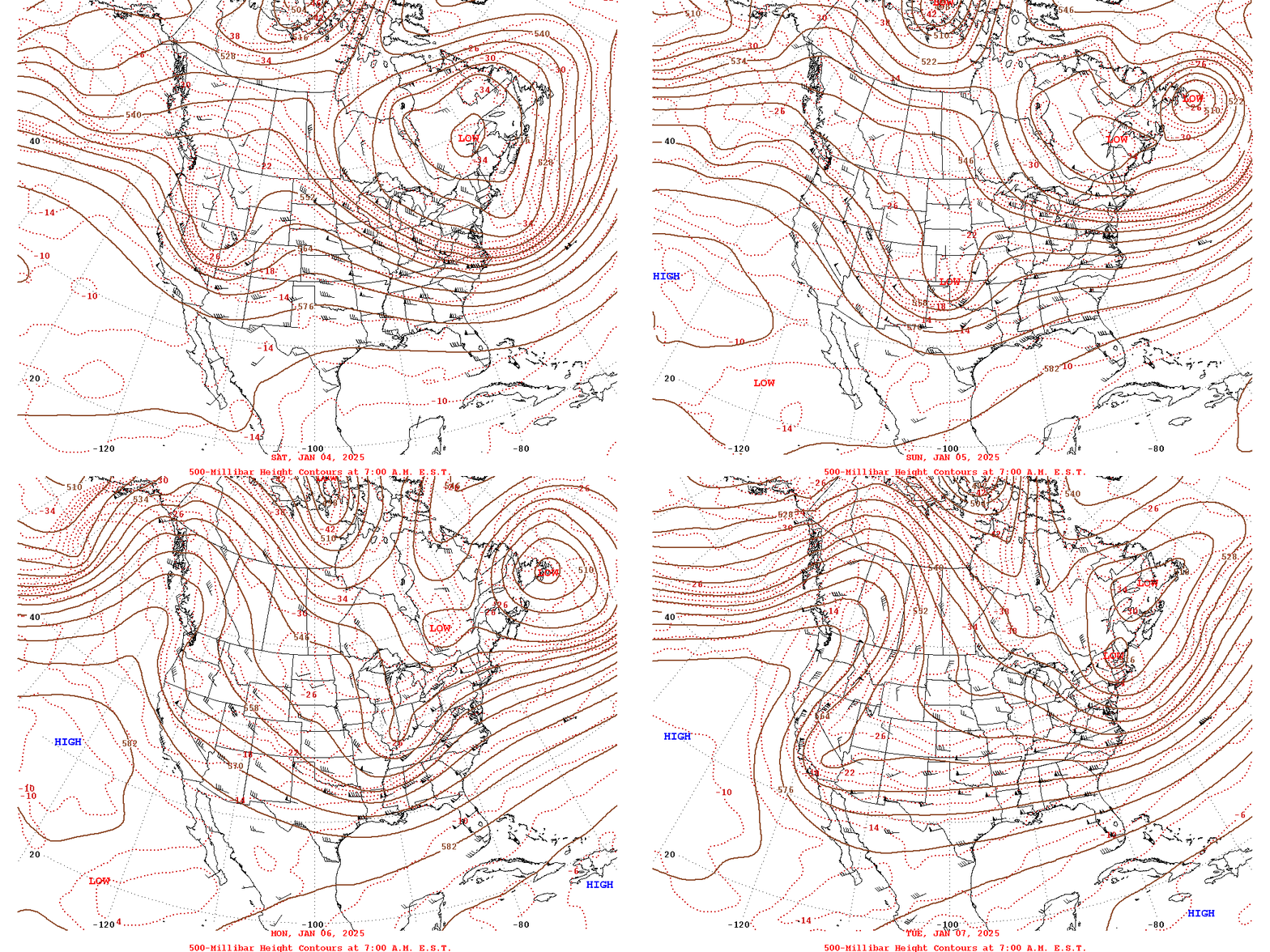 |
| WPC Surface Analysis Loop from 1/5 at 12z/7 AM to 1/7 at 00z (7 PM on 1/6) in 3 hour increments | WPC 500mb Daily 12z/7 AM Analysis from 1/4 to 1/7 |
Near-storm environment summary.
 |
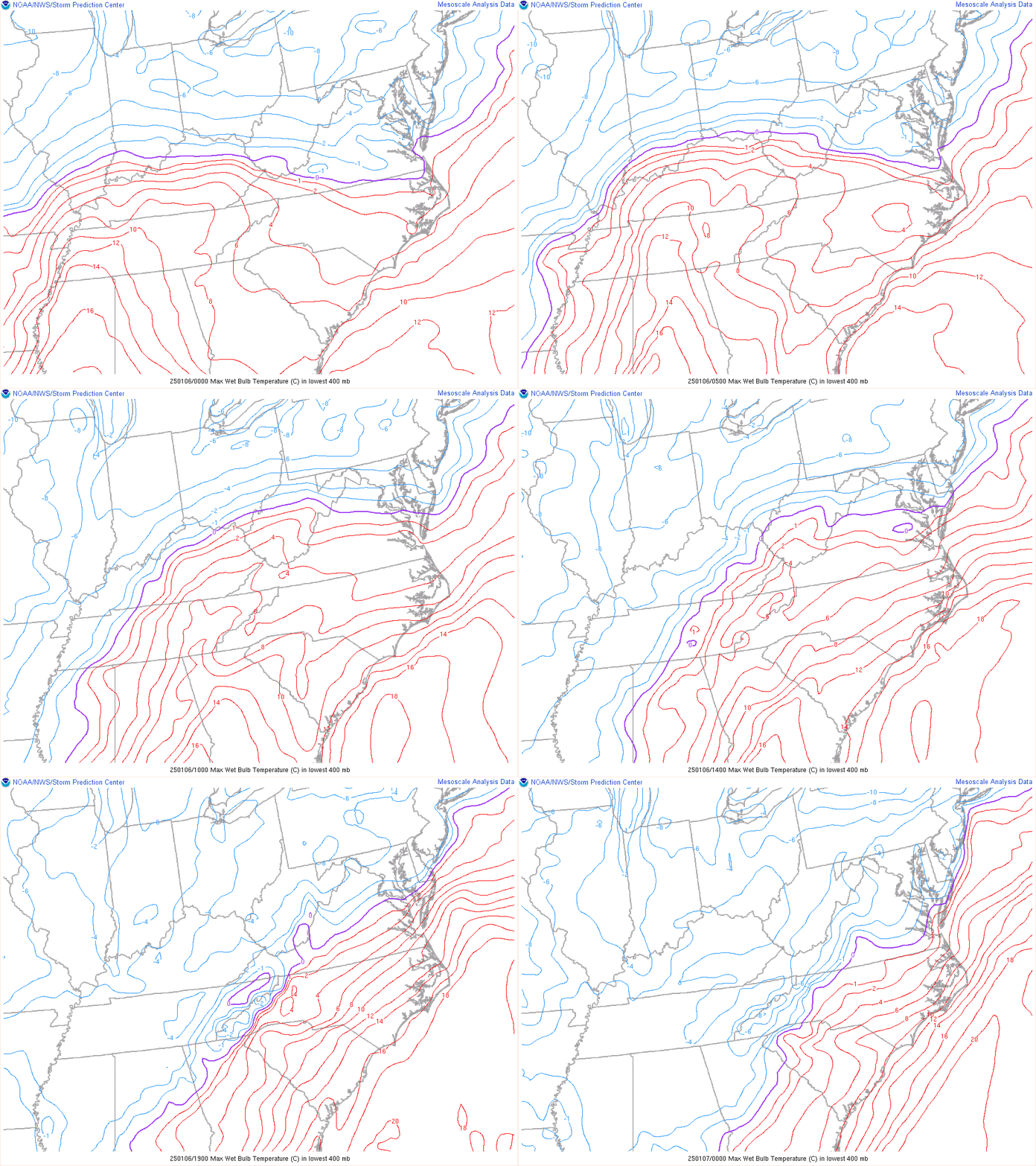 |
| Loop of 700mb Frontogenesis from 00z to 18z on 1/6 (7 PM on 1/5 to 1 PM on 1/6) in 1 hour increments | Loop of Max Wet Bulb Aloft from 00z on 1/6 to 00z on 1/7 (7 PM on 1/5 to 7 PM on 1/6) in 1 hour increments |
Environmental sounding and regional observation data.
 |
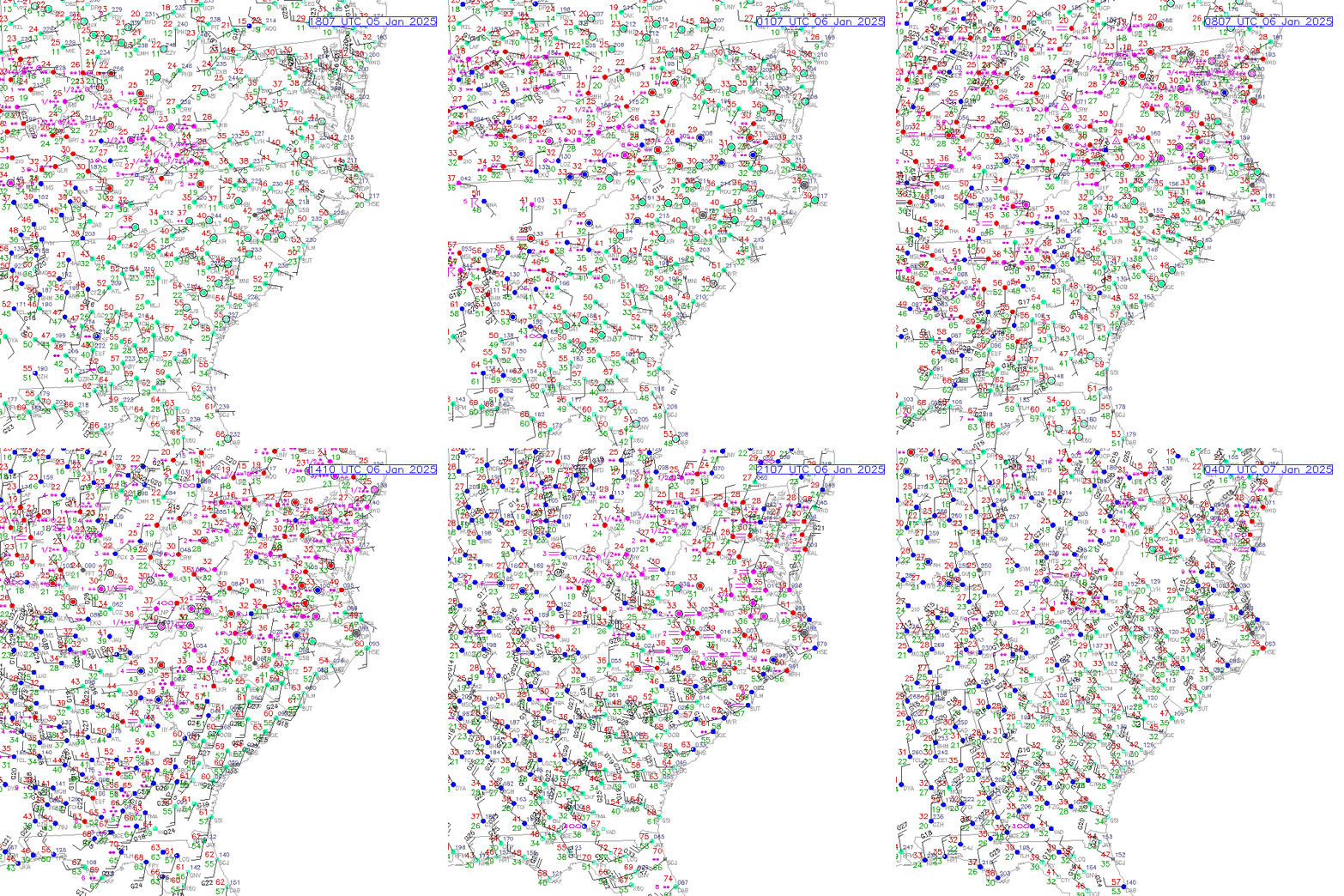 |
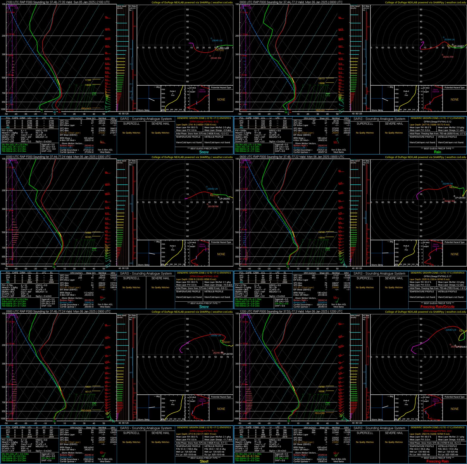
| Loop of KRIC RAP Analysis Soundings from 21z/4 PM on 1/5 to 12z/7 AM on 1/6 in 3 hour increments | Loop of Regional Surface Observations from 1 PM on 1/5 to 11 PM on 1/6 in 1 hour increments |
 |
Media use of NWS Web News Stories is encouraged! Please acknowledge the NWS as the source of any news information accessed from this site. |
 |