Overview
From 1/21 to 1/22, strong low pressure tracked from the central Gulf of America northeast to about 150 miles off the Carolina coast. At the same time, 1040+mb Arctic high pressure slowly built from the southern Plains to the Lower Mississippi/Tennessee Valleys. Aloft, a sharpening but positively tiled shortwave trough crossed the area during the evening of the 21st through the early morning of the 22nd. Mid level clouds (and forcing for ascent) had already overspread the entire area by the afternoon of the 21st in advance of that shortwave. The very cold, dry low level Arctic airmass was in place over the entire area, with temperatures in the lower-mid 20s (with dew points around 0F!) during the afternoon before any snow had started to fall.
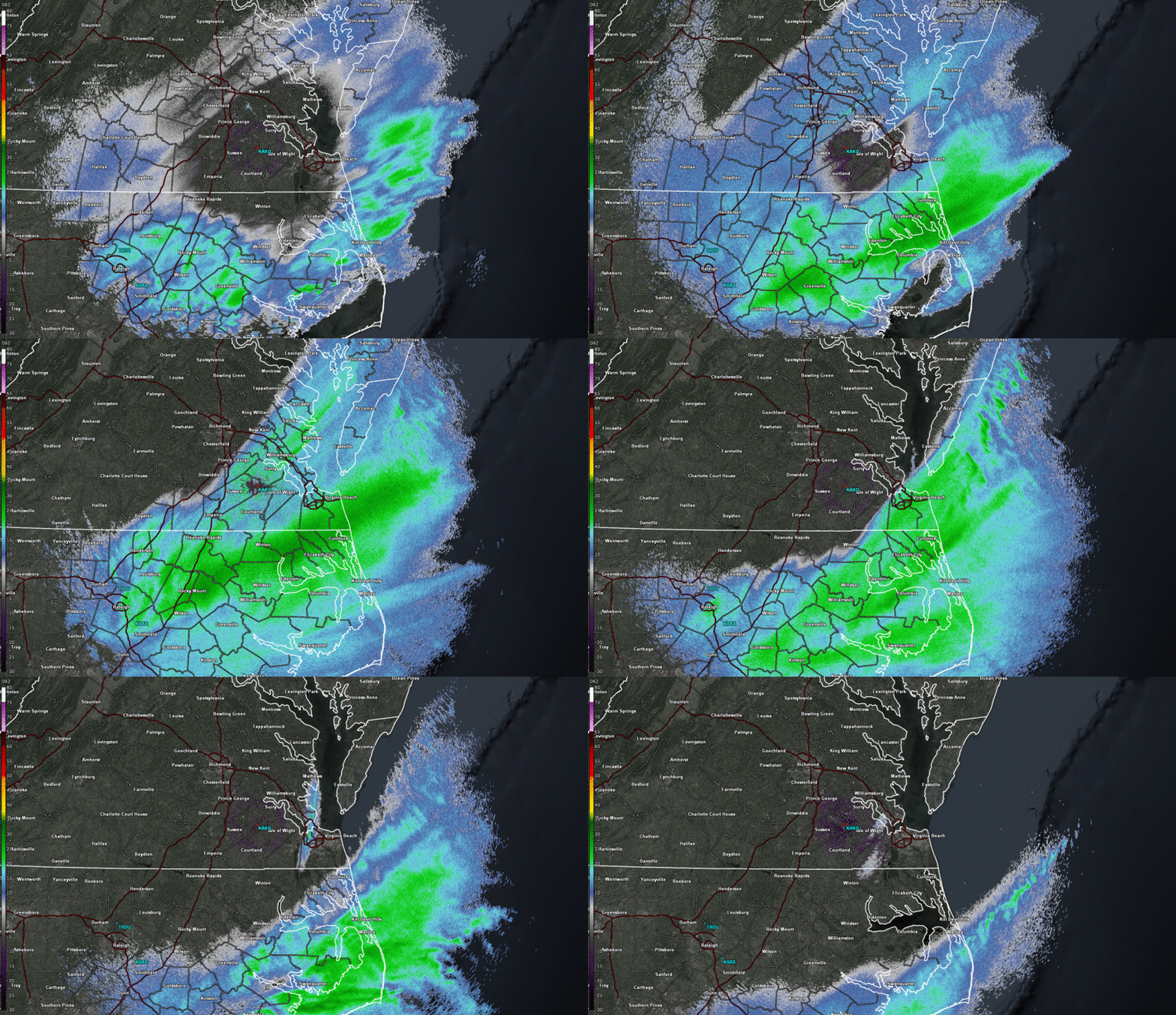
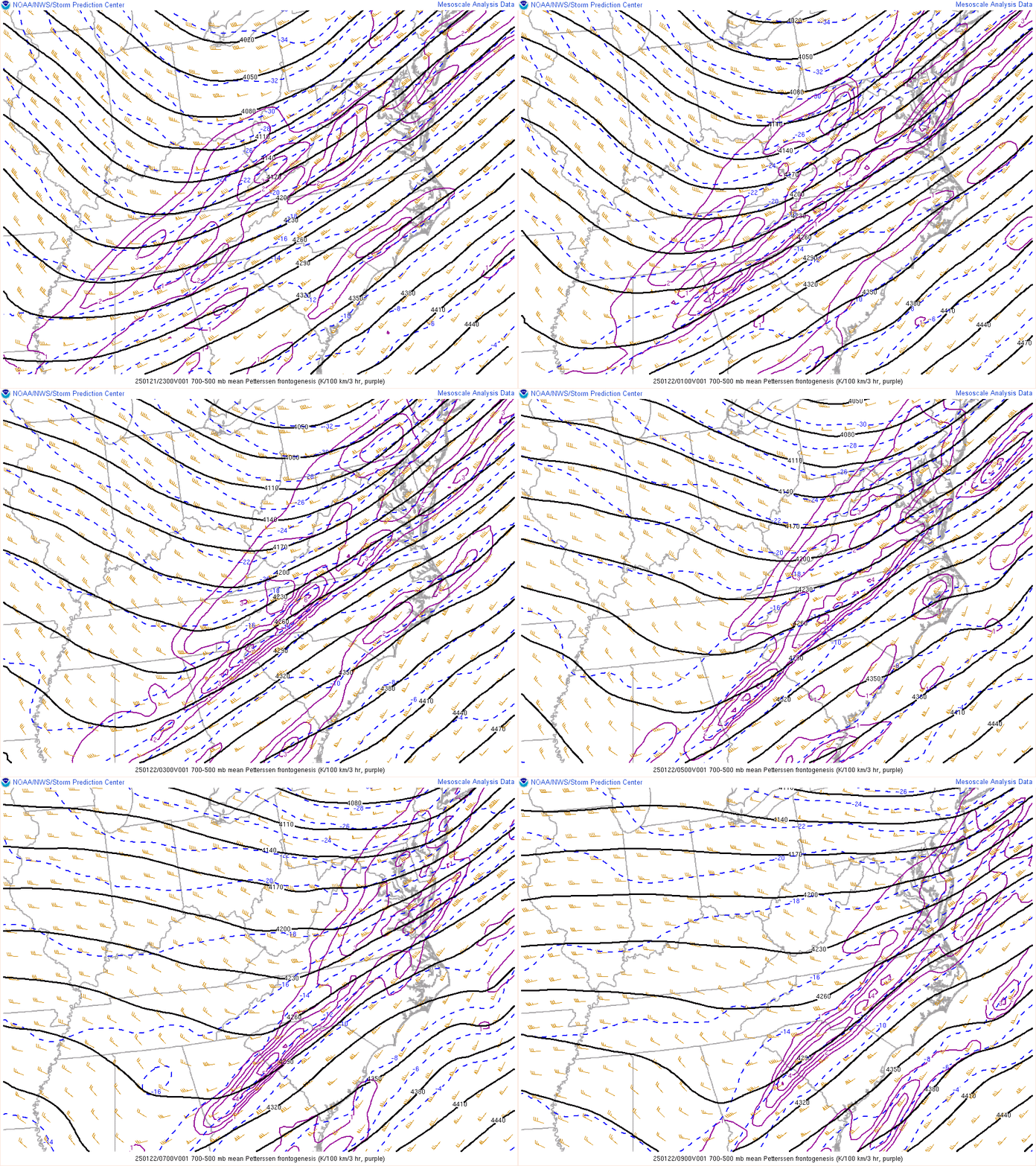
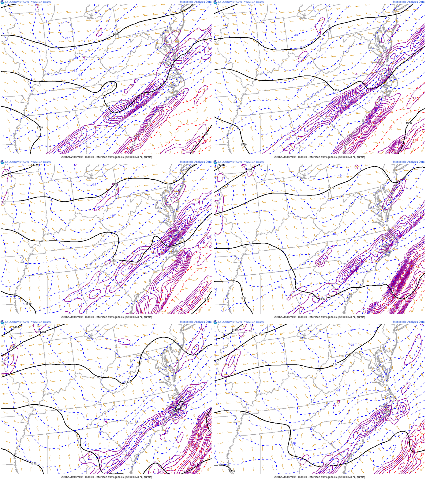
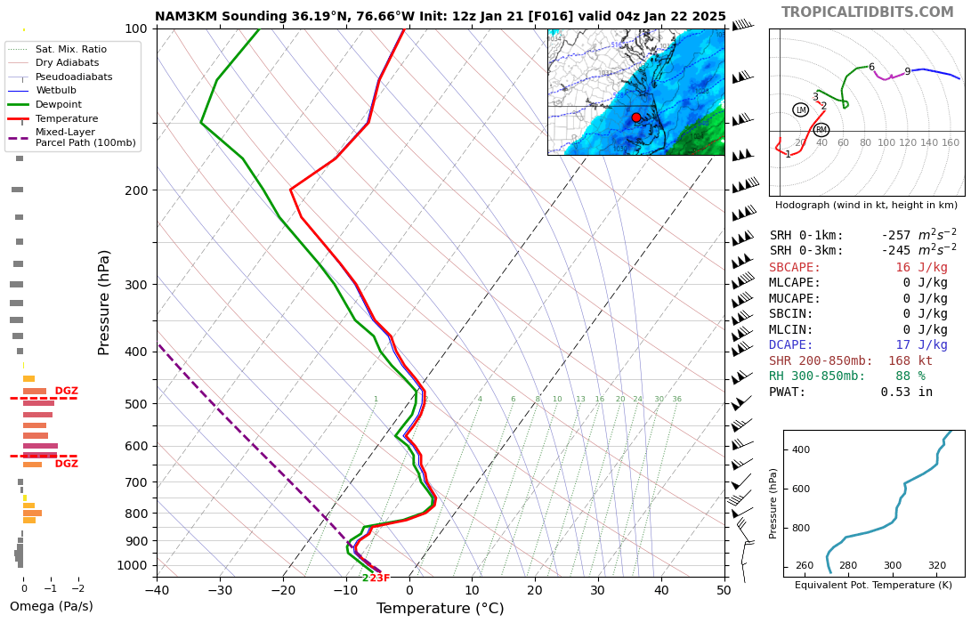
Even though the surface low tracked well to the southeast of the area, mid to upper level forcing for ascent was strong given decent WAA aloft. More importantly, the sloping mid/upper level frontogenesis zone was over the area, with the strongest FGen in the dendritic growth zone (700-550mb) residing over SE VA during the evening-early overnight. Despite the very cold/dry antecedent airmass, light snow began falling as far west as the Richmond Metro by 7 PM. The low-levels then quickly saturated area-wide by 8-9 PM. Most of the snow was light in intensity, but a band of moderate to heavy snow (likely with 1-2”/hour rates) set up across extreme SE VA and NE NC on the warm side of the mid-level FGen zone (see Environment section for more details). In addition, given the very cold temperatures (and forcing for ascent concentrated in the DGZ), snow liquid ratios were 15-20:1 even across NE NC! Also, as the low-levels were so cold (925mb temps were -13 to -16C) and the flow was initially out of the north…some additional enhancement of the snow was observed across Norfolk due to moisture flow off the bay. This is rare in our area, but is exactly like lake enhancement which occurs often in the snowbelt regions of the Great Lakes. The steady snow ended between midnight and 4 AM as the shortwave quickly pushed to our SE, but totals in NE NC were an impressive 3-7” (locally 8”). Southern portions of Hampton Roads saw around 3”, with localized totals around 4” in that area of Norfolk that saw “bay enhanced” snow.
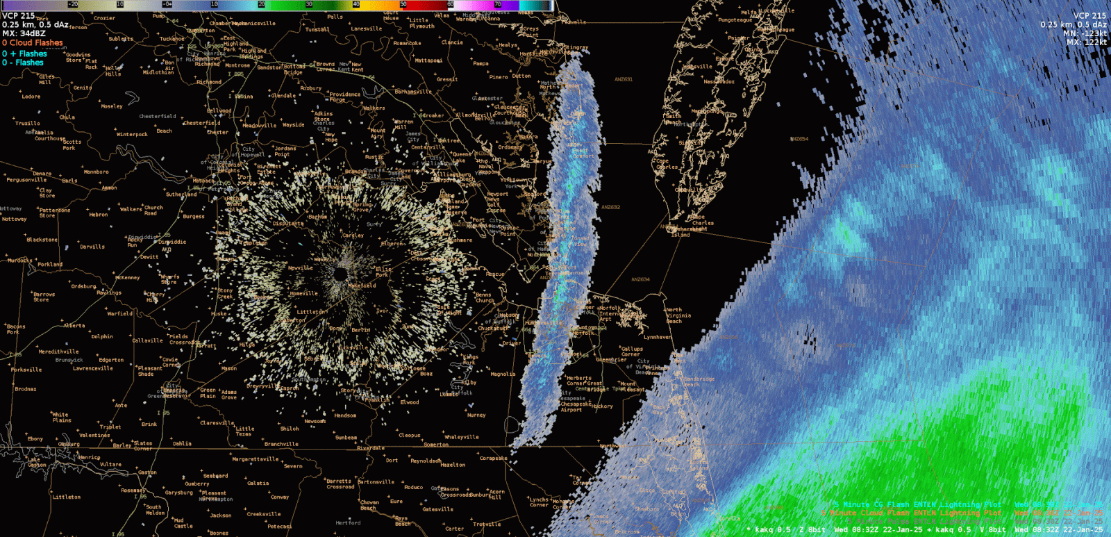
After the steady, synoptic snow ended, a “bay effect” snow band developed as there was very little shear from the sfc to 900mb with the top of that layer in the DGZ. In addition, the difference between the water temperature (38F/3C) and the 900mb temperature (~-15C) was much more than enough for a few hundred J/kg of “bay induced” instability. This combination of factors set the stage for a true bay effect snow event that likely produced localized snow totals of 0.5” on top of what already fell. Radar imagery showed 25dBz echoes in the middle of that (very narrow) bay effect snowband for a short period of time, which likely corresponded to 1”/hour snowfall rates. The bay effect band drifted west and weakened by 5-6 AM as the fetch over the bay was disrupted with the low-level flow shifting from 360° to 010-020°. We hypothesized that if the flow had remained due north, the band could have produced an additional 2-3” of snow over a 5-10 mile wide area.
Snowfall Map
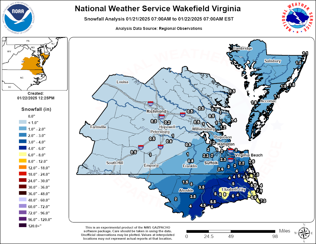 |
| Storm Total Snowfall Map |
Radar
Selected Radar Loops
 |
 |
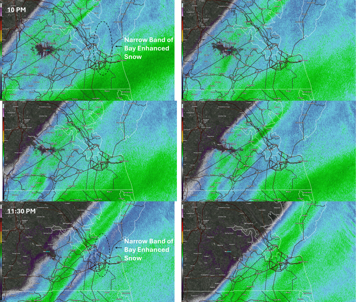 |
| Radar Loop from 6 PM on 1/21 to 7 AM on 1/22 in 30 minute increments | Close up view of the bay effect snow band when it was near its peak intensity | Zoomed in radar loop from 10 PM to midnight showing the narrow area of bay enhanced snow near Norfolk. Note that this area got 4" of snow with 2.5-3" immediately to the west and east |
Storm Reports
Public Information Statement
National Weather Service Wakefield VA
1125 AM EST Wed Jan 22 2025

...SNOWFALL REPORTS...

Location                     Amount    Time/Date       Provider

...Maryland...

...Worcester County...
Berlin 3.9 SE                1.2 in    0700 AM 01/22   COCORAHS
Bishopville 3.1 E            1.1 in    0500 AM 01/22   COCORAHS

...North Carolina...

...Bertie County...
Merry Hill                   4.5 in    0908 AM 01/22   Fire Dept/Rescue
Windsor                      4.0 in    0700 AM 01/22   CO-OP Observer
Powellsville                 3.5 in    0906 AM 01/22   Emergency Mngr
Lewiston Woodville           2.0 in    0700 AM 01/22   CO-OP Observer

...Camden County...
Camden                       6.5 in    0837 AM 01/22   Public
1 SSW Camden                 5.0 in    0456 AM 01/22   Public
Burnt Mills                  5.0 in    0830 AM 01/22   Public
1 E South Mills              4.0 in    0600 AM 01/22   Public

...Chowan County...
Edenton                      6.0 in    0832 AM 01/22   Public
1 NNW Edenton                5.5 in    0745 AM 01/22   Public

...Currituck County...
1 E Grandy                   7.5 in    0600 AM 01/22   Cocorahs
1 SSW Knotts Island          7.5 in    0800 AM 01/22   Public
Point Harbor                 7.3 in    0840 AM 01/22   Public
1 NNW Mamie                  6.5 in    0540 AM 01/22   Public
1 NW Currituck               6.3 in    0720 AM 01/22   Amateur Radio
1 E Point Harbor             6.0 in    0830 AM 01/22   Public
Aydlett                      5.5 in    0526 AM 01/22   Public
4 NW Moyock                  5.0 in    0800 AM 01/22   Public
3 SSE Corolla                4.0 in    0550 AM 01/22   Fire Dept/Rescue
5 NW Moyock                  4.0 in    0900 AM 01/22   Public

...Hertford County...
Harrellsville                3.5 in    0800 AM 01/22   Public
Ahoskie                      3.5 in    0945 AM 01/22   Public
Winton                       3.0 in    0945 AM 01/22   Park/Forest Srvc
Winton                       1.5 in    0900 AM 01/22   Emergency Mngr

...Pasquotank County...
1 NW Okisko                  8.0 in    0940 AM 01/22   County Official
Nixonton                     6.0 in    0700 AM 01/22   Cocorahs
1 NW Elizabeth City          5.8 in    0730 AM 01/22   Public
2 WNW Weeksville             4.0 in    1248 AM 01/22   Other Federal

...Perquimans County...
1 NNW Chapanoke              6.2 in    0800 AM 01/22   Public
Hertford                     6.0 in    0558 AM 01/22   Public
1 NNW Hertford               5.0 in    0620 AM 01/22   Public

...Virginia...

...Accomack County...
Accomac                      2.0 in    0810 AM 01/22   Public
Harborton                    1.8 in    0503 AM 01/22   Emergency Mngr
2 NE Atlantic                1.5 in    0100 AM 01/22   CO-OP Observer
Chincoteague 0.6 SE          1.5 in    0700 AM 01/22   COCORAHS
Metompkin 0.9 SE             1.1 in    0700 AM 01/22   COCORAHS

...Brunswick County...
Alberta                      0.5 in    0700 AM 01/22   Public

...Chesterfield County...
1 NW Chester                 0.3 in    1000 PM 01/21   NWS Employee
2 WSW Meadowville            0.2 in    0845 PM 01/21   NWS Employee

...City of Chesapeake County...
2 SSE Hickory                4.0 in    0839 AM 01/22   Public
2 SSE Hickory                3.5 in    0540 AM 01/22   Broadcast Media
1 ESE Herberts Corner        3.5 in    0630 AM 01/22   Public
2 ENE Herberts Corner        3.5 in    0845 AM 01/22   Amateur Radio
2 WSW Great Bridge           3.0 in    0200 AM 01/22   Broadcast Media
2 SW Great Bridge            3.0 in    0635 AM 01/22   Public
1 WSW Herberts Corner        3.0 in    0700 AM 01/22   Public
1 SSW Herberts Corner        3.0 in    0841 AM 01/22   Public
1 SW Greenbrier              3.0 in    0900 AM 01/22   Public
Great Bridge                 3.0 in    0913 AM 01/22   Trained Spotter
3 N Fentress                 3.0 in    0927 AM 01/22   Trained Spotter
8 SW Chesapeake Airport      2.6 in    1000 AM 01/22   CO-OP Observer
1 SSW Great Bridge           2.5 in    0631 AM 01/22   Public

...City of Franklin County...
1 ESE Franklin               1.0 in    0606 AM 01/22   Public

...City of Hampton County...
Fox Hill                     3.1 in    0808 AM 01/22   Public
1 W Buckroe Beach            2.5 in    0831 AM 01/22   Public
Hampton 3.4 W                2.0 in    0709 AM 01/22   COCORAHS
2 WNW Phoebus                1.8 in    0556 AM 01/22   Public
Langley View                 1.6 in    0800 AM 01/22   Public
2 N Northampton              1.5 in    0527 AM 01/22   Public
1 W Langley Afb              1.5 in    0630 AM 01/22   Public

...City of Newport News County...
1 SW Beaconsdale             1.6 in    0700 AM 01/22   Public
Beaconsdale                  1.5 in    0302 AM 01/22   Public
1 WSW Beaconsdale            1.5 in    0700 AM 01/22   COCORAHS
Newport News 1.1 NNE         1.2 in    1235 AM 01/22   COCORAHS
Newport News 5.8 N           1.0 in    0700 AM 01/22   COCORAHS

...City of Norfolk County...
2 SSE Norview                4.1 in    0700 AM 01/22   Emergency Mngr
1 SSE Ocean View             4.0 in    0300 AM 01/22   Trained Spotter
1 SE Norview                 3.8 in    0520 AM 01/22   CO-OP Observer
2 SE Norview                 3.5 in    0100 AM 01/22   CO-OP Observer
2 NW Norfolk International A 3.0 in    0700 AM 01/22   Trained Spotter
1 W Norview                  2.9 in    0829 AM 01/22   Public
Downtown Norfolk             2.1 in    0223 AM 01/22   Public
1 WSW Norfolk International  2.0 in    0530 AM 01/22   Public
1 NNW Ghent                  1.8 in    0500 AM 01/22   Trained Spotter

...City of Poquoson County...
1 SW Poquoson                1.5 in    0700 AM 01/22   Cocorahs

...City of Portsmouth County...
1 E Western Branch           2.8 in    0801 AM 01/22   Public
1 SW Downtown Portsmout      2.5 in    0523 AM 01/22   Public
1 NW Cradock                 2.3 in    0850 AM 01/22   Trained Spotter
1 NW Cradock                 2.3 in    0900 AM 01/22   Trained Spotter
Downtown Portsmout           2.0 in    0836 AM 01/22   Public

...City of Suffolk County...
Portsmouth 5.1 WNW           2.0 in    0700 AM 01/22   COCORAHS
Suffolk 13.9 NNE             1.5 in    0700 AM 01/22   COCORAHS
1 N Deanes                   1.5 in    0830 AM 01/22   Trained Spotter
Suffolk 1.4 NNW              1.0 in    0700 AM 01/22   COCORAHS

...City of Virginia Beach County...
2 N Munden                   4.0 in    0911 AM 01/22   Emergency Mngr
2 N Greenbrier               3.5 in    0800 AM 01/22   Amateur Radio
2 SSW Gallups Corner         3.1 in    1021 AM 01/22
2 N Princess Anne            3.0 in    0800 AM 01/22   Public
2 SSW Kempsville             2.8 in    0834 AM 01/22   Public
2 NNW Sigma                  2.6 in    0135 AM 01/22   Public
2 NNW Princess Anne          2.5 in    0800 AM 01/22   Amateur Radio
1 NW Oceana                  2.5 in    0912 AM 01/22   Emergency Mngr
1 NE Princess Anne           2.3 in    0815 AM 01/22   Trained Spotter

...City of Williamsburg County...
Williamsburg 1.4 ENE         1.1 in    0700 AM 01/22   COCORAHS

...Dinwiddie County...
Dinwiddie                    0.5 in    0820 AM 01/22   Public

...Gloucester County...
Gloucester Point 2.4 E       1.2 in    0700 AM 01/22   COCORAHS
1 S Ware Neck                1.0 in    0647 AM 01/22   Trained Spotter
Gloucester 3.9 ESE           1.0 in    0700 AM 01/22   COCORAHS
Gloucester Courthouse 7.1 NN 1.0 in    0800 AM 01/22   COCORAHS
1 NE Gloucester Courthouse   1.0 in    0800 AM 01/22   Public
James Store 1.5 WNW          0.9 in    0700 AM 01/22   COCORAHS
Ark                          0.5 in    0630 AM 01/22   Public

...Greensville County...
Purdy                        1.0 in    1045 PM 01/21   Trained Spotter

...Isle of Wight County...
1 SSW Longview               2.3 in    0838 AM 01/22   Public
1 E Franklin                 2.2 in    1207 AM 01/22   Trained Spotter
1 E Longview                 2.0 in    0551 AM 01/22   Public
2 NNW Benns Church           2.0 in    0630 AM 01/22   NWS Employee
1 W Smithfield               1.0 in    0559 AM 01/22   Public
2 ESE Carrollton             1.0 in    0800 AM 01/22   Public
1 SSW Rushmere               1.0 in    0830 AM 01/22   Public

...James City County...
1 SSE Ewell                  1.0 in    1132 PM 01/21   Public
Williamsburg 3.4 SW          1.0 in    0700 AM 01/22   COCORAHS
Lightfoot                    0.5 in    1059 PM 01/21   Public
Lightfoot                    0.5 in    0800 AM 01/22   Public

...King William County...
1 N West Point               0.5 in    1026 AM 01/22   CO-OP Observer

...Mathews County...
Port Haywood 2.1 ESE         1.4 in    0700 AM 01/22   COCORAHS

...Mecklenburg County...
3 NE Baskerville             0.5 in    0800 AM 01/22   Public

...Middlesex County...
Hartfield 1.5 WNW            0.7 in    0800 AM 01/22   COCORAHS

...New Kent County...
New Kent                     0.5 in    0808 AM 01/22   Public

...Northumberland County...
1 NW Fair Port               0.5 in    1020 PM 01/21   Trained Spotter

...Prince George County...
Disputanta                   1.0 in    0757 AM 01/22   Public
3 SSE Templeton              0.6 in    1000 PM 01/21   NWS Employee
1 SSE Fort Gregg-Adams       0.5 in    0930 PM 01/21   Public
1 W Prince George            0.5 in    1015 PM 01/21   NWS Employee

...Southampton County...
Sedley 3.7 N                 1.0 in    0700 AM 01/22   COCORAHS
2 NNW Hunterdale             0.8 in    0516 AM 01/22

...Sussex County...
2 NW Wakefield               0.9 in    1200 AM 01/22   Official NWS Obs

...York County...
Tabb                         1.6 in    0640 AM 01/22   Public
Lightfoot                    0.8 in    0637 AM 01/22   Public
&&
Environment
Synoptic summary.
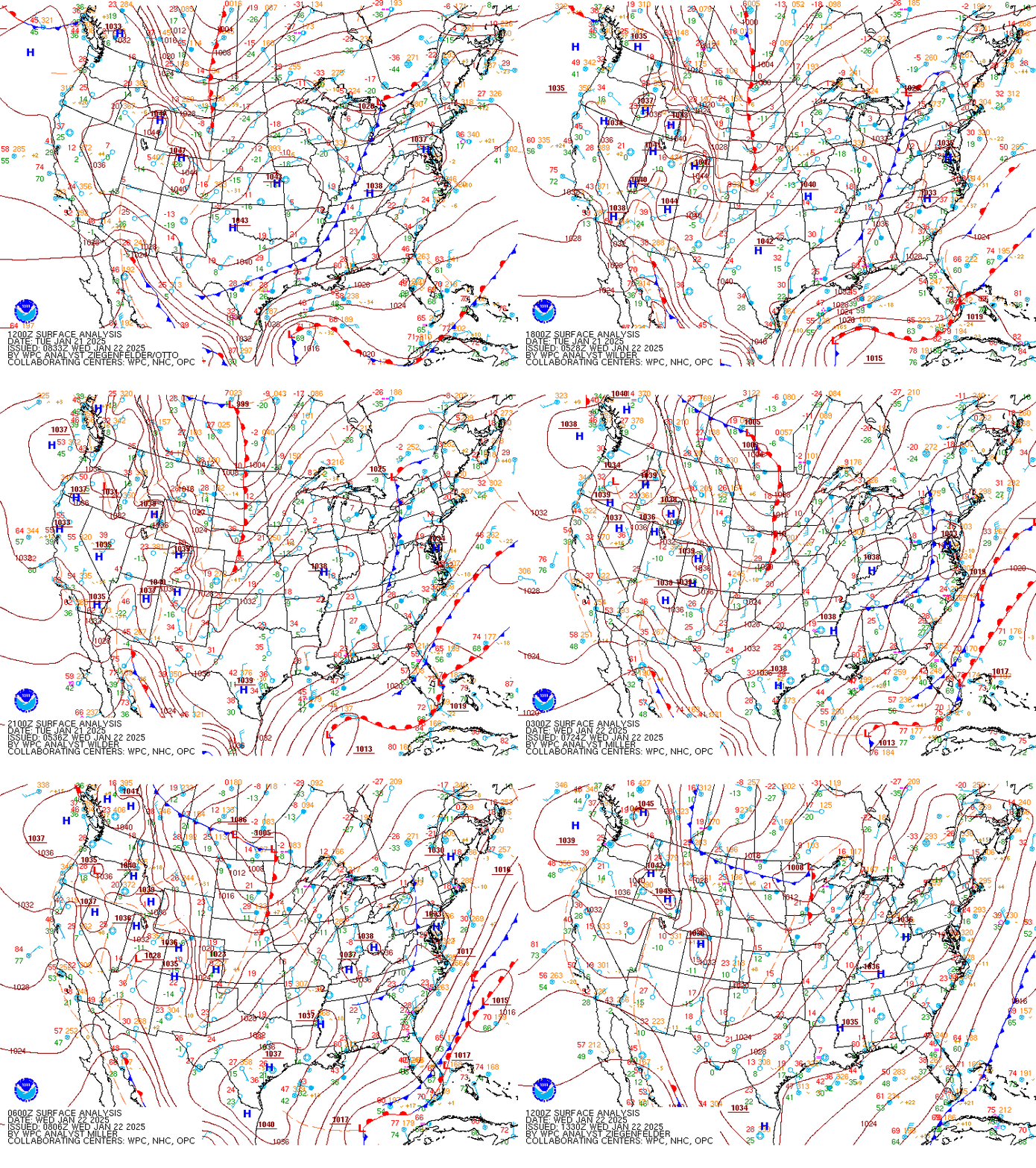 |
| Loop of WPC Surface Analysis from 7 AM on 1/21 to 7 AM on 1/22 in 3 hour increments |
Near-storm environment summary.
 |
 |
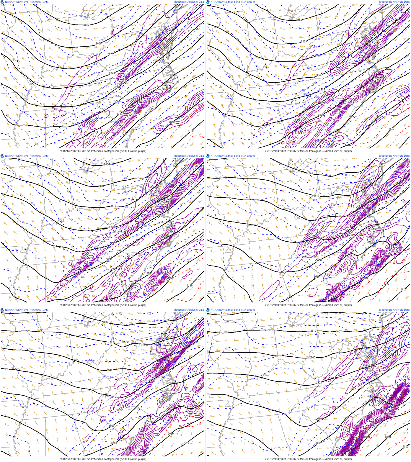 |
| Loop of 700-500mb Frontogenesis from 6 PM on 1/21 to 7 AM on 1/22 | Loop of 700mb Frontogenesis from 5 PM on 1/21 to 7 AM on 1/22 | Loop of 850mb Frontogenesis from 5 PM on 1/21 to 7 AM on 1/22 |
 |
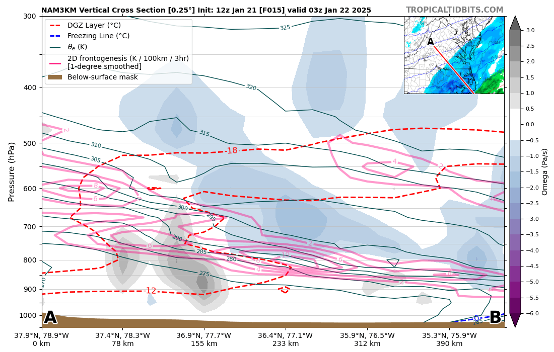 |
| 16 hour NAMNest forecast sounding for NE NC valid at 11 PM on 1/21. Note that this was in the middle of the strong FGen snow band and there was even some upright instability in the dendritic growth zone! This ended up verifying well. | 15 hour NAMNest forecast Cross section of temperature, frontogenesis, and vertical motion (omega) valid at 10 PM on 1/21. This ended up verifying well. |
 |
Media use of NWS Web News Stories is encouraged! Please acknowledge the NWS as the source of any news information accessed from this site. |
 |