Overview
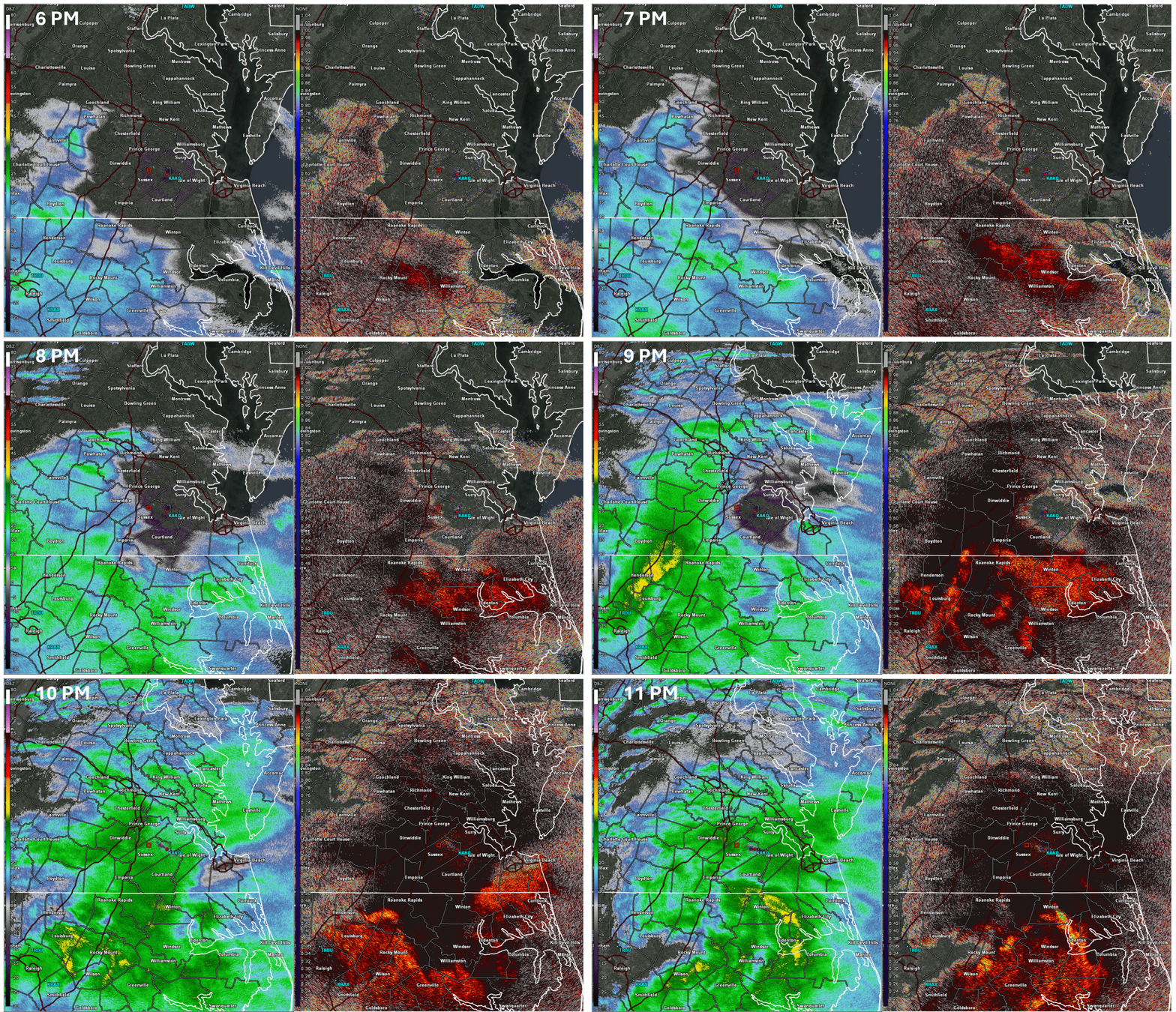
After a nearly snowless period of almost 3 years, January 10-11, 2025 marked the second winter storm to impact the Wakefield CWA in less than a week. Cold air remained in place and even though the low-level flow was out of the south to southwest through most of the event, snow was the predominant precipitation type across the northern 2/3 of the area. Precipitation moved in during the evening of 1/10 and it was initially all snow (except across coastal NE NC) as temperatures dropped to the 28-31F range area-wide and the column was below freezing. However, temperatures from 925-700mb were only a couple degrees below freezing and with deep layered SW flow, this would create p-type issues later in the event. Initially (through about 12-1 AM), there was moderate to strong lift in the dendritic growth zone (which was around 500mb thanks to relatively high 850-700mb thicknesses). A widespread 1-3 inches of snow fell across most areas near and south of the I-64 corridor (including Hampton Roads) from 8 PM through 1 AM.
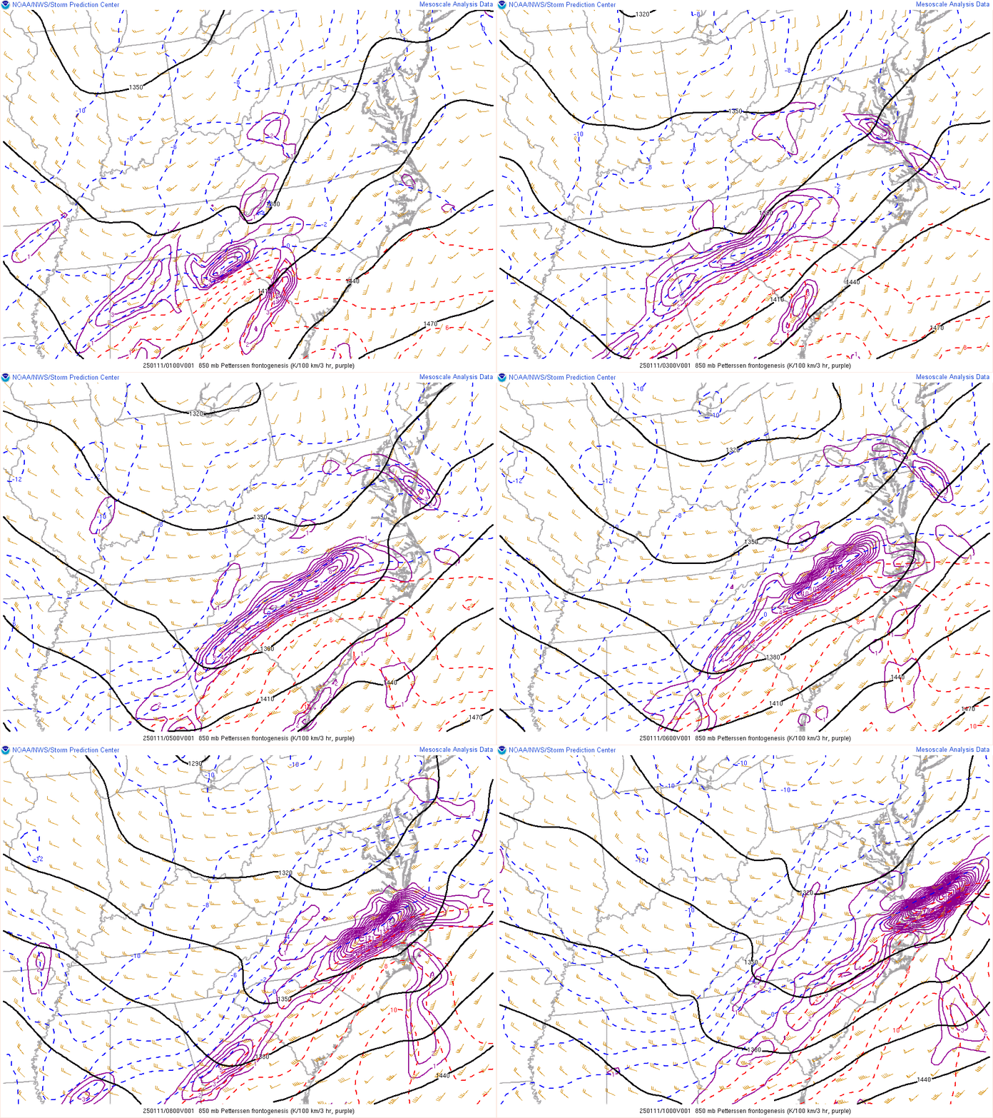
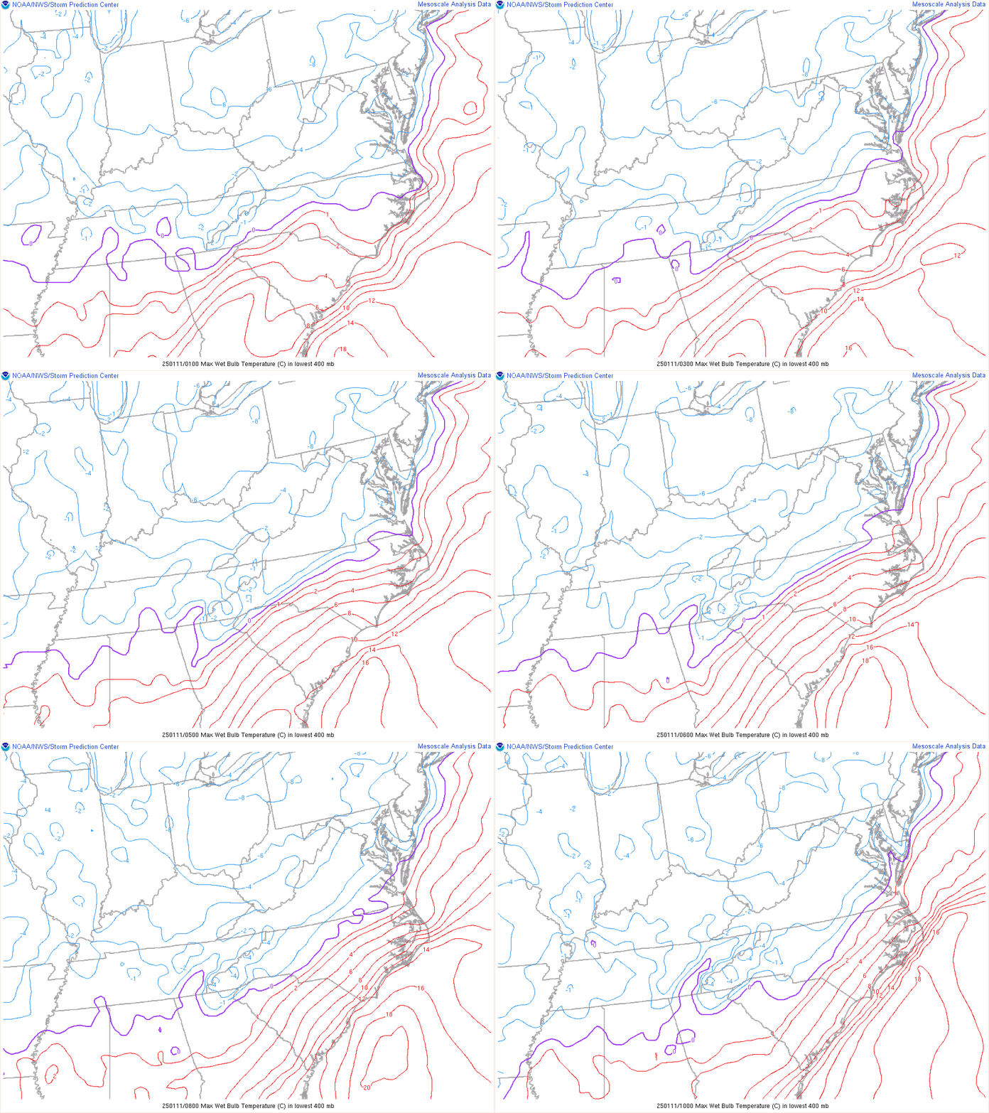
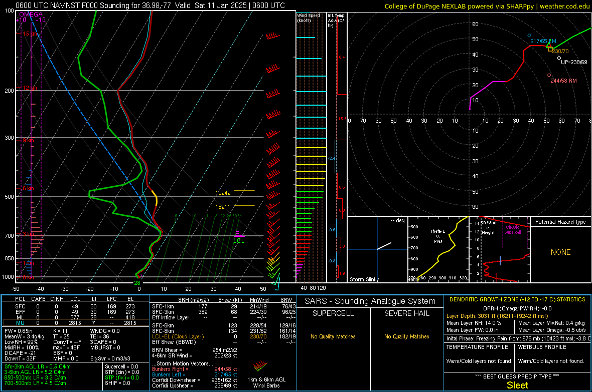
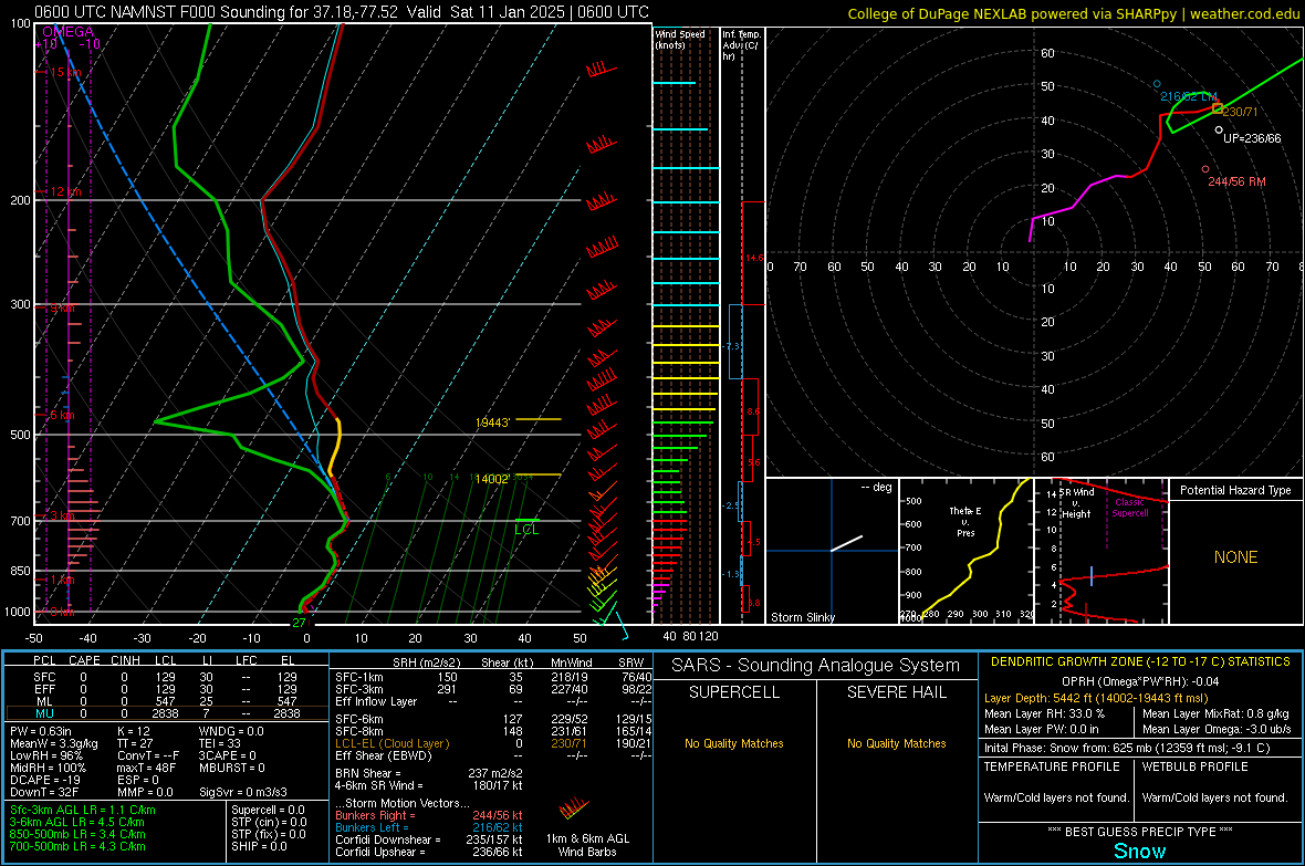
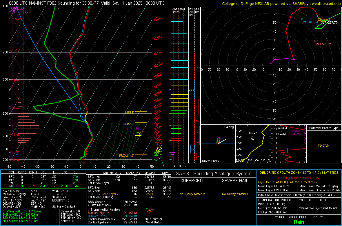
Then, the forcing for ascent in the DGZ moved offshore and some drier air moved in around 500-600mb. However, a band of strong 850-700mb frontogenesis overspread the area after 1 AM as sfc low pressure begun to deepen just off the Carolina coast. In addition, mesoanalysis showed a strong (50-60+ knot) 850mb jet across eastern NC during the early morning hours of 1/11 (which makes sense given the above mentioned FGen fields). This resulted in a second round of moderate to occasionally heavy precipitation. However, with the drying above 600mb and WAA thanks to the strong low-level jet, precipitation was a mix of snow, sleet, freezing rain, and rain south of an Emporia-Wakefield-Williamsburg line after 130-230 AM. Note that precip had already changed to liquid across far SE VA and all of NE NC before this time. Interestingly, radar (thanks to the Correlation Coefficient product) showed that snow began to change to a wintry mix across southern Dinwiddie County by 130 AM and that eventually spread east and southeast over the next hour. Usually, precipitation changes from snow to rain from S/SE to N/NW at a steady pace during "snow to rain" type events in our area. Also, the snow/mix/rain line was a bit farther north than some of the guidance/forecasts had anticipated. This obviously cut down on snow totals in SE VA. After examining forecast soundings and mesoanalysis, this could have been due to one (or both) of the following reasons:
1) Cloud ice introduction was lost (note the drying observed in the soundings above the -10C layer.
2) The strong low-level jet was able to advect the thin, +1-2C warm nose farther north than the guidance had anticipated.
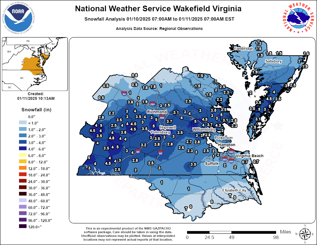
Precipitation quickly moved offshore after 5-6 AM. The highest snow totals (3.5-5.5”) were observed from the south-central VA Piedmont to the southern Richmond Metro to Williamsburg to the VA Eastern Shore (where the heavier precip stayed in the form of snow). A widespread 1-3” was observed farther south and north of this area. Little to no snow fell in extreme SE VA and much of NE NC.
Snowfall Maps
 |
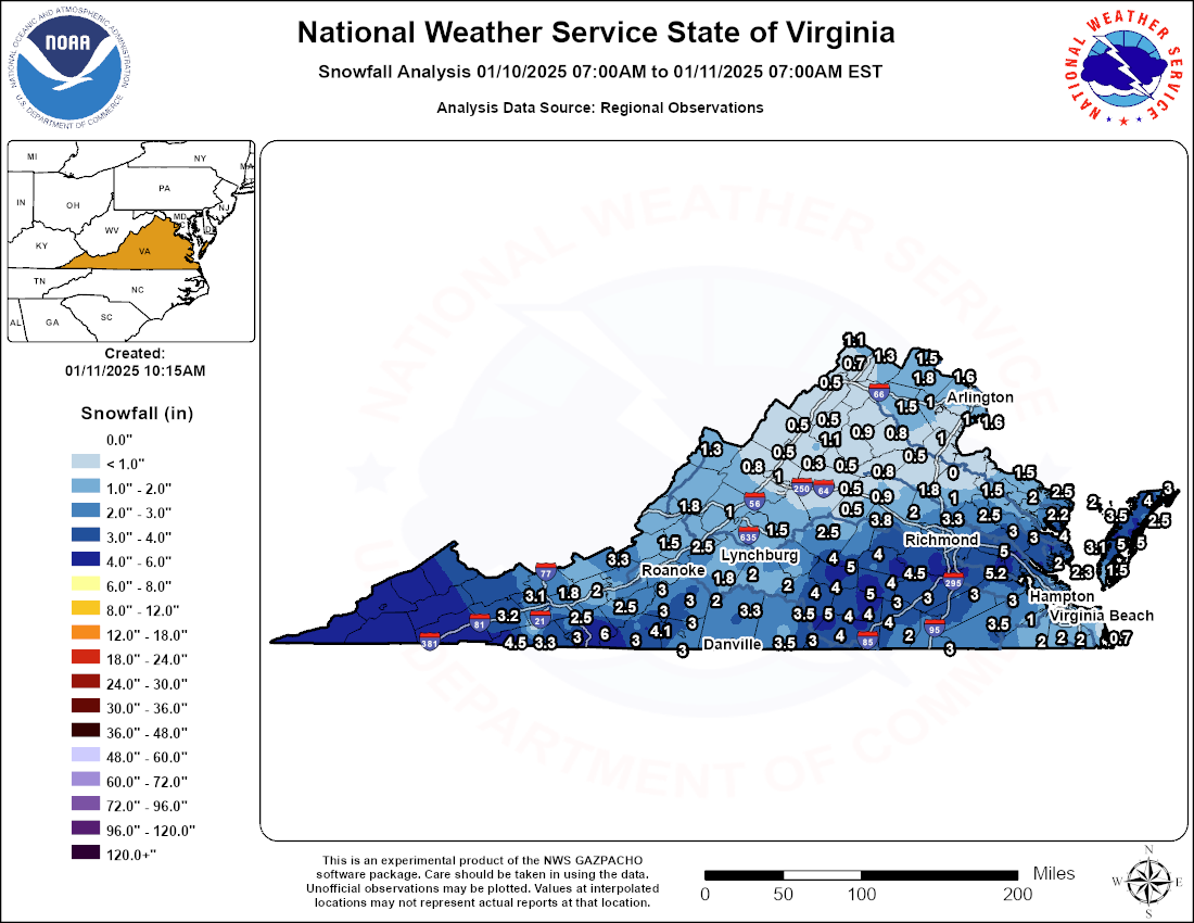 |
| AKQ CWA Snowfall Map | VA State Snowfall Map |
Radar
Selected Radar Loops
 |
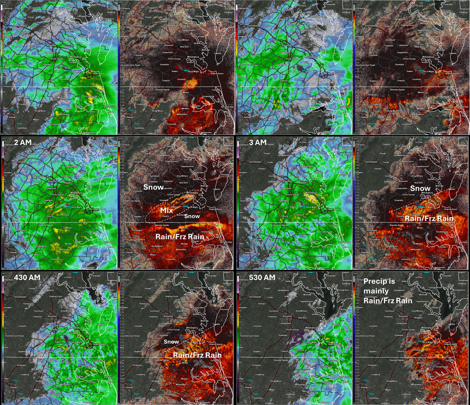 |
| Loop of KAKQ Radar 0.5° Reflectivity (left) and Correlation Coefficient (right) from 6 PM to 11 PM in 30 min increments | Loop of KAKQ Radar 0.5° Reflectivity (left) and Correlation Coefficient (right) from 1130 PM to 530 AM in 30 min increments. Note the expansion of lower CC values from Dinwiddie County eastward from 130 to 3 AM. This represents the snow changing over to freezing rain and sleet. Just to the north of the lower CC values, precipitation stayed as snow through the entire event, leading to higher totals up to 5-5.5". |
Storm Reports
Public Information Statement
National Weather Service Wakefield VA
1121 PM EST Sat Jan 11 2025

...SNOWFALL REPORTS...

Location                     Amount    Time/Date       Provider

...Maryland...

...Dorchester County...
2 SE East New Market         1.5 in    0654 AM 01/11   Public
2 ENE East New Market        1.3 in    0948 AM 01/11   County Official

...Somerset County...
2 SSW Princess Anne          3.0 in    0700 AM 01/11   Cocorahs
1 E Crisfield                1.9 in    0700 AM 01/11   Cocorahs
Deal Island 0.5 SSW          1.9 in    0700 AM 01/11   COCORAHS

...Wicomico County...
2 W Parsonsburg              2.3 in    0700 AM 01/11   CO-OP Observer
Delmar 0.3 ESE               1.5 in    0600 AM 01/11   COCORAHS
Hebron 3.6 W                 1.5 in    0800 AM 01/11   COCORAHS
2 ESE Mardela Springs        1.5 in    0801 AM 01/11   Cocorahs

...Worcester County...
Berlin                       2.0 in    0724 AM 01/11   Trained Spotter
Berlin 3.9 SE                1.9 in    0700 AM 01/11   COCORAHS
Bishopville 3.1 E            1.6 in    0500 AM 01/11   COCORAHS

...North Carolina...

...Bertie County...
1 NW Windsor                  T in     1200 AM 01/11   Public

...Chowan County...
2 SSE Hancock                 T in     1200 AM 01/11   Public

...Hertford County...
Ahoskie                      1.0 in    0700 AM 01/11   Public

...Northampton County...
Jackson                      1.0 in    0700 AM 01/11   911 Call Center

...Pasquotank County...
2 SW Spences Corner          0.5 in    0734 AM 01/11   Public
Elizabeth City 7.7 SSW        T in     0815 AM 01/11   COCORAHS

...Virginia...

...Accomack County...
Painter 4.4 W                5.0 in    0600 AM 01/11   COCORAHS
Wachapreague                 5.0 in    0610 AM 01/11   Public
Accomac                      4.5 in    0735 AM 01/11   Public
Bloxom                       4.0 in    0656 AM 01/11   Public
1 N Exmore                   4.0 in    1000 AM 01/11   Public
Onley                        3.5 in    0623 AM 01/11   Public
Harborton                    3.5 in    0726 AM 01/11   Emergency Mngr
4 NW Exmore                  3.5 in    0900 AM 01/11   Public
Quinby                       3.0 in    0809 AM 01/11   Public
1 SSW Chincoteague           3.0 in    0950 AM 01/11   Public
Chincoteague 0.6 SE          2.5 in    0700 AM 01/11   COCORAHS
Metompkin 0.9 SE             2.5 in    0700 AM 01/11   COCORAHS
Tangier                      2.0 in    0800 AM 01/11   Public

...Amelia County...
2 ENE Truxillo               5.0 in    0900 AM 01/11   Public
3 E Scotts Fork              4.5 in    0751 AM 01/11   Public
Scotts Fork                  4.5 in    0759 AM 01/11   Public
2 S Deatonville              4.3 in    0700 AM 01/11   Cocorahs
1 NW Scotts Fork             4.0 in    0643 AM 01/11   Public
Amelia Courthouse            4.0 in    0752 AM 01/11   Public
Paineville                   3.5 in    0751 AM 01/11   Public
Giles Mill                   3.0 in    0600 AM 01/11   Public
1 NE Jetersville             2.5 in    0125 AM 01/11   Public

...Brunswick County...
Alberta                      4.0 in    0730 AM 01/11   Public
2 SE Danieltown              3.0 in    0830 AM 01/11   Public
Lawrenceville 1.2 SSW        2.8 in    0700 AM 01/11   COCORAHS
Valentines                   2.0 in    0240 AM 01/11   Public

...Caroline County...
2 S Dawn                     1.4 in    0700 AM 01/11   Cocorahs
Ruther Glen 1.7 ENE          1.0 in    0700 AM 01/11   COCORAHS

...Charles City County...
1 WSW Barnetts               4.0 in    0809 AM 01/11   Public

...Chesterfield County...
1 NNE Chesterfield           5.0 in    0723 AM 01/11   Trained Spotter
1 SE Pocahontas State Park   5.0 in    0855 AM 01/11   Public
1 SE Pocahontas State Park   5.0 in    1045 AM 01/11   NWS Employee
5 SSW Midlothian             4.0 in    0514 AM 01/11   NWS Employee
3 NW Hopewell                4.0 in    0746 AM 01/11   Trained Spotter
2 NW Beach                   4.0 in    0832 AM 01/11   Public
3 NNW Pocahontas State Park  3.8 in    0744 AM 01/11   Public
1 SE Meadowville             3.7 in    0500 AM 01/11   NWS Employee
Chester                      3.5 in    0545 AM 01/11   Public
Moseley 1.7 NNE              3.5 in    0700 AM 01/11   COCORAHS
Chesterfield 8.5 WSW         3.5 in    0700 AM 01/11   COCORAHS
3 NNW Hopewell               3.5 in    0732 AM 01/11   Public
Richmond 7.5 SW              3.0 in    0500 AM 01/11   COCORAHS
Midlothian 7.9 S             3.0 in    0700 AM 01/11   COCORAHS
4 NW Beach                   3.0 in    0730 AM 01/11   Cocorahs

...City of Chesapeake...
2 SW Western Branch          2.3 in    0745 AM 01/11   Public
Deep Creek                   2.0 in    0400 AM 01/11   Public
Great Bridge                 2.0 in    0600 AM 01/11   Public
Chesapeake 1.8 NE            1.4 in    0700 AM 01/11   COCORAHS

...City of Colonial Heights...
2 ENE Colonial Heights       5.0 in    0850 AM 01/11   Broadcast Media

...City of Emporia...
1 ESE Emporia Reservoir      2.5 in    0730 AM 01/11   County Official

...City of Franklin...
Franklin                     3.5 in    0335 AM 01/11   Public

...City of Hampton...
2 NNW Raleigh Terrace        2.5 in    0300 AM 01/11   Public
1 WNW Hallwood               2.5 in    0600 AM 01/11   Cocorahs
Hampton 1.9 NW               2.5 in    0600 AM 01/11   COCORAHS
2 NNW Northampton            2.0 in    0712 AM 01/11   Public
1 ENE Northampton            2.0 in    0745 AM 01/11   NWS Employee
1 N Northampton              2.0 in    0815 AM 01/11   Public
Hampton 7.2 W                1.2 in    0630 AM 01/11   COCORAHS
Hampton 3.4 W                1.0 in    0712 AM 01/11   COCORAHS

...City of Newport News...
1 ESE Newport News Golf      2.0 in    1011 AM 01/11   Trained Spotter
1 WSW Beaconsdale            1.5 in    0700 AM 01/11   COCORAHS
Newport News 2.7 ESE         1.4 in    0600 AM 01/11   COCORAHS
Newport News 2.5 ESE         1.0 in    0700 AM 01/11   COCORAHS

...City of Norfolk...
1 SSE Ocean View             1.4 in    0300 AM 01/11   Trained Spotter
1 NE Wards Corner            1.2 in    0720 AM 01/11   Public

...City of Petersburg...
Petersburg                   5.2 in    0647 AM 01/11   Public
1 SSE Petersburg             4.5 in    0735 AM 01/11   Amateur Radio
2 SSW Ettrick                4.0 in    0729 AM 01/11   Trained Spotter

...City of Poquoson...
Poquoson 6.1 WSW             1.5 in    0630 AM 01/11   COCORAHS

...City of Portsmouth...
2 WSW Downtown Portsmout     1.8 in    0701 AM 01/11   Public
Downtown Portsmout           1.5 in    0330 AM 01/11   Public
1 N Churchland               1.5 in    0739 AM 01/11   Public

...City of Richmond...
2 NE Downtown Richmond       3.0 in    0730 AM 01/11   Trained Spotter
2 WNW Montrose               2.5 in    0304 AM 01/11   NWS Employee
Richmond 1.7 N               2.2 in    0700 AM 01/11   COCORAHS

...City of Suffolk...
1 N Suffolk Airport          2.0 in    0129 AM 01/11   Public
1 NW Driver                  2.0 in    0700 AM 01/11   COCORAHS
Hobson                       2.0 in    0700 AM 01/11   COCORAHS
Suffolk 1.4 NNW              1.0 in    0700 AM 01/11   COCORAHS
Suffolk 13.9 NNE             1.0 in    0700 AM 01/11   COCORAHS

...City of Virginia Beach...
1 SSE Oceana                 1.5 in    0630 AM 01/11   Public
Kempsville                   1.0 in    0300 AM 01/11   Public
2 SSW Gallups Corner         1.0 in    1021 AM 01/11   Public
Sandbridge Beach             0.7 in    1200 AM 01/11   Public
Virginia Beach 3.1 ENE       0.7 in    0700 AM 01/11   COCORAHS

...City of Williamsburg...
Williamsburg                 3.5 in    0730 AM 01/11   Public
Williamsburg 1.3 SSW         3.0 in    0700 AM 01/11   COCORAHS

...Cumberland County...
1 SSW Cumberland             4.0 in    1000 AM 01/11   Public
1 NNE Hawk                   2.8 in    0807 AM 01/11   Public
Cumberland                   2.3 in    0746 AM 01/11   Public

...Dinwiddie County...
1 NNW Addison                4.5 in    0759 AM 01/11   NWS Employee
3 NNW Rawlings               3.5 in    0900 AM 01/11   Public
1 WNW Mckenney               3.3 in    0759 AM 01/11   Public
2 N Dinwiddie                3.0 in    0245 AM 01/11   Public

...Essex County...
1 N Tappahannock             1.5 in    0700 AM 01/11   Dept of Highways

...Fluvanna County...
3 SSE Antioch                1.0 in    0845 AM 01/11   Cocorahs
1 NNE Lake Monticello        0.5 in    0112 AM 01/11   Public
Hardware                     0.5 in    0825 AM 01/11   CO-OP Observer

...Gloucester County...
1 W Fort Nonsense            5.0 in    0723 AM 01/11   Public
1 NE Dutton                  5.0 in    0900 AM 01/11   Public
1 WSW White Marsh            4.3 in    0909 AM 01/11   Public
1 S Ware Neck                3.7 in    0640 AM 01/11   Public
1 SSW Ware Neck              3.7 in    0725 AM 01/11   Trained Spotter
Gloucester Courthouse 3.3 SS 3.7 in    0800 AM 01/11   COCORAHS
Hayes                        3.5 in    0634 AM 01/11   Public
James Store 1.5 WNW          3.4 in    0700 AM 01/11   COCORAHS
Gloucester Point             3.3 in    0637 AM 01/11   Public
Gloucester Courthouse        3.0 in    0355 AM 01/11   Public
Pinero                       3.0 in    0750 AM 01/11   Public
Gloucester Point 2.4 E       2.0 in    0700 AM 01/11   COCORAHS
Gloucester Courthouse 3.8 EN 2.0 in    0712 AM 01/11   COCORAHS
Gloucester Point 0.6 S       1.3 in    0700 AM 01/11   COCORAHS

...Goochland County...
Maidens                      3.8 in    0933 AM 01/11   Public

...Greensville County...
Claresville                  3.0 in    0600 AM 01/11   Public
Slates Corner                2.0 in    0700 AM 01/11   Cocorahs

...Hanover County...
Mechanicsville               3.5 in    0610 AM 01/11   Public
2 SW Mechanicsville          3.0 in    0850 AM 01/11   Public
Mechanicsville 1.0 SSE       2.0 in    0700 AM 01/11   COCORAHS
Rockville 5.1 W              2.0 in    0700 AM 01/11   COCORAHS
Beaverdam 4.3 ESE            1.8 in    0700 AM 01/11   COCORAHS
Hewlett                      1.8 in    0849 AM 01/11   Cocorahs
2 WSW Gum Tree               1.5 in    1001 AM 01/11   Trained Spotter
2 S Vontay                   1.0 in    0712 AM 01/11   Public

...Henrico County...
Glen Allen                   3.3 in    0621 AM 01/11   Trained Spotter
Sandston 5.9 ESE             3.1 in    0704 AM 01/11   COCORAHS
Montrose 4.7 SSE             3.0 in    0700 AM 01/11   COCORAHS
1 WSW Varina                 3.0 in    0800 AM 01/11   CO-OP Observer
1 W Richmond International   3.0 in    0800 AM 01/11   Official NWS Obs
1 NNE Fair Oaks              2.9 in    0728 AM 01/11   Public
1 ENE Tuckahoe               2.8 in    0426 AM 01/11   Broadcast Media
Richmond 4.8 N               2.8 in    0700 AM 01/11   COCORAHS
3 ESE Short Pump             2.0 in    0751 AM 01/11   Trained Spotter
2 NNE Short Pump             1.9 in    0700 AM 01/11   COCORAHS

...Isle of Wight County...
1 S Smithfield               2.5 in    0400 AM 01/11   NWS Employee
1 N Longview                 2.5 in    0645 AM 01/11   Public
1 W Smithfield               2.0 in    0728 AM 01/11   Public

...James City County...
2 NNE Governors Land         5.2 in    0739 AM 01/11   Trained Spotter
Toano 1.1 SSW                5.0 in    0700 AM 01/11   COCORAHS
Croaker                      4.5 in    0609 AM 01/11   Public
Toano                        4.0 in    0420 AM 01/11   Public
Lightfoot                    4.0 in    0733 AM 01/11   Public
2 SE Centerville             4.0 in    0835 AM 01/11   Public
2 SSW Carver Gardens         3.8 in    0738 AM 01/11   Public
1 NNW Toano                  3.8 in    0832 AM 01/11   Public
Williamsburg 6.8 NW          3.5 in    0700 AM 01/11   COCORAHS
1 SSW Norge                  3.5 in    0730 AM 01/11   Public
Williamsburg 3.2 NW          3.5 in    0800 AM 01/11   COCORAHS
Williamsburg 3.4 SW          3.0 in    0700 AM 01/11   COCORAHS
1 WSW Jamestown              3.0 in    0830 AM 01/11   Public
Williamsburg 3.4 W           2.9 in    0700 AM 01/11   COCORAHS

...King William County...
1 S West Point               3.0 in    0910 AM 01/11   Public
King William                 2.5 in    0700 AM 01/11   Public

...King and Queen County...
2 NE West Point              2.9 in    0600 AM 01/11   Cocorahs

...Lancaster County...
2 WNW Kilmarnock             2.5 in    0700 AM 01/11   Cocorahs
Urbanna 6.2 NNE              2.2 in    0700 AM 01/11   COCORAHS
Lancaster 9.0 W              1.5 in    0700 AM 01/11   COCORAHS

...Louisa County...
Gum Spring 3.5 NNW           1.0 in    0700 AM 01/11   COCORAHS
1 E Cuckoo                   0.9 in    0411 AM 01/11   Public
Mineral 6.9 NNE              0.8 in    0700 AM 01/11   COCORAHS

...Lunenburg County...
1 ESE Kenbridge              5.0 in    0733 AM 01/11   Public
1 SSW Kenbridge              4.0 in    0850 AM 01/11   Trained Spotter
3 N Blevins Corner           4.0 in    0916 AM 01/11   Trained Spotter
2 NE Rehoboth                3.5 in    0801 AM 01/11   Public

...Mathews County...
Cobbs Creek                  4.0 in    0704 AM 01/11   Public
Gwynn                        3.3 in    0700 AM 01/11   Trained Spotter
2 SSE Fort Nonsense          3.1 in    0737 AM 01/11   Public
Port Haywood 2.1 ESE         2.8 in    0700 AM 01/11   COCORAHS
Bavon                        2.3 in    0757 AM 01/11   Cocorahs

...Mecklenburg County...
2 WSW Spanish Grove          5.0 in    0614 AM 01/11   Public
3 E North View               4.5 in    0810 AM 01/11   Public
South Hill                   4.0 in    0728 AM 01/11   Public
North View                   4.0 in    0730 AM 01/11   Public
1 E Skipwith                 4.0 in    0756 AM 01/11   Public
3 S North View               4.0 in    1015 AM 01/11   Public
4 W Ebony                    3.5 in    0800 AM 01/11   Cocorahs
1 NW Fairview                3.5 in    1000 AM 01/11   Public
Clarksville                  3.0 in    0600 AM 01/11   COOP
3 NW Forksville              3.0 in    0906 AM 01/11   Trained Spotter
Chase City                   3.0 in    1017 AM 01/11   Trained Spotter
Bracey                       2.5 in    0843 AM 01/11   Public

...Middlesex County...
Hartfield                    3.5 in    0642 AM 01/11   Public
Hartfield 2.9 W              3.5 in    0700 AM 01/11   COCORAHS
1 E Cooper                   3.2 in    0700 AM 01/11   Cocorahs
1 E Cooper                   3.0 in    0700 AM 01/11   Cocorahs

...New Kent County...
1 NNW Mountcastle            4.0 in    0430 AM 01/11   Public
2 WSW Slaterville            4.0 in    0951 AM 01/11   Public
New Kent 5.0 W               3.0 in    0733 AM 01/11   COCORAHS
New Kent                     3.0 in    0830 AM 01/11   Public

...Northampton County...
1 SSW Franktown              4.0 in    1000 AM 01/11   Public
Machipongo                   3.1 in    0630 AM 01/11   Public
2 N Smith Beach              3.0 in    0800 AM 01/11   Cocorahs
2 SSE Bay View               2.5 in    1027 AM 01/11   Public
1 WSW Bay View               1.5 in    0700 AM 01/11   911 Call Center

...Northumberland County...
Heathsville                  2.5 in    0719 AM 01/11   Public
Heathsville 4.6 SE           2.3 in    0700 AM 01/11   COCORAHS
Moon Corner                  2.0 in    0700 AM 01/11   Public
Lottsburg 2.3 NNE            1.0 in    0700 AM 01/11   COCORAHS

...Nottoway County...
1 SSW Blackstone             5.0 in    1005 AM 01/11   Public
1 SE Crewe                   4.8 in    0925 AM 01/11   Public
Nottoway                     4.0 in    0822 AM 01/11   Public
Burkeville                   4.0 in    0838 AM 01/11   Public
Blackstone                   4.0 in    0917 AM 01/11   Public
Blackstone 7.4 N             3.8 in    0700 AM 01/11   COCORAHS

...Powhatan County...
1 NW Flat Rock               4.0 in    0827 AM 01/11   Public
Macon                        3.0 in    0500 AM 01/11   Public
Genito                       3.0 in    1009 AM 01/11   Public

...Prince Edward County...
Green Bay                    5.5 in    0947 AM 01/11   Trained Spotter
1 ENE Farmville              5.0 in    0804 AM 01/11   Public
4 WSW Briery Creek Lake      5.0 in    0900 AM 01/11   Public
1 NW Scholfield              5.0 in    1000 AM 01/11   Public
1 NE Kingsville              4.5 in    0740 AM 01/11   Public
Farmville                    4.0 in    0725 AM 01/11   Public
1 SE Farmville               4.0 in    0735 AM 01/11   Public
Green Bay 0.5 NNW            3.5 in    0700 AM 01/11   COCORAHS

...Prince George County...
1 ENE Prince George          4.5 in    0654 AM 01/11   Trained Spotter
1 WNW Prince George          3.9 in    0715 AM 01/11   NWS Employee
1 SSE Fort Gregg-Adams       3.9 in    0858 AM 01/11   NWS Employee
2 NNE Reams                  3.8 in    1025 AM 01/11   NWS Employee
1 NW Fort Gregg-Adams        3.8 in    0700 AM 01/11   Public
1 E Carson                   3.8 in    0800 AM 01/11   Public
4 NNW Barham                 3.5 in    0542 AM 01/11   NWS Employee
Disputanta                   3.0 in    0725 AM 01/11   Public
2 NE Reams                   3.0 in    0736 AM 01/11   Public
3 SSE Templeton              2.8 in    0516 AM 01/11   NWS Employee

...Richmond County...
Lara                         2.5 in    0730 AM 01/11   Cocorahs

...Southampton County...
2 SW Drewryville             3.2 in    0912 AM 01/11   Cocorahs
2 ENE Ivor                   3.0 in    0500 AM 01/11   NWS Employee
1 NW Sebrell                 3.0 in    0900 AM 01/11   Public

...Surry County...
Claremont                    4.0 in    1042 AM 01/11   Public
1 E Surry                    3.0 in    0631 AM 01/11   Public
Elberon                      2.8 in    0859 AM 01/11   Public
Dendron                      2.7 in    0638 AM 01/11   Public

...Sussex County...
3 NNE Stony Creek            3.0 in    0818 AM 01/11   Public
1 NW Wakefield               2.6 in    0215 AM 01/11   Official NWS Obs
1 E Wakefield                2.5 in    0756 AM 01/11   Public
Wakefield 0.1 ENE            2.3 in    0800 AM 01/11   COCORAHS

...Westmoreland County...
Montross                     1.5 in    0707 AM 01/11   Public
3 SSE Coles Point            1.3 in    0700 AM 01/11   Cocorahs
Stratford Hall               1.0 in    0800 AM 01/11   Cocorahs

...York County...
1 ENE Skimino                3.5 in    0810 AM 01/11   Public
Williamsburg 0.8 NNW         2.6 in    0700 AM 01/11   COCORAHS
Newport News 5.8 NE          2.0 in    0700 AM 01/11   COCORAHS
Grafton 1.3 ENE              1.6 in    0700 AM 01/11   COCORAHS
&&
Environment
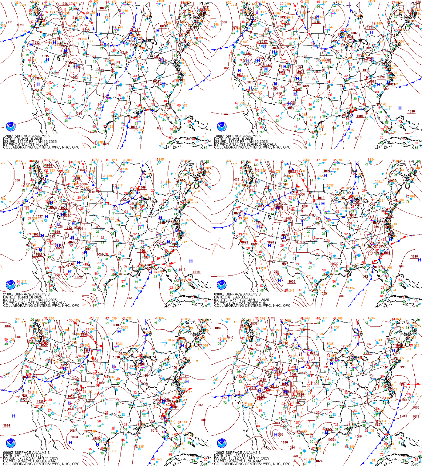
Synoptic summary.
 |
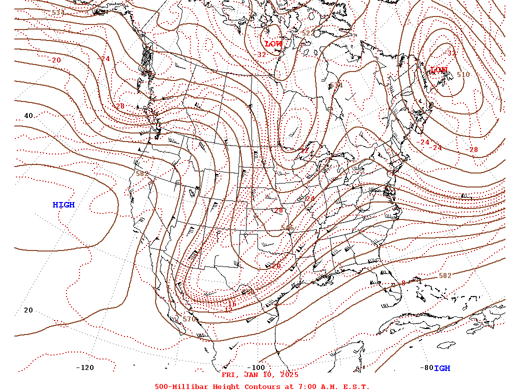 |
| Loop of WPC Surface Analysis from 12z/7 AM on 1-10 to 12z/7 AM on 1-11 in 3 hour increments | 1-10 12z/7 AM WPC 500mb Analysis |
Near-storm environment summary.
 |
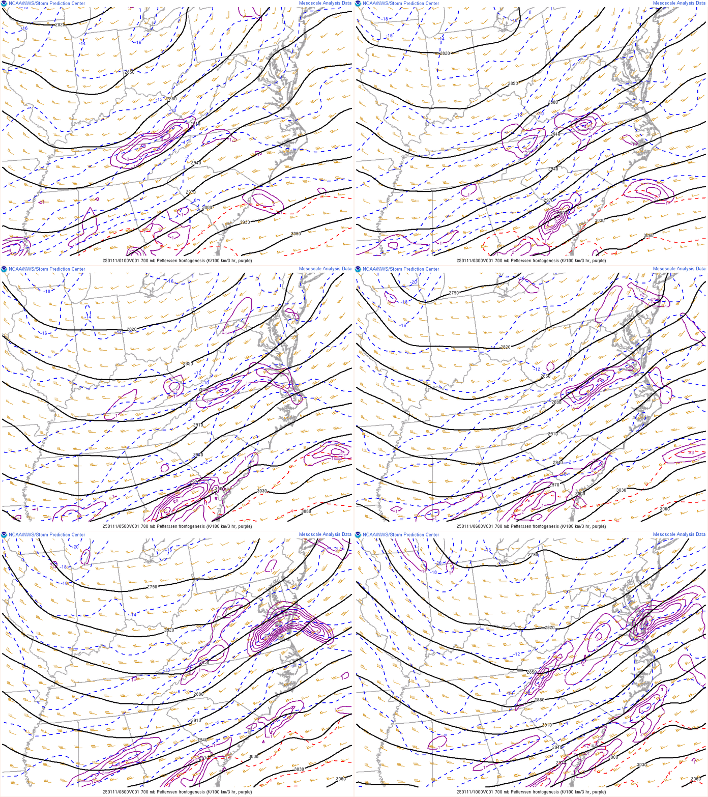 |
| Loop of 850mb Wind/Height/Temperature/Frontogenesis from 01-10z/8 PM to 5 AM during the event | Loop of 700mb Wind/Height/Temperature/Frontogenesis from 01-10z/8 PM to 5 AM during the event |
Near-storm environment summary.
 |
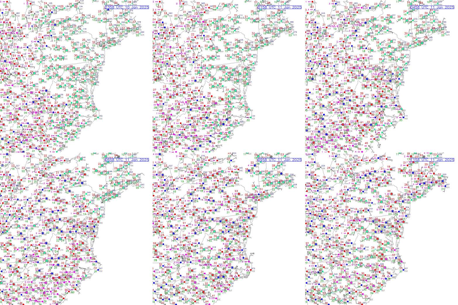 |
| Loop of Max Wet Bulb Temperature Aloft Wind/Height/Temperature/Frontogenesis from 01-10z/8 PM to 5 AM during the event | Loop of Regional Surface Observations from 7 PM to 7 AM in 1 hour increments |
Environmental Sounding Data.
 |
 |
 |
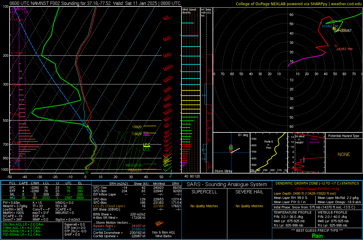 |
| 06z/1 AM NAMNest Analysis Sounding from KAKQ (Wakefield, VA) | 06z/1 AM NAMNest Analysis Sounding from KPTB (Petersburg,VA) | 08z/3 AM 06z NAMNest 2 hour Forecast Sounding from KAKQ (Wakefield, VA) | 08z/3 AM 06z NAMNest 2 hour Forecast Sounding from KPTB (Petersburg,VA) |
 |
Media use of NWS Web News Stories is encouraged! Please acknowledge the NWS as the source of any news information accessed from this site. |
 |