
Thunderstorms, some severe, may produce heavy to excessive rainfall over portions of the Central/Southern Plains, Mississippi Valley and Southeast. Dry and windy conditions will pose an elevated fire weather risk over parts of western Florida. Read More >
Overview
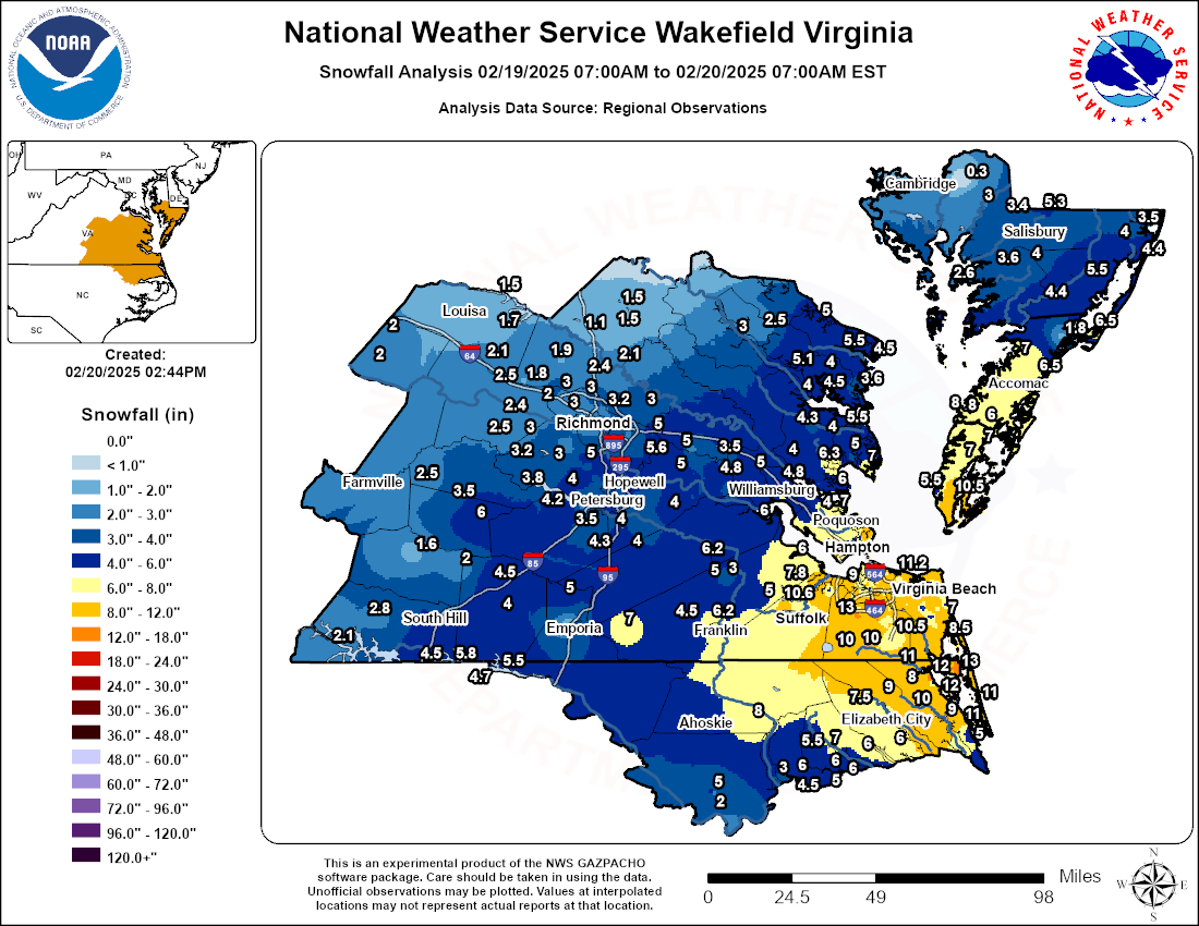
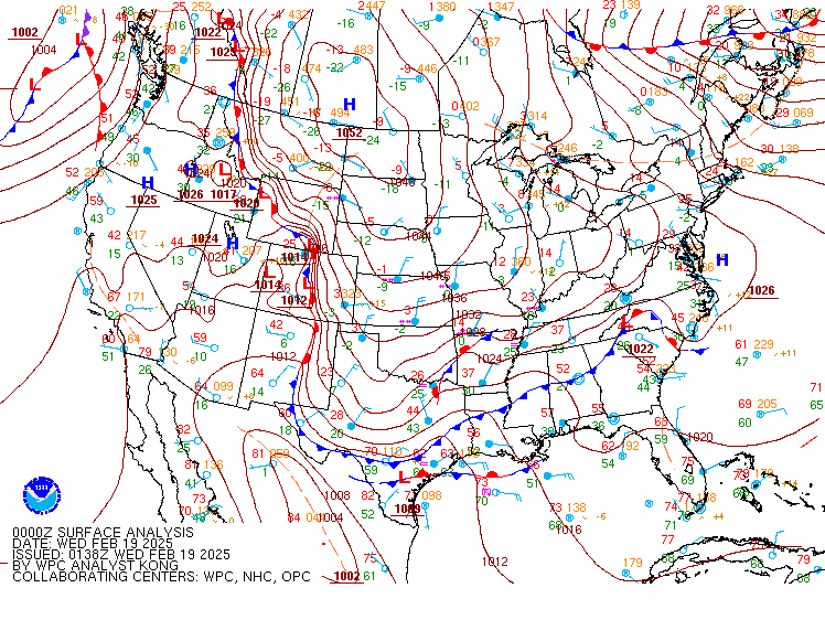
Yet another winter storm impacted the Wakefield CWA…and this one was arguably the most significant of them all in terms of snow totals (although there were very few power outages with this storm). 1050mb+ Arctic high pressure built across the Plains on 2/18, and the expansive Arctic airmass entered the Mid-Atlantic during the early morning hours of 2/19, as temperatures dropped into the upper teens to mid 20s with single digit dew points. Meanwhile, a northern stream shortwave was approaching from the west during the early morning hours of 2/19 while a southern stream shortwave entered the Deep South. These two features would eventually phase later in the day. The phasing of these two shortwaves helped to bring significant snowfall to southern portions of the CWA. But before that, mid-level warm advection/isentropic lift overspread the area during the morning of 2/19, bringing a period of light snow to areas near and north of I-64. While snowfall rates were only 0.1-0.5” per hour, the cold temperatures allowed for snow to quickly accumulate on area roadways. Totals of 1-2” were common by early afternoon across the Richmond Metro.
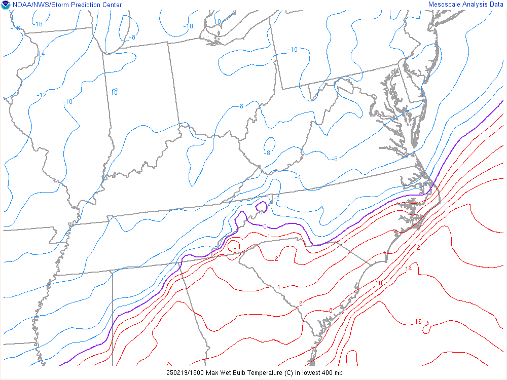
As the two shortwaves began to phase during the afternoon, surface low pressure deepened off the Carolina coast. On the northwest flank of the low (over SE VA and NE NC), an area of 850-700mb frontogenesis began to consolidate. In addition, model cross sections/soundings showed some very weak elevated instability. This allowed for moderate to heavy snow to quickly develop over SE VA and NE NC with rates of 1-2” per hour common. The moderate to heavy snow continued through the evening/early overnight hours as the surface low deepened as it tracked up the coast. In addition, snowfall rates increased from the south-central VA Piedmont to the Richmond Metro during the evening, with rates of 1” per hour observed for a short time. While the pressure gradient on the back side of the low was not strong enough for winds to reach 35 mph (blizzard criteria), gusts to 20-25 mph were observed near the coast with visibilities of ¼ mile in the heavy snow. Fortunately, there were only isolated power outages as the snow was light and fluffy thanks to the Arctic airmass in place. Snow water ratios were close to 15:1 across most of the area, with lower ratios in NE NC. The snow finally ended between 9 PM and 2 AM. Totals were very impressive and ranged from 8-14” in Hampton Roads and NE NC, with 2-7” farther inland. Relatively lower totals (4-8”) were observed right along the Albemarle Sound where sleet mixed in with the snow at times. The 11.0” at ORF surpassed the total from the 1/3/2018 storm, and the 6.2” at the Wakefield NWS office was the highest since 1/3/2018! This will certainly be a storm to remember for those in Hampton Roads.
Snow Map
Radar
Radar Loops
 |
 |
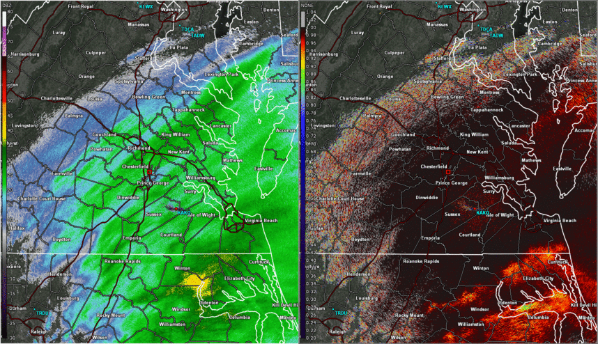 |
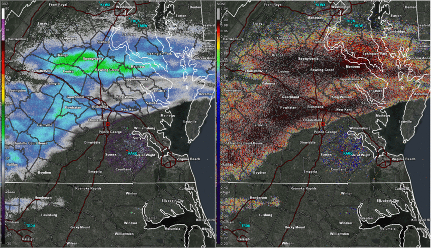
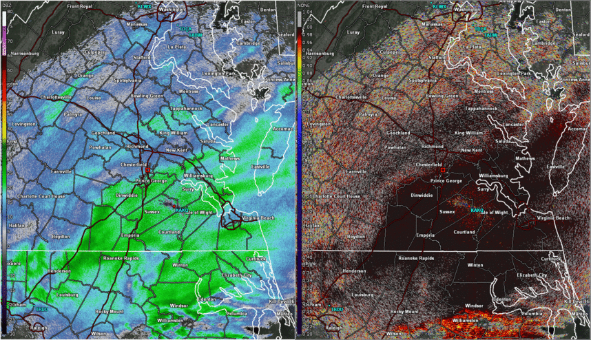
| Loop of Base Reflectivity and Correlation Coefficient from 7am to 1pm on 2/19 in 30 min increments. Precipitation was all in the form of snow during this time. | Loop of Base Reflectivity and Correlation Coefficient from 1pm to 7pm on 2/19 in 30 min increments. The lower CC values over NE NC show sleet mixing in with the snow, which cut down on snow totals. | Loop of Base Reflectivity and Correlation Coefficient from 7pm to 2am on 2/19-20 in 30 min increments. The lower CC values over NE NC show sleet mixing in with the snow, which cut down on snow totals. |
 |
| Loop of Regional Surface Observations from 1 AM on 2-19 to 7 AM 2-20 in 1 hour increments |
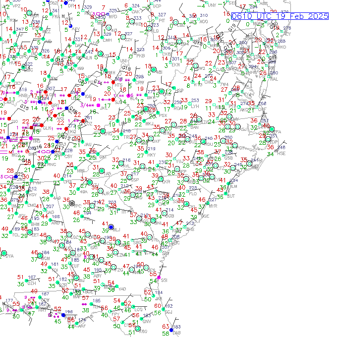
Storm Reports
Public Information Statement National Weather Service Wakefield VA 216 PM EST Thu Feb 20 2025 ...SNOWFALL REPORTS... Location Amount Time/Date Provider ...Maryland... ...Dorchester County... Vienna 3.0 in 0754 PM 02/19 County Official Vienna 3.0 in 0741 PM 02/19 Emergency Mngr East New Market 1.9 SE 0.3 in 0400 AM 02/20 COCORAHS ...Somerset County... 1 NE Princess Anne 3.6 in 0926 PM 02/19 Mesonet Deal Island 0.5 SSW 2.6 in 0700 AM 02/20 COCORAHS 1 NE Princess Anne 2.1 in 0727 PM 02/19 Mesonet ...Wicomico County... Delmar 0.3 ESE 5.3 in 0600 AM 02/20 COCORAHS 1 NNE Salisbury 4.0 in 0424 AM 02/20 Broadcast Media 1 SSE Fruitland 4.0 in 1015 PM 02/19 2 S Delmar 3.6 in 0740 PM 02/19 Public Parsonsburg 1.6 WNW 3.5 in 0700 AM 02/20 COCORAHS 1 NE Hebron 3.4 in 0431 AM 02/20 1 ESE Salisbury 3.0 in 0745 PM 02/19 Broadcast Media 1 ENE Hebron 3.0 in 0700 PM 02/19 Public 1 NE Hebron 2.8 in 0704 PM 02/19 ...Worcester County... Snow Hill 0.4 S 5.5 in 0700 AM 02/20 COCORAHS Pocomoke City 4.4 in 0637 AM 02/20 Broadcast Media Berlin 3.9 SE 4.4 in 0630 AM 02/20 COCORAHS Berlin 4.0 in 0617 AM 02/20 1 W Ocean Pines 3.5 in 0424 AM 02/20 Broadcast Media ...North Carolina... ...Bertie County... 1 WSW Windsor 5.0 in 0900 AM 02/20 Cocorahs 1 SW Windsor 2.0 in 0900 AM 02/20 Law Enforcement ...Camden County... Riddle 11.5 in 0700 AM 02/20 Amateur Radio 1 ENE Burnt Mills 9.0 in 0800 AM 02/20 Broadcast Media ...Chowan County... 1 N Edenton 6.0 in 1150 AM 02/20 Public 1 NNW Edenton 4.5 in 0900 AM 02/20 Cocorahs 3 W Edenton 3.0 in 0604 PM 02/19 Broadcast Media ...Currituck County... 2 NNW Currituck 14.0 in 0120 PM 02/20 Emergency Mngr Knotts Island 13.0 in 0120 PM 02/20 Emergency Mngr Sligo 12.0 in 0120 PM 02/20 Emergency Mngr Maple 12.0 in 0120 PM 02/20 Emergency Mngr 3 NNE Sligo 12.0 in 0120 PM 02/20 Emergency Mngr 2 WNW Moyock 12.0 in 0120 PM 02/20 Emergency Mngr Corolla 11.0 in 0120 PM 02/20 Emergency Mngr Aydlett 11.0 in 0120 PM 02/20 Emergency Mngr 4 NW Moyock 11.0 in 0731 AM 02/20 Public 2 SSW Maple 10.0 in 0120 PM 02/20 Emergency Mngr Waterlily 9.0 in 0629 AM 02/20 Public 1 W Moyock 8.0 in 1100 AM 02/20 Amateur Radio Grandy 0.6 E 5.0 in 0600 AM 02/20 COCORAHS Waterlily 4.5 in 0738 PM 02/19 Broadcast Media 1 NW Currituck 4.0 in 0622 PM 02/19 Amateur Radio ...Hertford County... Harrellsville 8.0 in 0700 AM 02/20 Emergency Mngr Ahoskie 5.5 in 0700 AM 02/20 Emergency Mngr ...Northampton County... 2 SW Henrico 5.5 in 0648 PM 02/19 Amateur Radio 3 WSW Henrico 4.7 in 0630 PM 02/19 ...Pasquotank County... 2 WSW Elizabeth City 8.5 in 0828 AM 02/20 Amateur Radio 3 S Burnt Mills 8.0 in 0948 AM 02/20 Amateur Radio 2 SSW Burnt Mills 7.5 in 0820 AM 02/20 Amateur Radio Elizabeth City 7.7 SSW 6.5 in 0700 AM 02/20 COCORAHS 2 WNW Elizabeth City 6.0 in 1045 AM 02/20 Storm Chaser Nixonton 6.0 in 0926 AM 02/20 Amateur Radio Elizabeth City 5.1 SSE 6.0 in 0700 AM 02/20 COCORAHS ...Perquimans County... 1 NE Hertford 7.0 in 1040 AM 02/20 Newspaper 1 NW Holiday Island 6.0 in 0800 AM 02/20 Amateur Radio 1 NW Holiday Island 6.0 in 0758 AM 02/20 Hertford 5.5 in 1130 PM 02/19 Broadcast Media 1 NW Holiday Island 5.0 in 0800 AM 02/20 Amateur Radio Snug Harbor 5.0 in 0700 AM 02/20 Amateur Radio ...Virginia... ...Accomack County... 5 WSW Pungoteague 8.0 in 0800 AM 02/20 Emergency Mngr 5 WSW Pungoteague 8.0 in 0500 AM 02/20 Emergency Mngr Bloxom 7.0 in 0748 AM 02/20 Trained Spotter Metompkin 0.9 SE 6.5 in 0700 AM 02/20 COCORAHS Chincoteague 6.5 in 0946 PM 02/19 Broadcast Media 2 NNE Exmore 6.0 in 1045 PM 02/19 Public 2 NE Atlantic 1.8 in 0700 PM 02/19 CO-OP Observer ...Amelia County... Jetersville 3.6 W 2.5 in 0700 AM 02/20 COCORAHS ...Brunswick County... 2 NNW Alberta 4.5 in 0933 PM 02/19 Amateur Radio Lawrenceville 4.0 in 0900 AM 02/20 Cocorahs ...Caroline County... Hanover 3.0 N 2.1 in 0700 AM 02/20 COCORAHS Penola 1.5 in 0735 PM 02/19 Public Bowling Green 1.5 in 0706 PM 02/19 Public Ruther Glen 1.7 ENE 1.1 in 0700 AM 02/20 COCORAHS ...Charles City County... 1 SE Roxbury 5.6 in 0957 PM 02/19 Public 2 NW Adkins Store 5.0 in 1120 AM 02/20 Public 1 SE Roxbury 3.5 in 0650 PM 02/19 Public ...Chesterfield County... 2 WSW Meadowville 5.8 in 1155 PM 02/19 NWS Employee 1 NNE Chesterfield 5.0 in 0953 PM 02/19 Amateur Radio Chester 3.3 WSW 4.8 in 0700 AM 02/20 COCORAHS 1 SE Meadowville 4.7 in 0530 AM 02/20 NWS Employee 2 SSW Chesterfield 4.5 in 0815 PM 02/19 NWS Employee 1 NW Chester 4.3 in 0845 PM 02/19 NWS Employee 5 N Sutherland 4.3 in 0945 PM 02/19 Amateur Radio 2 SSE Chester 4.2 in 0730 AM 02/20 NWS Employee 2 SSE Chester 4.1 in 0856 PM 02/19 NWS Employee 3 SSW Meadowville 4.0 in 1222 AM 02/20 Public 2 SE Pocahontas State Park 4.0 in 1220 AM 02/20 NWS Employee 1 W Centralia 4.0 in 0926 PM 02/19 Public 1 W Bon Air 4.0 in 0836 PM 02/19 Public 3 S Midlothian 3.8 in 0801 AM 02/20 2 SSW Chester 3.8 in 0800 AM 02/20 COCORAHS 3.9 SW Beach 3.8 in 0700 AM 02/20 COOP Chesterfield 8.5 WSW 3.8 in 0700 AM 02/20 COCORAHS 4 NW Beach 3.8 in 1037 PM 02/19 Trained Spotter 3 WSW Richmond 3.8 in 0925 PM 02/19 Amateur Radio 2 SE Pocahontas State Park 3.8 in 0809 PM 02/19 Trained Spotter 5 N Sutherland 3.8 in 0755 PM 02/19 Amateur Radio 3 NW Hopewell 3.5 in 0907 PM 02/19 Amateur Radio 1 NW Chesterfield 3.5 in 0744 PM 02/19 Public 1 ESE Chesterfield 3.3 in 0700 PM 02/19 Moseley 1.7 NNE 3.2 in 0700 AM 02/20 COCORAHS 1 SE Meadowville 3.2 in 0759 PM 02/19 NWS Employee 2 SSE Chester 3.2 in 0735 PM 02/19 NWS Employee 3 SSE Midlothian 3.0 in 0912 PM 02/19 Public 3 WSW Richmond 3.0 in 0736 PM 02/19 Amateur Radio 1 ESE Chesterfield 2.8 in 0600 PM 02/19 Public 4 S Bon Air 2.5 in 0612 PM 02/19 NWS Employee 5 N Pocahontas State Park 2.2 in 0725 PM 02/19 Amateur Radio ...City of Chesapeake County... Deep Creek 13.0 in 1155 AM 02/20 Public 1 WNW Great Bridge 12.8 in 0535 AM 02/20 2 SW Greenbrier 12.5 in 1222 AM 02/20 Public 1 WNW Great Bridge 12.0 in 1239 AM 02/20 Greenbrier 11.5 in 1040 AM 02/20 Emergency Mngr 1 WSW Herberts Corner 11.2 in 0730 AM 02/20 Public 2 WSW Great Bridge 10.8 in 1200 AM 02/20 Public 1 SSE Cradock 10.8 in 1159 PM 02/19 Public 1 NNE South Norfolk 10.8 in 1130 PM 02/19 Public Chesapeake 1.8 NE 10.5 in 0700 AM 02/20 COCORAHS 1 W Greenbrier 10.5 in 1140 PM 02/19 Public 1 WNW Fentress 10.5 in 1030 PM 02/19 Trained Spotter 8 SW Chesapeake Airport 10.0 in 1200 PM 02/20 CO-OP Observer 1 NNW Hickory 10.0 in 0745 AM 02/20 COCORAHS 1 WNW Great Bridge 10.0 in 0954 PM 02/19 Great Bridge 9.5 in 1024 PM 02/19 Public 1 N Western Branch 9.5 in 0950 PM 02/19 Amateur Radio Great Bridge 8.5 in 0853 PM 02/19 Trained Spotter Great Bridge 7.5 in 0837 PM 02/19 Public 2 N Deep Creek 7.0 in 0800 AM 02/20 Public 1 S Greenbrier 7.0 in 0800 PM 02/19 Trained Spotter Great Bridge 6.3 in 0737 PM 02/19 Trained Spotter Great Bridge 6.2 in 0739 PM 02/19 Public 2 SSE Hickory 6.1 in 0756 PM 02/19 Public Great Bridge 6.0 in 0738 PM 02/19 Public Great Bridge 5.0 in 0704 PM 02/19 Public 1 WNW Fentress 4.3 in 0721 PM 02/19 Public ...City of Colonial Heights County... 1 E Ettrick 4.0 in 0904 PM 02/19 Public 1 NE Colonial Heights 2.8 in 0610 PM 02/19 NWS Employee ...City of Emporia County... 1 SSW Emporia 5.3 in 0916 PM 02/19 Public Emporia Reservoir T in 0700 AM 02/20 COOP ...City of Franklin County... Hunterdale 6.2 in 1036 PM 02/19 Trained Spotter Hunterdale 6.0 in 0600 AM 02/20 COCORAHS ...City of Hampton County... 1 WNW Hallwood 11.0 in 0915 AM 02/20 Public 1 WNW Hallwood 10.0 in 0709 AM 02/20 Hampton 1.9 NW 10.0 in 0700 AM 02/20 COCORAHS 2 WNW Phoebus 10.0 in 1100 PM 02/19 Public Buckroe Beach 9.5 in 0426 AM 02/20 Public 1 WNW Hallwood 9.5 in 1201 AM 02/20 1 NNE Northampton 9.4 in 1157 PM 02/19 1 WNW Hallwood 8.2 in 0958 PM 02/19 3 W Langley Afb 8.0 in 0200 AM 02/20 Public 1 N Phoebus 8.0 in 0856 PM 02/19 Public Buckroe Beach 7.5 in 0103 PM 02/20 Amateur Radio 1 WSW Raleigh Terrace 7.3 in 0700 AM 02/20 COCORAHS Langley Afb 7.0 in 0100 PM 02/20 Amateur Radio 2 ENE Northampton 7.0 in 0850 PM 02/19 Public 1 WNW Hallwood 7.0 in 0832 PM 02/19 Public 2 WNW Phoebus 6.3 in 0807 PM 02/19 Public Phoebus 6.0 in 0100 PM 02/20 Amateur Radio Buckroe Beach 6.0 in 0744 PM 02/19 Public 2 WNW Phoebus 6.0 in 0724 PM 02/19 Public 1 WNW Hallwood 6.0 in 0724 PM 02/19 Public 1 SE Langley View 6.0 in 0656 PM 02/19 Emergency Mngr 1 NNE Northampton 5.6 in 0812 PM 02/19 1 NE Northampton 5.5 in 0812 PM 02/19 Public 1 NE Northampton 5.5 in 0800 PM 02/19 Public 2 SW Langley View 5.5 in 0709 PM 02/19 Amateur Radio Hampton 3.4 W 5.2 in 0640 AM 02/20 COCORAHS 2 ESE Langley View 5.0 in 0640 PM 02/19 Amateur Radio 2 ENE Northampton 4.0 in 0600 PM 02/19 Public ...City of Hopewell County... 1 NE Hopewell 4.5 in 0915 PM 02/19 Public ...City of Newport News County... 3 SSE Hilton Village 8.5 in 0100 PM 02/20 Amateur Radio 1 WNW Beaconsdale 7.5 in 0858 PM 02/19 Public Newport News 2.5 ESE 7.4 in 0700 AM 02/20 COCORAHS 1 ESE Newport News Golf 6.5 in 0800 AM 02/20 Newport News 2.7 ESE 6.5 in 0600 AM 02/20 COCORAHS 1 SE Patrick Henry Fiel 6.5 in 1037 PM 02/19 Public Newport News 5.8 N 6.2 in 0700 AM 02/20 COCORAHS Beaconsdale 5.0 in 0834 PM 02/19 Public 1 ESE Newport News Golf 4.5 in 0804 PM 02/19 Amateur Radio ...City of Norfolk County... 1 SSW Norfolk International 11.5 in 0158 AM 02/20 Public 2 NNE Norfolk International 11.3 in 0224 AM 02/20 Broadcast Media 1 SE Norview 11.0 in 0700 AM 02/20 CO-OP Observer 1 NNW Ghent 11.0 in 1233 AM 02/20 Public 2 SE Norview 10.6 in 0100 AM 02/20 CO-OP Observer 1 N Norfolk International Ar 10.3 in 0955 PM 02/19 Broadcast Media 2 SE Norview 10.2 in 1200 AM 02/20 CO-OP Observer 1.6 SE Norview 10.2 in 1159 PM 02/19 COOP Downtown Norfolk 10.0 in 0137 AM 02/20 Public 2 NNW Ghent 8.5 in 0930 PM 02/19 Public 1 NE Wards Corner 8.0 in 0730 AM 02/20 Public Downtown Norfolk 8.0 in 1025 PM 02/19 Public 1 WNW Norview 8.0 in 0929 PM 02/19 Public 2 SSW Wards Corner 8.0 in 0922 PM 02/19 Public 2 NW Norfolk International A 7.0 in 0919 PM 02/19 Amateur Radio 1 WNW Norview 6.0 in 0735 PM 02/19 Trained Spotter 1 NNW Ghent 6.0 in 0730 PM 02/19 Public 1 W Wards Corner 5.8 in 0713 PM 02/19 Public 3 ESE Downtown Norfolk 5.8 in 0700 PM 02/19 1 NNW Ghent 5.5 in 0634 PM 02/19 Amateur Radio 2 SE Norview 5.2 in 0700 PM 02/19 CO-OP Observer Willoughby Spit 5.0 in 0649 PM 02/19 Public 1 WSW Downtown Norfolk 4.0 in 0655 PM 02/19 Public ...City of Petersburg County... 1 W Petersburg 5.0 in 1100 PM 02/19 Trained Spotter 1 W Petersburg 4.0 in 0712 PM 02/19 Trained Spotter 2 WSW Petersburg 3.5 in 0753 PM 02/19 Amateur Radio ...City of Poquoson County... Poquoson 6.1 WSW 7.9 in 0700 AM 02/20 COCORAHS ...City of Portsmouth County... 1 E Western Branch 12.0 in 0718 AM 02/20 1 E Western Branch 12.0 in 0641 AM 02/20 Portsmouth 4.1 SSE 10.9 in 0700 AM 02/20 COCORAHS Cradock 10.8 in 1159 PM 02/19 3 SE Churchland 10.0 in 0945 PM 02/19 Broadcast Media 1 SSE Downtown Portsmout 9.5 in 0456 AM 02/20 Broadcast Media Cradock 9.4 in 1000 PM 02/19 Cradock 9.4 in 1000 PM 02/19 Trained Spotter 1 NE Churchland 9.0 in 1100 PM 02/19 Public 1 SW Downtown Portsmout 9.0 in 0952 PM 02/19 Public 2 ESE Western Branch 7.1 in 0828 PM 02/19 Public 1 SSE Downtown Portsmout 6.5 in 0903 PM 02/19 Broadcast Media Downtown Portsmout 6.0 in 0807 PM 02/19 Trained Spotter Cradock 6.0 in 0741 PM 02/19 Public 3 ENE Western Branch 6.0 in 0731 PM 02/19 Public 1 SW Downtown Portsmout 6.0 in 0725 PM 02/19 Trained Spotter 1 WSW Downtown Portsmout 6.0 in 0700 PM 02/19 Public 1 SSE Downtown Portsmout 5.0 in 0743 PM 02/19 Broadcast Media ...City of Richmond County... 2 SSE Lakeside 3.0 in 0645 PM 02/19 Trained Spotter 2 N Downtown Richmond 2.6 in 0659 AM 02/20 Richmond 1.7 N 2.4 in 0700 AM 02/20 COCORAHS 2 SSE Lakeside 2.0 in 0631 PM 02/19 Trained Spotter ...City of Suffolk County... 1 NW Driver 10.6 in 0700 AM 02/20 COCORAHS 2 NNW Kilby 10.0 in 1155 PM 02/19 1 ENE Huntersville 9.8 in 1116 PM 02/19 Trained Spotter 1 NE Huntersville 9.5 in 1055 AM 02/20 NWS Employee Portsmouth 5.1 WNW 9.5 in 0700 AM 02/20 COCORAHS Downtown Suffolk 7.8 in 1000 PM 02/19 Public 1 ENE Downtown Suffolk 7.5 in 1138 PM 02/19 Public 1 ENE Downtown Suffolk 7.1 in 0824 PM 02/19 Public Suffolk 1.4 NNW 7.0 in 0736 AM 02/20 COCORAHS Downtown Suffolk 6.0 in 0811 PM 02/19 Public 1 ENE Huntersville 6.0 in 0727 PM 02/19 Trained Spotter 1 N Deanes 5.5 in 0710 PM 02/19 Amateur Radio ...City of Virginia Beach County... 1 SSE Macons Corner 13.0 in 0700 AM 02/20 2 SSW Gallups Corner 12.6 in 1054 AM 02/20 2 NNW Sigma 12.4 in 0245 AM 02/20 Virginia Beach 3.2 E 12.3 in 0700 AM 02/20 COCORAHS 3 SSW Gallups Corner 12.0 in 0724 AM 02/20 2 E Greenbrier 12.0 in 0640 AM 02/20 2 SSE Gallups Corner 12.0 in 1236 AM 02/20 Public 3 SW Cape Henry 11.5 in 1116 PM 02/19 Public Virginia Beach 2.4 N 11.0 in 0700 AM 02/20 COCORAHS 2 N Munden 11.0 in 1151 PM 02/19 Public 2 SE Norfolk International A 11.0 in 1050 PM 02/19 Public 2 SSW Macons Corner 10.8 in 1100 PM 02/19 Trained Spotter 1 NW Bayside 10.8 in 1056 PM 02/19 Public 2 ENE Gallups Corner 10.8 in 1039 PM 02/19 Public 2 SW Princess Anne 10.8 in 1052 PM 02/19 Public 1 NNW Oceana 10.1 in 1131 PM 02/19 Broadcast Media 3 N London Bridge 10.0 in 1053 PM 02/19 Public Virginia Beach 8.2 NNW 9.5 in 0700 AM 02/20 COCORAHS Virginia Beach 9.4 in 1145 PM 02/19 Public Virginia Beach 9.1 NNW 9.0 in 0700 AM 02/20 COCORAHS 2 SW Gallups Corner 9.0 in 0931 PM 02/19 Amateur Radio 2 S Macons Corner 9.0 in 0852 PM 02/19 Trained Spotter 1 ESE Sigma 8.5 in 1000 AM 02/20 CO-OP Observer 2 N Sigma 8.5 in 0700 AM 02/20 Virginia Beach 3.1 ENE 8.5 in 0700 AM 02/20 COCORAHS 1 NNE Sigma 8.0 in 0915 PM 02/19 Public 3 SSW Gallups Corner 8.0 in 0904 PM 02/19 Public Bayside 8.0 in 0822 PM 02/19 Public 2 NNW Sigma 7.6 in 0800 PM 02/19 Public 2 E Greenbrier 7.3 in 0801 PM 02/19 Public 2 SSE Bayside 7.0 in 0859 PM 02/19 Public 1 W Dam Neck 7.0 in 0823 PM 02/19 Public 1 SSE Macons Corner 7.0 in 0822 PM 02/19 Public 1 SSW Gallups Corner 7.0 in 0821 PM 02/19 Public Princess Anne 7.0 in 0815 PM 02/19 Public Virginia Beach 7.0 in 0814 PM 02/19 Public 2 WNW Kempsville 6.0 in 0757 PM 02/19 Public Kempsville 6.0 in 0743 PM 02/19 Public 2 ESE Norfolk International 5.5 in 0800 PM 02/19 Public 1 W Dam Neck 5.3 in 0723 PM 02/19 Public 2 S Macons Corner 5.0 in 0733 PM 02/19 Trained Spotter 3 NNE London Bridge 4.5 in 0713 PM 02/19 Public 1 NW Pungo 4.5 in 0711 PM 02/19 Public 1 SSW Virginia Beach 4.5 in 0624 PM 02/19 Public 2 NNW Sigma 4.0 in 0600 PM 02/19 Public 2 NNW Princess Anne 3.5 in 0721 PM 02/19 Amateur Radio ...City of Williamsburg County... Williamsburg 0.3 SSW 5.0 in 0700 AM 02/20 COCORAHS 1 N Williamsburg 5.0 in 0912 PM 02/19 Public Williamsburg 1.3 SSW 4.9 in 0500 AM 02/20 COCORAHS 1 NNW Williamsburg Airport 4.5 in 0836 PM 02/19 Public 1 NW Williamsburg 4.0 in 0700 PM 02/19 Public 1 NW Williamsburg 3.0 in 0700 PM 02/19 Public ...Dinwiddie County... Sutherland 5.0 in 0600 AM 02/20 Public 2 WNW Reams 3.5 in 0738 PM 02/19 Amateur Radio 1 NNW Addison 2.5 in 0709 PM 02/19 NWS Employee ...Essex County... 1 NE Tappahannock 3.0 in 0904 PM 02/19 Public ...Fluvanna County... 3 SE Antioch 2.0 in 0830 AM 02/20 COCORAHS 1 N Lake Monticello 2.0 in 0748 PM 02/19 Public ...Gloucester County... Gloucester 3.9 ESE 6.8 in 0700 AM 02/20 COCORAHS 1 S Ware Neck 6.8 in 1126 PM 02/19 1 S Ware Neck 6.8 in 1120 PM 02/19 NWS Employee Gloucester Point 2.4 E 6.4 in 0800 AM 02/20 COCORAHS Gloucester Point 0.6 S 6.3 in 0700 AM 02/20 COCORAHS 1 S Ware Neck 6.3 in 0924 PM 02/19 Public 1 S Ware Neck 6.3 in 0915 PM 02/19 Trained Spotter 1 SE Wicomico 6.0 in 0833 AM 02/20 Achilles 6.0 in 1000 PM 02/19 Public 1 WSW White Marsh 5.4 in 0845 AM 02/20 James Store 1.5 WNW 5.0 in 0700 AM 02/20 COCORAHS 1 SW Achilles 5.0 in 0850 PM 02/19 NWS Employee 1 NW Gloucester Point 5.0 in 0832 PM 02/19 Public Gloucester Courthouse 3.3 SS 4.8 in 0800 AM 02/20 COCORAHS 1 NNE Gloucester Courthouse 4.0 in 0834 AM 02/20 Public Gloucester Courthouse 6.6 W 4.0 in 0700 AM 02/20 COCORAHS 1 WNW Soles 4.0 in 0700 PM 02/19 Public 1 ESE Cash 3.5 in 1115 PM 02/19 Trained Spotter 1 SE Wicomico 3.5 in 0722 PM 02/19 1 S Ware Neck 3.5 in 0617 PM 02/19 Trained Spotter 1 S Ware Neck 3.5 in 0612 PM 02/19 Public Wicomico 3.5 in 0818 PM 02/19 Amateur Radio ...Greensville County... Purdy 5.0 in 0935 PM 02/19 Trained Spotter ...Hanover County... Mechanicsville 1.0 SSE 3.2 in 0700 AM 02/20 COCORAHS 4 WNW Westwood 3.0 in 0725 PM 02/19 Amateur Radio Rockville 5.1 W 2.5 in 0700 AM 02/20 COCORAHS 1 SW Ashland 2.4 in 0630 PM 02/19 CO-OP Observer Montpelier 4.8 E 1.9 in 0703 AM 02/20 COCORAHS 2 S Vontay 1.8 in 0624 PM 02/19 Public ...Henrico County... 1 W Bottoms Bridge 5.0 in 1046 PM 02/19 Trained Spotter 1 WNW Richmond International 4.0 in 0700 AM 02/20 Official NWS Obs Sandston 5.9 ESE 3.5 in 0741 AM 02/20 COCORAHS Montrose 4.7 SSE 3.5 in 0700 AM 02/20 COCORAHS 3 N Short Pump 3.5 in 0939 PM 02/19 3 N Short Pump 3.5 in 0807 PM 02/19 Trained Spotter 1 ENE Longdale 3.5 in 0806 PM 02/19 Trained Spotter 3 N Short Pump 3.2 in 1000 PM 02/19 Public 1 WNW Glen Allen 3.0 in 0921 PM 02/19 Amateur Radio 2 WSW Dumbarton 3.0 in 0807 PM 02/19 Public 3 N Short Pump 3.0 in 0740 PM 02/19 Trained Spotter 1 NE Varina 3.0 in 0722 PM 02/19 Trained Spotter Glen Allen 3.0 in 0627 PM 02/19 Trained Spotter 1 E Longdale 3.0 in 0626 PM 02/19 Public 2 NNE Short Pump 2.2 in 0700 AM 02/20 COCORAHS Henrico 5.8 W 2.0 in 0830 AM 02/20 COCORAHS Richmond 5.3 NW 2.0 in 0700 AM 02/20 COCORAHS Richmond International 2.0 in 0700 PM 02/19 Official NWS Obs 1 ENE Tuckahoe 2.0 in 0636 PM 02/19 Broadcast Media ...Isle of Wight County... Carrollton 3.3 SE 8.8 in 0700 AM 02/20 COCORAHS Wills Corner 7.8 in 0915 PM 02/19 Public 2 NNW Benns Church 6.5 in 0135 AM 02/20 NWS Employee 2 ESE Carrollton 6.5 in 1147 PM 02/19 Public Smithfield 0.7 NE 6.0 in 0700 AM 02/20 COCORAHS 2 NNW Benns Church 6.0 in 0853 PM 02/19 NWS Employee 1 WNW Windsor 5.0 in 0742 PM 02/19 Public ...James City County... 1 WNW Jamestown 6.0 in 0813 PM 02/19 Amateur Radio Williamsburg 6.5 NW 5.5 in 0700 AM 02/20 COCORAHS 1 SSE Ewell 5.0 in 0758 AM 02/20 1 SSW Norge 5.0 in 0713 AM 02/20 Williamsburg 3.4 SW 5.0 in 0700 AM 02/20 COCORAHS Williamsburg 3.2 WNW 5.0 in 0700 AM 02/20 COCORAHS Williamsburg 9.1 NNW 5.0 in 0700 AM 02/20 COCORAHS Toano 1.1 SSW 4.8 in 0700 AM 02/20 COCORAHS Williamsburg 3.2 NW 4.5 in 0800 AM 02/20 COCORAHS Williamsburg 3.4 W 4.2 in 0700 AM 02/20 COCORAHS Lightfoot 4.0 in 0722 PM 02/19 Amateur Radio 1 NNW Kings Corner 3.5 in 0700 PM 02/19 Amateur Radio 3 WNW Governors Land 3.3 in 0715 PM 02/19 Amateur Radio ...Lancaster County... Lancaster 9.0 W 5.1 in 0715 AM 02/20 COCORAHS Lancaster 4.5 in 1237 AM 02/20 Emergency Mngr Urbanna 6.2 NNE 4.0 in 0700 AM 02/20 COCORAHS 1 E Lancaster 4.0 in 0914 PM 02/19 Public ...Louisa County... Gum Spring 3.5 NNW 2.1 in 0646 AM 02/20 COCORAHS 1 E Cuckoo 1.7 in 0817 PM 02/19 Public Mineral 6.9 NNE 1.5 in 0700 AM 02/20 COCORAHS ...Lunenburg County... 2 N Dundas 2.0 in 0618 PM 02/19 Trained Spotter Victoria 0.9 N 1.6 in 0700 AM 02/20 COCORAHS ...Mathews County... Port Haywood 1.0 SE 7.0 in 0700 AM 02/20 COCORAHS Port Haywood 2.1 ESE 6.2 in 0700 AM 02/20 COCORAHS Mathews 5.0 in 0943 PM 02/19 Public 1 SE Cardinal 3.0 in 0609 PM 02/19 Public ...Mecklenburg County... 4 W Ebony 5.8 in 0800 AM 02/20 Cocorahs Bracy 5.0 E 5.8 in 0800 AM 02/20 COCORAHS 1 SE South Hill 5.0 in 0908 PM 02/19 Public Boydton 18.8 ESE 4.5 in 0700 AM 02/20 COCORAHS 2 NE South Hill 3.0 in 0609 PM 02/19 NWS Employee 3 ENE Rogers Corner 2.8 in 0625 PM 02/19 Amateur Radio Clarksville 2.1 in 0700 AM 02/20 COOP ...Middlesex County... Wilton 5.5 in 0800 AM 02/20 Public Hartfield 2.9 W 4.3 in 0700 AM 02/20 COCORAHS ...New Kent County... 1 NNW Mountcastle 5.0 in 1048 PM 02/19 Trained Spotter New Kent 5.0 W 4.2 in 0751 AM 02/20 COCORAHS Providence Forge 2.5 in 0625 PM 02/19 Trained Spotter ...Northampton County... 2 SSE Bay View 10.5 in 1215 AM 02/20 Exmore 7.0 in 1020 PM 02/19 Public Machipongo 7.0 in 0940 PM 02/19 Broadcast Media Cape Charles 5.5 in 0820 PM 02/19 Public 2 SSE Bay View 5.0 in 0659 PM 02/19 ...Northumberland County... Heathsville 4.6 SE 5.5 in 0700 AM 02/20 COCORAHS Lottsburg 2.3 NNE 5.0 in 0700 AM 02/20 COCORAHS Fair Port 4.5 in 0945 PM 02/19 Trained Spotter Kilmarnock 2.3 ESE 3.6 in 0800 AM 02/20 COCORAHS ...Nottoway County... Pattersons Store 6.0 in 0934 PM 02/19 Amateur Radio Pattersons Store 5.0 in 0811 PM 02/19 Amateur Radio Pattersons Store 5.0 in 0610 PM 02/19 Trained Spotter Fergusonville 3.5 in 0931 PM 02/19 ...Powhatan County... Holly Hills 3.0 in 0730 PM 02/19 Amateur Radio Holly Hills 2.5 in 1100 PM 02/19 Public 2 ENE Flat Rock 2.5 in 0923 PM 02/19 Amateur Radio Powhatan 7.8 NE 2.4 in 0720 AM 02/20 COCORAHS ...Prince George County... 2 SSE Templeton 4.5 in 1100 AM 02/20 NWS Employee Disputanta 6.3 NE 4.5 in 0700 AM 02/20 COCORAHS South Prince George 6.8 S 4.3 in 0700 AM 02/20 COCORAHS 1 W Templeton 4.3 in 1000 PM 02/19 1 WNW Templeton 4.1 in 0715 PM 02/19 1 WSW Templeton 4.1 in 0700 PM 02/19 2 ENE Reams 4.0 in 1035 PM 02/19 NWS Employee 2 SSE Fort Gregg-Adams 4.0 in 1030 PM 02/19 NWS Employee 2 SSE Jordans Point 4.0 in 0950 PM 02/19 Amateur Radio 2 NE Templeton 4.0 in 0948 PM 02/19 Amateur Radio 1 W Prince George 4.0 in 0923 PM 02/19 NWS Employee 4 NNW Barham 4.0 in 0855 PM 02/19 Trained Spotter 2 NNE Reams 3.8 in 1200 AM 02/20 NWS Employee Prince George 3.2 ENE 3.4 in 0700 AM 02/20 COCORAHS 2 SSE Prince George Golf 3.0 in 0803 PM 02/19 Amateur Radio ...Richmond County... 1 SE Warsaw 2.5 in 0937 PM 02/19 Public ...Southampton County... Drewryville 2.3 SW 7.0 in 0827 AM 02/20 COCORAHS Franklin 2.6 WNW 6.4 in 0757 AM 02/20 COCORAHS 2 NNW Hunterdale 6.2 in 1027 PM 02/19 Courtland 4.5 in 0616 PM 02/19 Public Ivor 3.0 in 0600 PM 02/19 Public ...Sussex County... 1.5 NW Wakefield 6.2 in 1200 AM 02/20 COOP 1 NW Wakefield 6.2 in 1200 AM 02/20 Official NWS Obs 1 ENE Wakefield 5.0 in 0916 PM 02/19 Public 1 NW Wakefield 5.0 in 0808 PM 02/19 Official NWS Obs 1 NW Wakefield 4.0 in 0700 PM 02/19 Official NWS Obs ...York County... Tabb 8.8 in 1234 AM 02/20 Public 2 SE Tabb 8.0 in 1000 AM 02/20 CO-OP Observer 1 S Seaford 7.0 in 1030 PM 02/19 Public Carver Gardens 7.0 in 1020 PM 02/19 Public Yorktown 7.0 in 0917 PM 02/19 Public Tabb 6.8 in 0907 PM 02/19 Public 1 WNW Harris Grove 6.5 in 1130 PM 02/19 Public Grafton 1.3 ENE 6.3 in 0600 AM 02/20 COCORAHS Newport News 5.8 NE 6.2 in 0700 AM 02/20 COCORAHS 2.1 N Williamsburg 4.0 in 1200 AM 02/20 COOP 1 NNE Tabb 4.0 in 0706 PM 02/19 Amateur Radio Yorktown 4.0 in 0649 PM 02/19 Public Oaktree 3.8 in 0803 PM 02/19 Amateur Radio ...Maritime Stations... Smithfield 6.5 in 0924 PM 02/19 Public 1 WNW Fair Port 3.5 in 0800 PM 02/19 Trained Spotter &&
Environment
Synoptic summary.
 |
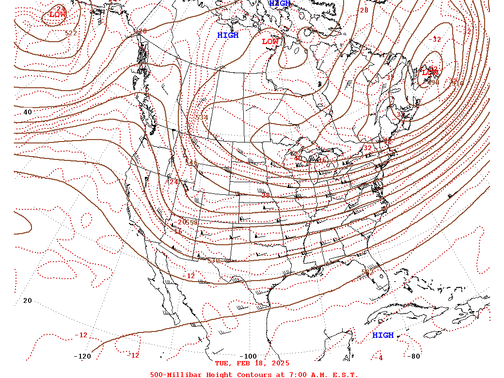 |
| Loop of WPC Surface Analysis from 2-18 at 7 PM to 2-02 at 7 AM in 3 hour increments | Loop of WPC 500mb Analysis from 2-18 to 2-20 (24 hr increments) |
Near-storm environment summary.
 |
 |
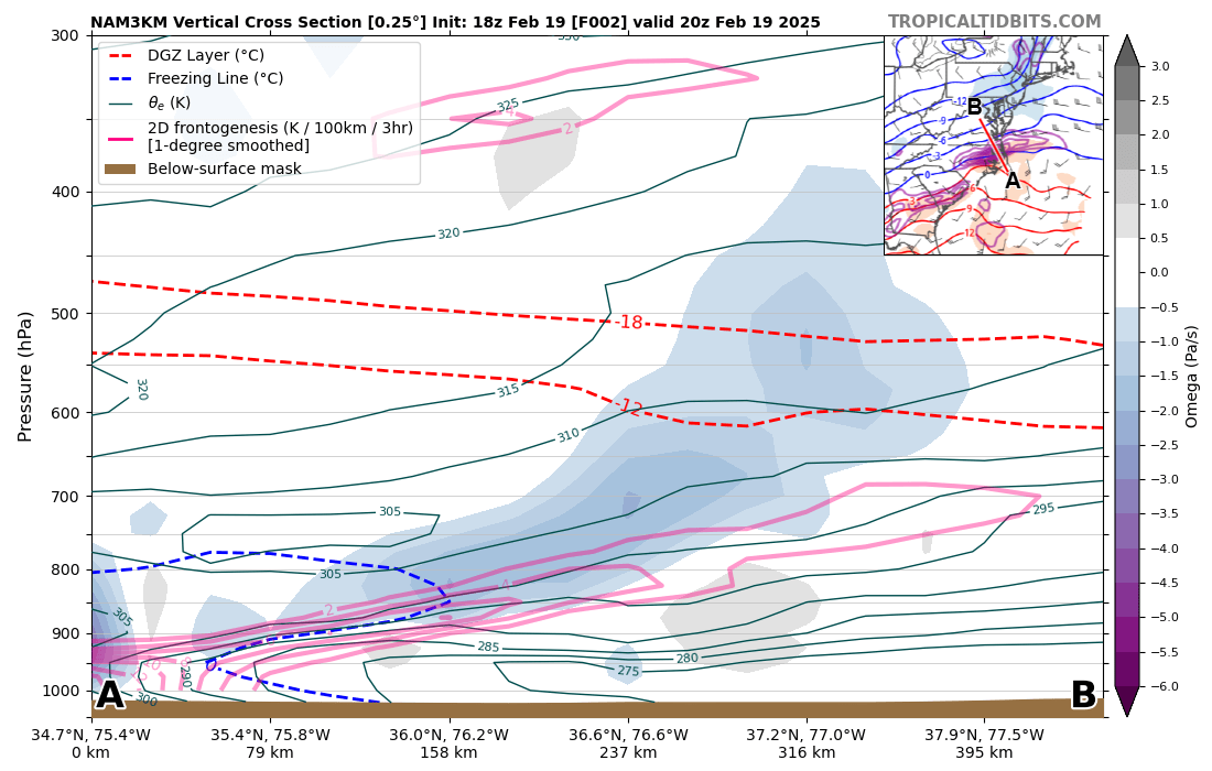 |
| Loop of Max Wet Bulb Temp Aloft from 1 PM to 10 PM | Loop of 700mb Frontogenesis from 1 Pm to 10 PM | 2 hour NAMNest forecast omega/temperature/theta-e/FGen cross section valid at 3 PM on 2/19. Note the well-defined sloping FGen zone in addition to some areas of very weak elevated instability over SE VA/NE NC (can be seen when theta-e is decreasing with height). |
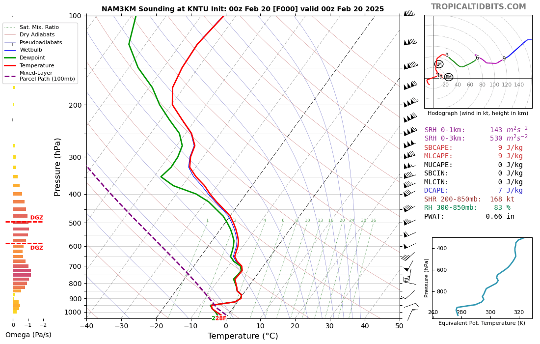
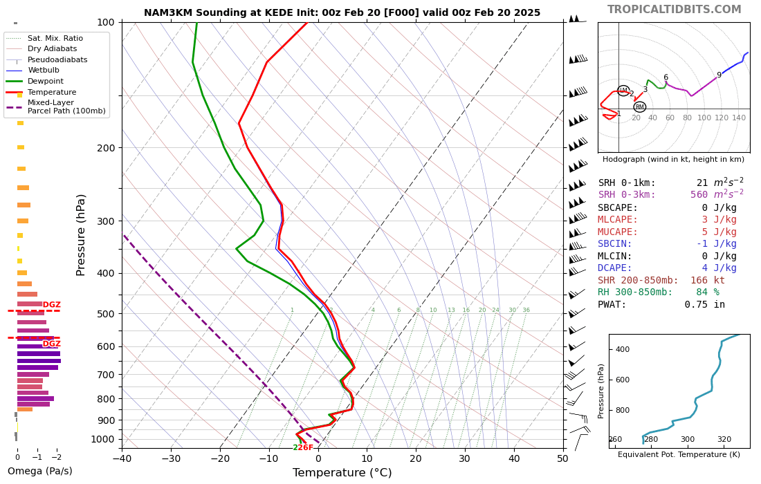
Environmental Sounding Data from 00z/7 PM on 2/19.
 |
 |
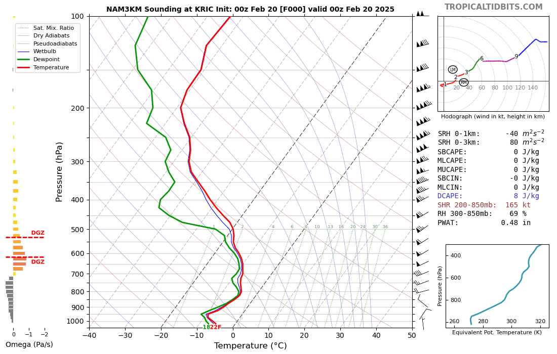 |
| NAMNest Analysis Sounding from KNTU (VA Beach) | NAMNest Analysis Sounding from KEDE (Edenton, NC) | NAMNest Analysis Sounding from KRIC (Richmond, VA) |
 |
Media use of NWS Web News Stories is encouraged! Please acknowledge the NWS as the source of any news information accessed from this site. |
|


 Coastal Flood
 Heat
Heat